Severe Weather Outbreak Monday

U.S. & Caribbean Weather Discussions and Severe Weather Events

Moderator: S2k Moderators

Forum rules

The posts in this forum are NOT official forecast and should not be used as such. They are just the opinion of the poster and may or may not be backed by sound meteorological data. They are NOT endorsed by any professional institution or STORM2K.

Help Support Storm2K
Message
Author
SamSagnella
Category 2
Category 2
Posts: 630
Age: 38
Joined: Fri Aug 26, 2005 12:02 pm
Location: Westport, CT
Contact:

#21 Postby SamSagnella » Mon Mar 13, 2006 3:48 pm

Tornado warning issued for parts of NErn MS -- apparently "A TORNADO WAS REPORTED WITH THIS STORM BETWEEN WALTHALL AND BELLEFONTAINE IN WEBSTER COUNTY AT 218 PM." This storm has has been tornado-warned for a little over an hour now, although the velocity couplet is less-defined now than it has been.

Code: Select all

..TIME...   ...EVENT...      ...CITY LOCATION...     ...LAT.LON...
..DATE...   ....MAG....      ..COUNTY LOCATION..ST.. ...SOURCE....
            ..REMARKS..

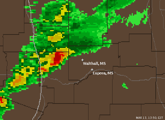
0218 PM     TORNADO          2 NW WALTHALL           33.63N 89.30W
03/13/2006                   WEBSTER            MS   BROADCAST MEDIA

            WTOK TV REPORTS THAT THE PUBLIC REPORTED A TORNADO ON THE
            GROUND NEAR LEGION LAKE.

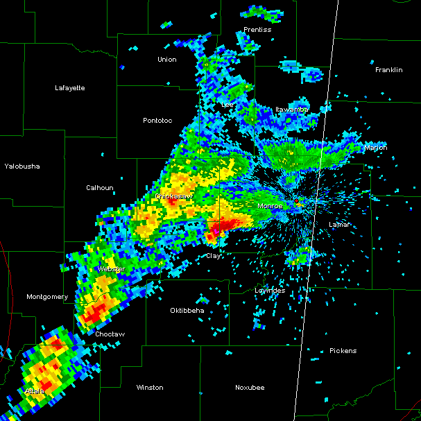
0237 PM     TORNADO          13 NE EUPORA            33.68N 89.12W
03/13/2006                   WEBSTER            MS   LAW ENFORCEMENT

            SHERIFFS SPOTTED ANOTHER TOUCHDOWN JUST NORTH OF THE TOWN
            OF CLARKSTON.

Image
0 likes   

SamSagnella
Category 2
Category 2
Posts: 630
Age: 38
Joined: Fri Aug 26, 2005 12:02 pm
Location: Westport, CT
Contact:

#22 Postby SamSagnella » Mon Mar 13, 2006 4:30 pm

Storm in NErn Mississippi appears to be increasing in intensity as of ~420EST as it enters Monroe County.
Image
0 likes   

User avatar
therock1811
Category 5
Category 5
Posts: 5163
Age: 39
Joined: Thu May 15, 2003 2:15 pm
Location: Kentucky
Contact:

#23 Postby therock1811 » Mon Mar 13, 2006 5:07 pm

I'm tracking storms south of Louisville, KY that have had hail and wind. Also storms developing near Cincinnati, OH. Watching it carefully for possible severe wind and hail.
0 likes   

conestogo_flood
Category 5
Category 5
Posts: 1268
Joined: Wed Sep 28, 2005 5:49 pm

#24 Postby conestogo_flood » Mon Mar 13, 2006 5:36 pm

Of course is all misses me. What a bust!
0 likes   

CrazyC83
Professional-Met
Professional-Met
Posts: 34002
Joined: Tue Mar 07, 2006 11:57 pm
Location: Deep South, for the first time!

#25 Postby CrazyC83 » Mon Mar 13, 2006 5:40 pm

Cold front hasn't hit you yet...
0 likes   

User avatar
therock1811
Category 5
Category 5
Posts: 5163
Age: 39
Joined: Thu May 15, 2003 2:15 pm
Location: Kentucky
Contact:

#26 Postby therock1811 » Mon Mar 13, 2006 5:42 pm

Nope, and I haven't got anything yet either. Within the hour it's gonna go big time I think for central and eastern KY as well as most of OH. Now a Severe T-Storm WARNING for Erie County, OH until 6:15pm ET.
0 likes   

CrazyC83
Professional-Met
Professional-Met
Posts: 34002
Joined: Tue Mar 07, 2006 11:57 pm
Location: Deep South, for the first time!

#27 Postby CrazyC83 » Mon Mar 13, 2006 5:45 pm

Pretty strong cells over Lake Erie that has to be the warning - also good cells forming near Goderich and along the Bruce Peninsula...
0 likes   

CrazyC83
Professional-Met
Professional-Met
Posts: 34002
Joined: Tue Mar 07, 2006 11:57 pm
Location: Deep South, for the first time!

#28 Postby CrazyC83 » Mon Mar 13, 2006 5:46 pm

0 likes   

Brent
S2K Supporter
S2K Supporter
Posts: 38091
Age: 36
Joined: Sun May 16, 2004 10:30 pm
Location: Tulsa Oklahoma
Contact:

#29 Postby Brent » Mon Mar 13, 2006 6:09 pm

Damage reported in Fayette County, AL with the supercell now in Walker County. Also numerous reports of funnel clouds/rotating wall clouds and tornadoes with it.
0 likes   
#neversummer

Brent
S2K Supporter
S2K Supporter
Posts: 38091
Age: 36
Joined: Sun May 16, 2004 10:30 pm
Location: Tulsa Oklahoma
Contact:

#30 Postby Brent » Mon Mar 13, 2006 6:31 pm

PRELIMINARY LOCAL STORM REPORT
NATIONAL WEATHER SERVICE BIRMINGHAM AL
524 PM CST MON MAR 13 2006

..TIME... ...EVENT... ...CITY LOCATION... ...LAT.LON...
..DATE... ....MAG.... ..COUNTY LOCATION..ST.. ...SOURCE....
..REMARKS..

0502 PM TSTM WND DMG 6 SW MILLPORT 33.50N 88.15W
03/13/2006 PICKENS AL LAW ENFORCEMENT

POSSIBLE TORNADO SOUTHWEST OF MILLPORT. DEBRIS VISIBLE
AND A FEW TREES BLOWN DOWN JUST SOUTH OF SR 96 AND FIELDS
ROAD.

PRELIMINARY LOCAL STORM REPORT
NATIONAL WEATHER SERVICE BIRMINGHAM AL
519 PM CST MON MAR 13 2006

..TIME... ...EVENT... ...CITY LOCATION... ...LAT.LON...
..DATE... ....MAG.... ..COUNTY LOCATION..ST.. ...SOURCE....
..REMARKS..

0516 PM TSTM WND DMG KENNEDY 33.58N 87.99W
03/13/2006 LAMAR AL EMERGENCY MNGR

POSSIBLE TORNADO NEAR KENNEDY. A FEW STRUCTURES HAVE BEEN
DAMAGED ALONG HIGHWAY 17.

PRELIMINARY LOCAL STORM REPORT
NATIONAL WEATHER SERVICE BIRMINGHAM AL
514 PM CST MON MAR 13 2006

..TIME... ...EVENT... ...CITY LOCATION... ...LAT.LON...
..DATE... ....MAG.... ..COUNTY LOCATION..ST.. ...SOURCE....
..REMARKS..

0448 PM TSTM WND DMG WINFIELD 33.93N 87.80W
03/13/2006 MARION AL EMERGENCY MNGR

POSSIBLE TORNADO NEAR WINFIELD. TREES AND POWER LINES
WERE BLOWN DOWN ALONG US 43 IN WINFIELD.


PRELIMINARY LOCAL STORM REPORT...CORRECTED
NATIONAL WEATHER SERVICE BIRMINGHAM AL
512 PM CST MON MAR 13 2006

..TIME... ...EVENT... ...CITY LOCATION... ...LAT.LON...
..DATE... ....MAG.... ..COUNTY LOCATION..ST.. ...SOURCE....
..REMARKS..

0450 PM TSTM WND DMG 15 N FAYETTE 33.91N 87.83W
03/13/2006 FAYETTE AL COUNTY OFFICIAL

POSSIBLE TORNADO IN NORTHERN FAYETTE. TREES BLOWN DOWN
ALONG US 43 NEAR WEEKS ROAD.
0 likes   
#neversummer

Brent
S2K Supporter
S2K Supporter
Posts: 38091
Age: 36
Joined: Sun May 16, 2004 10:30 pm
Location: Tulsa Oklahoma
Contact:

#31 Postby Brent » Mon Mar 13, 2006 7:32 pm

Sounds like a large tornado crossed I-65 near the Cullman/Blount County line about 20 minutes ago. Debris reported.

...A TORNADO WARNING REMAINS IN EFFECT UNTIL 645 PM CST FOR CENTRAL
BLOUNT COUNTY...

AT 626 PM CST...NATIONAL WEATHER SERVICE DOPPLER RADAR AND STORM
SPOTTERS WERE TRACKING A DANGEROUS TORNADO. THIS TORNADO WAS
LOCATED NEAR HAYDEN...OR ABOUT 7 MILES NORTHEAST OF RICKWOOD
CAVERNS...MOVING EAST AT 35 MPH.
0 likes   
#neversummer

User avatar
jasons2k
Storm2k Executive
Storm2k Executive
Posts: 8245
Age: 51
Joined: Wed Jul 06, 2005 12:32 pm
Location: The Woodlands, TX

#32 Postby jasons2k » Mon Mar 13, 2006 7:32 pm

Man, lots of warnings for AL. The cell heading towards Jefferson County is heading straight towards my Grandfather's area.
0 likes   

CrazyC83
Professional-Met
Professional-Met
Posts: 34002
Joined: Tue Mar 07, 2006 11:57 pm
Location: Deep South, for the first time!

#33 Postby CrazyC83 » Mon Mar 13, 2006 7:37 pm

Wow, this outbreak just does not want to end!!!
0 likes   

User avatar
jasons2k
Storm2k Executive
Storm2k Executive
Posts: 8245
Age: 51
Joined: Wed Jul 06, 2005 12:32 pm
Location: The Woodlands, TX

#34 Postby jasons2k » Mon Mar 13, 2006 7:44 pm

GrLevel3 just detected a meso with the cell moving into Birmingham. ouch!
0 likes   

CrazyC83
Professional-Met
Professional-Met
Posts: 34002
Joined: Tue Mar 07, 2006 11:57 pm
Location: Deep South, for the first time!

#35 Postby CrazyC83 » Mon Mar 13, 2006 7:49 pm

Ouch! This could be bad!!! I wonder if there is any area coverage available???
0 likes   

User avatar
jasons2k
Storm2k Executive
Storm2k Executive
Posts: 8245
Age: 51
Joined: Wed Jul 06, 2005 12:32 pm
Location: The Woodlands, TX

#36 Postby jasons2k » Mon Mar 13, 2006 7:54 pm

CrazyC83 wrote:Ouch! This could be bad!!! I wonder if there is any area coverage available???


http://www.nbc13.com/videostream/5842366/detail.html
0 likes   

Brent
S2K Supporter
S2K Supporter
Posts: 38091
Age: 36
Joined: Sun May 16, 2004 10:30 pm
Location: Tulsa Oklahoma
Contact:

#37 Postby Brent » Mon Mar 13, 2006 7:57 pm

Best Weather Coverage in Birmingham.

http://www.al.com/abc3340/video/index.ssf

I've been watching on TV ever since this event started about 3 hours ago...
0 likes   
#neversummer

User avatar
WaitingForSiren
Category 1
Category 1
Posts: 383
Joined: Sun Jan 08, 2006 12:58 pm
Location: Minneapolis,Minnesota
Contact:

#38 Postby WaitingForSiren » Mon Mar 13, 2006 8:05 pm

While an isolated tornado or two is likely across northern AL before the night is over, todays event set up wasnt anything special to begin with. Convective debris was all over the place this morning and instability was marginal at best. I am honestly amazed that SPC actually issued that large a Moderate risk earlier, especially with those tornado probabilites. Seemed obvious to me that today would be a non event.
0 likes   

Brent
S2K Supporter
S2K Supporter
Posts: 38091
Age: 36
Joined: Sun May 16, 2004 10:30 pm
Location: Tulsa Oklahoma
Contact:

#39 Postby Brent » Mon Mar 13, 2006 8:07 pm

WaitingForSiren wrote:While an isolated tornado or two is likely across northern AL before the night is over, todays event set up wasnt anything special to begin with. Convective debris was all over the place this morning and instability was marginal at best. I am honestly amazed that SPC actually issued that large a Moderate risk earlier, especially with those tornado probabilites. Seemed obvious to me that today would be a non event.


I thought it would be a non-event down here and I was wrong... :roll:
0 likes   
#neversummer

MiamiensisWx

#40 Postby MiamiensisWx » Mon Mar 13, 2006 8:15 pm

SEVERE WEATHER STATEMENT
NATIONAL WEATHER SERVICE BIRMINGHAM AL
710 PM CST MON MAR 13 2006

ALC125-140130-
/O.CON.KBMX.TO.W.0021.000000T0000Z-060314T0130Z/
TUSCALOOSA AL-
710 PM CST MON MAR 13 2006

...A TORNADO WARNING REMAINS IN EFFECT UNTIL 730 PM CST FOR
TUSCALOOSA COUNTY...

AT 706 PM CST...NATIONAL WEATHER SERVICE DOPPLER RADAR CONTINUED TO
INDICATE A TORNADO. THIS TORNADO WAS LOCATED ACROSS SOUTHWEST
SECTIONS OF THE COUNTY MOVING NORTHWEST AT 25 MPH.

THE TORNADO WILL EFFECT THE CITY OF TUSCALOOSA AND NORTHPORT.

THE SAFEST PLACE TO BE DURING A TORNADO IS IN A BASEMENT. GET UNDER A
WORKBENCH OR OTHER PIECE OF STURDY FURNITURE. IF NO BASEMENT IS
AVAILABLE...SEEK SHELTER ON THE LOWEST FLOOR OF THE BUILDING IN AN
INTERIOR HALLWAY OR ROOM SUCH AS A CLOSET. USE BLANKETS OR PILLOWS TO
COVER YOUR BODY AND ALWAYS STAY AWAY FROM WINDOWS.

IF IN MOBILE HOMES OR VEHICLES...EVACUATE THEM AND GET INSIDE A
SUBSTANTIAL SHELTER. IF NO SHELTER IS AVAILABLE...LIE FLAT IN THE
NEAREST DITCH OR OTHER LOW SPOT AND COVER YOUR HEAD WITH YOUR HANDS.

A TORNADO WATCH REMAINS IN EFFECT UNTIL 1100 PM CST MONDAY EVENING
FOR NORTHEASTERN ALABAMA. A TORNADO WATCH ALSO REMAINS IN EFFECT
UNTIL 800 PM CST MONDAY EVENING FOR NORTHWESTERN ALABAMA.

LAT...LON 3345 8776 3308 8779 3320 8756 3324 8726
3356 8746

$$

KSL
0 likes   


Return to “USA & Caribbean Weather”

Who is online

Users browsing this forum: Pas_Bon and 19 guests