 The posts in this forum are NOT official forecast and should not be used as such. They are just the opinion of the poster and may or may not be backed by sound meteorological data. They are NOT endorsed by any professional institution or

During the next 7-10 days, a NAO-/PNA- setup is likely to predominate. Afterward, until perhaps the closing days of March, a NAO-/PNA+ regime could hold. Overall, the NAO is likely to remain negative for 10 or more days.
Since 1950, there have been 20 years in which the NAO was negative for 10 or more consecutive days in at least the March 16-April 5 timeframe. 15/20 (75%) saw at least one precipitation event that brought 1.00” or more to at least one of the big cities from Washington, DC to Boston. If Richmond is added to the mix, 18/20 (90%) saw such an event. Consequently, historic data with long-duration mid- to late-March blocks suggests a strong likelihood that the March 16-31 period will ultimately see such a storm.
Arguably, the most likely timeframe might be in the March 20-27 period (something others such as John aka Typhoon Tip have noted in their analyses of the evolving pattern).
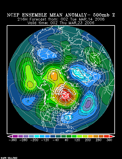
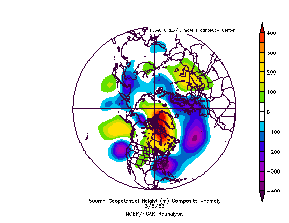
The 3/14 0z NCEP Ensemble Mean 500 mb Height Anomalies forecast for 3/23 0z bear some similarities to the patterns that were in place during or at the end of three prominent storms: March 18-21, 1958, March 5-7, 1962, and March 28-30, 1984.
A closer look is in order:
NCEP Ensemble Mean 500 mb Height Anomalies (3/23 0z):
March 21, 1958:

March 6, 1962:
March 29, 1984:

In 1958 and 1962, the blocks were much stronger than what is currently expected. Also, in 1958, the synoptic pattern most closely resembled the 3/23 0z idea toward the end of the snowstorm. All three events had in common a low that either moved off the Mid-Atlantic coast or hugged the coast. None saw a storm that tracked west of the Appalachians. Hence, at this point, if there is a storm, I believe a track on the coast or offshore is more likely than one to the west of the Appalachians. Interior sections would probably have the greatest risk of seeing meaningful frozen precipitation. But frozen precipitation might be possible even in the big cities, but this is not assured. Scenarios where the coast sees rain change to snow as a system bombs out or snow that changes to rain as milder air takes hold are in the realm of possibility.
Colder weather should follow the storm. With the PNA likely to move positive later in the second half of March, the cold could try to hang on. Nonetheless, the 3/16-21 period is likely to be the coldest timeframe. With no strong indication of a NAO+ PNA- setup, the kind of blowtorch that resulted in the 3/9-14 period is not likely. The idea of generally below normal readings in the Great Lakes region, Mid-Atlantic states, and New England is well-supported on the latest ensemble data.
Summary:
∙ March 16-18: Possible light to moderate snows likely in southeast Michigan (including Detroit) and then the northern Mid-Atlantic to southern New England. Philadelphia and New York City should pick up some accumulations. Some accumulations are also possible in Providence and Boston.
∙ March 16-21: Temperatures should average below to much below normal in Boston, Detroit, New York City, Philadelphia, Providence, Richmond, and Washington, DC. Lowest readings should fall into the 20s on one or more days in all of these cities. A low in the teens is possible on at least one day in Detroit, Boston, and Providence. With the exception of Richmond, each of these cities might see one day with a high temperature no higher than the 30s.
∙ March 20-27: Possible significant coastal storm.
∙ March 23-31: Below normal readings likely in the Great Lakes region and from Richmond to Boston.
NAO/PNA Setups and Mean Temperatures (March 16-31):
NAO: 0 to -2.000/PNA+
Boston: 39.2°
Detroit: 37.2°
New York City: 42.7°
Philadelphia: 43.2°
Washington, DC (DCA): 46.3°
NAO: 0 to -2.000/PNA-
Boston: 40.2°
Detroit: 37.6°
New York City: 43.6°
Philadelphia: 44.4°
Washington, DC (DCA): 48.1°
NAO: 0 to +2.000/PNA+
Boston: 39.4°
Detroit: 37.2°
New York City: 43.5°
Philadelphia: 44.3°
Washington, DC (DCA): 47.6°
NAO: 0 to +2.000/PNA-
Boston: 43.1°
Detroit: 41.8°
New York City: 46.9°
Philadelphia: 47.3°
Washington, DC (DCA): 50.9°
Historical Tidbit: “Equinoctial” Storms:
In the past, it was believed that the sun’s crossing the Equator in the spring and autumn marked particularly stormy periods. This belief was based on the then widely-held premise that the movements of celestial bodies governed phenomena such as weather.
Classical Roman poet Gaius Valerius Catullus once described the arrival of Spring as follows:
Now spring brings back balmy warmth,
now the sweet gales of Zephyr are hushing
the rage of the equinoctal sky.
During the 19th century, separate research endeavors by the British Meteorological Office’s Dr. Robert H. Scott and the U.S. Signal Services’s Professor H. A. Hazen both concluded the Autumnal or Vernal Equinox did not hold any special significance with respect to storminess. In the November 1889 edition of Monthly Weather Review, Hazen wrote of his findings, “The conclusion is inevitable, that the observations do not show a preponderance of storm action during the equinoxes.”


