SEVERE weather for Texas....
Moderator: S2k Moderators
Forum rules

The posts in this forum are NOT official forecast and should not be used as such. They are just the opinion of the poster and may or may not be backed by sound meteorological data. They are NOT endorsed by any professional institution or STORM2K.
-
WaitingForSiren

- Category 1

- Posts: 383
- Joined: Sun Jan 08, 2006 12:58 pm
- Location: Minneapolis,Minnesota
- Contact:
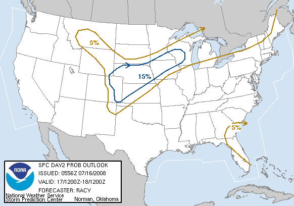
Im confused about todays day 2 severe weather outlook issued by SPC, they outline a 25% probability area yet in their tables it says the only level higher than 15% is 30%. Is this some kind of error on their part, or can they just issue whatever probabilities they feel like, or what? Thanks in advance.
0 likes
-
wxmann_91

- Category 5

- Posts: 8007
- Age: 34
- Joined: Fri Jul 15, 2005 2:49 pm
- Location: Southern California
- Contact:
WaitingForSiren wrote:Im confused about todays day 2 severe weather outlook issued by SPC, they outline a 25% probability area yet in their tables it says the only level higher than 15% is 30%. Is this some kind of error on their part, or can they just issue whatever probabilities they feel like, or what? Thanks in advance.
I didn't notice that before. That's a pretty good question.
0 likes
-
aggiecutter
- Category 5
- Posts: 1755
- Joined: Thu Oct 14, 2004 9:22 pm
- Location: Texarkana
If the forcast is correct, I'll be needing an Arc by the end of the weekend. We still need a lot of rain in the southern plains region to replenish the water supply in the lakes and rivers.
http://www.srh.noaa.gov/ifps/MapClick.p ... 3&map.y=89
http://www.srh.noaa.gov/ifps/MapClick.p ... 3&map.y=89
0 likes
-
wxmann_91
- Category 5
- Posts: 8007
- Age: 34
- Joined: Fri Jul 15, 2005 2:49 pm
- Location: Southern California
- Contact:
Matt-hurricanewatcher wrote:How many tornaodes could there be?
Don't know. Yesterday's runs showed a good low-amplitude slightly negatively-tilted trough, along with a ~990 mb low. Today's 12Z run IMO can be discarded since many times this past winter it is usually around the 72-84 hr that lows dissapear only to reappear stronger. In addition, the NAM has the 500 mb trough over the intermountain west at 84 hr, whereas the GFS over Kansas. So the models don't have a good grasp on this yet. Without a strong Pac Jet and Bermuda High to bring up moisture, and a somewhat weaker/more westerly LLJ, this does not look like a big outbreak. Add to the fact the LLJ will be strongest overnight, it looks very much like there will be junk convection to contend with in the morning, and instability will be a big problem.
0 likes
-
WaitingForSiren
- Category 1
- Posts: 383
- Joined: Sun Jan 08, 2006 12:58 pm
- Location: Minneapolis,Minnesota
- Contact:
I agree I think the biggest severe threat comes Monday when this system moves out. I think that threat area will be centered over eastern LA, AL and MS. I dont think there will be a big tornado outbreak either way or even A tornado outbreak, but I could see several tornadoes over those areas.
0 likes
-
conestogo_flood
- Category 5
- Posts: 1268
- Joined: Wed Sep 28, 2005 5:49 pm
-
TexasStooge

- Category 5
- Posts: 38127
- Joined: Tue Mar 25, 2003 1:22 pm
- Location: Irving (Dallas County), TX
- Contact:
-
cheezyWXguy

- Category 5
- Posts: 6282
- Joined: Mon Feb 13, 2006 12:29 am
- Location: Dallas, TX
-
TexasStooge
- Category 5
- Posts: 38127
- Joined: Tue Mar 25, 2003 1:22 pm
- Location: Irving (Dallas County), TX
- Contact:
-
cheezyWXguy
- Category 5
- Posts: 6282
- Joined: Mon Feb 13, 2006 12:29 am
- Location: Dallas, TX
-
Yankeegirl

- Category 5
- Posts: 3417
- Age: 50
- Joined: Sun May 23, 2004 11:59 pm
- Location: Cy-Fair, Northwest Houston
- Contact:
-
southerngale

- Retired Staff

- Posts: 27418
- Joined: Thu Oct 10, 2002 1:27 am
- Location: Southeast Texas (Beaumont area)
I hope we can get some rain in Southeast Texas. We've had a lot of wildfires in the past several days, and they're getting way too close to my house for comfort. Yesterday a train going by sparked a series of fires near a middle school. Fortunately, they were able to contain those pretty quickly. They were near houses and one of them was approaching flammable railroad timbers, and that would have made things much worse.
Lumberton (a town 5 miles north of Beaumont) has battled 20 fires in the past 3 days. Come on rain!
Lumberton (a town 5 miles north of Beaumont) has battled 20 fires in the past 3 days. Come on rain!
0 likes


-
Portastorm

- Storm2k Moderator

- Posts: 9955
- Age: 63
- Joined: Fri Jul 11, 2003 9:16 am
- Location: Round Rock, TX
- Contact:
jschlitz wrote:I wonder if the NWS in houston is alseep at the wheel tonight. They said they were removing mention of any thunder for tonight in the last AFD. Looks like this shortwave has some punch to it if you ask me though.
I thought the same thing last night about our locals in AUS/SAT, as severe thunderstorms were rumbling across portions of the Hill Country west of us. Turns out, once again, the experts at NWS were right. The "heavy stuff" stayed out west and moved northeast while all we saw overnight were some occasional showers.
Now this morning the action is starting to heat up here in south central Texas. Currently have a nasty cell to our northwest and under a Severe Thunderstorm Watch until 11 a.m.
Not griping though ... the rain for us this weekend has been great with more to come!
0 likes
-
Portastorm
- Storm2k Moderator
- Posts: 9955
- Age: 63
- Joined: Fri Jul 11, 2003 9:16 am
- Location: Round Rock, TX
- Contact:
Portastorm wrote:jschlitz wrote:I wonder if the NWS in houston is alseep at the wheel tonight. They said they were removing mention of any thunder for tonight in the last AFD. Looks like this shortwave has some punch to it if you ask me though.
I thought the same thing last night about our locals in AUS/SAT, as severe thunderstorms were rumbling across portions of the Hill Country west of us. Turns out, once again, the experts at NWS were right. The "heavy stuff" stayed out west and moved northeast while all we saw overnight were some occasional showers.
Now this morning the action is starting to heat up here in south central Texas. Currently have a nasty cell to our northwest and under a Severe Thunderstorm Watch until 11 a.m.
Not griping though ... the rain for us this weekend has been great with more to come!
Looks like a rough night for us ... Tornado Watch just has been issued for the Hill Country and areas west.
0 likes
-
Yankeegirl
- Category 5
- Posts: 3417
- Age: 50
- Joined: Sun May 23, 2004 11:59 pm
- Location: Cy-Fair, Northwest Houston
- Contact:
-
HurricaneHunter914
- Category 5
- Posts: 4439
- Age: 32
- Joined: Fri Mar 10, 2006 7:36 pm
- Location: College Station, TX

-
gboudx

- S2K Supporter

- Posts: 4090
- Joined: Thu Sep 04, 2003 1:39 pm
- Location: Rockwall, Tx but from Harvey, La
Well we got, and are getting, our drought busting rain up here. From Friday to this afternoon, my rain gauge had over 4.5". I dumped it out and checked it about 2 hours ago and it was up over 3.5". And the rain continues to fall.
I ain't complaining; I just hope people are smart about the flash flooding.
I ain't complaining; I just hope people are smart about the flash flooding.
0 likes
Return to “USA & Caribbean Weather”
Who is online
Users browsing this forum: Brent and 84 guests