Major tornado outbreak Sunday...the aftermath..
Moderator: S2k Moderators
Forum rules

The posts in this forum are NOT official forecast and should not be used as such. They are just the opinion of the poster and may or may not be backed by sound meteorological data. They are NOT endorsed by any professional institution or STORM2K.


-
conestogo_flood
- Category 5

- Posts: 1268
- Joined: Wed Sep 28, 2005 5:49 pm
-
conestogo_flood
- Category 5
- Posts: 1268
- Joined: Wed Sep 28, 2005 5:49 pm
-
wxmann_91

- Category 5
- Posts: 8007
- Age: 34
- Joined: Fri Jul 15, 2005 2:49 pm
- Location: Southern California
- Contact:
conestogo_flood wrote:I mean based on todays models, if they were models for tomorrow, what would it be? Slight/Mod/High?
SLGT (Thursday)
Linear forcing along with unidirectional wind profiles and limited instability and moisture screams of a squall line... similar to March 4.
SLGT (Wednesday)
Isolated supercells may develop, but moisture is limited again and capping may be too strong for initiation.
0 likes
-
6SpeedTA95
- Category 5
- Posts: 1206
- Joined: Wed Oct 19, 2005 3:25 pm
- Location: Oklahoma
- Contact:
wxmann_91 wrote:conestogo_flood wrote:I mean based on todays models, if they were models for tomorrow, what would it be? Slight/Mod/High?
SLGT (Thursday)
Linear forcing along with unidirectional wind profiles and limited instability and moisture screams of a squall line... similar to March 4.
SLGT (Wednesday)
Isolated supercells may develop, but moisture is limited again and capping may be too strong for initiation.
I would suspect that we'll have a moderate chance of severe weather from I35 East to the MS river. Where exactly inthere will fall the "moderate" risk I'mnot sure yet, but at this point thats what I'm thinking.
0 likes
-
6SpeedTA95
- Category 5
- Posts: 1206
- Joined: Wed Oct 19, 2005 3:25 pm
- Location: Oklahoma
- Contact:
***NOT AN OFFICIAL FORCAST***
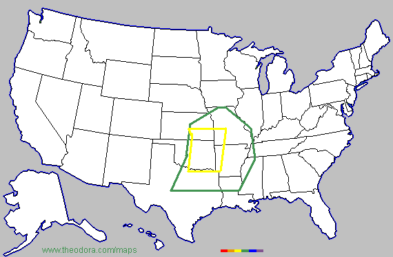
Green represents a slight risk yellow a moderate risk...
the way things are shaping up this could change, and we may have a "high" risk but honestly its way to early to make such a call. At least IMO. The ingredients are there, the thing now is timing. I think the moderate risk of severe weather will be dependant on when/where weather starts developing along with the potential risk for tornadoes.
0 likes
-
wxmann_91
- Category 5
- Posts: 8007
- Age: 34
- Joined: Fri Jul 15, 2005 2:49 pm
- Location: Southern California
- Contact:
After looking at the 0Z GFS, the winds are strong veered and unidirectional across the warm sector. I can almost guarentee any supercell that manages to develop will be at the cold core, this screams of squall line. Tornado outbreak likelihood, if run is taken verbatim, is almost naught excluding possibility of cold core. Isolated tornadoes though are possible invof the cold core upper low and embedded sups in the squall line, but if anything, there is almost NO possibility of a HIGH unless they predict a mammoth derecho or something.
0 likes
-
tornadotony
wxmann_91 wrote:After looking at the 0Z GFS, the winds are strong veered and unidirectional across the warm sector. I can almost guarentee any supercell that manages to develop will be at the cold core, this screams of squall line. Tornado outbreak likelihood, if run is taken verbatim, is almost naught excluding possibility of cold core. Isolated tornadoes though are possible invof the cold core upper low and embedded sups in the squall line, but if anything, there is almost NO possibility of a HIGH unless they predict a mammoth derecho or something.
Yeah, but I'm noticing that the NWS offices are going with the Euro and UKMET, with NWS Tulsa mentioning "ISOLATED, LONG-LIVED SUPERCELLS" along the dryline in their AFD. I think, along with many others on other sites, that this could be a nasty tornado outbreak per 3/12, perhaps on a slightly smaller scale. More tomorrow.
0 likes
-
wxmann_91
- Category 5
- Posts: 8007
- Age: 34
- Joined: Fri Jul 15, 2005 2:49 pm
- Location: Southern California
- Contact:
tornadotony wrote:wxmann_91 wrote:After looking at the 0Z GFS, the winds are strong veered and unidirectional across the warm sector. I can almost guarentee any supercell that manages to develop will be at the cold core, this screams of squall line. Tornado outbreak likelihood, if run is taken verbatim, is almost naught excluding possibility of cold core. Isolated tornadoes though are possible invof the cold core upper low and embedded sups in the squall line, but if anything, there is almost NO possibility of a HIGH unless they predict a mammoth derecho or something.
Yeah, but I'm noticing that the NWS offices are going with the Euro and UKMET, with NWS Tulsa mentioning "ISOLATED, LONG-LIVED SUPERCELLS" along the dryline in their AFD. I think, along with many others on other sites, that this could be a nasty tornado outbreak per 3/12, perhaps on a slightly smaller scale. More tomorrow.
Good point, have not looked at non-NCEP models yet. However GFS has outperformed them so far this winter and spring.
0 likes
-
CrazyC83
- Professional-Met

- Posts: 34315
- Joined: Tue Mar 07, 2006 11:57 pm
- Location: Deep South, for the first time!
I'm still quite unsure what will happen...right now I am leaning towards a long-lived, widespread outbreak, but it is definitely too early to tell.
One possible scenario I see is a 20-state Super Outbreak from the upper Great Lakes to the Gulf of Mexico. The key will be where the warm air reaches.
One possible scenario I see is a 20-state Super Outbreak from the upper Great Lakes to the Gulf of Mexico. The key will be where the warm air reaches.
0 likes
-
wxmann_91
- Category 5
- Posts: 8007
- Age: 34
- Joined: Fri Jul 15, 2005 2:49 pm
- Location: Southern California
- Contact:
wxmann_91 wrote:tornadotony wrote:wxmann_91 wrote:After looking at the 0Z GFS, the winds are strong veered and unidirectional across the warm sector. I can almost guarentee any supercell that manages to develop will be at the cold core, this screams of squall line. Tornado outbreak likelihood, if run is taken verbatim, is almost naught excluding possibility of cold core. Isolated tornadoes though are possible invof the cold core upper low and embedded sups in the squall line, but if anything, there is almost NO possibility of a HIGH unless they predict a mammoth derecho or something.
Yeah, but I'm noticing that the NWS offices are going with the Euro and UKMET, with NWS Tulsa mentioning "ISOLATED, LONG-LIVED SUPERCELLS" along the dryline in their AFD. I think, along with many others on other sites, that this could be a nasty tornado outbreak per 3/12, perhaps on a slightly smaller scale. More tomorrow.
Good point, have not looked at non-NCEP models yet. However GFS has outperformed them so far this winter and spring.
I just noticed on that AFD they mention it is in their southern portions of their CWA, and that, it looks marginal. And I pretty much agree. Any supercell that forms outside the cold core will be there. I had overlooked that initially.
The new run of the GFS goes completely bejunkers about the severe threat for the first half of April. Almost constant SW flow and four-five major outbreaks taken verbatim. Now, I believe this is overdone but it is entirely conceivable that the GFS is partially correct in spinning up a succession of "synoptically evident days", for several reasons.
1) Moisture will already be there, drawn up by the system coming up
2) The weak Nina/positive NAO pattern will be in full swing, which was similar to April 1974, which too featured a cold snap in late March.
3) The longwave pattern and teleconnection indexes favor a major tornado outbreak, as a met put it on another forum, "during April 5-10". He nailed the March 12 outbreak BTW, along with the record heat wave during January, so this is a guy that I trust.
4) The GFS, as crackpot as it is, did nail the mid-March outbreaks from 300 hr out. And, the upcoming system first appeared weeks ago on a 300 hr+ reflection.
Hmmm... we will see. Exciting times ahead for the svr lovers and chasers IMO. But, I must stress, this has just appeared, and could dissapear (though it has intermittently appeared and dissapeared the last few days' worth of runs) on the next run. OTOH, a severe event in early April looks likely. Especially considering that my second orchestra festival (recall the first one was on March 10), is coming up on April 12.
0 likes
-
CrazyC83
- Professional-Met
- Posts: 34315
- Joined: Tue Mar 07, 2006 11:57 pm
- Location: Deep South, for the first time!
This is not an official forecast - just my prediction for Thursday.

It covers a 36 hour period from late Wednesday evening into early Friday morning, with Thursday afternoon and evening having the bulk of the activity.
Note the risk levels remain only slight or moderate for now - I just don't have enough information to increase the risk or narrow the area.
The levels mean these:
Level 1 - Slight risk
Level 2 - Moderate risk
Level 3 - Significant risk
Level 4 - High risk
Level 5 - Extreme risk
0 likes
-
WaitingForSiren

- Category 1

- Posts: 383
- Joined: Sun Jan 08, 2006 12:58 pm
- Location: Minneapolis,Minnesota
- Contact:
I think you guys are way too far south with your threat areas. If the ECMWF verefies, the best severe threat should be in far southern MN, iowa and southern wisconsin. I agree with this area. I dont think itll be a high risk outbreak, but a localized tornadic event *especially cold core, like wx_mann/Jim was talking about) seems very possible. Along with widespread wind damage. This will definitely be moderate risk IMO, but to what extent remains to be seen.
0 likes
-
Weatherfreak14

- Category 5
- Posts: 1381
- Joined: Sat Sep 24, 2005 3:40 pm
- Location: Beaufort, SC
- Contact:
-
6SpeedTA95
- Category 5
- Posts: 1206
- Joined: Wed Oct 19, 2005 3:25 pm
- Location: Oklahoma
- Contact:
wxmann_91 wrote:After looking at the 0Z GFS, the winds are strong veered and unidirectional across the warm sector. I can almost guarentee any supercell that manages to develop will be at the cold core, this screams of squall line. Tornado outbreak likelihood, if run is taken verbatim, is almost naught excluding possibility of cold core. Isolated tornadoes though are possible invof the cold core upper low and embedded sups in the squall line, but if anything, there is almost NO possibility of a HIGH unless they predict a mammoth derecho or something.
What are you seeing that I'm not seeing?
What are you seeing that Oklahoma City isn't seeing?
What are you seeing that Tulsa isn't seeing?
At this point they're all pointing towards a fairly strong possibility of tornadoes and waking up this morning they appeared to have upped the chances of tornadic activity yet again.
0 likes
-
tornadotony
6SpeedTA95 wrote:wxmann_91 wrote:After looking at the 0Z GFS, the winds are strong veered and unidirectional across the warm sector. I can almost guarentee any supercell that manages to develop will be at the cold core, this screams of squall line. Tornado outbreak likelihood, if run is taken verbatim, is almost naught excluding possibility of cold core. Isolated tornadoes though are possible invof the cold core upper low and embedded sups in the squall line, but if anything, there is almost NO possibility of a HIGH unless they predict a mammoth derecho or something.
What are you seeing that I'm not seeing?
What are you seeing that Oklahoma City isn't seeing?
What are you seeing that Tulsa isn't seeing?
At this point they're all pointing towards a fairly strong possibility of tornadoes and waking up this morning they appeared to have upped the chances of tornadic activity yet again.
Take the Springfield, MO, NWS office and put them at the TOP of the list:
MODELS ARE IN GOOD AGREEMENT IN BRINGING THE VIGOROUS SHORTWAVE OUT
OF THE ROCKIES AND ACROSS THE CENTRAL PLAINS THURSDAY AS A 110+ KNOT
JET STREAKS ACROSS THE SOUTHERN PLAINS. A STRONG VORTICITY MAXIMUM
IS PROGGED TO SWING NEGATIVE TILT INTO THE AREA THURSDAY AFTERNOON
WHILE THE AREA COMES UNDER INFLUENCE OF THE LEFT EXIT REGION OF THE
UPPER JET. AT THE SURFACE A DEEPENING SURFACE LOW IS FORECAST TO BE
IN THE VICINITY OF SOUTHEAST NEBRASKA LATE THURSDAY AFTERNOON WITH A
DRY LINE TRAILING SOUTH ACROSS EASTERN KANSAS. SURFACE DEWPOINTS IN
THE UPPER 50S TO NEAR 60 DEGREES WILL LIKELY ADVECT NORTH INTO THE
OZARKS REGION TUESDAY AFTERNOON BUT STILL SOME QUESTION ON MOISTURE
RETURN. SOME QUESTION ALSO ON THE EXTENT OF CLOUD COVER AND SURFACE
WARMING. AT THIS TIME...EXPECT AMPLE CLEARING TO TAKE PLACE ALONG
THE DRY LINE DURING THE AFTERNOON WHERE MODERATE INSTABILITY WILL
LIKELY DEVELOP. DEEP LAYERED SHEAR ON THE ORDER OF 60 KTS SUGGEST
SUPERCELL DEVELOPMENT IS CERTAINLY POSSIBLE WHILE ENVIRONMENTAL
HELICITIES ARE PROGGED TO BE AROUND 350 M2/S2 OR GREATER. STRONG
HEIGHT FALLS AND UPPER LEVEL DIVERGENCE WILL PROVIDE MORE THAN AMPLE
SYNOPTIC SCALE LIFT TO SUPPORT THUNDERSTORM DEVELOPMENT. GIVEN THE
STRONG DYNAMICS...SUFFICIENT INSTABILITY...AND FAVORABLE SHEAR
PROFILES SEVERE WEATHER IS LOOKING MORE LIKELY THURSDAY AFTERNOON
AND EVENING ACROSS SOUTHEAST KANSAS AND THE MISSOURI OZARKS.
DIFFICULT TO DETERMINE THE SPECIFIC STORM MODE AT THIS POINT BUT
SHEAR VECTORS SUGGEST THE POTENTIAL OF DISCRETE SUPERCELLS. WHILE
MESOSCALE PARAMETERS ARE UNCERTAIN AT THIS POINT THAT WOULD
INFLUENCE TORNADIC POTENTIAL...SYNOPTIC SCALE FEATURES APPEAR TO BE
IN PLACE FOR A SEVERE WEATHER EVENT WITH AT LEAST LARGE HAIL AND
DAMAGING WINDS.
0 likes
-
tornadotony
This is St. Louis:
LOOKING AHEAD THE FLOW OVR THE MIDWEST IS VERY PROGESSIVE AND
LOOK FOR A VERY STRONG NEG TILT S/W TO RIP EASTWARD INTO THE
AREA BY THURSDAY. IF THE MOISTURE GETS BACK UP HERE EARLIER
I LOOK FOR A PRETTY GOOD SVR WEATHER OUTBREAK FROM THIS
SYSTEM WITH A DECENT CHANCE FOR WARM ADVECTION RAIN ACTIVITY
BY LATE WEDNESDAY AHEAD OF THIS.
0 likes
Return to “USA & Caribbean Weather”
Who is online
Users browsing this forum: Brent and 57 guests