Major tornado outbreak Sunday...the aftermath..

U.S. & Caribbean Weather Discussions and Severe Weather Events

Moderator: S2k Moderators

Forum rules

The posts in this forum are NOT official forecast and should not be used as such. They are just the opinion of the poster and may or may not be backed by sound meteorological data. They are NOT endorsed by any professional institution or STORM2K.

Help Support Storm2K
Message
Author
6SpeedTA95
Category 5
Category 5
Posts: 1206
Joined: Wed Oct 19, 2005 3:25 pm
Location: Oklahoma
Contact:

#61 Postby 6SpeedTA95 » Tue Mar 28, 2006 9:44 am

tornadotony wrote:Take the Springfield, MO, NWS office and put them at the TOP of the list:

MODELS ARE IN GOOD AGREEMENT IN BRINGING THE VIGOROUS SHORTWAVE OUT
OF THE ROCKIES AND ACROSS THE CENTRAL PLAINS THURSDAY AS A 110+ KNOT
JET STREAKS ACROSS THE SOUTHERN PLAINS. A STRONG VORTICITY MAXIMUM
IS PROGGED TO SWING NEGATIVE TILT INTO THE AREA THURSDAY AFTERNOON
WHILE THE AREA COMES UNDER INFLUENCE OF THE LEFT EXIT REGION OF THE
UPPER JET. AT THE SURFACE A DEEPENING SURFACE LOW IS FORECAST TO BE
IN THE VICINITY OF SOUTHEAST NEBRASKA LATE THURSDAY AFTERNOON WITH A
DRY LINE TRAILING SOUTH ACROSS EASTERN KANSAS. SURFACE DEWPOINTS IN
THE UPPER 50S TO NEAR 60 DEGREES WILL LIKELY ADVECT NORTH INTO THE
OZARKS REGION TUESDAY AFTERNOON BUT STILL SOME QUESTION ON MOISTURE
RETURN. SOME QUESTION ALSO ON THE EXTENT OF CLOUD COVER AND SURFACE
WARMING. AT THIS TIME...EXPECT AMPLE CLEARING TO TAKE PLACE ALONG
THE DRY LINE DURING THE AFTERNOON WHERE MODERATE INSTABILITY WILL
LIKELY DEVELOP. DEEP LAYERED SHEAR ON THE ORDER OF 60 KTS SUGGEST
SUPERCELL DEVELOPMENT IS CERTAINLY POSSIBLE WHILE ENVIRONMENTAL
HELICITIES ARE PROGGED TO BE AROUND 350 M2/S2 OR GREATER. STRONG
HEIGHT FALLS AND UPPER LEVEL DIVERGENCE WILL PROVIDE MORE THAN AMPLE
SYNOPTIC SCALE LIFT TO SUPPORT THUNDERSTORM DEVELOPMENT. GIVEN THE
STRONG DYNAMICS...SUFFICIENT INSTABILITY...AND FAVORABLE SHEAR
PROFILES SEVERE WEATHER IS LOOKING MORE LIKELY THURSDAY AFTERNOON
AND EVENING ACROSS SOUTHEAST KANSAS AND THE MISSOURI OZARKS.
DIFFICULT TO DETERMINE THE SPECIFIC STORM MODE AT THIS POINT BUT
SHEAR VECTORS SUGGEST THE POTENTIAL OF DISCRETE SUPERCELLS.
WHILE
MESOSCALE PARAMETERS ARE UNCERTAIN AT THIS POINT THAT WOULD
INFLUENCE TORNADIC POTENTIAL
...SYNOPTIC SCALE FEATURES APPEAR TO BE
IN PLACE FOR A SEVERE WEATHER EVENT WITH AT LEAST LARGE HAIL AND
DAMAGING WINDS.


Thanks for the post, maybe I'm just more inclined to believe my local offices? :dunno:
0 likes   

6SpeedTA95
Category 5
Category 5
Posts: 1206
Joined: Wed Oct 19, 2005 3:25 pm
Location: Oklahoma
Contact:

#62 Postby 6SpeedTA95 » Tue Mar 28, 2006 9:54 am

NOAA wrote:ON THURSDAY...A STRONG UPPER LEVEL STORM SYSTEM WILL MOVE INTO
THE CENTRAL PLAINS WITH A DRY LINE PUSHING INTO EASTERN OKLAHOMA
LATE THURSDAY AFTERNOON. THE ATMOSPHERE IS EXPECTED TO BECOME
INCREASING UNSTABLE ALONG AND AHEAD OF THE DRY LINE WITH STRONG
WIND FIELDS ALOFT ALSO DEVELOPING. STRONG TO SEVERE THUNDERSTORMS
ARE EXPECTED ALONG THE DRY LINE BY LATE AFTERNOON OR EARLY EVENING
ACROSS PORTIONS OF EASTERN OKLAHOMA. A FEW OF THESE STORMS WILL
LIKELY BE SUPERCELLS WITH THE THREAT FOR TORNADOES...ESPECIALLY
ACROSS SOUTHEAST OKLAHOMA AND WEST-CENTRAL ARKANSAS. FURTHER NORTH
THE THUNDERSTORM ACTIVITY MAY QUICKLY BECOME MORE LINEAR AFTER
INITIATION...WITH PRIMARILY A LARGE HAIL AND DAMAGING WIND THREAT.
THE SEVERE THUNDERSTORM ACTIVITY IS EXPECTED TO BECOME MORE
WIDESPREAD THURSDAY EVENING WITH A LINE OF SEVERE THUNDERSTORMS
SWEEPING EAST THROUGH THE REMAINDER OF EASTERN OKLAHOMA AND
NORTHWEST ARKANSAS. THE LINE OF THUNDERSTORM LINE IS EXPECTED TO
SHIFT EAST OF THE AREA LATE THURSDAY NIGHT WITH THE SEVERE WEATHER
THREAT ENDING.
0 likes   

CrazyC83
Professional-Met
Professional-Met
Posts: 34002
Joined: Tue Mar 07, 2006 11:57 pm
Location: Deep South, for the first time!

#63 Postby CrazyC83 » Tue Mar 28, 2006 11:16 am

Looks like a 2-day event now continuing into Friday.

Thursday could be another all-nighter at this rate! I'm not going to change the threat level yet though as I don't have enough confidence 48+ hours out.

I think the peak activity will start Thursday afternoon and continue through the night into Friday.
0 likes   

User avatar
WaitingForSiren
Category 1
Category 1
Posts: 383
Joined: Sun Jan 08, 2006 12:58 pm
Location: Minneapolis,Minnesota
Contact:

#64 Postby WaitingForSiren » Tue Mar 28, 2006 3:55 pm

The following is my opinion and not an official forecast.

Image


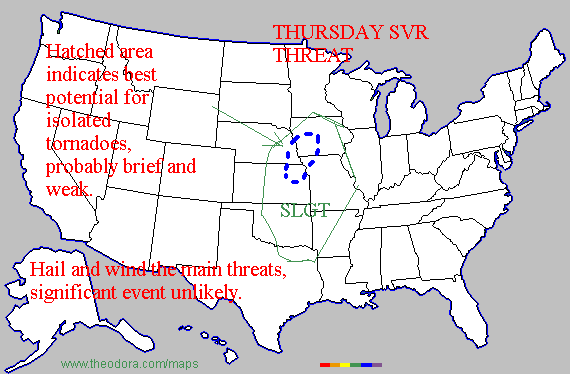
Earlier i thought the storm might go northward, but it seems more obvious now that it should track across central iowa and then into far southeastern MN by friday morning. The parameters do not appear to be in place for a severe weather outbreak. The cold front will overtake the dry line and thus any storms will be confined to the cold front and with forcing, linear/clusters of supercells are what I expect. Low topped supercell tornadoes are possible in the hatched areas, but like i said in the graphic they should be brief, weak tornadoes. I am not even making a threat area for friday as I dont expect anything more than marginal wind reports and a brief weak tornado or two. Not exactly the perfect storm.
0 likes   

User avatar
Weatherfreak14
Category 5
Category 5
Posts: 1383
Joined: Sat Sep 24, 2005 3:40 pm
Location: Beaufort, SC
Contact:

#65 Postby Weatherfreak14 » Tue Mar 28, 2006 6:28 pm

Good Report, WFS. I agree but we may see, just maybe see at least one strong, long lived tornado. Maybe just one. 8-)
0 likes   

User avatar
cheezyWXguy
Category 5
Category 5
Posts: 6108
Joined: Mon Feb 13, 2006 12:29 am
Location: Dallas, TX

#66 Postby cheezyWXguy » Tue Mar 28, 2006 6:33 pm

I think ur severe weather areas are too small...check out this link...Im in the 30% part and Im down in NTX

http://www.spc.noaa.gov/products/outlook/day3otlk.html
0 likes   

CrazyC83
Professional-Met
Professional-Met
Posts: 34002
Joined: Tue Mar 07, 2006 11:57 pm
Location: Deep South, for the first time!

#67 Postby CrazyC83 » Tue Mar 28, 2006 7:21 pm

cheezywxman wrote:I think ur severe weather areas are too small...check out this link...Im in the 30% part and Im down in NTX

http://www.spc.noaa.gov/products/outlook/day3otlk.html


That's how I see it too, just even larger.
0 likes   

CrazyC83
Professional-Met
Professional-Met
Posts: 34002
Joined: Tue Mar 07, 2006 11:57 pm
Location: Deep South, for the first time!

#68 Postby CrazyC83 » Tue Mar 28, 2006 11:04 pm

NOTE: These are NOT official forecasts, just my predictions.

It seems confidence is increasing in this becoming a major event. Hence I have upgraded the threat level for Thursday one notch.

The severe weather could start tomorrow in parts of the southern Great Plains, centered around the middle Rio Grande Valley in Southwest Texas (mostly a wind and hail event):

Image

On Thursday, everything heats up. I don't know enough yet to pinpoint the threat levels or increase them, but I still believe there is a significant risk of severe weather, including many potentially strong tornadoes. I should get a better idea tomorrow:

Image

I've taken my first crack at Friday, and I think the storms will hold up farther east, but I am not completely confident yet, so I hold the risk to Level 2 for an enormous area:

Image

There is still a lot that could happen, and the risk levels could increase if the threat increases tomorrow.
0 likes   

User avatar
cheezyWXguy
Category 5
Category 5
Posts: 6108
Joined: Mon Feb 13, 2006 12:29 am
Location: Dallas, TX

#69 Postby cheezyWXguy » Wed Mar 29, 2006 8:02 am

wow...this is looking bigger than any outbreak I saw in my area last year...Im in 45% on this map...check out the link... http://www.spc.noaa.gov/products/outloo ... 00_any.gif
0 likes   

conestogo_flood
Category 5
Category 5
Posts: 1268
Joined: Wed Sep 28, 2005 5:49 pm

#70 Postby conestogo_flood » Wed Mar 29, 2006 8:41 am

On the CNN weather map for tomorrow, they got their tornado symbols up.
0 likes   

User avatar
Weatherfreak14
Category 5
Category 5
Posts: 1383
Joined: Sat Sep 24, 2005 3:40 pm
Location: Beaufort, SC
Contact:

#71 Postby Weatherfreak14 » Wed Mar 29, 2006 8:54 am

Yep this looks to be a bigger outbreak than thought.
0 likes   

User avatar
wxmann_91
Category 5
Category 5
Posts: 8013
Age: 34
Joined: Fri Jul 15, 2005 2:49 pm
Location: Southern California
Contact:

#72 Postby wxmann_91 » Wed Mar 29, 2006 10:34 am

I actually will downplay this event. Moisture is not good enough, and now we have the problem of morning convection which of course will dampen the severe prospects later in the day. Linear should be the main convective mode.

As I have stated in an earlier post, next week should be looking good for severe. That one bears watching.
0 likes   

CrazyC83
Professional-Met
Professional-Met
Posts: 34002
Joined: Tue Mar 07, 2006 11:57 pm
Location: Deep South, for the first time!

#73 Postby CrazyC83 » Wed Mar 29, 2006 11:06 am

I'm about to rewrite my forecast - and I think this will be HUGE and widespread. I still don't know why the SPC has only issued a "slight risk" with 45% probability (it should be a "moderate risk" for the 45% area).

I'm holding it at Level 3 for now, but the risk area has increased. In addition, the confidence is increasing that there will be a major outbreak. The next update (tonight) will likely increase the threat.
0 likes   

Matt-hurricanewatcher

#74 Postby Matt-hurricanewatcher » Wed Mar 29, 2006 11:16 am

So will this be as big as March 12th?
0 likes   

User avatar
WaitingForSiren
Category 1
Category 1
Posts: 383
Joined: Sun Jan 08, 2006 12:58 pm
Location: Minneapolis,Minnesota
Contact:

#75 Postby WaitingForSiren » Wed Mar 29, 2006 11:19 am

Im getting a little more concerned about the iowa/east nebraska/southern MN tornado potential for thursday afternoon and evening. Even the GFS seems to bring this thing further north now, and with that strong a low I wouldnt be surprised if we have a localized outbreak of mini supercells with tornadoes near the low and warm front. Like i said earlier, strong tornadoes are unlikely given the lack of deep moisture and probable areas of cloud cover, but this even is looking a LITTLE bigger than I earlier expected, but further north. I'll update my day 2 outlook this afternoon, and that will be my final call.
0 likes   

CrazyC83
Professional-Met
Professional-Met
Posts: 34002
Joined: Tue Mar 07, 2006 11:57 pm
Location: Deep South, for the first time!

#76 Postby CrazyC83 » Wed Mar 29, 2006 11:34 am

These are NOT official forecasts - just my predictions.

This is for today: the precursor event. It should be mostly a wind and hail event over the High Plains due to the less humid air mass there. This is the final call for today.

Image

Here's the REAL DEAL tomorrow! Confidence is increasing more and more than this will be a HUGE outbreak. However, I cannot narrow it down enough to go beyond Level 3, but the area has been enlarged.

Image

Tomorrow's prediction should be updated next late this afternoon or this evening, or sooner if major changes happen. Friday's prediction will be updated tonight.
0 likes   

User avatar
WaitingForSiren
Category 1
Category 1
Posts: 383
Joined: Sun Jan 08, 2006 12:58 pm
Location: Minneapolis,Minnesota
Contact:

#77 Postby WaitingForSiren » Wed Mar 29, 2006 11:38 am

Nice...you have me in a level 3 there=). I think thats a little overdone IMO, but who knows.
0 likes   

User avatar
wxmann_91
Category 5
Category 5
Posts: 8013
Age: 34
Joined: Fri Jul 15, 2005 2:49 pm
Location: Southern California
Contact:

#78 Postby wxmann_91 » Wed Mar 29, 2006 11:41 am

Matt-hurricanewatcher wrote:So will this be as big as March 12th?


No.

As I said, I'm not too happy about this event. Though I agree cold core will need watching. If cap breaks, southeastern OK may need watching also as directional shear is better in that area.
0 likes   

User avatar
WaitingForSiren
Category 1
Category 1
Posts: 383
Joined: Sun Jan 08, 2006 12:58 pm
Location: Minneapolis,Minnesota
Contact:

#79 Postby WaitingForSiren » Wed Mar 29, 2006 11:47 am

I expect two distinct severe areas tomorrow. One near the low, and one in the southern end of the storm. Like spc said in their day 2 outlook, systems like this usually have two areas of severe weather, due to cloud cover and instability issues. I think one area of severe will be in central/east oklahoma, southeast kansas and southern missouri into west arkansas. the next will be in east nebraska, iowa and far southern MN.
0 likes   

CrazyC83
Professional-Met
Professional-Met
Posts: 34002
Joined: Tue Mar 07, 2006 11:57 pm
Location: Deep South, for the first time!

#80 Postby CrazyC83 » Wed Mar 29, 2006 11:53 am

I tend to view my forecasts a bit differently than the SPC: a Level 3 "significant risk" would be equal to an SPC "moderate risk" since I think they downplay such.

The risk area general equivalents based on SPC risk, modified for my views:

Combined threat

5% (SPC "See text") - Level 1
15% (SPC "Slight") - Level 1
30% (SPC "Slight") - Level 2
45% (SPC "Slight" unhatched) - Level 2
45% (SPC "Moderate" hatched) - Level 3
60% (SPC "Moderate" unhatched) - Level 3 or 4
60% (SPC "High" hatched) - Level 4 or 5

Tornado threat

2% (SPC "See Text") - Level 1
5% (SPC "Slight") - Level 1 or 2
10% (SPC "Slight") - Level 2 or 3
15% (SPC "Moderate") - Level 3 or 4
30% (SPC "High") - Level 4 or 5
45% (SPC "High") - Level 5
60% (SPC "High") - Level 5

Wind Threat

5% (SPC "See Text") - Level 1
15% (SPC "Slight") - Level 1
30% (SPC "Slight") - Level 2
45% (SPC "Moderate") - Level 3
60% (SPC "Moderate" unhatched) - Level 4
60% (SPC "High" hatched) - Level 4 or 5

Hail Threat

5% (SPC "See Text") - Level 1
15% (SPC "Slight") - Level 1
30% (SPC "Slight") - Level 2
45% (SPC "Slight" unhatched) - Level 2
45% (SPC "Moderate" hatched) - Level 3
60% (SPC "Moderate") - Level 3 or 4

There are often exceptions made and I won't always follow the SPC risk area if I think it will be in a larger, smaller or different area. Also I ignore water and national borders; risk areas will extend into the Gulf, Atlantic or Pacific or into Canada or Mexico if necessary.
0 likes   


Return to “USA & Caribbean Weather”

Who is online

Users browsing this forum: No registered users and 21 guests