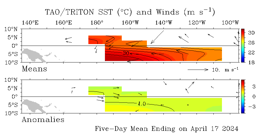
SST'S and Anomalies in Atlantic and Pacific
Moderator: S2k Moderators
Forum rules
The posts in this forum are NOT official forecasts and should not be used as such. They are just the opinion of the poster and may or may not be backed by sound meteorological data. They are NOT endorsed by any professional institution or STORM2K. For official information, please refer to products from the National Hurricane Center and National Weather Service.
I don't know if this has been mentioned before.. but beware of taking any heart in SST anomalies that happen on a daily basis. Too much can happen from day to day that doesn't give any real representation of what is occurring.. more like noise for sure. I would take a longer average... at least a week... to get a sense of what is really going on. For example, the Madden-Julian Oscillation is well-known to change wind/pressure patterns and affect SSTs in that way. For that reason I would typically recommend averaging over the past month (anomaly-wise) to get a real sense of what is happening. The shelf waters in the GOM warm up no matter what is happening with fronts... the sun angle gets brutal in the next month or two. I expect the monday weekly SST analyses to show some warming in the tropical Atlantic Ocean... which is the area to watch for those who like tropical cyclones 
As far as La Nina goes.. it has weakened some over the past month.. they typically do at this time of the year as the sun moves directly over the equator and has a tendency to warm the waters no matters what. i think once the southern pacific itcz goes away in late april it may start to cool again (because then the enhanced trades would flow straight to the n pacific itcz rather than being cutoff to the south). that is just speculation though as i haven't seen any research there.
As far as La Nina goes.. it has weakened some over the past month.. they typically do at this time of the year as the sun moves directly over the equator and has a tendency to warm the waters no matters what. i think once the southern pacific itcz goes away in late april it may start to cool again (because then the enhanced trades would flow straight to the n pacific itcz rather than being cutoff to the south). that is just speculation though as i haven't seen any research there.
0 likes
- cycloneye
- Admin

- Posts: 149518
- Age: 69
- Joined: Thu Oct 10, 2002 10:54 am
- Location: San Juan, Puerto Rico

The Weak La Nina looks a little bit smaller in area coverage than in the past 2 weeks especially west of 160w at el nino 4 area.
0 likes
Visit the Caribbean-Central America Weather Thread where you can find at first post web cams,radars
and observations from Caribbean basin members Click Here
and observations from Caribbean basin members Click Here
- cycloneye
- Admin

- Posts: 149518
- Age: 69
- Joined: Thu Oct 10, 2002 10:54 am
- Location: San Juan, Puerto Rico
http://www.ndbc.noaa.gov/station_page.php?station=41101
Waters are warming up (80 F+) east of the Lesser Antilles west of 50w around 14n where this bouy is located.
Waters are warming up (80 F+) east of the Lesser Antilles west of 50w around 14n where this bouy is located.
0 likes
-
JonathanBelles
- Professional-Met

- Posts: 11430
- Age: 35
- Joined: Sat Dec 24, 2005 9:00 pm
- Location: School: Florida State University (Tallahassee, FL) Home: St. Petersburg, Florida
- Contact:
- cycloneye
- Admin

- Posts: 149518
- Age: 69
- Joined: Thu Oct 10, 2002 10:54 am
- Location: San Juan, Puerto Rico

The latest update of the Atlantic anomalies show a warming trend and that is expected as the sun angle is everyday higher.THe only area that has cooler anomalies is the Western Atlantic east of the U.S coast.
0 likes
Visit the Caribbean-Central America Weather Thread where you can find at first post web cams,radars
and observations from Caribbean basin members Click Here
and observations from Caribbean basin members Click Here
-
Scorpion
-
Weatherfreak000
- HouTXmetro
- Category 5

- Posts: 3949
- Joined: Sun Jun 13, 2004 6:00 pm
- Location: District of Columbia, USA
-
MiamiensisWx
-
MiamiensisWx
Who is online
Users browsing this forum: Ulf and 97 guests


