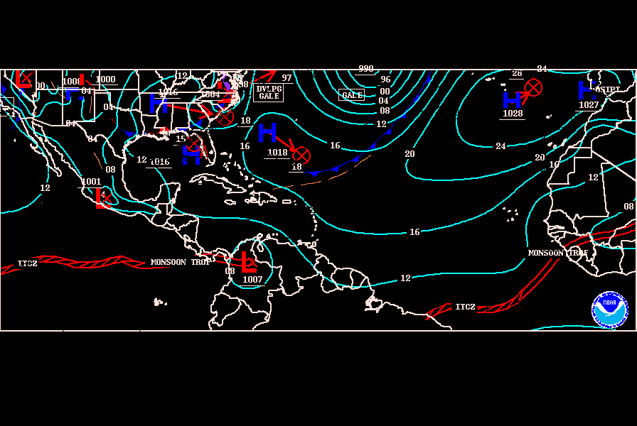
SST'S and Anomalies in Atlantic and Pacific

This is the general tropical discussion area. Anyone can take their shot at predicting a storms path.

Moderator: S2k Moderators

Forum rules

The posts in this forum are NOT official forecasts and should not be used as such. They are just the opinion of the poster and may or may not be backed by sound meteorological data. They are NOT endorsed by any professional institution or STORM2K. For official information, please refer to products from the National Hurricane Center and National Weather Service.

Help Support Storm2K
Message
Author
User avatar
gatorcane
S2K Supporter
S2K Supporter
Posts: 23693
Age: 47
Joined: Sun Mar 13, 2005 3:54 pm
Location: Boca Raton, FL

#761 Postby gatorcane » Thu Apr 06, 2006 8:09 pm

those are not temperatures meteorologyman - that is vertical wind shear.
0 likes   

meteorologyman
Category 2
Category 2
Posts: 541
Joined: Wed Mar 15, 2006 6:48 pm
Location: Florida, Kissimmee/St.CLoud

#762 Postby meteorologyman » Thu Apr 06, 2006 8:22 pm

Found something this is Feburary SST top is 2006 bottom is 2005

http://www.wunderground.com/blog/natema ... amp=200603

Let me see if I can find one for this month
0 likes   

User avatar
skysummit
S2K Supporter
S2K Supporter
Posts: 5305
Age: 49
Joined: Tue Aug 31, 2004 11:09 pm
Location: Ponchatoula, LA
Contact:

#763 Postby skysummit » Thu Apr 06, 2006 9:48 pm

SST plots for 04/06 21Z.....still warm. I looked at every hour and there's not much change in temps. Where it's in the 80's, it stays in the 80's day and night. :( I believe that 90 degree mark near the Yucatan is a fluke reading...or at least I hope it is!

Image
0 likes   

HurricaneHunter914
Category 5
Category 5
Posts: 4439
Age: 31
Joined: Fri Mar 10, 2006 7:36 pm
Location: College Station, TX

#764 Postby HurricaneHunter914 » Thu Apr 06, 2006 10:04 pm

The caribbean is HOT, HOT, HOT. If a storm goes into there while shear is low it will BOMB, BOMB, and BOMB.
0 likes   

CHRISTY

#765 Postby CHRISTY » Thu Apr 06, 2006 10:50 pm

Imagine this setup in august or september!

Image
0 likes   

User avatar
gatorcane
S2K Supporter
S2K Supporter
Posts: 23693
Age: 47
Joined: Sun Mar 13, 2005 3:54 pm
Location: Boca Raton, FL

#766 Postby gatorcane » Thu Apr 06, 2006 10:59 pm

The caribbean is HOT, HOT, HOT. If a storm goes into there while shear is low it will BOMB, BOMB, and BOMB


That is a bit simplistic. There are so many factors to consider one of which is wind shear. Also, the temps are normal or even a tad below normal for this time of year. Nothing to be surprised at.

The Caribbean will always be warm, year after year. We should look at at some of the other areas in the Atlantic Basin that vary from year to year. As you can see by the map below, it looks like many areas of the Atantic Basin are actually running above normal...

Image
0 likes   

Weatherfreak000

#767 Postby Weatherfreak000 » Thu Apr 06, 2006 11:18 pm

Woah, looks like the first of the Orange is finally showing up a bit.


Getting interesting out there.
0 likes   

User avatar
Hurricaneman
Category 5
Category 5
Posts: 7391
Age: 45
Joined: Tue Aug 31, 2004 3:24 pm
Location: central florida

#768 Postby Hurricaneman » Thu Apr 06, 2006 11:36 pm

skysummit wrote:SST plots for 04/06 21Z.....still warm. I looked at every hour and there's not much change in temps. Where it's in the 80's, it stays in the 80's day and night. :( I believe that 90 degree mark near the Yucatan is a fluke reading...or at least I hope it is!

Image

I hope that the temperature reading off of the yucatan is a data glitch, or thats a really bad sign
0 likes   

CHRISTY

#769 Postby CHRISTY » Fri Apr 07, 2006 12:35 am

Image
0 likes   

CHRISTY

#770 Postby CHRISTY » Fri Apr 07, 2006 12:40 am

Image
0 likes   

User avatar
benny
Category 2
Category 2
Posts: 593
Joined: Sun Mar 19, 2006 8:09 am
Location: Miami

#771 Postby benny » Fri Apr 07, 2006 9:28 am

The 90F reading is probably a drifting buoy in just a few feet of water that has been beached.. you see that a lot.. look at the diurnal variation to confirm.. if it varies more than a degree or two... ?!??!
0 likes   

User avatar
benny
Category 2
Category 2
Posts: 593
Joined: Sun Mar 19, 2006 8:09 am
Location: Miami

#772 Postby benny » Fri Apr 07, 2006 9:28 am

In fact you can see the same thing off the w coast of Guatemala... beached buoy!
0 likes   

meteorologyman
Category 2
Category 2
Posts: 541
Joined: Wed Mar 15, 2006 6:48 pm
Location: Florida, Kissimmee/St.CLoud

#773 Postby meteorologyman » Fri Apr 07, 2006 2:31 pm

ERIKA I FOUND IT

this is the website that will show SST from January 1992 all the to this day

http://www.imcs.rutgers.edu/cool/sat_da ... nothumbs=0

however some images are bad or hard to read
0 likes   

User avatar
benny
Category 2
Category 2
Posts: 593
Joined: Sun Mar 19, 2006 8:09 am
Location: Miami

#774 Postby benny » Fri Apr 07, 2006 5:09 pm

old SSTs are also at http://www.cdc.noaa.gov/composite/

if you choose Renanalysis SST and surface it should work..
0 likes   

User avatar
skysummit
S2K Supporter
S2K Supporter
Posts: 5305
Age: 49
Joined: Tue Aug 31, 2004 11:09 pm
Location: Ponchatoula, LA
Contact:

#775 Postby skysummit » Fri Apr 07, 2006 5:31 pm

Today's 20Z SST Plot. Notice the data just off the Yucatan...today it's 91! That's one hot beached buoy! Hopefully it's beached!

Image
0 likes   

HurricaneHunter914
Category 5
Category 5
Posts: 4439
Age: 31
Joined: Fri Mar 10, 2006 7:36 pm
Location: College Station, TX

#776 Postby HurricaneHunter914 » Fri Apr 07, 2006 6:02 pm

The GOM and the Atlantic is warming up though if the ridge wasn't here it would have been warmer from what I've heard.
0 likes   

User avatar
cycloneye
Admin
Admin
Posts: 146203
Age: 69
Joined: Thu Oct 10, 2002 10:54 am
Location: San Juan, Puerto Rico

#777 Postby cycloneye » Fri Apr 07, 2006 7:00 pm

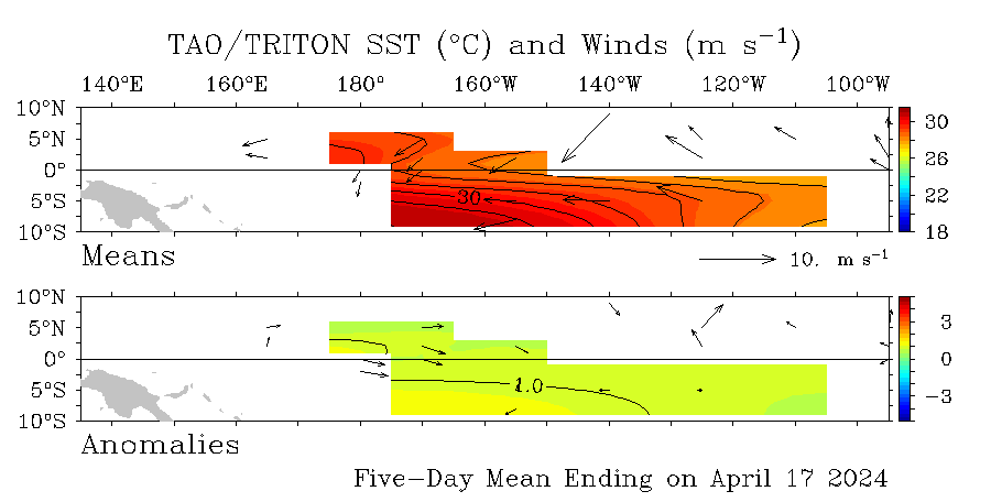
The weak La Nina looks more weaker now than in the past week.The question is if this trend of weakening and tilting to Neutral will materilize more earlier than thought or these are fluctuations.
Image
0 likes   
Visit the Caribbean-Central America Weather Thread where you can find at first post web cams,radars
and observations from Caribbean basin members Click Here

User avatar
tailgater
S2K Supporter
S2K Supporter
Posts: 3339
Joined: Sun Jul 11, 2004 9:13 pm
Location: St. Amant La.

#778 Postby tailgater » Fri Apr 07, 2006 7:35 pm

tailgater wrote:
tailgater wrote:
cycloneye wrote:Image

David disturbing the word that you used is the right one to describe how the GOM is right now in terms of the sst's and ssta's.


bump
bump
Temps cooled a little this week and last but warming again in N. gulf.

bump
0 likes   

HurricaneHunter914
Category 5
Category 5
Posts: 4439
Age: 31
Joined: Fri Mar 10, 2006 7:36 pm
Location: College Station, TX

#779 Postby HurricaneHunter914 » Fri Apr 07, 2006 7:41 pm

this thread really doesn't need a bump.
0 likes   

User avatar
tailgater
S2K Supporter
S2K Supporter
Posts: 3339
Joined: Sun Jul 11, 2004 9:13 pm
Location: St. Amant La.

#780 Postby tailgater » Sat Apr 08, 2006 9:29 am

Hurricane Hunter 914 wrote:this thread really doesn't need a bump.

This chart is the best one for the GOM, FLA coast and NW carribean( SST's). It updates every day, and it's hard to find if left to the abyss of this thread.
0 likes   


Return to “Talkin' Tropics”

Who is online

Users browsing this forum: Google [Bot], Kazmit, MetroMike, tolakram and 39 guests