Possible tropical System Forming in the Bahamas?

This is the general tropical discussion area. Anyone can take their shot at predicting a storms path.

Moderator: S2k Moderators

Forum rules

The posts in this forum are NOT official forecasts and should not be used as such. They are just the opinion of the poster and may or may not be backed by sound meteorological data. They are NOT endorsed by any professional institution or STORM2K. For official information, please refer to products from the National Hurricane Center and National Weather Service.

Help Support Storm2K
Message
Author
User avatar
SouthFloridawx
S2K Supporter
S2K Supporter
Posts: 8346
Age: 46
Joined: Tue Jul 26, 2005 1:16 am
Location: Sarasota, FL
Contact:

#81 Postby SouthFloridawx » Sun Apr 09, 2006 8:08 pm

benny wrote:Someone needs to throw the -removed- flag on this thread! If the upper trough were forecast by any model to cut off... it would be interesting. However all models forecast this trough at 200 mb to remain solid so the tropical chances seems like zilch. Even subtropical... usually you want the upper trough diminishing with time and ridging forming around the center... I don't see any evidence. I just hope it gives us some rain! :P


I don't see where anyone is wonderful forcasting on this topic. The nws said that there was a chance for subtopical development into south florida. So we'll wait and see if this happens. I also hope for more rain from this system.
0 likes   

User avatar
HURAKAN
Professional-Met
Professional-Met
Posts: 46086
Age: 38
Joined: Thu May 20, 2004 4:34 pm
Location: Key West, FL
Contact:

#82 Postby HURAKAN » Sun Apr 09, 2006 8:16 pm

SouthFloridawx wrote:
benny wrote:Someone needs to throw the -removed- flag on this thread! If the upper trough were forecast by any model to cut off... it would be interesting. However all models forecast this trough at 200 mb to remain solid so the tropical chances seems like zilch. Even subtropical... usually you want the upper trough diminishing with time and ridging forming around the center... I don't see any evidence. I just hope it gives us some rain! :P


I don't see where anyone is wonderful forcasting on this topic. The nws said that there was a chance for subtopical development into south florida. So we'll wait and see if this happens. I also hope for more rain from this system.


I agree. I myself try to keep my arguments from not being a wishcast, but just reasonable thinking. The NWS is talking about a possible low developing SE of Florida over the Bahamas, and our 2 most reliable computer models, NOGAPS and GFS, are forecasting that something may happen in the Bahamas. Of course, I agree that it's very unlikely given the time of the year and climatology, for a tropical cyclone, or even a subtropical cyclone to develop. Nevertheless, it's just an area to keep an eye. Just remember that during the hurricane season we have lots of areas that are possible subjects to development and only a few develop. Maybe a low will form and nothing else happens, maybe not. No one has to hesitate but just keep an eye on the Bahamas over the next few days.
0 likes   

CHRISTY

#83 Postby CHRISTY » Sun Apr 09, 2006 9:08 pm

nogaps show something to the south of florida in 144 HRS....seems rather weak but still interesting!lets see if this continues with future runs...


Image
0 likes   

User avatar
Tampa Bay Hurricane
Category 5
Category 5
Posts: 5597
Age: 37
Joined: Fri Jul 22, 2005 7:54 pm
Location: St. Petersburg, FL

#84 Postby Tampa Bay Hurricane » Sun Apr 09, 2006 9:13 pm

low pressure area...hmm interesting...even though unlikely...very interesting nonetheless
0 likes   

User avatar
benny
Category 2
Category 2
Posts: 593
Joined: Sun Mar 19, 2006 8:09 am
Location: Miami

#85 Postby benny » Sun Apr 09, 2006 9:23 pm

HURAKAN wrote:
SouthFloridawx wrote:
benny wrote:Someone needs to throw the -removed- flag on this thread! If the upper trough were forecast by any model to cut off... it would be interesting. However all models forecast this trough at 200 mb to remain solid so the tropical chances seems like zilch. Even subtropical... usually you want the upper trough diminishing with time and ridging forming around the center... I don't see any evidence. I just hope it gives us some rain! :P


I don't see where anyone is wonderful forcasting on this topic. The nws said that there was a chance for subtopical development into south florida. So we'll wait and see if this happens. I also hope for more rain from this system.


I agree. I myself try to keep my arguments from not being a wishcast, but just reasonable thinking. The NWS is talking about a possible low developing SE of Florida over the Bahamas, and our 2 most reliable computer models, NOGAPS and GFS, are forecasting that something may happen in the Bahamas. Of course, I agree that it's very unlikely given the time of the year and climatology, for a tropical cyclone, or even a subtropical cyclone to develop. Nevertheless, it's just an area to keep an eye. Just remember that during the hurricane season we have lots of areas that are possible subjects to development and only a few develop. Maybe a low will form and nothing else happens, maybe not. No one has to hesitate but just keep an eye on the Bahamas over the next few days.


First of all, if we are talking about tropical or subtropical development... the front has to totally disappear. This will take days. Whatever melbourne said is really irrelevant as i don't think they understand the definition of subtropical cyclone. Of course they know what it is but any model field from any model shows extratropical with little hint of a warm core. Of course everyone looks at the disturbed weather with all the tstms.. but is there any reason to think this will have subtropical characteristics at all? I see shear greater than 30 kt forecast, I see a 1000-850 mb thickness gradient across the low development... not a good chance for anything remotely like a ST. That's just my opinion of course... :P
0 likes   

CHRISTY

#86 Postby CHRISTY » Sun Apr 09, 2006 9:30 pm

The gfs (scroll right & click forward) is being most persistant about a TD forming around Bahamas.

Image

HERE'S THE LINK...http://moe.met.fsu.edu/cgi-bin/gfstc2.cgi?time=2006040906&field=850mb+Vorticity&hour=Animation
0 likes   

Steve H.
Category 5
Category 5
Posts: 2149
Joined: Sat Oct 19, 2002 9:06 am
Location: Palm Bay, Florida

#87 Postby Steve H. » Sun Apr 09, 2006 9:56 pm

Don't slam the mets in Melbourne Florida, they are some of the best in the country. I believe they may know a wee little bit more about tropical systems than anyone on this board. Besides, they need to get their skills sharpened for what I belive may be another nightmare of a season in the sunshine state. :eek:
0 likes   

User avatar
Tampa Bay Hurricane
Category 5
Category 5
Posts: 5597
Age: 37
Joined: Fri Jul 22, 2005 7:54 pm
Location: St. Petersburg, FL

#88 Postby Tampa Bay Hurricane » Sun Apr 09, 2006 10:00 pm

My earlier predicitions ignored melborne nws-- I need to take that into account
After reading the discussion...I feel the potential exists for a strong low pressure area to form and possibly become subtropical...the chance is slight but it's still a decent chance for April...very unusual activity for April...possibly a weak subtropical storm off the FL east coast not out of the question

of course if I am wrong I'll eat my crow happily...I'm not rooting for any storms...
0 likes   

Rainband

#89 Postby Rainband » Sun Apr 09, 2006 10:12 pm

Not Likely to happen.
0 likes   

CHRISTY

#90 Postby CHRISTY » Sun Apr 09, 2006 10:15 pm

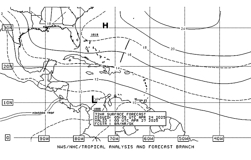
Even the NHC has a trough with low pressures in the Carribean in 72 hours...

Image[/url]
0 likes   

CHRISTY

#91 Postby CHRISTY » Sun Apr 09, 2006 10:21 pm

The newest GFS is more bullish on the system going warm core, but only shallow at best. This is probably because the SST are right around the 80 degree threshold for tropical cyclones. The GFS also takes 3 days before killing the system off.

here's the link to the GFS...

http://moe.met.fsu.edu/cyclonephase/gfs/fcst/archive/06040918/54.html

A TD AT BEST!
0 likes   

User avatar
HURAKAN
Professional-Met
Professional-Met
Posts: 46086
Age: 38
Joined: Thu May 20, 2004 4:34 pm
Location: Key West, FL
Contact:

#92 Postby HURAKAN » Sun Apr 09, 2006 10:31 pm

Rainband wrote:Not Likely to happen.


Climatologically speaking, nothing in April is suppose to happen in the tropics.
0 likes   

CHRISTY

#93 Postby CHRISTY » Sun Apr 09, 2006 10:36 pm

HURAKAN wrote:
Rainband wrote:Not Likely to happen.


Climatologically speaking, nothing in April is suppose to happen in the tropics.
yea thats true but after last years 27 storms it would not surprise me....
0 likes   

User avatar
boca
Category 5
Category 5
Posts: 6372
Age: 60
Joined: Mon Dec 15, 2003 8:49 am
Location: Boca Raton,FL

#94 Postby boca » Sun Apr 09, 2006 10:45 pm

Look in the Eastern Gulf about 200 miles WSW of Ft Myers. This could be the beginning of what the GFS was saying. I don't think it will be tropical due to water temps and shear but low presure yes. It is seperate from the trough over Florida.

http://www.ssd.noaa.gov/PS/TROP/DATA/RT ... -loop.html
0 likes   

User avatar
Incident_MET
Professional-Met
Professional-Met
Posts: 63
Joined: Tue Mar 28, 2006 10:22 pm
Location: Floridana Beach, FL

#95 Postby Incident_MET » Sun Apr 09, 2006 10:50 pm

Hey Benny...you need to look back at earlier discussions pasted to this subject thread. You will see none were listed from Melbourne. Read before flaming. Thank you.
0 likes   

User avatar
vbhoutex
Storm2k Executive
Storm2k Executive
Posts: 29114
Age: 73
Joined: Wed Oct 09, 2002 11:31 pm
Location: Cypress, TX
Contact:

#96 Postby vbhoutex » Sun Apr 09, 2006 11:13 pm

Benny, your statement against NWS-Melbourne is unwarranted, unacceptable on this site and can not be backed up. The NWS-Melbourne office is well known for their Tropical expertise. That can be backed up!!! FYI, a few of the forecasters from that office are members here. Think before you post please. We do not allow bashing at this site.
0 likes   

User avatar
benny
Category 2
Category 2
Posts: 593
Joined: Sun Mar 19, 2006 8:09 am
Location: Miami

#97 Postby benny » Mon Apr 10, 2006 12:43 am

My apologies to the melbourne office. The office that issued was jacksonville, not melbourne. It doesn't change my point though. subtropical is not the correct term to use here and that adds to confusion. i didn't mean they don't understand the definition, it was just incorrectly used in this meteorological situation. i should have read that one more time before i posted.
0 likes   

User avatar
skysummit
S2K Supporter
S2K Supporter
Posts: 5305
Age: 49
Joined: Tue Aug 31, 2004 11:09 pm
Location: Ponchatoula, LA
Contact:

#98 Postby skysummit » Mon Apr 10, 2006 10:05 am

Is there something off of Florida right now? It looks like the showers are rotating just just off of Miami.

Image
0 likes   

User avatar
weatherwoman132
Category 1
Category 1
Posts: 305
Joined: Wed Mar 08, 2006 7:26 pm

#99 Postby weatherwoman132 » Mon Apr 10, 2006 10:09 am

I think there is a low in place which is making the showers stay around
0 likes   

User avatar
gatorcane
S2K Supporter
S2K Supporter
Posts: 23694
Age: 47
Joined: Sun Mar 13, 2005 3:54 pm
Location: Boca Raton, FL

#100 Postby gatorcane » Mon Apr 10, 2006 10:11 am

There is no mention of any low whatsoever by the NWS Miami. Just a stalled out frontal boundary and convergence:

000
FXUS62 KMFL 101420
AFDMFL

AREA FORECAST DISCUSSION
NATIONAL WEATHER SERVICE MIAMI FL
1020 AM EDT MON APR 10 2006

.UPDATE...THE MORNING MIAMI SOUNDING IS STILL UNSTABLE...BUT NOT
AS UNSTABLE AS YESTERDAY. ALTHOUGH THE H5 TEMP IS COLDER THAN
24 HRS AGO...AT -13.1C...THE ATMOSPHERE HAS COOLED AT THE SURFACE AND
LOWER LEVELS...COMPENSATING FOR THE COLDER MID LEVEL AIR.
STILL...IT IS UNSTABLE...AS THE MODIFIED MIA SOUNDING FOR EXPECTED
AFTERNOON MAXES YIELDS A CAPE OF 2500 J/KG...LI OF -7C...AND A
K-INDEX OF 30. ALTHOUGH BEST CONVERGENCE IS SOUTHEAST OF THE AREA
ALONG THE SURFACE FRONT...EXPECT THIS UNSTABLE AIRMASS TO ALLOW
FOR SCT-NUM SHOWERS AND ISOLATED THUNDERSTORMS TO AFFECT THE
ATLANTIC COAST...DUE TO COASTAL CONVERGENCE IN THE STRENGTHENING
NE FLOW. SOME OF THIS ACTIVITY...AS SHOWN BY THE WRF...MAY MOVE
ACROSS THE PENINSULA AND/OR DEVELOP ESPECIALLY LATE THIS AFTERNOON
AS THE NE FLOW STRENGTHENS. UPDATED THE FORECAST ONLY TO INCREASE
POPS INTO THE LIKELY CATEGORY EAST COAST ZONES. WET BULB ZERO
HEIGHT IS BELOW 10K FT...SO ANY OF THE STORMS THAT DEVELOP THIS
AFTERNOON COULD CONTAIN SMALL HAIL...SO WE WILL UPDATE THE HWO TO
REFLECT THIS POSSIBILITY. /DG

&&

.PREV DISCUSSION...
DISCUSSION...FRONTAL BOUNDARY DRIFTING SOUTHEAST ACROSS SOUTHEAST
FLORIDA WHERE CONVECTION HAS BEEN FIRING UP MOST OF THE LATE NIGHT
AND EARLY MORNING HOURS. SOME OF THE INTENSE STORMS OVER WATER
PROMPTED SEVERAL SPECIAL MARINE WARNINGS. MODELS WANT TO STALL
THIS BOUNDARY ACROSS OUR AREA TODAY AND TONIGHT WHILE AT THE SAME
TIME THE UPPER TROUGH MOVES EAST ACROSS THE PENINSULA THIS
AFTERNOON AND EVENING BRINGING COOLER AIR ALOFT AND FURTHER
DESTABILIZING THE LOCAL ATMOSPHERE. AN INCREASING NORTHEAST LOW
LEVEL FLOW NORTH OF THE BOUNDARY WILL ALSO ENHANCE LOW LEVEL
CONVERGENCE ACROSS THE AREA. DECIDED TO INCREASE POPS FOR
TODAY...ESPECIALLY ACROSS MIAMI-DADE/BROWARD COUNTIES TO ACCOUNT
MORE THIS.

A SURFACE HIGH PRESSURE RIDGE OVER EASTERN U.S. WILL MOVE EAST
OVER THE WESTERN ATLANTIC TONIGHT AND AS IT DOES SO THE PRESSURE
GRADIENT WILL TIGHTEN WHICH IN TURN WILL RESULT IN INCREASING NE
WINDS (AS MENTIONED ABOVE). THIS WILL NOT ONLY ENHANCE LOW LEVEL
CONVERGENCE BUT WILL ALSO HELP TO ADVECT LOW LEVEL MOISTURE/LEFT
OVER CONVECTION BACK WEST TO SOUTH FLORIDA. SO, EVEN THOUGH, WILL
GRADUALLY DECREASE POPS, WILL KEEP AT LEAST A SLIGHT CHANCE AT
LEAST THROUGH WEDNESDAY.

MARINE...AS MENTION BEFORE...PRESSURE GRADIENT WILL TIGHTEN
ACROSS SOUTH FLORIDA`S WATERS AND SO SFC WINDS WILL INCREASE TO 20
TO 25 KTS WITH HIGHER GUSTS AS EARLY AS THIS AFTERNOON OVER THE
NORTHERN ATLANTIC WATERS...LAKE OKEECHOBEE AND PORTIONS OF THE
GULF WATERS. A SMALL CRAFT ADVISORY IS NOW IN EFFECT FOR THOSE
WATERS. THESE STRONG NORTHEAST WINDS ALONG WITH VERY ROUGH SEAS
SHOULD CONTINUE TO AFFECT THE ATLANTIC WATERS AT LEAST THROUGH
TUESDAY NIGHT WITH A SLIGHT IMPROVEMENT ON WEDNESDAY.

FIRE WEATHER...NO CONCERNS AT THIS TIME.

EXTENDED FORECAST...ATLANTIC RIDGE WILL CONTINUE TO ADVECT LOW
LEVEL MOISTURE WEST THROUGH THE ENTIRE EXTENDED PERIOD...SO WILL KEEP
SLIGHT CHANCE OF SHOWERS IN THE FORECAST THROUGH DAY SEVEN.

&&

.MFL WATCHES/WARNINGS/ADVISORIES...
FL...NONE.
AM...SMALL CRAFT ADVISORY UNTIL 6 PM EDT THIS AFTERNOON FOR COASTAL
WATERS FROM DEERFIELD BEACH TO OCEAN REEF, FL OUT 20 NM-
COASTAL WATERS FROM JUPITER INLET TO DEERFIELD BEACH, FL
OUT 20 NM-LAKE OKEECHOBEE-WATERS FROM DEERFIELD BEACH TO
OCEAN REEF, FL EXTENDING FROM 20 NMTO THE TERRITORIAL
WATERS OF THE BAHAMAS-WATERS FROM JUPITER INLET TO
DEERFIELD BEACH, FL EXTENDING FROM 20 NM TO 60 NM.

GM...SMALL CRAFT ADVISORY UNTIL 6 PM EDT THIS AFTERNOON FOR COASTAL
WATERS FROM CHOKOLOSKEE TO BONITA BEACH, FL OUT 20 NM-GULF
WATERS FROM CHOKOLOSKEE TO BONITA BEACH, FL EXTENDING FROM
20 TO 60 NM.

&&

$$

57
0 likes   


Return to “Talkin' Tropics”

Who is online

Users browsing this forum: No registered users and 62 guests