SST'S and Anomalies in Atlantic and Pacific

This is the general tropical discussion area. Anyone can take their shot at predicting a storms path.

Moderator: S2k Moderators

Forum rules

The posts in this forum are NOT official forecasts and should not be used as such. They are just the opinion of the poster and may or may not be backed by sound meteorological data. They are NOT endorsed by any professional institution or STORM2K. For official information, please refer to products from the National Hurricane Center and National Weather Service.

Help Support Storm2K
Message
Author
User avatar
cycloneye
Admin
Admin
Posts: 146192
Age: 69
Joined: Thu Oct 10, 2002 10:54 am
Location: San Juan, Puerto Rico

#841 Postby cycloneye » Sun Apr 09, 2006 7:49 pm

Image

CapeVerdeWave here it is.
0 likes   

User avatar
benny
Category 2
Category 2
Posts: 593
Joined: Sun Mar 19, 2006 8:09 am
Location: Miami

#842 Postby benny » Sun Apr 09, 2006 9:25 pm

Interesting to see the warm pool rebuilding... me thinks there will be an El Nino in a year or so as we probably can stave it off one more year.
0 likes   

CHRISTY

#843 Postby CHRISTY » Sun Apr 09, 2006 9:57 pm

gulf of mexico sea surface temps in 120 HRS....

Image
0 likes   

User avatar
Tampa Bay Hurricane
Category 5
Category 5
Posts: 5597
Age: 37
Joined: Fri Jul 22, 2005 7:54 pm
Location: St. Petersburg, FL

#844 Postby Tampa Bay Hurricane » Sun Apr 09, 2006 10:02 pm

cold off the fl west coast- quite cool

warm in the loop current...

The northwest Caribbean looks very warm...yikes...gotta start watching closely from June...
0 likes   

User avatar
windycity
S2K Supporter
S2K Supporter
Posts: 461
Joined: Wed Aug 24, 2005 6:45 pm
Location: P.B.county,Fl.
Contact:

#845 Postby windycity » Mon Apr 10, 2006 8:13 am

The nw caribbean is a bathtub now, what is it going to look like come summer? :(
0 likes   

User avatar
skysummit
S2K Supporter
S2K Supporter
Posts: 5305
Age: 49
Joined: Tue Aug 31, 2004 11:09 pm
Location: Ponchatoula, LA
Contact:

#846 Postby skysummit » Mon Apr 10, 2006 8:36 am

windycity wrote:The nw caribbean is a bathtub now, what is it going to look like come summer? :(


You'll probably literally see the bubbles from the air. Maybe the Hurricane Hunters will be able to drop eggs in the water to boil and pick them up on the way back?
0 likes   

User avatar
weatherwoman132
Category 1
Category 1
Posts: 305
Joined: Wed Mar 08, 2006 7:26 pm

#847 Postby weatherwoman132 » Mon Apr 10, 2006 8:39 am

lmao. :A:
0 likes   

User avatar
skysummit
S2K Supporter
S2K Supporter
Posts: 5305
Age: 49
Joined: Tue Aug 31, 2004 11:09 pm
Location: Ponchatoula, LA
Contact:

#848 Postby skysummit » Mon Apr 10, 2006 8:46 am

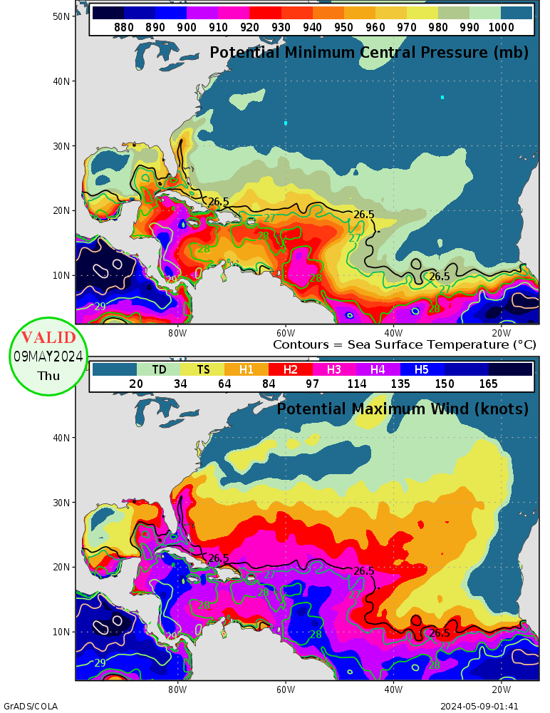
I remember a week or so ago this image was posted and the Central and Northern Gulf could hold a Cat 1 or 2. Now parts of the GOM could support a Cat 4 and now a Cat 2 all the way to the SELA coast. Also, look at the waters just off SE Florida...Cat 3. It's definately getting warmer down there and this warming trend this week will only aid.

Image
0 likes   

User avatar
windycity
S2K Supporter
S2K Supporter
Posts: 461
Joined: Wed Aug 24, 2005 6:45 pm
Location: P.B.county,Fl.
Contact:

#849 Postby windycity » Mon Apr 10, 2006 8:59 am

I hear ya. Scary, sobbering, thoughts. Now lets see what upper level winds will be doing 2 months from now. :roll: :roll:
0 likes   

User avatar
windycity
S2K Supporter
S2K Supporter
Posts: 461
Joined: Wed Aug 24, 2005 6:45 pm
Location: P.B.county,Fl.
Contact:

#850 Postby windycity » Mon Apr 10, 2006 9:02 am

And by the way , skysummit, great charts!!!! :P
0 likes   

User avatar
benny
Category 2
Category 2
Posts: 593
Joined: Sun Mar 19, 2006 8:09 am
Location: Miami

#851 Postby benny » Mon Apr 10, 2006 10:28 am

For those that like ENSO analog yers, CPC has a list of comparison of years that most resemble this ENSO cycle at: http://www.cdc.noaa.gov/people/klaus.wo ... comparison

I would post the figure but I don't know how. For the lazy.. 1961, 1985 and 1996 were the years suggested.. with 2002 being a distant fourth. :eek:
0 likes   

f5
Category 5
Category 5
Posts: 1550
Joined: Thu Aug 25, 2005 3:29 pm
Location: Waco,tx

#852 Postby f5 » Mon Apr 10, 2006 12:56 pm

skysummit wrote:I remember a week or so ago this image was posted and the Central and Northern Gulf could hold a Cat 1 or 2. Now parts of the GOM could support a Cat 4 and now a Cat 2 all the way to the SELA coast. Also, look at the waters just off SE Florida...Cat 3. It's definately getting warmer down there and this warming trend this week will only aid.

Image


i look at the pressure not the wind a 950 mb CAT 4 would have to be Charley size.that map is made for wind vs pressure relationship for a charley size storm so i just look at the pressure side of it.
0 likes   

User avatar
skysummit
S2K Supporter
S2K Supporter
Posts: 5305
Age: 49
Joined: Tue Aug 31, 2004 11:09 pm
Location: Ponchatoula, LA
Contact:

#853 Postby skysummit » Mon Apr 10, 2006 1:49 pm

Check out that little area of 80's near the loop current in the gulf. Here are today's 18Z SST Plots.

Image
0 likes   

CHRISTY

#854 Postby CHRISTY » Mon Apr 10, 2006 1:50 pm

skysummit wrote:Check out that little area of 80's near the loop current in the gulf. Here are today's 18Z SST Plots.

Image
can u post a link of that?
0 likes   

User avatar
skysummit
S2K Supporter
S2K Supporter
Posts: 5305
Age: 49
Joined: Tue Aug 31, 2004 11:09 pm
Location: Ponchatoula, LA
Contact:

#855 Postby skysummit » Mon Apr 10, 2006 1:51 pm

CHRISTY wrote:
skysummit wrote:Check out that little area of 80's near the loop current in the gulf. Here are today's 18Z SST Plots.

Image
can u post a link of that?


LOL....software too :D
0 likes   

CHRISTY

#856 Postby CHRISTY » Mon Apr 10, 2006 1:54 pm

skysummit wrote:
CHRISTY wrote:
skysummit wrote:Check out that little area of 80's near the loop current in the gulf. Here are today's 18Z SST Plots.

Image
can u post a link of that?


LOL....software too :D
u mean the $80.00 to!jesus :sadly:
0 likes   

User avatar
skysummit
S2K Supporter
S2K Supporter
Posts: 5305
Age: 49
Joined: Tue Aug 31, 2004 11:09 pm
Location: Ponchatoula, LA
Contact:

#857 Postby skysummit » Mon Apr 10, 2006 1:56 pm

No CHRISTY...it's a different software. The GRLevel3 is only radar software, however, if you get a subscription to Allisonhouse, it does have satellite overlay.
0 likes   

CHRISTY

#858 Postby CHRISTY » Mon Apr 10, 2006 2:05 pm

how can i get that....
0 likes   

User avatar
cycloneye
Admin
Admin
Posts: 146192
Age: 69
Joined: Thu Oct 10, 2002 10:54 am
Location: San Juan, Puerto Rico

#859 Postby cycloneye » Mon Apr 10, 2006 3:35 pm

Image

The above is the weekly update of the Atlantic anomalies.The cooler anomalies continue in the Western Atlantic while warmer waters are seen at parts of the MDR and Caribbean with a few smaller cooler spots scattered in the Basin.
0 likes   
Visit the Caribbean-Central America Weather Thread where you can find at first post web cams,radars
and observations from Caribbean basin members Click Here

User avatar
benny
Category 2
Category 2
Posts: 593
Joined: Sun Mar 19, 2006 8:09 am
Location: Miami

#860 Postby benny » Mon Apr 10, 2006 3:51 pm

For those that want the daily SST charts.. they do an analysis every six hours at:
http://www.coolwx.com/buoydata/

Under Maps/Analyses on the left. Just have to know your C to F conversion :)
0 likes   


Return to “Talkin' Tropics”

Who is online

Users browsing this forum: No registered users and 42 guests