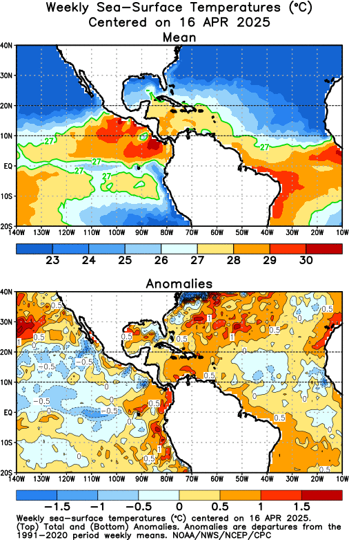
SST'S and Anomalies in Atlantic and Pacific

This is the general tropical discussion area. Anyone can take their shot at predicting a storms path.

Moderator: S2k Moderators

Forum rules

The posts in this forum are NOT official forecasts and should not be used as such. They are just the opinion of the poster and may or may not be backed by sound meteorological data. They are NOT endorsed by any professional institution or STORM2K. For official information, please refer to products from the National Hurricane Center and National Weather Service.

Help Support Storm2K
Message
Author
User avatar
James
Category 5
Category 5
Posts: 1531
Joined: Tue Aug 24, 2004 10:29 am
Location: Gloucestershire, England
Contact:

#861 Postby James » Tue Apr 11, 2006 11:22 am

Image

The Atlantic certainly seems to be slowly but surely warming up. The Caribbean seems to have warmed in the last few days, and the cooler anomalies in the Western Atlantic look like they are gradually becoming less pronounced.
0 likes   

MiamiensisWx

#862 Postby MiamiensisWx » Tue Apr 11, 2006 11:24 am

Image

What are the latest subsurface Pacific SSTs/anomalies?
0 likes   

CHRISTY

#863 Postby CHRISTY » Tue Apr 11, 2006 12:48 pm

we are approaching 80 degrees in several areas like near the ucatan ,and close to puerto and close to southflorida.

Image
0 likes   

Weatherfreak000

#864 Postby Weatherfreak000 » Tue Apr 11, 2006 3:04 pm

Looks like we are finally up on the rise.
0 likes   

User avatar
SouthFloridawx
S2K Supporter
S2K Supporter
Posts: 8346
Age: 46
Joined: Tue Jul 26, 2005 1:16 am
Location: Sarasota, FL
Contact:

#865 Postby SouthFloridawx » Tue Apr 11, 2006 3:11 pm

Is there some type of graphic that shows how warm the water is at certain depths?
0 likes   

HurricaneHunter914
Category 5
Category 5
Posts: 4439
Age: 31
Joined: Fri Mar 10, 2006 7:36 pm
Location: College Station, TX

#866 Postby HurricaneHunter914 » Tue Apr 11, 2006 3:46 pm

Hopefully there will be no more cooling events for the Atlantic because it looks like a come back is appearing.
0 likes   

User avatar
benny
Category 2
Category 2
Posts: 593
Joined: Sun Mar 19, 2006 8:09 am
Location: Miami

#867 Postby benny » Tue Apr 11, 2006 4:41 pm

This is just one week of course.. but the lack of any significant high pressure in the Atlantic has really allowed the temperatures to warm. This is probably close to a maximum anomaly that we will see (a little higher next week maybe) as the high is forecast to rebuild by the weekend in the E Atlantic.


Image
0 likes   

User avatar
benny
Category 2
Category 2
Posts: 593
Joined: Sun Mar 19, 2006 8:09 am
Location: Miami

#868 Postby benny » Tue Apr 11, 2006 4:45 pm

Here is the lack of high pressure in the Atlantic during the last 30 days. Very impressive.. though not as low or as far to the south as last year.

Image
0 likes   

Scorpion

#869 Postby Scorpion » Tue Apr 11, 2006 4:49 pm

Interesting... I thought the ridge was stronger than average for this time of year.
0 likes   

User avatar
benny
Category 2
Category 2
Posts: 593
Joined: Sun Mar 19, 2006 8:09 am
Location: Miami

#870 Postby benny » Tue Apr 11, 2006 5:13 pm

Nope! I think we have some strong ridge junkies on this board :) Though it has been stronger than average right on top of Florida... I still haven't seen anything that relates spring ridge conditions to future summer hurricane tracks (but I'd be very interested in it). However there is plenty out there on spring ridging in the Atlantic and number of hurricanes later on... the less ridging, especially in the e atlc.. the better for hurricanes (upwelling/mixing/evaporation/cooling of the SSTs)
0 likes   

Scorpion

#871 Postby Scorpion » Tue Apr 11, 2006 7:47 pm

Interesting. I thought the ridge was more widespread and covered not only Florida but much of the western Atlantic. But regardless, that is good news that the ridge isnt out there. Gives the SST's ability to warm.
0 likes   

User avatar
benny
Category 2
Category 2
Posts: 593
Joined: Sun Mar 19, 2006 8:09 am
Location: Miami

#872 Postby benny » Tue Apr 11, 2006 7:51 pm

Here is a plot of the 500 mb ridge just to clarify that in general, the ridging at most levels has been wimpy over the Atlantic. A little stronger than average over Florida.. but mostly weak. Strong ridges this time of year do mean lots of wind and doesn't allow the Atlantic SSTs to destabilize. At least in the West Atlantic.. there is no sign of a strong ridge would should allow things to warm up dramatically in the next week or two... especially in the Caribbean.

Image
0 likes   

MiamiensisWx

#873 Postby MiamiensisWx » Tue Apr 11, 2006 8:55 pm

benny, the current surface map shows strong ridging; some of that may well be strong at the upper levels, too.

Image

If it isn't strong at the upper levels, it might be too early.
0 likes   

CHRISTY

#874 Postby CHRISTY » Tue Apr 11, 2006 9:01 pm

Look at this map, which shows the probability of a tropical cyclone forming:


Image
0 likes   

HurricaneHunter914
Category 5
Category 5
Posts: 4439
Age: 31
Joined: Fri Mar 10, 2006 7:36 pm
Location: College Station, TX

#875 Postby HurricaneHunter914 » Tue Apr 11, 2006 9:06 pm

Right now things don't look too good for development but once the Hurricane Season gets here we'll be seeing pink on that map.
0 likes   

User avatar
benny
Category 2
Category 2
Posts: 593
Joined: Sun Mar 19, 2006 8:09 am
Location: Miami

#876 Postby benny » Tue Apr 11, 2006 9:23 pm

CapeVerdeWave wrote:benny, the current surface map shows strong ridging; some of that may well be strong at the upper levels, too.]

If it isn't strong at the upper levels, it might be too early.


Oh I agree that today's map has a lot of high pressure, save the ne atlc near a dying cutoff low. The point is not any specific day... but a longer-term average to get an idea of the climate. Once the timescale starts to get into the monthly timeframe... you have mechanisms that are acting upon the atmosphere that aren't synoptic in nature, but more slowly-varying. These are the signals that are tough to find, but give clues on what is happening beyond synoptic noise. Day to day is of course important for any given storm.. but when you are talking about SSTs, it takes weeks to make significant changes. If we have another 30 days of below average ridging, the Atlantic will warm significantly. It might be twenty days below and ten above... this is I think is an above day. Watch what happens with the Caribbean this week.. that weak low should kill the pressure gradient across that region.. and with the weaker trades the SSTs should warm.. maybe 0.5C or so.
0 likes   

User avatar
P.K.
Professional-Met
Professional-Met
Posts: 5149
Joined: Thu Sep 23, 2004 5:57 pm
Location: Watford, England
Contact:

#877 Postby P.K. » Wed Apr 12, 2006 6:10 am

CURRENT STATUS as at 12th April 2006
Next update expected by 3rd May 2006 (two weeks after this update).

| Summary | In Brief | Details |

Summary: Pacific remains neutral. Cool phase nearly over

The recent cool phase in the Pacific, which briefly approached La Niña-like conditions, is showing signs of decay. Sea-surface temperatures have continued to warm in the central to eastern Pacific and are now close to average. More importantly, the large body of cooler than average sub-surface water in the east has contracted considerably during the past month.

Nonetheless, the SOI has continued to rise, with the latest 30-day value being about +18. In addition, cloudiness remains strongly suppressed around the date-line. While both the SOI and the cloud are continuing to show behaviour consistent with a La Niña, large-scale coupling between the Pacific atmosphere and ocean is generally weak or absent in the southern autumn.

Computer modelling predictions of Pacific temperatures mostly indicate warming over the next few seasons, with neutral conditions in the southern winter and spring. It should be noted, however, that due to the aforementioned weak large scale coupling at this time of the year, March to June is the period when predictability of future ENSO conditions is at its lowest.
0 likes   

Weatherfreak000

#878 Postby Weatherfreak000 » Wed Apr 12, 2006 7:26 am

Temperatures are gonna be near record highs here in Louisiana as high pressure is becoming parked over us and cold fronts aren't penetrating.


It looks like it's only gonna keep getting hotter in the GOM and it's getting warmer off the East Coast. Interesting to see how this is going to play out in the future.
0 likes   

User avatar
SouthFloridawx
S2K Supporter
S2K Supporter
Posts: 8346
Age: 46
Joined: Tue Jul 26, 2005 1:16 am
Location: Sarasota, FL
Contact:

#879 Postby SouthFloridawx » Wed Apr 12, 2006 11:34 am

Image
0 likes   

Coredesat

#880 Postby Coredesat » Wed Apr 12, 2006 11:57 am

Those cold anomalies east of 110W are really becoming more pronounced.
0 likes   


Return to “Talkin' Tropics”

Who is online

Users browsing this forum: LarryWx and 42 guests