Possible tropical System Forming in the Bahamas?

This is the general tropical discussion area. Anyone can take their shot at predicting a storms path.

Moderator: S2k Moderators

Forum rules

The posts in this forum are NOT official forecasts and should not be used as such. They are just the opinion of the poster and may or may not be backed by sound meteorological data. They are NOT endorsed by any professional institution or STORM2K. For official information, please refer to products from the National Hurricane Center and National Weather Service.

Help Support Storm2K
Message
Author
User avatar
SouthFloridawx
S2K Supporter
S2K Supporter
Posts: 8346
Age: 46
Joined: Tue Jul 26, 2005 1:16 am
Location: Sarasota, FL
Contact:

#181 Postby SouthFloridawx » Wed Apr 12, 2006 10:41 am

jabber wrote:
skysummit wrote:Geez...some of you people are going to go absolutely nuts when we actually have something!!!!


Yeah... its gonna be nuts when things really start popping


Jabber I see you are in boynton beach. I also live in boynton beach where abouts are you?
0 likes   

User avatar
Evil Jeremy
S2K Supporter
S2K Supporter
Posts: 5463
Age: 32
Joined: Mon Apr 10, 2006 2:10 pm
Location: Los Angeles, CA

#182 Postby Evil Jeremy » Wed Apr 12, 2006 1:10 pm

if its going to develop it should happen very soon.
0 likes   
Frances 04 / Jeanne 04 / Katrina 05 / Wilma 05 / Fay 08 / Debby 12 / Andrea 13 / Colin 16 / Hermine 16 / Matthew 16 / Irma 17

CHRISTY

#183 Postby CHRISTY » Wed Apr 12, 2006 1:14 pm

Evil Jeremy wrote:if its going to develop it should happen very soon.
alot of covection over the area but nothing seems like its going to happen soon.

Image
0 likes   

User avatar
skysummit
S2K Supporter
S2K Supporter
Posts: 5305
Age: 49
Joined: Tue Aug 31, 2004 11:09 pm
Location: Ponchatoula, LA
Contact:

#184 Postby skysummit » Wed Apr 12, 2006 1:20 pm

Evil Jeremy wrote:if its going to develop it should happen very soon.


Do you seriously believe it to be that simple?
0 likes   

MiamiensisWx

#185 Postby MiamiensisWx » Wed Apr 12, 2006 1:21 pm

I see no signs of development now yet.
0 likes   

User avatar
SouthFloridawx
S2K Supporter
S2K Supporter
Posts: 8346
Age: 46
Joined: Tue Jul 26, 2005 1:16 am
Location: Sarasota, FL
Contact:

#186 Postby SouthFloridawx » Wed Apr 12, 2006 1:21 pm

205 PM disco from the NHC.


000
AXNT20 KNHC 121810
TWDAT

TROPICAL WEATHER DISCUSSION
NWS TPC/NATIONAL HURRICANE CENTER MIAMI FL
205 PM EDT WED APR 12 2006

TROPICAL WEATHER DISCUSSION FOR NORTH AMERICA...CENTRAL
AMERICA...THE GULF OF MEXICO...THE CARIBBEAN SEA...NORTHEASTERN
SECTIONS OF SOUTH AMERICA...AND THE ATLANTIC OCEAN TO THE
AFRICAN COAST FROM THE EQUATOR TO 32N. THE FOLLOWING INFORMATION
IS BASED ON SATELLITE IMAGERY...WEATHER OBSERVATIONS...
RADAR...AND METEOROLOGICAL ANALYSIS.

BASED ON 1800 UTC SURFACE ANALYSIS AND SATELLITE IMAGERY THROUGH
1745 UTC.

...ITCZ...
ITCZ 8N10W 4N20W 2N30W...TO THE EQUATOR AT 40W...TO 2S45W.
WIDELY SCATTERED TO SCATTERED MODERATE SHOWERS/ISOLATED STRONG
THUNDERSTORMS ARE FOUND FROM 3S TO 6N BETWEEN 30W AND 53W...OVER
LAND AND IN THE ATLANTIC WATERS. ISOLATED MODERATE SHOWERS ARE
FOUND FROM THE EQUATOR TO 5N BETWEEN 15W AND 27W.

...DISCUSSION...

THE GULF OF MEXICO...THE NORTHWESTERN CARIBBEAN SEA...
AND THE ATLANTIC OCEAN WEST OF 50W...
THE RIDGE THAT STRETCHED FROM MEXICO TO TEXAS AND OKLAHOMA AND
BEYOND HAS SEEN ITS NORTH-TO-SOUTH ORIENTATION CHANGE TO MORE
OF SOUTHWEST-TO-NORTHEAST ANGLE. A DEEP LAYER TROUGH HAS SWEPT
ACROSS THE INTERIOR U.S.A. AND PUSHED THE NORTHERN EXTENSION
OF THIS RIDGE EASTWARD ALSO...FROM GEORGIA NORTHWARD ALONG THE
U.S.A. EAST COAST. THE SOUTHERN END OF THE WESTERN ATLANTIC
OCEAN-TO-SOUTHEASTERN GULF OF MEXICO TROUGH FROM 24 HOURS AGO
HAS BEEN PUSHED INTO THE NORTH CENTRAL CARIBBEAN SEA. IT IS
POSSIBLE THAT A CUT-OFF LOW CENTER MAY DEVELOP IN THE AREA OF
THE SOUTHERN BAHAMAS...WHERE THE GFS HAS BEEN MAKING A FORECAST
OF A SURFACE LOW.
THIN HIGH CLOUDS WITH THE RIDGE COVER THE
GULF WATERS WEST AND NORTHWEST OF 29N83W 24N89W 21N94W.
SHOWERS ARE POSSIBLE IN CONFLUENT LINES OF LOW CLOUDS...MOST
NOTABLY IN THE SOUTHWESTERN CORNER OF THE AREA...AND NORTH
OF 22N EAST OF 90W. A MIDDLE TO UPPER LEVEL LOW CENTER ON
WATER VAPOR IMAGERY IS IN THE AREA FROM 22N TO 23N BETWEEN 77W
AND 78W. A TROUGH EXTENDS FROM THIS LOW CENTER TOWARD EASTERN
HONDURAS. SCATTERED MODERATE SHOWERS TO ISOLATED STRONG
THUNDERSTORMS ARE FOUND FROM 23N TO 27N BETWEEN 68W AND 77W.
CYCLONIC FLOW AROUND THIS COMBINED FEATURE COVERS THE ATLANTIC
WATERS NORTH OF 20N WEST OF 68W...AND IN THE CARIBBEAN SEA NORTH
OF 15N BETWEEN 74W AND 90W. AN UPPER LEVEL RIDGE IS IMMEDIATELY
EAST OF THIS TROUGH/LOW CENTER. OVERCAST MULTILAYERED CLOUDS
AND SCATTERED MODERATE SHOWERS TO ISOLATED STRONG THUNDERSTORMS
ARE WITHIN 180 NM ON EITHER SIDE OF 27N67W BEYOND 32N59W.
A STATIONARY FRONT RUNS FROM THE 1013 MB LOW PRESSURE CENTER
NEAR 22N73W TO 26N70W TO 30N64W AND BEYOND 32N60W. A SURFACE
TROUGH RUNS FROM 17N70W TO 24N67W. BROKEN TO OVERCAST
MULTILAYERED CLOUDS AND POSSIBLE SHOWERS ARE FOUND NORTH OF
15N BETWEEN 65W AND 74W IN THE CARIBBEAN SEA.

THE REST OF THE CARIBBEAN SEA...
BROAD CYCLONIC FLOW IN THE LOW CLOUD FIELD IS SOUTH OF THE LINE
FROM 16N60W TO CENTRAL HISPANIOLA TO 15N78W TO 12N81W.
AN UPPER LEVEL SOUTHWESTERLY WIND MAXIMA PERSISTS AND HAS BEEN
PERSISTING FOR THE LAST WEEK TO TEN DAYS. THIS SOUTHWESTERLY
WIND MAXIMA FLOWS ACROSS CENTRAL AMERICA FROM NICARAGUA TO
PANAMA STRAIGHT TO THE CENTRAL CARIBBEAN SEA AND EVENTUALLY INTO
ATLANTIC OCEAN RIDGE. THE WIND SPEEDS ACCORDING TO THE
12/1500 UTC CIMSS SATELLITE DERIVED WIND DATA WEST OF 70W RANGE
FROM 60 KT TO 90 KT...AND FROM 40 KT TO 60 KT EAST OF 70W.

THE REST OF THE ATLANTIC OCEAN...
MIDDLE TO UPPER LEVEL CYCLONIC FLOW COVERS THE ATLANTIC NORTH OF
20N BETWEEN 10W AND 50W. A SURFACE 1018 MB LOW PRESSURE CENTER
IS NEAR 28N35W. A LOW CENTER ON WATER VAPOR IMAGERY IS NEAR
28N35W. A TROUGH FROM THE WATER VAPOR LOW CENTER REACHES 17N37W.
SCATTERED MODERATE SHOWERS TO ISOLATED STRONG THUNDERSTORMS ARE
CONFINED TO THE AREA FROM 29N TO 31N BETWEEN 30W AND 35W.
ISOLATED MODERATE SHOWERS AND POSSIBLE THUNDERSTORMS ARE
ELSEWHERE FROM 25N TO 35N BETWEEN 28W AND 38W.

$$
MT
0 likes   

User avatar
gatorcane
S2K Supporter
S2K Supporter
Posts: 23694
Age: 47
Joined: Sun Mar 13, 2005 3:54 pm
Location: Boca Raton, FL

#187 Postby gatorcane » Wed Apr 12, 2006 1:31 pm

x-y-no:

Oy!

Relax, people ...

It's a little early to be jumping on ever upper-level low (or in this case trough) and thinking it portends development.


I wouldn't say that. It is early but possible. Read the latest discussions.
0 likes   

User avatar
Evil Jeremy
S2K Supporter
S2K Supporter
Posts: 5463
Age: 32
Joined: Mon Apr 10, 2006 2:10 pm
Location: Los Angeles, CA

#188 Postby Evil Jeremy » Wed Apr 12, 2006 1:34 pm

it has now broken off from the convection mess and seems to be rotating, or it might be me, but i think that somthing is devloping.
0 likes   
Frances 04 / Jeanne 04 / Katrina 05 / Wilma 05 / Fay 08 / Debby 12 / Andrea 13 / Colin 16 / Hermine 16 / Matthew 16 / Irma 17

User avatar
gatorcane
S2K Supporter
S2K Supporter
Posts: 23694
Age: 47
Joined: Sun Mar 13, 2005 3:54 pm
Location: Boca Raton, FL

#189 Postby gatorcane » Wed Apr 12, 2006 1:39 pm

it has now broken off from the convection mess and seems to be rotating, or it might be me, but i think that somthing is devloping.


Yes, it really does seem to be breaking off and it does have a rotation to it. What is interesting is that wind shear is supposed to lighten over the next 24 hours....SSTs are a bit cool though but it is moving West towards warmer waters...

I'd have to say it won't develop since it is only Apr. 12th but who knows. 8-)
0 likes   

User avatar
Evil Jeremy
S2K Supporter
S2K Supporter
Posts: 5463
Age: 32
Joined: Mon Apr 10, 2006 2:10 pm
Location: Los Angeles, CA

#190 Postby Evil Jeremy » Wed Apr 12, 2006 1:42 pm

its moving into 80-83 degree waters, os if the shear weakens withen te next 18 hours, id expect this to devlop
0 likes   
Frances 04 / Jeanne 04 / Katrina 05 / Wilma 05 / Fay 08 / Debby 12 / Andrea 13 / Colin 16 / Hermine 16 / Matthew 16 / Irma 17

User avatar
skysummit
S2K Supporter
S2K Supporter
Posts: 5305
Age: 49
Joined: Tue Aug 31, 2004 11:09 pm
Location: Ponchatoula, LA
Contact:

#191 Postby skysummit » Wed Apr 12, 2006 1:42 pm

Do any pro mets care to chime in on this?
0 likes   

User avatar
SouthFloridawx
S2K Supporter
S2K Supporter
Posts: 8346
Age: 46
Joined: Tue Jul 26, 2005 1:16 am
Location: Sarasota, FL
Contact:

#192 Postby SouthFloridawx » Wed Apr 12, 2006 1:43 pm

skysummit wrote:Do any pro mets care to chime in on this?


That's exactly what I was thinking...
0 likes   

User avatar
Evil Jeremy
S2K Supporter
S2K Supporter
Posts: 5463
Age: 32
Joined: Mon Apr 10, 2006 2:10 pm
Location: Los Angeles, CA

#193 Postby Evil Jeremy » Wed Apr 12, 2006 1:43 pm

how do you become a pro met?
0 likes   
Frances 04 / Jeanne 04 / Katrina 05 / Wilma 05 / Fay 08 / Debby 12 / Andrea 13 / Colin 16 / Hermine 16 / Matthew 16 / Irma 17

User avatar
gatorcane
S2K Supporter
S2K Supporter
Posts: 23694
Age: 47
Joined: Sun Mar 13, 2005 3:54 pm
Location: Boca Raton, FL

#194 Postby gatorcane » Wed Apr 12, 2006 1:44 pm

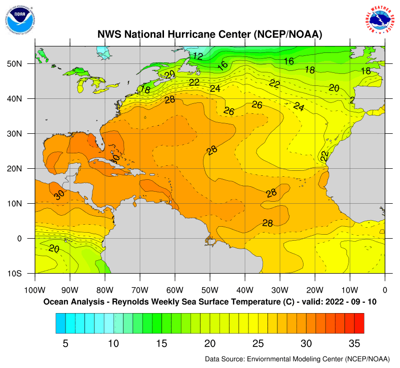
Fortunately SSTs are running below normal in this area. They are not 80-83F. Here are the maps:

While we are looking - check out off the coast of Africa - it is warming dramatically over the past couple of weeks - now running above normal :eek:


Image


Image
Last edited by gatorcane on Wed Apr 12, 2006 1:45 pm, edited 1 time in total.
0 likes   

User avatar
skysummit
S2K Supporter
S2K Supporter
Posts: 5305
Age: 49
Joined: Tue Aug 31, 2004 11:09 pm
Location: Ponchatoula, LA
Contact:

#195 Postby skysummit » Wed Apr 12, 2006 1:45 pm

Evil Jeremy wrote:how do you become a pro met?


Years of college?
0 likes   

User avatar
Evil Jeremy
S2K Supporter
S2K Supporter
Posts: 5463
Age: 32
Joined: Mon Apr 10, 2006 2:10 pm
Location: Los Angeles, CA

#196 Postby Evil Jeremy » Wed Apr 12, 2006 1:46 pm

sorry about the temps. i was looking at the map on weatherunderground.
0 likes   
Frances 04 / Jeanne 04 / Katrina 05 / Wilma 05 / Fay 08 / Debby 12 / Andrea 13 / Colin 16 / Hermine 16 / Matthew 16 / Irma 17

CHRISTY

#197 Postby CHRISTY » Wed Apr 12, 2006 1:51 pm

skysummit wrote:
Evil Jeremy wrote:if its going to develop it should happen very soon.


Do you seriously believe it to be that simple?
uh...no of course it is not that simple alot of factors have to come into play in order for a tropical cyclone to form.
0 likes   

User avatar
Evil Jeremy
S2K Supporter
S2K Supporter
Posts: 5463
Age: 32
Joined: Mon Apr 10, 2006 2:10 pm
Location: Los Angeles, CA

#198 Postby Evil Jeremy » Wed Apr 12, 2006 1:54 pm

When i said that i ment that the shear would tear it apart or that it would fall apart itself if it didnt develop quickly. that is why i said "if"
0 likes   
Frances 04 / Jeanne 04 / Katrina 05 / Wilma 05 / Fay 08 / Debby 12 / Andrea 13 / Colin 16 / Hermine 16 / Matthew 16 / Irma 17

User avatar
skysummit
S2K Supporter
S2K Supporter
Posts: 5305
Age: 49
Joined: Tue Aug 31, 2004 11:09 pm
Location: Ponchatoula, LA
Contact:

#199 Postby skysummit » Wed Apr 12, 2006 1:56 pm

Ok...so which area are you all concerned with? A or B ?

Image
0 likes   

CHRISTY

#200 Postby CHRISTY » Wed Apr 12, 2006 1:57 pm

GUYS CHECK THIS OUT U CAN MAKE OUT A ROTATION NEAR THE BAHAMAS!

Image
0 likes   


Return to “Talkin' Tropics”

Who is online

Users browsing this forum: No registered users and 69 guests