SST'S and Anomalies in Atlantic and Pacific
Moderator: S2k Moderators
Forum rules
The posts in this forum are NOT official forecasts and should not be used as such. They are just the opinion of the poster and may or may not be backed by sound meteorological data. They are NOT endorsed by any professional institution or STORM2K. For official information, please refer to products from the National Hurricane Center and National Weather Service.
-
CHRISTY
Iam not sure if you guys have seen this Interesting statement in TW Discussion.....It's quite an interesting thing to behold this early in the year. Doesn't mean that this kind of pattern will hold through the hurricane season, but we observed exactly this sort of anomaly LAST spring, so it's a bit ominous. 
* Gulf: ...NO BIG CHANGES ARE LIKELY FOR
THE NEXT SEVERAL DAYS BUT A WEAK COLD FRONT COULD NUDGE INTO THE NW GULF ON WED. HIGH PRESSURE AT THE SURFACE SHOULD DROP MORE
TO THE SOUTH... CAUSING WLY WINDS OVER A GOOD PORTION OF FLORIDA AND LIKELY HEATING UP THE E COAST OF THE STATE TO THE DREADED
90F MARK.
* Atlantic: ...ANOMALOUSLY-STRONG UPPER HIGH CONTROLS THE TROPICAL ATLC NEWARD THRU THE E-CENTRAL SUBTROPICAL ATLC WITH BROAD RIDE FROM 4N51W TO 30N30W. RIDGE IS QUITE AMPLIFIED AND RESEMBLES A PATTERN MORE LIKELY SEEN IN THE DEEP TROPICS CLOSER TO HURRICANE SEASON...
0 likes
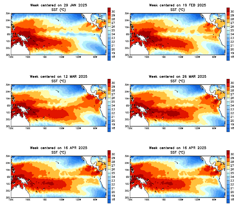
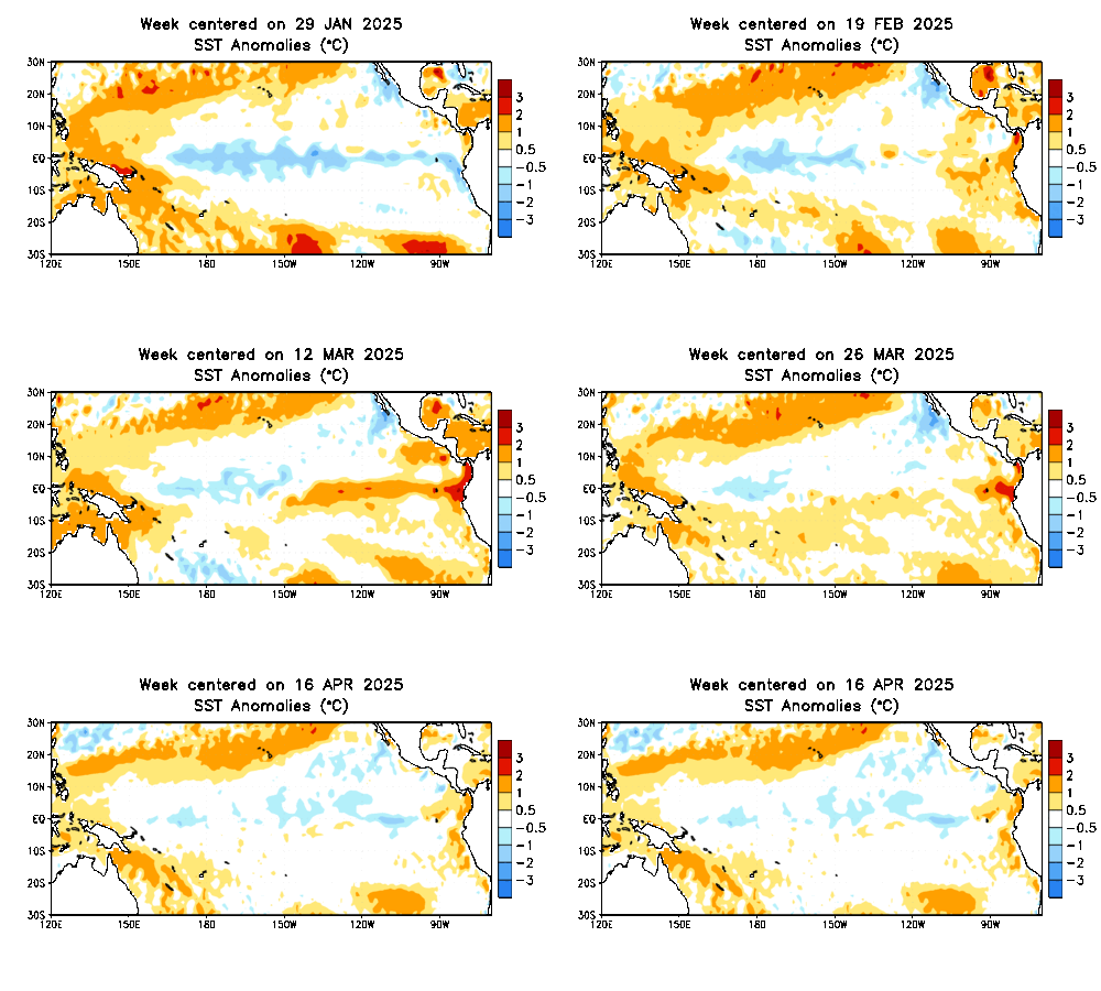
Team Ragnarok wrote:Those cooler waters off South America are slowly starting to creep westward. The weak La Nina may be trying to reinvigorate itself.
You can see that for sure e of 100w on this loop:
http://www.ssd.noaa.gov/PS/TROP/DATA/RT ... -loop.html
the trades have kicked back in over there.. give it a few days and the whole epac will cool (sst-pac-loop.htm)
0 likes
- skysummit
- S2K Supporter

- Posts: 5305
- Age: 50
- Joined: Tue Aug 31, 2004 11:09 pm
- Location: Ponchatoula, LA
- Contact:
CHRISTY wrote:Iam not sure if you guys have seen this Interesting statement in TW Discussion.....It's quite an interesting thing to behold this early in the year. Doesn't mean that this kind of pattern will hold through the hurricane season, but we observed exactly this sort of anomaly LAST spring, so it's a bit ominous.
* Gulf: ...NO BIG CHANGES ARE LIKELY FOR
THE NEXT SEVERAL DAYS BUT A WEAK COLD FRONT COULD NUDGE INTO THE NW GULF ON WED. HIGH PRESSURE AT THE SURFACE SHOULD DROP MORE
TO THE SOUTH... CAUSING WLY WINDS OVER A GOOD PORTION OF FLORIDA AND LIKELY HEATING UP THE E COAST OF THE STATE TO THE DREADED
90F MARK.
* Atlantic: ...ANOMALOUSLY-STRONG UPPER HIGH CONTROLS THE TROPICAL ATLC NEWARD THRU THE E-CENTRAL SUBTROPICAL ATLC WITH BROAD RIDE FROM 4N51W TO 30N30W. RIDGE IS QUITE AMPLIFIED AND RESEMBLES A PATTERN MORE LIKELY SEEN IN THE DEEP TROPICS CLOSER TO HURRICANE SEASON...
Yea...it's WAAAAYYY too hot this early. We hit 92 here yesterday. Dallas hit 101!
0 likes
https://128.160.23.54/products/OFA/gsscofa.gif
http://wxmaps.org/pix/atlpot.png
Temps and THC a little above norm which seems to be norm for the last several years.
http://wxmaps.org/pix/atlpot.png
Temps and THC a little above norm which seems to be norm for the last several years.
0 likes
-
Jim Cantore
looks like la nina is dead
http://www.cpc.ncep.noaa.gov/products/analysis_monitoring/enso_update/sstanim.shtml
http://www.cpc.ncep.noaa.gov/products/analysis_monitoring/enso_update/sstanim.shtml
0 likes
- SouthFloridawx
- S2K Supporter

- Posts: 8346
- Age: 47
- Joined: Tue Jul 26, 2005 1:16 am
- Location: Sarasota, FL
- Contact:
Hurricane Floyd wrote:looks like la nina is dead
http://www.cpc.ncep.noaa.gov/products/analysis_monitoring/enso_update/sstanim.shtml
Actually what I saw from that map was a resurgance of cold water coming up the coast of south america.
0 likes
-
Jim Cantore
SouthFloridawx wrote:Hurricane Floyd wrote:looks like la nina is dead
http://www.cpc.ncep.noaa.gov/products/analysis_monitoring/enso_update/sstanim.shtml
Actually what I saw from that map was a resurgance of cold water coming up the coast of south america.
good, neutral is not what we need now.
0 likes
-
MiamiensisWx
benny wrote:You can see that for sure e of 100w on this loop:
http://www.ssd.noaa.gov/PS/TROP/DATA/RT/sst-atl-loop.html
the trades have kicked back in over there.. give it a few days and the whole epac will cool (sst-pac-loop.htm)
Notice how the western Atlantic is warming rapidly due to lack of ridging and easterlies, while in the eastern Atlantic - due to better establishment of ridging over there taking place somewhat - the warming is a bit more controlled. Anyone notice that?
The western Atlantic/Caribbean will be cooking by summer!
0 likes
-
CHRISTY
CapeVerdeWave wrote:benny wrote:You can see that for sure e of 100w on this loop:
http://www.ssd.noaa.gov/PS/TROP/DATA/RT/sst-atl-loop.html
the trades have kicked back in over there.. give it a few days and the whole epac will cool (sst-pac-loop.htm)
Notice how the western Atlantic is warming rapidly due to lack of ridging and easterlies, while in the eastern Atlantic - due to better establishment of ridging over there taking place somewhat - the warming is a bit more controlled. Anyone notice that?
The western Atlantic/Caribbean will be cooking by summer!
maybe we will have more homebrew systems?
0 likes
I think its fair to say that for now La Nina is all but compeltely gone and we are back in nuetral condtions.
Also, i can also see the cold anomalies presently over western atlantic to the east of Florida,Georgia and the Carolina's being replaced by warm anomalies by July, and its those cold anomalies that has held down the overall temp anomaly of the atlantic over the past few mnths to the +0.3 range.
Also, i can also see the cold anomalies presently over western atlantic to the east of Florida,Georgia and the Carolina's being replaced by warm anomalies by July, and its those cold anomalies that has held down the overall temp anomaly of the atlantic over the past few mnths to the +0.3 range.
0 likes
Personal Forecast Disclaimer:
The posts in this forum are NOT official forecast and should not be used as such. They are just the opinion of the poster and may or may not be backed by sound meteorological data. They are NOT endorsed by any professional institution or storm2k.org. For official information, please refer to the NHC and NWS products
The posts in this forum are NOT official forecast and should not be used as such. They are just the opinion of the poster and may or may not be backed by sound meteorological data. They are NOT endorsed by any professional institution or storm2k.org. For official information, please refer to the NHC and NWS products
-
Jim Cantore
-
MiamiensisWx
Hurricane Floyd wrote:look at how cool that water is near the coast, could la nina be strengthening?
I agree; I think so.
KWT wrote:I think its fair to say that for now La Nina is all but compeltely gone and we are back in nuetral condtions.
Also, i can also see the cold anomalies presently over western atlantic to the east of Florida,Georgia and the Carolina's being replaced by warm anomalies by July, and its those cold anomalies that has held down the overall temp anomaly of the atlantic over the past few mnths to the +0.3 range.
The current ridging and U.S./elsewhere weather patterns are now leaning a bit towards La Nina in some respects, rather than towards neutral. Water temperatures/ridging in Atlantic patterns/tradewinds patterns support this. I think La Nina will make a resurge back over the next several weeks. We do, however, have a good chance of turning back towards neutral by August after this pattern change/La Nina comeback that may last a few months. Just my opinion.
0 likes
- SouthFloridawx
- S2K Supporter

- Posts: 8346
- Age: 47
- Joined: Tue Jul 26, 2005 1:16 am
- Location: Sarasota, FL
- Contact:
- SouthFloridawx
- S2K Supporter

- Posts: 8346
- Age: 47
- Joined: Tue Jul 26, 2005 1:16 am
- Location: Sarasota, FL
- Contact:
-
meteorologyman
- Category 2

- Posts: 541
- Joined: Wed Mar 15, 2006 6:48 pm
- Location: Florida, Kissimmee/St.CLoud
- cycloneye
- Admin

- Posts: 149511
- Age: 69
- Joined: Thu Oct 10, 2002 10:54 am
- Location: San Juan, Puerto Rico
meteorologyman wrote:Done thankyou Cycloneye I was looking for that post, i guess i am as blind as a bat
That is what the moderators do to help the members.
0 likes
Visit the Caribbean-Central America Weather Thread where you can find at first post web cams,radars
and observations from Caribbean basin members Click Here
and observations from Caribbean basin members Click Here
KWT wrote:I think its fair to say that for now La Nina is all but compeltely gone and we are back in nuetral condtions.
Also, i can also see the cold anomalies presently over western atlantic to the east of Florida,Georgia and the Carolina's being replaced by warm anomalies by July, and its those cold anomalies that has held down the overall temp anomaly of the atlantic over the past few mnths to the +0.3 range.
I don't think it is fair at all to say that about the pacific. Right now.. the temperature anomalies are not La Nina. But it is a time-averaged phenomenon for sure and this is the time of the year where week to week changes just aren't very stable (ie the predictability barrier). That's why CPC uses a 3 month range. La Nina is also an ocean response to what the atmosphere is doing. The trades have been weak for the past month or so.. but if they kick in again, they will be back to cool conditions. Do we immediately say "La Nina is back"?? The atmosphere sure looks a lot more like La Nina than neutral.. the wind anomalies in the Atlantic are scary: http://www.cpc.ncep.noaa.gov/products/h ... 00_30d.gif
Give it a few weeks before we claim La Nina is dead for good. Might not matter much in the long run.. considering 2005 was a neutral year, 2004 was a mild El Nino and the last true La Nina was 1999.. and both those years were more active than 99
0 likes
Who is online
Users browsing this forum: No registered users and 402 guests


