97w invest at WPAC

This is the general tropical discussion area. Anyone can take their shot at predicting a storms path.

Moderator: S2k Moderators

Forum rules

The posts in this forum are NOT official forecasts and should not be used as such. They are just the opinion of the poster and may or may not be backed by sound meteorological data. They are NOT endorsed by any professional institution or STORM2K. For official information, please refer to products from the National Hurricane Center and National Weather Service.

Help Support Storm2K
Message
Author
User avatar
cycloneye
Admin
Admin
Posts: 146216
Age: 69
Joined: Thu Oct 10, 2002 10:54 am
Location: San Juan, Puerto Rico

97w invest at WPAC

#1 Postby cycloneye » Wed Apr 26, 2006 2:33 pm

Finnally after more than a month a new invest is issued by NRL for the WPAC.

97w Invest

Now let's see if this disturbance develops or not as time goes by.
0 likes   

HurricaneHunter914
Category 5
Category 5
Posts: 4439
Age: 31
Joined: Fri Mar 10, 2006 7:36 pm
Location: College Station, TX

#2 Postby HurricaneHunter914 » Wed Apr 26, 2006 2:36 pm

Doesn't the WPAC usually form very strong storms?
0 likes   

User avatar
HURAKAN
Professional-Met
Professional-Met
Posts: 46086
Age: 38
Joined: Thu May 20, 2004 4:34 pm
Location: Key West, FL
Contact:

#3 Postby HURAKAN » Wed Apr 26, 2006 2:37 pm

It has been a really quiet time in the WPAC.
0 likes   

User avatar
mike815
Category 5
Category 5
Posts: 1460
Joined: Fri Jul 22, 2005 8:21 am
Location: palm bay fl

#4 Postby mike815 » Wed Apr 26, 2006 2:56 pm

it sure has been
0 likes   

User avatar
James
Category 5
Category 5
Posts: 1531
Joined: Tue Aug 24, 2004 10:29 am
Location: Gloucestershire, England
Contact:

#5 Postby James » Wed Apr 26, 2006 4:01 pm

This time last year there were three systems already. Statistically there should have been 1.7 named systems by this time. Perhaps this system will even out the numbers a little.
0 likes   

User avatar
Hurricanehink
S2K Supporter
S2K Supporter
Posts: 2041
Joined: Sun Nov 16, 2003 2:05 pm
Location: New Jersey

#6 Postby Hurricanehink » Wed Apr 26, 2006 4:15 pm

Yea, especially since last year the WPAC lost to the Atlantic!
0 likes   

User avatar
cycloneye
Admin
Admin
Posts: 146216
Age: 69
Joined: Thu Oct 10, 2002 10:54 am
Location: San Juan, Puerto Rico

#7 Postby cycloneye » Wed Apr 26, 2006 6:27 pm

97w Visible Pic

:uarrow: :uarrow: :uarrow:

Looks somewhat better than earlier today.
0 likes   

HurricaneHunter914
Category 5
Category 5
Posts: 4439
Age: 31
Joined: Fri Mar 10, 2006 7:36 pm
Location: College Station, TX

#8 Postby HurricaneHunter914 » Wed Apr 26, 2006 8:24 pm

Looks like the cloud cover has increased significantly.
0 likes   

User avatar
James
Category 5
Category 5
Posts: 1531
Joined: Tue Aug 24, 2004 10:29 am
Location: Gloucestershire, England
Contact:

#9 Postby James » Thu Apr 27, 2006 4:40 am

It's looking kinda like it's fizzled at the moment, but with the diurnal maximum perhaps it might flare up somewhat during the night.
0 likes   

Weatherfreak000

#10 Postby Weatherfreak000 » Thu Apr 27, 2006 7:41 am

Wow, it has been a really slow WPAC season it appears some of that energy may be getting spread in just about every basin but the EPAC honestly.

Looks decent though. Bears watching? lol.
0 likes   

HurricaneHunter914
Category 5
Category 5
Posts: 4439
Age: 31
Joined: Fri Mar 10, 2006 7:36 pm
Location: College Station, TX

#11 Postby HurricaneHunter914 » Thu Apr 27, 2006 4:12 pm

http://cimss.ssec.wisc.edu/tropic/real- ... rgms5n.GIF

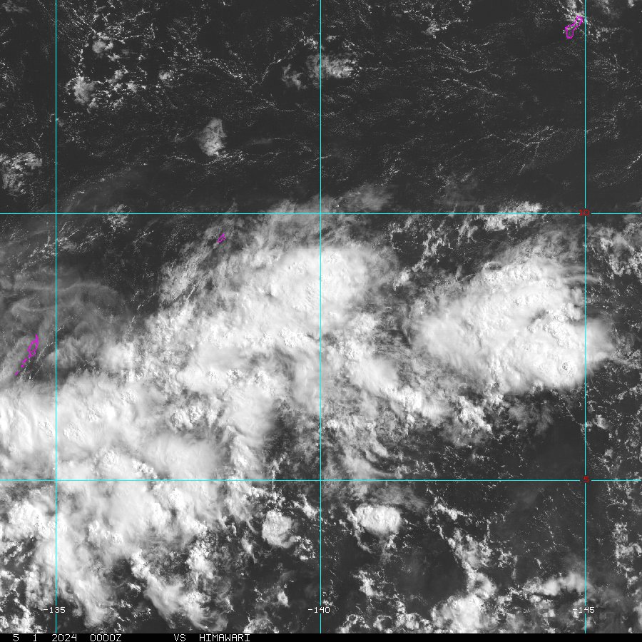
A little less organized today, but if it merges with that blob under it, it still has a chance.
0 likes   

User avatar
HURAKAN
Professional-Met
Professional-Met
Posts: 46086
Age: 38
Joined: Thu May 20, 2004 4:34 pm
Location: Key West, FL
Contact:

#12 Postby HURAKAN » Thu Apr 27, 2006 10:25 pm

Image

1 ... 2 ... 3 ... POOF!!!
0 likes   

HurricaneBill
Category 5
Category 5
Posts: 3420
Joined: Sun Apr 11, 2004 5:51 pm
Location: East Longmeadow, MA, USA

#13 Postby HurricaneBill » Thu Apr 27, 2006 10:59 pm

I guess the WPAC hit the snooze button.
0 likes   

HurricaneHunter914
Category 5
Category 5
Posts: 4439
Age: 31
Joined: Fri Mar 10, 2006 7:36 pm
Location: College Station, TX

#14 Postby HurricaneHunter914 » Fri Apr 28, 2006 7:35 am

Oh well. Better luck next time.
0 likes   

HurricaneBill
Category 5
Category 5
Posts: 3420
Joined: Sun Apr 11, 2004 5:51 pm
Location: East Longmeadow, MA, USA

#15 Postby HurricaneBill » Fri Apr 28, 2006 1:06 pm

Well, even if it's another quiet season, I wouldn't let my guard down.

I've seen quiet seasons produce destructive typhoons.
0 likes   

User avatar
HURAKAN
Professional-Met
Professional-Met
Posts: 46086
Age: 38
Joined: Thu May 20, 2004 4:34 pm
Location: Key West, FL
Contact:

#16 Postby HURAKAN » Fri Apr 28, 2006 1:09 pm

We know that tropical activity goes in hand with the WPAC, therefore, in a month or so things will most likely change dramatically.
0 likes   

User avatar
James
Category 5
Category 5
Posts: 1531
Joined: Tue Aug 24, 2004 10:29 am
Location: Gloucestershire, England
Contact:

#17 Postby James » Sat Apr 29, 2006 4:19 am

I wonder whether the system to the east of where 97W was may be worth keeping an eye on. It doesn't look too bad right now.
0 likes   

HurricaneHunter914
Category 5
Category 5
Posts: 4439
Age: 31
Joined: Fri Mar 10, 2006 7:36 pm
Location: College Station, TX

#18 Postby HurricaneHunter914 » Sat Apr 29, 2006 7:49 am

Looks better than it was yesterday.
0 likes   


Return to “Talkin' Tropics”

Who is online

Users browsing this forum: Argcane, LarryWx, quaqualita and 70 guests