
Texas Severe Weather Potential for 4/28 and 4/29
Moderator: S2k Moderators
Forum rules

The posts in this forum are NOT official forecast and should not be used as such. They are just the opinion of the poster and may or may not be backed by sound meteorological data. They are NOT endorsed by any professional institution or STORM2K.


-
Extremeweatherguy

- Category 5

- Posts: 11095
- Joined: Mon Oct 10, 2005 8:13 pm
- Location: Florida
-
southerngale

- Retired Staff

- Posts: 27418
- Joined: Thu Oct 10, 2002 1:27 am
- Location: Southeast Texas (Beaumont area)
Extremeweatherguy wrote:Jeff, any updates on the situation? Your morning report was great, I would love to see another one this evening to see how things are evolving in a pro met perspective.
I got his email update at 16:46:46 2006
Severe Weather outbreak underway to our west with two tornado watch boxes in effect.
Large upper level storm system starting to eject into the TX panhandle with strong lifting overspreading the W TX dryline. Supercells with very large hail and tornadoes have developed from north Mexico to NE of Lubbock.
Local air mass has modified greatly in the last 24 hours with surface dewpoints now at 70 at most reporting stations. Low level shear is increasing...per special 18 Z (noon) Del Rio sounding with 0-3 km shear of 199 m^2/s^2...no surprise we are seeing good supercell formation with rotation. Ledbetter, TX profiler is showing SSE winds of 25kts at 1km increasing to 105kts at 8-10 km while veering to the WSW....there is increasing wind speed with height along with nearly 90 degrees of turning from the surface to the upper levels.
Forecast models continue to show a favorable evolution of severe weather to our west into our area. Timing appears slightly slower than this morning which may push the main event into the 600am to noon time frame Saturday. This is typically an unfavorable time for an MCS to maintain itself as this is the time of day when instability is at a minimum....however impressive dynamics associated with this system should compensate for a lack of instability. Main threat remains damaging winds along the leading edge as well as gusty wake low winds potentially behind the main line. Complex should enter our western zones between 600am-900am and then into the metro area between 800am-1100am.
Discrete cells rooted in the boundary layer ahead of the main line may exhibit strong rotation and produce tornadoes due to the large amounts of low level wind shear, but these should be few....the main concern is wind damage along the leading edge of the MCS/bow echo.
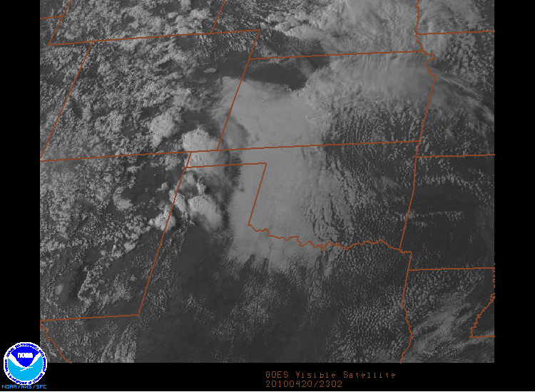
Visible Satellite Image with Tornado Watchbox outlines:
0 likes


-
Extremeweatherguy
- Category 5
- Posts: 11095
- Joined: Mon Oct 10, 2005 8:13 pm
- Location: Florida
thanks for posting that! Sounds like we are still expecting a strong MCS and then that wake low event.southerngale wrote:Extremeweatherguy wrote:Jeff, any updates on the situation? Your morning report was great, I would love to see another one this evening to see how things are evolving in a pro met perspective.
I got his email update at 16:46:46 2006Severe Weather outbreak underway to our west with two tornado watch boxes in effect.
Large upper level storm system starting to eject into the TX panhandle with strong lifting overspreading the W TX dryline. Supercells with very large hail and tornadoes have developed from north Mexico to NE of Lubbock.
Local air mass has modified greatly in the last 24 hours with surface dewpoints now at 70 at most reporting stations. Low level shear is increasing...per special 18 Z (noon) Del Rio sounding with 0-3 km shear of 199 m^2/s^2...no surprise we are seeing good supercell formation with rotation. Ledbetter, TX profiler is showing SSE winds of 25kts at 1km increasing to 105kts at 8-10 km while veering to the WSW....there is increasing wind speed with height along with nearly 90 degrees of turning from the surface to the upper levels.
Forecast models continue to show a favorable evolution of severe weather to our west into our area. Timing appears slightly slower than this morning which may push the main event into the 600am to noon time frame Saturday. This is typically an unfavorable time for an MCS to maintain itself as this is the time of day when instability is at a minimum....however impressive dynamics associated with this system should compensate for a lack of instability. Main threat remains damaging winds along the leading edge as well as gusty wake low winds potentially behind the main line. Complex should enter our western zones between 600am-900am and then into the metro area between 800am-1100am.
Discrete cells rooted in the boundary layer ahead of the main line may exhibit strong rotation and produce tornadoes due to the large amounts of low level wind shear, but these should be few....the main concern is wind damage along the leading edge of the MCS/bow echo.
Visible Satellite Image with Tornado Watchbox outlines:
0 likes
-
Extremeweatherguy
- Category 5
- Posts: 11095
- Joined: Mon Oct 10, 2005 8:13 pm
- Location: Florida
-
Extremeweatherguy
- Category 5
- Posts: 11095
- Joined: Mon Oct 10, 2005 8:13 pm
- Location: Florida
-
Yankeegirl

- Category 5
- Posts: 3417
- Age: 50
- Joined: Sun May 23, 2004 11:59 pm
- Location: Cy-Fair, Northwest Houston
- Contact:
-
Extremeweatherguy
- Category 5
- Posts: 11095
- Joined: Mon Oct 10, 2005 8:13 pm
- Location: Florida
The good news is that I think the models may be too slow. Looking at current trends, the storms will probably get here earlier than noon (which is 18 hours away). Actually...looking at the storm movement I think they may even get here as early as 3 - 6am...but if the models do happen to be right, then 10am - 1pm is probably the latest case scenario. Either way, the thing that interests me the most is the potential of a wake low scenario. wake lows have been known to produce sustained winds of 30-55mph and gusts up to 80mph on other occasions. It would be quite crazy if we had this kind of scenario play out...could you imagine a period of TS force winds BEHIND a MCS? It would be weird and many would be caught off guard.Yankeegirl wrote:Great, I have to work tomorrow 9-345.. Yuck, I wanna be home to watch the storms!!!
0 likes

0 likes
The following post is NOT an official forecast and should not be used as such. It is just the opinion of the poster and may or may not be backed by sound meteorological data. It is NOT endorsed by any professional institution including storm2k.org For Official Information please refer to the NHC and NWS products.
-
Extremeweatherguy
- Category 5
- Posts: 11095
- Joined: Mon Oct 10, 2005 8:13 pm
- Location: Florida
there is also this site:
http://people.aero.und.edu/~haertel/pub/hj00.pdf
and here is more on that S. Florida event that was posted above by KatDaddy:
http://www.srh.noaa.gov/mfl/newpage/April_13_2004.html
Also, here is a key for knots to mph when reading these reports:
35 knots = 40mph
40 knots = 46mph
45 knots = 52mph
50 knots = 58mph
55 knots = 63mph
60 knots = 69mph
65 knots = 75mph
70 knots = 81mph
**Usually 'Wake low' events do not have gusts that exceed 70 knots. The common range for one of these events is between 40 and 45 knots for most places and a few places may see wind gusts to 45-60 knots. In strong events, wind gusts to 65-70 knots are possible. The one thing that makes these events dangerous, though, is that these strong wind gusts can last for 30-90+ minutes (And in some cases for many, many hours) they are also accompanied by sustained winds as high as weak to moderate tropical storm strength. Damage left behind is similar to that seen in a tropical storm, and minor structural damage can even occur in extreme cases. These events can also lead to heat bursts, where the air temperature may quickly rise more than 5-10 degrees in a matter of minutes.**
0 likes
Per meso disco. 685 and expansion and extension of watchboxes...everything remains in place for severe weather tonight into Sat. AM.
Large scale linear MCS should develop across W TX shortly (3-4 hours) behind current supercell activity over C and NC TX. Shear profiles remain impressive although instability across SE TX is somewhat meager...much higher where surface heating took place across C TX.
Severe MCS should approach western counties after 400am and into the metro area between 700am and 900am. Main threat will be damaging straight line winds with potential bows and LEWPS. Models still show good low level inflow on the backside of the MCS suggesting meso low formation...however the intensity of the feature and resulting PGF and winds are left to debate.
Main threat remains wind damage along the leading edge of a severe MCS/bow echo event. Unfavorable time of day may preclude a widespread event, but good dynamics and forward motion may compensate for lack of instability....we shall see. Cells ahead of the main line, if they develop, could produce tornadoes given the very favorable low level shear in place.
0 likes
-
Extremeweatherguy
- Category 5
- Posts: 11095
- Joined: Mon Oct 10, 2005 8:13 pm
- Location: Florida
thanks for the update jeff...it will be interesting to see how this all plays out and also to see how strong the potential wake low becomes.jeff wrote:Per meso disco. 685 and expansion and extension of watchboxes...everything remains in place for severe weather tonight into Sat. AM.
Large scale linear MCS should develop across W TX shortly (3-4 hours) behind current supercell activity over C and NC TX. Shear profiles remain impressive although instability across SE TX is somewhat meager...much higher where surface heating took place across C TX.
Severe MCS should approach western counties after 400am and into the metro area between 700am and 900am. Main threat will be damaging straight line winds with potential bows and LEWPS. Models still show good low level inflow on the backside of the MCS suggesting meso low formation...however the intensity of the feature and resulting PGF and winds are left to debate.
Main threat remains wind damage along the leading edge of a severe MCS/bow echo event. Unfavorable time of day may preclude a widespread event, but good dynamics and forward motion may compensate for lack of instability....we shall see. Cells ahead of the main line, if they develop, could produce tornadoes given the very favorable low level shear in place.
0 likes
-
Extremeweatherguy
- Category 5
- Posts: 11095
- Joined: Mon Oct 10, 2005 8:13 pm
- Location: Florida
here is the latest from the SPC:
AS STRONG FORCING CONTINUES TO ADVANCE EWD INTO THE PLAINS...EXPECT
SURFACE BASED SUPERCELLS TO EVOLVE INTO MIXED LINEAR/DISCRETE MODES
WITH CONVECTION CONTINUING THROUGH THE NIGHT. OVERNIGHT PRIND THAT
FAIRLY EXTENSIVE SQUALL LINE MAY EVOLVE FROM CNTRL/SRN OK TO
CNTRL/ERN TX. THE THREAT OF VERY LARGE HAIL AND DAMAGING WINDS WILL
PERSIST...WITH THE GREATEST TORNADO THREAT ALONG AND SOUTH OF THE
RED RIVER WHERE MAXIMUM INSTABILITY AND LOW LEVEL MOISTURE RESIDE.
0 likes
Return to “USA & Caribbean Weather”
Who is online
Users browsing this forum: Brent and 84 guests