
SST'S and Anomalies in Atlantic and Pacific #2
Moderator: S2k Moderators
Forum rules

The posts in this forum are NOT official forecasts and should not be used as such. They are just the opinion of the poster and may or may not be backed by sound meteorological data. They are NOT endorsed by any professional institution or STORM2K. For official information, please refer to products from the National Hurricane Center and National Weather Service.


-
HurricaneHunter914
- Category 5

- Posts: 4439
- Age: 32
- Joined: Fri Mar 10, 2006 7:36 pm
- Location: College Station, TX
-
cycloneye

- Admin

- Posts: 149505
- Age: 69
- Joined: Thu Oct 10, 2002 10:54 am
- Location: San Juan, Puerto Rico
Latest update of Atlantic anomalies

Much warmer Atlantic at this new update except for small cool pockets in the Western Atlantic.
Much warmer Atlantic at this new update except for small cool pockets in the Western Atlantic.
0 likes

-
meteorologyman
- Category 2

- Posts: 541
- Joined: Wed Mar 15, 2006 6:48 pm
- Location: Florida, Kissimmee/St.CLoud


A few more reasons to sweat the coming hurricane season 
http://wxmaps.org/pix/atlpot.png
https://128.160.23.54/products/OFA/gsscofa.gif
http://wxmaps.org/pix/atlpot.png
https://128.160.23.54/products/OFA/gsscofa.gif
0 likes
-
Weatherfreak000
-
meteorologyman
- Category 2
- Posts: 541
- Joined: Wed Mar 15, 2006 6:48 pm
- Location: Florida, Kissimmee/St.CLoud
-
meteorologyman
- Category 2
- Posts: 541
- Joined: Wed Mar 15, 2006 6:48 pm
- Location: Florida, Kissimmee/St.CLoud
These are sattelite imageries of Africa, U.S, Atlantic, wind shear and SST
Note this is a BIG PAGE/
http://www.crownweather.com/tropical.html
Note this is a BIG PAGE/
http://www.crownweather.com/tropical.html
0 likes
-
txwatcher91
- Category 5
- Posts: 1498
- Joined: Tue Aug 02, 2005 2:29 pm
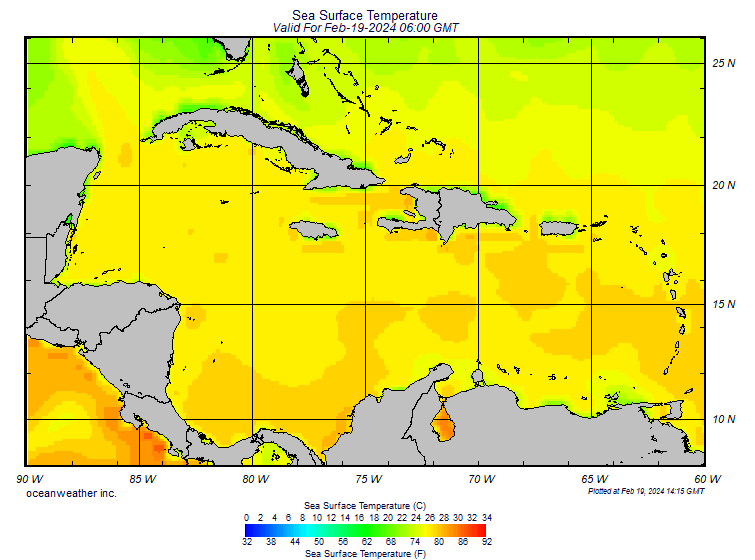
Look at the temps in the Carribean! Some areas are already near 32C or 90F.
May 2nd GOM temps
May 2nd GOM temps
0 likes


-
GeneratorPower

- S2K Supporter

- Posts: 1648
- Age: 46
- Joined: Sun Dec 18, 2005 11:48 pm
- Location: Huntsville, AL
-
Matt-hurricanewatcher
The central and eastern Atlatnic is cooler this year...With a slightly cooler Caribbean. On the other hand the Gulf of Mexico is on fire...
Last year Azores high was so strong that it sheared systems+sucked SAL into the Atlantic. Which killed the Eastern Atlatnic season. This year could have a weaker Azores high but a strong Bermuda high. Which will likely have a 2004 like pattern with storms forming strongly out over the eastern then recurving. But if they get under the Bermuda watch out florida.
The Gulf is going to be a blood bath.
0 likes
-
Weatherfreak000
Matt-hurricanewatcher wrote:The central and eastern Atlatnic is cooler this year...With a slightly cooler Caribbean. On the other hand the Gulf of Mexico is on fire...
Last year Azores high was so strong that it sheared systems+sucked SAL into the Atlantic. Which killed the Eastern Atlatnic season. This year could have a weaker Azores high but a strong Bermuda high. Which will likely have a 2004 like pattern with storms forming strongly out over the eastern then recurving. But if they get under the Bermuda watch out florida.
The Gulf is going to be a blood bath.
Yeah, I had a good feeling we were gonna see a signficiant BOC Season this year and it's looking pretty ugly down there.
Although the water is still not really as warm as last year I expect an exceptional change coming, that will likely make both years very comparable.
Guess we'll have to find out, however
0 likes
Who is online
Users browsing this forum: Kingarabian, ljmac75, Ntxw, Ulf, USTropics and 262 guests