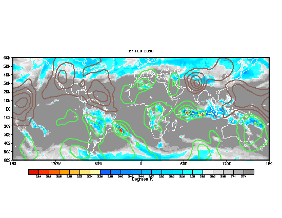
Ok folks this thread and I am sure many ten pages threads about this theme will be dedicated to discuss all about this important MJO factor that plays a roll during hurricane seasons.We will see as the weeks and months go by during this 2006 hurricane season how the MJO (Madden Julian Occillation) influences the number of named systems that will form.
MJO
Moderator: S2k Moderators
Forum rules
The posts in this forum are NOT official forecasts and should not be used as such. They are just the opinion of the poster and may or may not be backed by sound meteorological data. They are NOT endorsed by any professional institution or STORM2K. For official information, please refer to products from the National Hurricane Center and National Weather Service.
- cycloneye
- Admin

- Posts: 148755
- Age: 69
- Joined: Thu Oct 10, 2002 10:54 am
- Location: San Juan, Puerto Rico
MJO
MJO Graphic


Ok folks this thread and I am sure many ten pages threads about this theme will be dedicated to discuss all about this important MJO factor that plays a roll during hurricane seasons.We will see as the weeks and months go by during this 2006 hurricane season how the MJO (Madden Julian Occillation) influences the number of named systems that will form.
Ok folks this thread and I am sure many ten pages threads about this theme will be dedicated to discuss all about this important MJO factor that plays a roll during hurricane seasons.We will see as the weeks and months go by during this 2006 hurricane season how the MJO (Madden Julian Occillation) influences the number of named systems that will form.
Last edited by cycloneye on Sat Aug 26, 2006 8:44 am, edited 4 times in total.
0 likes
- cycloneye
- Admin

- Posts: 148755
- Age: 69
- Joined: Thu Oct 10, 2002 10:54 am
- Location: San Juan, Puerto Rico
Aquawind wrote:That graphic looks like it's wrong..lol I mean how relevent can it be if it happens to show up directly over the Chanchu and yet it's completely dry phase around it.. Looks like Chanchu has made it's own MOJO..
Yeah,that's kind of interesting.
0 likes
Visit the Caribbean-Central America Weather Thread where you can find at first post web cams,radars
and observations from Caribbean basin members Click Here
and observations from Caribbean basin members Click Here
- milankovitch
- Tropical Storm

- Posts: 243
- Age: 40
- Joined: Fri Sep 17, 2004 11:30 pm
- Location: Menands, NY; SUNY Albany
- Contact:
http://www.cpc.ncep.noaa.gov/products/p ... ummary.pdf
MJO Summary
http://www.cpc.ncep.noaa.gov/products/p ... update.pdf
Weekly MJO disco
As for the image above the green lines indicate upper level divergence at 200mb and the IR. You would expect upper level divergence with a large tropical cyclone like Chanchu that would eclipse any MJO signature. The MJO is not the be all end all you can still get tropical cyclones in the dry phase of the MJO. With suppresed convection they should on average be weakened by the dry phase.
0 likes
- wxmann_91
- Category 5

- Posts: 8013
- Age: 34
- Joined: Fri Jul 15, 2005 2:49 pm
- Location: Southern California
- Contact:
MJO is more important early in the season when convection determines where and how many storms form. During the peak and later, it is less important, and the wet phase can sometimes be unfavorable as I noticed last year. Perhaps, as milankovich alluded to, the maps also show increased divergence, which favors convection, but also show signs of shear. (In this case, it is shear caused by Chanchu, not affecting it.)
0 likes
Patrick99 wrote:If I remember correctly, during the past few seasons, we've seen several hurricanes traversing the Atlantic right in the middle of a MJO dry phase.
Yes we sure have. The MJO has the greatest relevance in the WestPac, then the EastPac, then the Atlantic. A lot of the time unless it is a strong MJO there is little difference in the Atlantic in terms of genesis. One thing to take note of is that basically the entire western hemisphere is in an active phase of divergence while the eastern hemisphere is very slow especially in the westpac. the active phase should enter the indian ocean (or is doing now) very soon.
0 likes
-
JonathanBelles
- Professional-Met

- Posts: 11430
- Age: 35
- Joined: Sat Dec 24, 2005 9:00 pm
- Location: School: Florida State University (Tallahassee, FL) Home: St. Petersburg, Florida
- Contact:
- Hybridstorm_November2001
- S2K Supporter

- Posts: 2817
- Joined: Sat Aug 21, 2004 2:50 pm
- Location: SW New Brunswick, Canada
- Contact:
-
JonathanBelles
- Professional-Met

- Posts: 11430
- Age: 35
- Joined: Sat Dec 24, 2005 9:00 pm
- Location: School: Florida State University (Tallahassee, FL) Home: St. Petersburg, Florida
- Contact:
- cycloneye
- Admin

- Posts: 148755
- Age: 69
- Joined: Thu Oct 10, 2002 10:54 am
- Location: San Juan, Puerto Rico
fact789 wrote:whats an MJO?
MJO Explanation
Above is more explanation about what is the Madden Julian Occillation.
0 likes
- terstorm1012
- S2K Supporter

- Posts: 1314
- Age: 44
- Joined: Fri Sep 10, 2004 5:36 pm
- Location: Millersburg, PA
- wxwatcher91
- Category 5

- Posts: 1606
- Joined: Wed Jul 06, 2005 2:43 pm
- Location: Keene, NH
- Contact:
Who is online
Users browsing this forum: No registered users and 33 guests


