'Cone of Concern' changed/replaced for 2006

This is the general tropical discussion area. Anyone can take their shot at predicting a storms path.

Moderator: S2k Moderators

Forum rules

The posts in this forum are NOT official forecasts and should not be used as such. They are just the opinion of the poster and may or may not be backed by sound meteorological data. They are NOT endorsed by any professional institution or STORM2K. For official information, please refer to products from the National Hurricane Center and National Weather Service.

Help Support Storm2K
Message
Author
spinfan4eva
Category 1
Category 1
Posts: 295
Joined: Tue Aug 23, 2005 1:27 am
Location: Jacksonville, Florida
Contact:

'Cone of Concern' changed/replaced for 2006

#1 Postby spinfan4eva » Thu Jun 01, 2006 8:23 pm

This is news to me but may have been posted here b4. Noticed in this years local hurricane preparedness guide.... Looks like they are doing away with track cone and going with wind effects probabillities this year. Like the probabillity of a location getting storm force or hurricane force winds. I like the idea of a wind probabillity "bullseye" but the track is important as well for things like surge flooding-why cant they just have both, I guess that could confuse some though :roll:

Here is a copy of the full explanation and example from the local guide

Image

Link to full size image: http://i48.photobucket.com/albums/f206/ ... titled.jpg

--edit-- I dunno, maybe its the same thing, the eye is going to have the highest probabillity of stronges winds of course.
Last edited by spinfan4eva on Thu Jun 01, 2006 8:28 pm, edited 1 time in total.
0 likes   

JonathanBelles
Professional-Met
Professional-Met
Posts: 11430
Age: 35
Joined: Sat Dec 24, 2005 9:00 pm
Location: School: Florida State University (Tallahassee, FL) Home: St. Petersburg, Florida
Contact:

#2 Postby JonathanBelles » Thu Jun 01, 2006 8:25 pm

they're not using the cone anymore???!!!
0 likes   

Rainband

Re: 'Cone of Concern' changed/replaced for 2006

#3 Postby Rainband » Thu Jun 01, 2006 8:29 pm

spinfan4eva wrote:This is news to me but may have been posted here b4. Noticed in this years local hurricane preparedness guide.... Looks like they are doing away with track cone and going with wind effects probabillities this year. Like the probabillity of a location getting storm force or hurricane force winds. I like the idea of a wind probabillity "bullseye" but the track is important as well for things like surge flooding-why cant they just have both, I guess that could confuse some though :roll:

Here is a copy of the full explanation and example from the local guide

Image

Link to full size image: http://i48.photobucket.com/albums/f206/ ... titled.jpg

--edit-- I dunno, maybe its the same thing, the eye is going to have the highest probabillity of stronges winds of course.
That is from a news station not The NHC.
0 likes   

bigmike

#4 Postby bigmike » Thu Jun 01, 2006 8:37 pm

It will still be known as "the cone of death" however. :lol:
0 likes   

spinfan4eva
Category 1
Category 1
Posts: 295
Joined: Tue Aug 23, 2005 1:27 am
Location: Jacksonville, Florida
Contact:

Re: 'Cone of Concern' changed/replaced for 2006

#5 Postby spinfan4eva » Thu Jun 01, 2006 8:38 pm

Rainband wrote:That is from a news station not The NHC.


True but the news station show the same maps as the NHC just with their logo and different colors. There has always been one color in the cone with a line down the middle for the track. Apparently they are now going to be bullseyes going back to the storms current position so you have to make your own line.
0 likes   

Rainband

Re: 'Cone of Concern' changed/replaced for 2006

#6 Postby Rainband » Thu Jun 01, 2006 8:48 pm

spinfan4eva wrote:
Rainband wrote:That is from a news station not The NHC.


True but the news station show the same maps as the NHC just with their logo and different colors. There has always been one color in the cone with a line down the middle for the track. Apparently they are now going to be bullseyes going back to the storms current position so you have to make your own line.
That is a product from the station NOT the NHC
0 likes   

clfenwi
Category 5
Category 5
Posts: 3331
Joined: Thu Jun 09, 2005 12:54 pm

#7 Postby clfenwi » Thu Jun 01, 2006 8:54 pm

I'm reasonably certain there was a topic on this when the Public Information Statement on this came out back in February.

The NHC replaced the Strike Probability Graphic with the
Wind Speed Probability Graphic
0 likes   

Rainband

#8 Postby Rainband » Thu Jun 01, 2006 8:56 pm

clfenwi wrote:I'm reasonably certain there was a topic on this when the Public Information Statement on this came out back in February.

The NHC replaced the Strike Probability Graphic with the
Wind Speed Probability Graphic
ah. I see At any rate it doesn't really change anything.
0 likes   

Rainband

#9 Postby Rainband » Thu Jun 01, 2006 8:59 pm

It will be more accurate if anything.
0 likes   

User avatar
SouthFloridawx
S2K Supporter
S2K Supporter
Posts: 8346
Age: 46
Joined: Tue Jul 26, 2005 1:16 am
Location: Sarasota, FL
Contact:

#10 Postby SouthFloridawx » Thu Jun 01, 2006 9:01 pm

Rainband wrote:It will be more accurate if anything.


Very true... I think this is a much better graphic.
0 likes   

Brent
S2K Supporter
S2K Supporter
Posts: 38117
Age: 37
Joined: Sun May 16, 2004 10:30 pm
Location: Tulsa Oklahoma
Contact:

#11 Postby Brent » Thu Jun 01, 2006 9:16 pm

SouthFloridawx wrote:
Rainband wrote:It will be more accurate if anything.


Very true... I think this is a much better graphic.


Yeah... a lot of people(myself included) got too focused on that silly black line in the past.
0 likes   
#neversummer

CHRISTY

#12 Postby CHRISTY » Thu Jun 01, 2006 9:28 pm

alot of people were wondering what happend in southflorida when katrina took that jog to the south...People need to realize that we were under that hurricane warning and just because the eye is not forcast to come over youre area u always need to prepare like its heading right over you.because hurricanes are very unpredictable and at the last minute they can jog to left or to the right and u will be under the gun.
0 likes   

User avatar
wxman57
Moderator-Pro Met
Moderator-Pro Met
Posts: 23021
Age: 68
Joined: Sat Jun 21, 2003 8:06 pm
Location: Houston, TX (southwest)

#13 Postby wxman57 » Thu Jun 01, 2006 9:31 pm

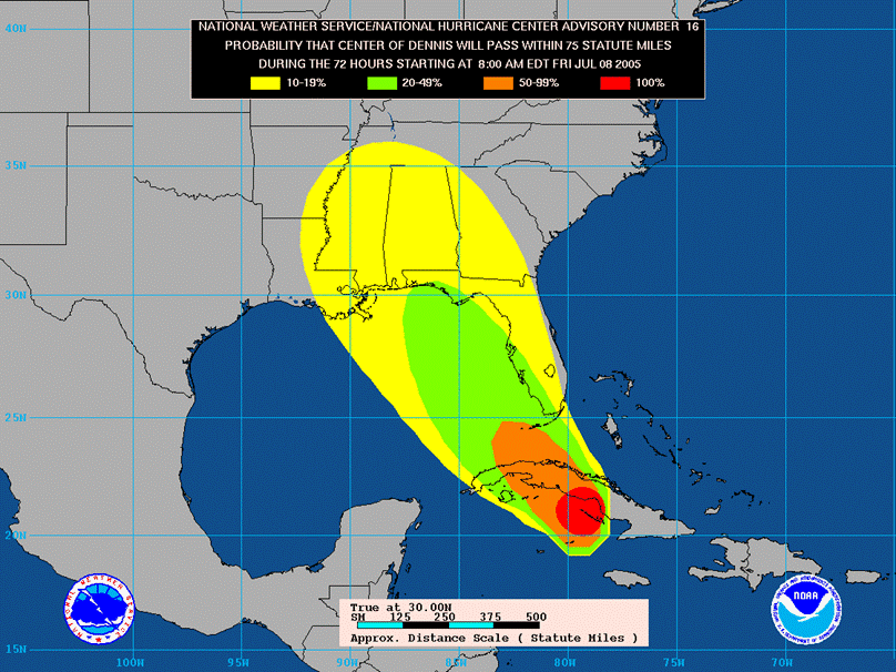
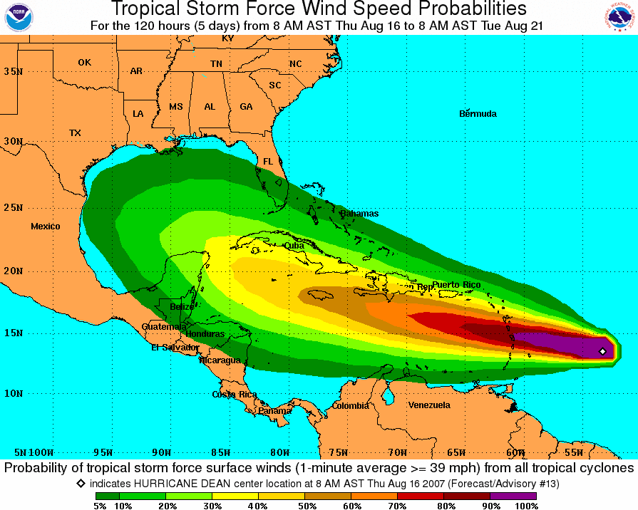
The cone isn't going away, the NHC is just adding new graphics that indicate the probability of 39, 58, and 74 mph wind fields impacting a location - the wind probability maps. Unlike the current probabilities that are based mostly upon climatology and NOT the current forecast track or any confidence in that track, these new probability maps WILL consider the current forecast track and the projected wind radii.

While there will be no accountinig for forecast confidence in NHC's cone, they are going to a 5-year average error cone in 2006. The reason for this is that there have been many advances in track forecasting in recent years and a 10-year cone is just too large now. It doesn't represent modern error as well as a 5-year cone.
0 likes   

User avatar
boca
Category 5
Category 5
Posts: 6372
Age: 60
Joined: Mon Dec 15, 2003 8:49 am
Location: Boca Raton,FL

#14 Postby boca » Thu Jun 01, 2006 9:40 pm

Isn't there accuracy down to 300 miles at 72 hours. Please correct me if I'm wrong.
0 likes   

User avatar
wxman57
Moderator-Pro Met
Moderator-Pro Met
Posts: 23021
Age: 68
Joined: Sat Jun 21, 2003 8:06 pm
Location: Houston, TX (southwest)

#15 Postby wxman57 » Thu Jun 01, 2006 9:46 pm

boca wrote:Isn't there accuracy down to 300 miles at 72 hours. Please correct me if I'm wrong.


It's actually just under 300 miles at 120 hours now, I believe. Now that is for the 60% probility area. It means that 60% of the time, the track will be accurate to within 300 miles at 120 hours. Of course, 40% of the time the track may go outside that cone. Here's a link to the accuracy graphic:

http://www.nhc.noaa.gov/verification/fi ... _noTDs.gif

Here's the main errors page:
http://www.nhc.noaa.gov/verification/verify5.shtml?
0 likes   

User avatar
boca
Category 5
Category 5
Posts: 6372
Age: 60
Joined: Mon Dec 15, 2003 8:49 am
Location: Boca Raton,FL

#16 Postby boca » Thu Jun 01, 2006 9:48 pm

Thanks very helpful.
0 likes   

mtm4319
Category 5
Category 5
Posts: 1537
Joined: Sun Sep 12, 2004 2:47 am
Location: Mobile, AL

#17 Postby mtm4319 » Thu Jun 01, 2006 10:05 pm

Why did they discontinue this graphic? Too restrictive? Hopefully they'll replace it with something more useful, since I liked that one.
0 likes   

JonathanBelles
Professional-Met
Professional-Met
Posts: 11430
Age: 35
Joined: Sat Dec 24, 2005 9:00 pm
Location: School: Florida State University (Tallahassee, FL) Home: St. Petersburg, Florida
Contact:

#18 Postby JonathanBelles » Thu Jun 01, 2006 10:30 pm

mtm4319 wrote:Why did they discontinue this graphic? Too restrictive? Hopefully they'll replace it with something more useful, since I liked that one.


i liked it too
0 likes   


Return to “Talkin' Tropics”

Who is online

Users browsing this forum: jlauderdal and 39 guests