TS Alberto Recon Reports

This is the general tropical discussion area. Anyone can take their shot at predicting a storms path.

Moderator: S2k Moderators

Forum rules

The posts in this forum are NOT official forecasts and should not be used as such. They are just the opinion of the poster and may or may not be backed by sound meteorological data. They are NOT endorsed by any professional institution or STORM2K. For official information, please refer to products from the National Hurricane Center and National Weather Service.

Help Support Storm2K
Message
Author
User avatar
StJoe
S2K Supporter
S2K Supporter
Posts: 274
Age: 55
Joined: Wed Sep 01, 2004 11:55 am
Location: Wellington

#181 Postby StJoe » Sat Jun 10, 2006 2:17 pm

brunota2003 wrote:
Evil Jeremy wrote:
Bgator wrote:I agree with you, if the center in near cozumel, this storm is nothing, there is barley any convection there, just a spin, the Cuban spin is more reasonable as all the convection is there, also this has seemed to flare down since this morning is this normal, will it reflare up tonight?


its probally because of the eye replacement.
what eye replacement? there isnt even an eye there to replace...


Oh boy, here we go...ERC already here :lol:
0 likes   

User avatar
Bgator
Category 2
Category 2
Posts: 649
Joined: Mon Sep 05, 2005 12:29 pm
Location: Orlando, FL

#182 Postby Bgator » Sat Jun 10, 2006 2:18 pm

thunderchief wrote:HURAKAN, they are trying to find a center of circulation, and there are south winds, west of cuba, and HH usually will avoid flying over land masses.


Well if the center was over cuba, they cannot fly there, it is not american territory..Castro no like us..lol! :grrr:
0 likes   

User avatar
brunota2003
S2K Supporter
S2K Supporter
Posts: 9476
Age: 34
Joined: Sat Jul 30, 2005 9:56 pm
Location: Stanton, KY...formerly Havelock, NC
Contact:

#183 Postby brunota2003 » Sat Jun 10, 2006 2:18 pm

thunderchief wrote:HURAKAN, they are trying to find a center of circulation, and there are south winds, west of cuba, and HH usually will avoid flying over land masses.
If I remember correctly, they will fly over land masses, just not drop the dropsondes...however Cuba is a "no-fly" zone to U.S. aircraft unless they get special permission...feel free to correct me if I am wrong...
0 likes   

Matt-hurricanewatcher

#184 Postby Matt-hurricanewatcher » Sat Jun 10, 2006 2:18 pm

Its just north of the cuban coast.
0 likes   

User avatar
WindRunner
Category 5
Category 5
Posts: 5806
Age: 34
Joined: Fri Jul 29, 2005 8:07 pm
Location: Warrenton, VA, but Albany, NY for school
Contact:

#185 Postby WindRunner » Sat Jun 10, 2006 2:19 pm

P.K. wrote:
WindRunner wrote:Really? I thought it was max gust . . . guess 10 second reading makes more sense though. Thanks.


It is basically that yes. I pay more attention to the 30 second reading column than the ten second one though.


Alright, thanks. My recon decoding could use a little dusting off.
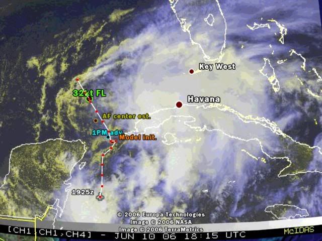
 :lol:

SXXX50 KNHC 101913
AF301 01AAA INVEST HDOB 22 KNHC
1906 2000N 08558W 00207 5056 192 017 256 232 017 00159 0000000000
1906. 1959N 08558W 00212 5056 195 016 256 232 017 00164 0000000000
1907 1957N 08558W 00211 5055 194 016 256 234 017 00163 0000000000
1907. 1956N 08558W 00210 5056 191 017 256 236 017 00163 0000000000
1908 1954N 08558W 00210 5056 184 018 252 242 018 00162 0000000000
1908. 1953N 08558W 00212 5055 187 018 250 244 018 00165 0000000000
1909 1952N 08558W 00210 5055 186 017 250 242 017 00163 0000000000
1909. 1950N 08559W 00210 5055 183 017 250 244 017 00163 0000000000
1910 1949N 08558W 00211 5054 179 018 250 244 018 00165 0000000000
1910. 1947N 08558W 00210 5054 181 018 250 244 019 00163 0000000000
1911 1946N 08558W 00211 5054 180 018 250 242 019 00165 0000000000
1911. 1945N 08558W 00209 5054 177 018 248 238 018 00163 0000000000
1912 1943N 08558W 00212 5053 178 018 246 238 018 00167 0000000000
1912. 1942N 08558W 00209 5053 179 018 246 240 019 00164 0000000000
1913 1940N 08558W 00211 5053 178 017 246 242 017 00166 0000000000
1913. 1939N 08558W 00210 5053 179 016 246 240 016 00166 0000000000
1914 1938N 08558W 00210 5052 180 016 244 240 017 00166 0000000000
1914. 1936N 08558W 00212 5052 182 016 242 240 016 00168 0000000000
1915 1935N 08558W 00210 5052 182 015 242 236 015 00166 0000000000
1915. 1933N 08558W 00210 5052 181 015 240 234 015 00166 0000000000


But I do know enough to say that this still isn't developing wherever these guys are flying.
0 likes   

User avatar
dixiebreeze
S2K Supporter
S2K Supporter
Posts: 5140
Joined: Wed Sep 03, 2003 5:07 pm
Location: crystal river, fla.

#186 Postby dixiebreeze » Sat Jun 10, 2006 2:19 pm

Planning ahead for sure:

WEATHER RECONNAISSANCE FLIGHTS
CARCAH, TPC/NATIONAL HURRICANE CENTER, MIAMI, FL.
1130 AM EDT SAT 10 JUN 2006
SUBJECT: TROPICAL STORM PLAN OF THE DAY (TSPOD)
VALID 11/1100Z TO 12/1100Z JUN 2006
TSPOD NUMBER.....06-009

I. ATLANTIC REQUIREMENTS
1. TROPICAL DEPRESSION ONE- GULF OF MEXICO
FLIGHT ONE FLIGHT TWO
A. 11/1200-1800Z A. 12/0000Z
B. AFXXX 0201A CYCLONE B. NOAA9 0301A CYCLONE
C. 11/0915Z C. 11/1830Z
D. 24.7N AND 86.8W D. N/A
E. 11/1100 TO 1800Z E. N/A
F. SFC TO 10,000FT F. 41,000 TO 45,000FT
FLIGHT THREE
A. 12/0000-0600Z
B. AFXXX 0401A CYCLONE
C. 11/2130Z
D. 26.4N AND 86.3W
E. 11/2300Z TO 12/0600Z
F. SFC TO 10,000FT
2. OUTLOOK FOR SUCCEEDING DAY: CONTINUE 6 HRLY FIXES AS LONG AS
THE SYSTEM IS A THREAT, PROBABLE GIV MISSION FOR 13/0000Z.
0 likes   

jkt21787
Category 5
Category 5
Posts: 2061
Joined: Tue Aug 31, 2004 5:27 pm
Location: Memphis, TN

#187 Postby jkt21787 » Sat Jun 10, 2006 2:19 pm

Air Force Met wrote:
Extremeweatherguy wrote:Is everybody missing my post? I am not posting my opinion. The NHC is saying that the center is now at 22.6N/86.3W.


That's not the NHC...that is Air Force Sat. estimates!

That is also the center of the shear line...there is no defined center in that location.

LOL. I'm seeing tons of center position opinions, and like vbhoutex said in another thread, people are picking their 'preferred' one. Its pretty funny to watch all this unfold I must admit...,

EDIT...Sorry it was Cycloneye who said that.
Last edited by jkt21787 on Sat Jun 10, 2006 2:24 pm, edited 1 time in total.
0 likes   

User avatar
WindRunner
Category 5
Category 5
Posts: 5806
Age: 34
Joined: Fri Jul 29, 2005 8:07 pm
Location: Warrenton, VA, but Albany, NY for school
Contact:

#188 Postby WindRunner » Sat Jun 10, 2006 2:20 pm

brunota2003 wrote:
thunderchief wrote:HURAKAN, they are trying to find a center of circulation, and there are south winds, west of cuba, and HH usually will avoid flying over land masses.
If I remember correctly, they will fly over land masses, just not drop the dropsondes...however Cuba is a "no-fly" zone to U.S. aircraft unless they get special permission...feel free to correct me if I am wrong...


Cuba is no-fly for us (most of the time, they made an exception for Dennis missions last year), but the AF tries to stay out of storms over land, especially strong ones, as the land will often cause turbulence that beats the planes up even more.
0 likes   

User avatar
Extremeweatherguy
Category 5
Category 5
Posts: 11095
Joined: Mon Oct 10, 2005 8:13 pm
Location: Florida

#189 Postby Extremeweatherguy » Sat Jun 10, 2006 2:21 pm

TreasureIslandFLGal wrote:When did the NHC ever say that? They are still sampling the area. There are many vortices right now spinning around a large low pressure area.
You've posted the same thing like 8 times already on a number of threads. What do you want, everyone to say yes Extremeweatherguy you are absolutely correct! You have been saying "watch out TX!!!" for days now.
Calm down already. The situation is unfolding and a very young storm is developing. It's only the first one of the season. Relax or you're gonna give yourself a heart attack... and the rest of us a migraine. :roll:
actually no I have not been saying, "watch out TX!!!" for days now. In fact, I have never said this was coming to TX. I may have said it could get as far west as TX as my range of error, but that is not the same as saying it is coming to TX.
0 likes   

User avatar
vacanechaser
Category 5
Category 5
Posts: 1461
Joined: Wed Dec 03, 2003 9:34 pm
Location: Portsmouth, Va
Contact:

#190 Postby vacanechaser » Sat Jun 10, 2006 2:22 pm

Evil Jeremy wrote:
Bgator wrote:I agree with you, if the center in near cozumel, this storm is nothing, there is barley any convection there, just a spin, the Cuban spin is more reasonable as all the convection is there, also this has seemed to flare down since this morning is this normal, will it reflare up tonight?


its probally because of the eye replacement.


i hope your kidding about the eye... no such thing in a t.d. ... that happens in mature major hurricanes where the eyewall replacement takes place.. if thats what you mean..

look, there are several circulations around this thing right now, and until we get a dominant center, it will continue to drive us crazy...once the shear relaxes, we will have a better idea... i dont believe there is anything near the surface closer to cuba.. the center appears to be the one closer to the peninsula and further northwest than thought...


Jesse V. Bass III
http://www.vastormphoto.com
Hurricane Intercept Research Team
0 likes   
Jesse V. Bass III
http://www.vastormphoto.com
Hurricane Intercept Research Team

User avatar
P.K.
Professional-Met
Professional-Met
Posts: 5149
Joined: Thu Sep 23, 2004 5:57 pm
Location: Watford, England
Contact:

#191 Postby P.K. » Sat Jun 10, 2006 2:27 pm

1006hPa

URNT11 KNHC 101913
97779 19134 70197 86000 02100 18016 24248 /0006
41915
RMK AF301 01AAA INVEST OB 10
0 likes   

User avatar
WindRunner
Category 5
Category 5
Posts: 5806
Age: 34
Joined: Fri Jul 29, 2005 8:07 pm
Location: Warrenton, VA, but Albany, NY for school
Contact:

#192 Postby WindRunner » Sat Jun 10, 2006 2:28 pm

SXXX50 KNHC 101923
AF301 01AAA INVEST HDOB 23 KNHC
1916 1932N 08559W 00210 5052 180 014 242 230 014 00167 0000000000
1916. 1930N 08559W 00210 5052 180 014 242 226 014 00166 0000000000
1917 1929N 08559W 00211 5052 180 013 242 222 013 00167 0000000000
1917. 1928N 08559W 00211 5052 180 013 240 226 013 00167 0000000000
1918 1926N 08559W 00210 5052 182 012 240 228 012 00167 0000000000
1918. 1925N 08559W 00211 5052 185 012 238 232 012 00167 0000000000
1919 1923N 08559W 00210 5052 184 012 240 232 012 00167 0000000000
1919. 1922N 08559W 00211 5051 184 011 240 240 011 00168 0000000000
1920 1920N 08559W 00209 5051 182 010 240 240 011 00166 0000000000
1920. 1919N 08600W 00211 5051 180 010 240 236 011 00168 0000000000
1921 1918N 08601W 00210 5051 183 009 240 238 009 00167 0000000000
1921. 1916N 08601W 00210 5051 183 009 240 236 009 00167 0000000000
1922 1915N 08602W 00210 5051 188 009 240 234 009 00168 0000000000
1922. 1914N 08602W 00210 5051 191 009 240 234 009 00167 0000000000
1923 1912N 08602W 00211 5051 190 008 240 234 008 00168 0000000000
1923. 1911N 08603W 00210 5051 187 008 240 236 008 00167 0000000000
1924 1909N 08603W 00211 5051 193 007 238 236 007 00169 0000000000
1924. 1908N 08603W 00210 5051 202 007 236 236 007 00167 0000000000
1925 1906N 08603W 00210 5051 210 007 236 236 007 00168 0000000000
1925. 1905N 08603W 00211 5051 219 007 236 236 007 00168 0000000000

Still heading south.

EDIT: maybe checking out that thing east of Belieze? Don't know why they would want to.
And Argentina just put in a nice goal a few minutes ago . . . :)
Last edited by WindRunner on Sat Jun 10, 2006 2:30 pm, edited 1 time in total.
0 likes   

mtm4319
Category 5
Category 5
Posts: 1537
Joined: Sun Sep 12, 2004 2:47 am
Location: Mobile, AL

#193 Postby mtm4319 » Sat Jun 10, 2006 2:30 pm

They're heading into the other little ball of convection... I think we were calling it 'center #4' a few hours ago. :P

Image
(refresh if needed - I've added a couple other center estimates)
0 likes   

Matt-hurricanewatcher

#194 Postby Matt-hurricanewatcher » Sat Jun 10, 2006 2:30 pm

The interesting thing is that ball of convection seems to be being sucked to the small LLC. That is my seconding guest on the formation of this system.
0 likes   

Johnny
Category 5
Category 5
Posts: 1428
Joined: Thu Jul 10, 2003 1:35 pm
Location: No Snow For You, Texas

#195 Postby Johnny » Sat Jun 10, 2006 2:32 pm

Ease up on EWG. He has been pretty informative at this point. I have read all of his opinions and no, he has not said, "Watch Out Texas." No where close to it to be honest with you. Talk about putting words in someones mouth. He said the farthest he sees this going west is the Houston/Galveston area but probablyunlikely. Keep it up EWG, you're doing good bro.
0 likes   

rockyman
Category 5
Category 5
Posts: 1967
Joined: Thu Jun 26, 2003 12:24 pm
Location: Dauphin Island, AL

#196 Postby rockyman » Sat Jun 10, 2006 2:35 pm

New QuikScat pretty much says it all:

http://manati.orbit.nesdis.noaa.gov/dat ... MBas75.png
0 likes   

User avatar
WindRunner
Category 5
Category 5
Posts: 5806
Age: 34
Joined: Fri Jul 29, 2005 8:07 pm
Location: Warrenton, VA, but Albany, NY for school
Contact:

#197 Postby WindRunner » Sat Jun 10, 2006 2:37 pm

rockyman wrote:New QuikScat pretty much says it all:

http://manati.orbit.nesdis.noaa.gov/dat ... MBas75.png


That's two hours old, came out before the intermediate advisory (though it wasn't used in it).

It does however support the NHC's 2pm position, or a little more south. Good call on their part.
Last edited by WindRunner on Sat Jun 10, 2006 2:38 pm, edited 2 times in total.
0 likes   

User avatar
Bgator
Category 2
Category 2
Posts: 649
Joined: Mon Sep 05, 2005 12:29 pm
Location: Orlando, FL

#198 Postby Bgator » Sat Jun 10, 2006 2:37 pm

rockyman wrote:New QuikScat pretty much says it all:

http://manati.orbit.nesdis.noaa.gov/dat ... MBas75.png


Yup center in between the 2, and major winds dislocted to the south of cuba and east of the storm! They need to head over there!!
0 likes   

User avatar
WindRunner
Category 5
Category 5
Posts: 5806
Age: 34
Joined: Fri Jul 29, 2005 8:07 pm
Location: Warrenton, VA, but Albany, NY for school
Contact:

#199 Postby WindRunner » Sat Jun 10, 2006 2:41 pm

SXXX50 KNHC 101933
AF301 01AAA INVEST HDOB 24 KNHC
1926 1903N 08603W 00210 5051 223 007 236 234 007 00168 0000000000
1926. 1902N 08603W 00211 5051 225 007 236 234 008 00168 0000000000
1927 1900N 08603W 00210 5051 231 007 236 232 007 00168 0000000000
1927. 1859N 08603W 00211 5050 233 007 236 232 007 00169 0000000000
1928 1857N 08603W 00210 5050 235 008 236 232 008 00168 0000000000
1928. 1856N 08603W 00210 5050 231 008 236 236 009 00169 0000000000
1929 1854N 08603W 00210 5050 231 009 236 236 009 00168 0000000000
1929. 1853N 08603W 00213 5050 232 010 236 236 011 00171 0000000000
1930 1851N 08602W 00208 5050 233 011 236 236 012 00167 0000000000
1930. 1850N 08602W 00210 5050 232 011 232 232 011 00169 0000000000
1931 1849N 08601W 00209 5049 236 009 234 234 011 00167 0000000000
1931. 1848N 08603W 00212 5049 235 010 234 234 013 00172 0000000000
1932 1847N 08604W 00210 5049 236 012 230 230 012 00169 0000000000
1932. 1847N 08605W 00210 5049 239 011 230 226 012 00169 0000000000
1933 1846N 08607W 00213 5048 239 009 230 224 010 00173 0000000000
1933. 1845N 08607W 00207 5048 245 012 226 226 012 00167 0000000000
1934 1843N 08608W 00212 5048 251 011 226 226 011 00172 0000000000
1934. 1842N 08609W 00210 5047 260 011 228 228 011 00171 0000000000
1935 1841N 08610W 00211 5047 260 010 230 224 011 00171 0000000000
1935. 1840N 08611W 00210 5048 250 010 230 230 011 00171 0000000000

Winds calming down before reaching the convection far to the south.
0 likes   

mtm4319
Category 5
Category 5
Posts: 1537
Joined: Sun Sep 12, 2004 2:47 am
Location: Mobile, AL

#200 Postby mtm4319 » Sat Jun 10, 2006 2:42 pm

Image
0 likes   


Return to “Talkin' Tropics”

Who is online

Users browsing this forum: ElectricStorm and 55 guests