
I'm seeing some feeder bands developing on the south side of this big blob too. This really looks like an organizing trend. Although there still seems to be some shear on the SW side as the blow up of convection can't seem to make much further west of the center. The center seems to be on the SW edge of thuderstorms, from looking at IR-2 imagery.
I would be more concern today for this storm becoming a minimal hurricane before making landfall. It will be another 24 hours or so before this storm even makes close to the coast.
Tropical Storm Alberto
Moderator: S2k Moderators
-
HurricaneHunter914
- Category 5

- Posts: 4439
- Age: 32
- Joined: Fri Mar 10, 2006 7:36 pm
- Location: College Station, TX
A hurricane from Alberto can easily happen. Water Temps can definitly support a minimal hurricane as the shear and dry air start to back off from Alberto.
0 likes
Personal Forecast Disclaimer:
The posts in this forum are NOT official forecast and should not be used as such. They are just the opinion of the poster and may or may not be backed by sound meteorological data. They are NOT endorsed by any professional institution or storm2k.org. For official information, please refer to the NHC and NWS products.
The posts in this forum are NOT official forecast and should not be used as such. They are just the opinion of the poster and may or may not be backed by sound meteorological data. They are NOT endorsed by any professional institution or storm2k.org. For official information, please refer to the NHC and NWS products.
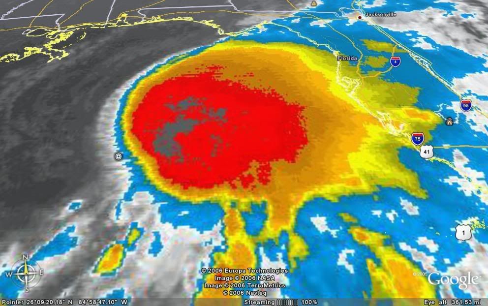

Ok, now I'm getting concerned - is this thing lazarus or what? Looking at the IR, it now looks like the LLC has tucked itself underneath the heavy convection to the NE of the old location and the new center would be east of the forecasted NHC points. Its hard with the IR, but it wouldn't surprise me if the center is relocated next advisory. What this means is scary - ole AL could get stronger and I hope it doesn't reach hurricane status. 
http://www.ssd.noaa.gov/goes/east/gmex/loop-avn.html
http://www.ssd.noaa.gov/goes/east/gmex/loop-avn.html
0 likes
-
HurricaneHunter914
- Category 5
- Posts: 4439
- Age: 32
- Joined: Fri Mar 10, 2006 7:36 pm
- Location: College Station, TX
A relocation of the center under the convection would mean bad news for FL, but luckily shear is helping us out.
0 likes
Personal Forecast Disclaimer:
The posts in this forum are NOT official forecast and should not be used as such. They are just the opinion of the poster and may or may not be backed by sound meteorological data. They are NOT endorsed by any professional institution or storm2k.org. For official information, please refer to the NHC and NWS products.
The posts in this forum are NOT official forecast and should not be used as such. They are just the opinion of the poster and may or may not be backed by sound meteorological data. They are NOT endorsed by any professional institution or storm2k.org. For official information, please refer to the NHC and NWS products.
-
Grease Monkey

- Category 2

- Posts: 727
- Joined: Fri Jun 09, 2006 9:25 pm
http://www.weather.com/maps/news/atlsto ... mated.html
It definitely looks like it centered itself much better.
It definitely looks like it centered itself much better.
Last edited by Grease Monkey on Mon Jun 12, 2006 5:42 am, edited 1 time in total.
0 likes
You can see the center way out on NWS Tampa Radar:
http://weather.noaa.gov/radar/latest/DS ... ktbw.shtml
http://weather.noaa.gov/radar/latest/DS ... ktbw.shtml
0 likes
-
HurricaneHunter914
- Category 5
- Posts: 4439
- Age: 32
- Joined: Fri Mar 10, 2006 7:36 pm
- Location: College Station, TX
HURAKAN wrote:
If Alberto can relocate its center into the middle of that blob, we've got an instant hurricane.
0 likes
Personal Forecast Disclaimer:
The posts in this forum are NOT official forecast and should not be used as such. They are just the opinion of the poster and may or may not be backed by sound meteorological data. They are NOT endorsed by any professional institution or storm2k.org. For official information, please refer to the NHC and NWS products.
The posts in this forum are NOT official forecast and should not be used as such. They are just the opinion of the poster and may or may not be backed by sound meteorological data. They are NOT endorsed by any professional institution or storm2k.org. For official information, please refer to the NHC and NWS products.
-
Grease Monkey
- Category 2
- Posts: 727
- Joined: Fri Jun 09, 2006 9:25 pm
-
HURAKAN

- Professional-Met

- Posts: 46084
- Age: 39
- Joined: Thu May 20, 2004 4:34 pm
- Location: Key West, FL
- Contact:
Everyday since the storm formed a lot of people have been giving their opinion on what will happen with the storm. So far, the NHC has been right and most of people's predictions have been wrong. We always value your opinions and you have the right to post them, nevertheless, if you don't have hard evidence to go against the NHC's forecast, please keep it to yourself. Moreover, a message from Alberto, "Por favor, no me sigan matando cada noche," "Please, don't continue killing me every night."
0 likes
-
HurricaneHunter914
- Category 5
- Posts: 4439
- Age: 32
- Joined: Fri Mar 10, 2006 7:36 pm
- Location: College Station, TX
-
Stratusxpeye

- Category 2
- Posts: 686
- Joined: Tue Jun 07, 2005 10:40 am
- Location: Tampa, Florida
- Contact:


At this point, the shear is going to start meaning less and less as long as convection can continue to fire. It is the type os situation that if the center stays under the convection, then I see every reason why this will become a minimal hurricane before landfall. It is all up to the convection. The latest large range radar from Tampa is hiniting at an eyewall.
0 likes
-
HurricaneHunter914
- Category 5
- Posts: 4439
- Age: 32
- Joined: Fri Mar 10, 2006 7:36 pm
- Location: College Station, TX
You stay safe over there Stratusxpeye, having one tornado in your area is bad, two tornadoes is DANGEROUS.
0 likes
Personal Forecast Disclaimer:
The posts in this forum are NOT official forecast and should not be used as such. They are just the opinion of the poster and may or may not be backed by sound meteorological data. They are NOT endorsed by any professional institution or storm2k.org. For official information, please refer to the NHC and NWS products.
The posts in this forum are NOT official forecast and should not be used as such. They are just the opinion of the poster and may or may not be backed by sound meteorological data. They are NOT endorsed by any professional institution or storm2k.org. For official information, please refer to the NHC and NWS products.
-
Grease Monkey
- Category 2
- Posts: 727
- Joined: Fri Jun 09, 2006 9:25 pm
HurricaneHunter914 wrote:Right now around 83 degrees.
http://www.weather.com/maps/geography/o ... large.html
Higher than I thought. I was thinking just barely hitting 80.
0 likes
-
HurricaneHunter914
- Category 5
- Posts: 4439
- Age: 32
- Joined: Fri Mar 10, 2006 7:36 pm
- Location: College Station, TX
They've been in the mid-80s ever since June started.
0 likes
Personal Forecast Disclaimer:
The posts in this forum are NOT official forecast and should not be used as such. They are just the opinion of the poster and may or may not be backed by sound meteorological data. They are NOT endorsed by any professional institution or storm2k.org. For official information, please refer to the NHC and NWS products.
The posts in this forum are NOT official forecast and should not be used as such. They are just the opinion of the poster and may or may not be backed by sound meteorological data. They are NOT endorsed by any professional institution or storm2k.org. For official information, please refer to the NHC and NWS products.

drezee wrote:At this point, the shear is going to start meaning less and less as long as convection can continue to fire. It is the type os situation that if the center stays under the convection, then I see every reason why this will become a minimal hurricane before landfall. It is all up to the convection. The latest large range radar from Tampa is hiniting at an eyewall.
This is a prime example of why you don't turn your back on a system in the GOM, regardless of current conditions. If it has time over the water...it has time to explosively develop....even in June!
0 likes
-
HurricaneHunter914
- Category 5
- Posts: 4439
- Age: 32
- Joined: Fri Mar 10, 2006 7:36 pm
- Location: College Station, TX
http://www.ssd.noaa.gov/goes/flt/t1/avn.jpg
Cloud Tops have warmed very, very, very slightly there were more gray areas in the center of the blob earlier.
Cloud Tops have warmed very, very, very slightly there were more gray areas in the center of the blob earlier.
0 likes
Personal Forecast Disclaimer:
The posts in this forum are NOT official forecast and should not be used as such. They are just the opinion of the poster and may or may not be backed by sound meteorological data. They are NOT endorsed by any professional institution or storm2k.org. For official information, please refer to the NHC and NWS products.
The posts in this forum are NOT official forecast and should not be used as such. They are just the opinion of the poster and may or may not be backed by sound meteorological data. They are NOT endorsed by any professional institution or storm2k.org. For official information, please refer to the NHC and NWS products.
Who is online
Users browsing this forum: No registered users and 1 guest