2006 - The Year of the Invest!
Moderator: S2k Moderators
Forum rules

The posts in this forum are NOT official forecasts and should not be used as such. They are just the opinion of the poster and may or may not be backed by sound meteorological data. They are NOT endorsed by any professional institution or STORM2K. For official information, please refer to products from the National Hurricane Center and National Weather Service.
-
AnnularCane

- S2K Supporter

- Posts: 2949
- Joined: Thu Jun 08, 2006 9:18 am
- Location: Wytheville, VA
-
Scorpion
Matt-hurricanewatcher wrote:Maybe not 10 times less faverable. But much less then last year...With tropical waves about 5 to 8 degrees south of last year. Which means theres a stronger Azores high.
1# a fast east to west flow from the Azores high means that waves will likely be moving at over 20 knots this year. At least intill mid August. Which is pretty normal. Also keeps waves from closing off a LLC.
2# This strong azores high also pumps and rechanges the SAL over the eastern Atlatnic.
Also we have a strong tutt this year. If I remember right its like 2000 or 2002 like. Which should keep tropical cyclones from moving across. Alot more recurvers and systems getting sheared.
I believe with the very warm sst's that we will have numbers like 2003,2004...Which where around 15 or 16 named storms.
This is my option...
First of all... we just got out of JUNE. Its uncommon for June to produce any named storms in the first place. Second, nobody said anything about this season being like 2005. Regardless, it only takes a few majors making landfall to make it a bad season. The shear will subside by August, as it should.
0 likes
-
Mike Doran
Another part of this bark but no bite is how active the ITCZ is without bringing about a storm. Presently, for instance, the EPAC ITCZ is quite active. BUT not much activity there for years and there is a drought in the SW. Season is fairly slow. Why?
Thermodynamics would have low pressures run to high. Hot to cold. Why do the clouds stay in a line? Why would energy break off and head toward, say, the Gulf of California. Or not?
This is part of what I want to talk to Mike Watkins about on Thursday.
Thermodynamics would have low pressures run to high. Hot to cold. Why do the clouds stay in a line? Why would energy break off and head toward, say, the Gulf of California. Or not?
This is part of what I want to talk to Mike Watkins about on Thursday.
0 likes
-
Extremeweatherguy

- Category 5

- Posts: 11095
- Joined: Mon Oct 10, 2005 8:13 pm
- Location: Florida
-
Mike Doran
You know, Guy, I don't think 'shear' has anything to do with it. And I hope I am not stumping on anyone's religion when I say that.
For those of you who have questions for me on Thursday, here is a bit of a tease:
http://www.economist.com/science/displa ... id=1714858
I have had long conversations with Professor Dendy Sloan, an expert on methane hydrates. One of the interesting things he talks about is how gas escaping from hydrates which unform in the deeps of the oceans don't go necessarily straight into the atmosphere. There is a living earth part--where life slurps up the methane and quickly metabolizes it to CO2 . . .
What does that have to do with the EPAC and inactivity? There are significant methane hydrate fields all along the Mexican coast leading up to the Gulf of California. I suggest there is a connection between EPAC tropical storms and methane hydrates--and the description of 'shear' confuses the mechanism.
0 likes
-
LSU2001

- S2K Supporter
- Posts: 1711
- Age: 58
- Joined: Sat Sep 11, 2004 11:01 pm
- Location: Cut Off, Louisiana
bigmoney755 wrote:Where would you rank the 1992 hurricane season with 6 named storms? Where would you rank the 1969 hurricane season with 13 named storms?Matt-hurricanewatcher wrote:That this season will not be any where in the same rank as 2005.
I personally would rank the seasons of 1992 and 1969 like this:
1969 slightly above average with one very very bad land falling storm. Camile.
1992 very below average with one very bad land falling storm Andrew.
JMHO,
Tim
0 likes
Personal Forecast Disclaimer:
The posts in this forum are NOT official forecast and should not be used as such. They are NOT endorsed by any professional institution or storm2k.org. For official information, please refer to the NHC and NWS products.
The posts in this forum are NOT official forecast and should not be used as such. They are NOT endorsed by any professional institution or storm2k.org. For official information, please refer to the NHC and NWS products.

-
Mike Doran
1992 was related to Pinatubo and SOx in the atmosphere impacting cloud microphysics in DC fields. This year is a low SOx year so that storms are more at risk to be flooders and stallers. Hence already the rain in the NE. Appreciate that Bret had the same landfalling BP as Andrew BUT Bret's stronger surface winds were much higher and at the surface slower winds. Why? Why did Andrew have the 5 mesovortices buzz sawing at the surface?
Why did Wilma have a 2 mile wide 'eye' at it's blow up? And then a cyclops over Florida?
Until there is in the meteorological community an appreciation for the EMF things going on with cloud dynamics, it is essentially misleading to compare what is going on in a given year.
Almost a perfect circle in the WGOM and a perfect straight line of ITCZ south in the EPAC. This is a classic. The NHC calling perhaps for development in the EPAC but none will be coming. There isn't enough carbonation for a circular event--which is where the hydrates come into it and the hydrology of the Colorado River. The strikes in the CONUS up to 17k event with circular shape in the WGOM. Just beautiful. You have to wonder, w/out an EMF approach, why tropical formation would not occur in the EPAC but would occur farther north in the WGOM. W/ the EMF approach--appreciating varying conductivity impacts, you can see how the line of conductivity differs from the EPAC to WGOM and where the powering displacement currents stem--in the case of the WGOM literally all around it--helping it to form a disk over a line. From there, the pressure features feedback dielectric features that help organize cloud microphysics toward a surface low, and WGOM conditions are carbonated and warm and saline enough to support that low which forms.
http://www.weather.unisys.com/hurricane/sat_ir_a.gif
JMO.
0 likes
-
bigmoney755
-
arcticfire
- Tropical Storm

- Posts: 189
- Joined: Fri Sep 10, 2004 1:58 am
- Location: Anchorage, AK
- Contact:
-
WindRunner

- Category 5
- Posts: 5806
- Age: 35
- Joined: Fri Jul 29, 2005 8:07 pm
- Location: Warrenton, VA, but Albany, NY for school
- Contact:
bigmoney755 wrote:wxmann_91 wrote:Actually, 1969 was a very active season with 18 named storms, 12 hurricanes, and 5 majors.
Go back and read what I said. 13 named storms.
Our lack of technology in 1969 shouldn't have an affect on whatever you are saying. By today's standards, there were eighteen named systems, just some where named "10" and "1", while others had more common names
0 likes
-
bigmoney755

-
cajungal

- Category 5
- Posts: 2341
- Age: 49
- Joined: Sun Mar 14, 2004 9:34 pm
- Location: Schriever, Louisiana (60 miles southwest of New Orleans)
I simply can't keep up with these invests. I keep getting them all mixed up and don't know where each of them are until I go through all those posts. The sheer has been so hostile that is what keeping these invests from developing. It is only July 1st. 2004 started off slow, but we all know what happened. We still got lots of the season left to go and lets just enjoy a little break while it lasts. Because once August and September rolls around, we will have a hard time keeping up.
0 likes
-
Rainband
Re: 2006 - The Year of the Invest!
I think it's just because everyone expects everything to develop and that just isn't the case. It's not going to be another 2005. Yes it may be a busy season butwe can't judge past season vrs this one. . I think those that issue these invests know what they are doing and sometimes they are done for maratime interests and such. . Great Show with JB. BTWMWatkins wrote:It's Invest-O-Rama these days! This reporter asks...why?
I realize this may not be a popular post, because with 2 invests going on we have something to talk about, right?
But looking at the basin tonight, I cannot remember a time where there was so much attention focused on systems with so little going on.
I understand why 93L got tagged. It was a very impressive and well defined wave before it got the daylights sheared out of it.
And I suppose I could give a little bit of a pass on 94L because we know the BOC can spawn stuff on short notice. But even so upper winds were/are very strong and honestly there was not a short-term threat of development yesterday.
And now we have 95L? Seriously? 95L?
With the upper pattern the way it is, and with the global models not picking up on any sort of development, I do have to wonder why we are seeing these invests opened up on these systems.
I seriously do wonder if some rules of engagement have been changed this season...and if we will see an invest opened up on just about every disturbance in 2006.
Or, perhaps it could be a function of having 4 new specialists on board, and this is giving them some experience setting up the models and watching these systems closely. Or perhaps the additional resources are allowing the TPC to spend more time dogging systems in the early going, even if there isn't any specific concern for emminent development.
Perhaps we have invest inflation...an invest just doesn't seem to mean as much as it did in seasons past...at least not so far this year.
MW
****Edited to change 91L to 93L in 4th paragraph*****
0 likes
-
Grease Monkey

- Category 2

- Posts: 727
- Joined: Fri Jun 09, 2006 9:25 pm

-
Rainband
That doesn't usually happen until AugustAquawind wrote:We still have the whole month of July which could be very active.
Could be.. but chances are it won't be. So far everything seems pretty normal. We are gonna need some serious relaxing of the winds out there for it to be very active much less active or normal..
0 likes
You need to remember that the invests are not for the entertainment of folks on this board - they are initiated by NHC or JTWC when they have a disurbance they are interested in. When an invest is started, it triggers special data collection at a number of web sites, including the NRL and FNMOC TC web pages, UW/CIMSS, and others. These web sites provide NHC and JTWC with things like microwave data processing, and AMSU analyses over the disturbance that would not be available any other way. An invest may represent nothing more than a desire on the part of the forecaster to see microwave imagery, for example. Or in a non-tropical low, the AMSU data to investigate the development of an upper warm core.
These invests don't "cost" anything (even the disk space the imagery generates gets recycled), so who cares if a million of them get started.
These invests don't "cost" anything (even the disk space the imagery generates gets recycled), so who cares if a million of them get started.
0 likes
-
Extremeweatherguy
- Category 5
- Posts: 11095
- Joined: Mon Oct 10, 2005 8:13 pm
- Location: Florida
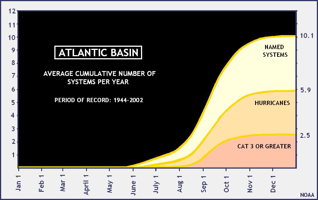
On average...by the end of July we should have 2 named storms in the Atlantic. Since we had a storm in June already, I would estimate we have 1-2 storms this July.
http://www.nhc.noaa.gov/gifs/pastprofileAT.gif
http://www.nhc.noaa.gov/gifs/pastprofileAT.gif
0 likes
Who is online
Users browsing this forum: No registered users and 52 guests