SST'S and Anomalies in Atlantic Thread #4

This is the general tropical discussion area. Anyone can take their shot at predicting a storms path.

Moderator: S2k Moderators

Forum rules

The posts in this forum are NOT official forecasts and should not be used as such. They are just the opinion of the poster and may or may not be backed by sound meteorological data. They are NOT endorsed by any professional institution or STORM2K. For official information, please refer to products from the National Hurricane Center and National Weather Service.

Help Support Storm2K
Message
Author
CHRISTY

#101 Postby CHRISTY » Mon Jul 03, 2006 2:17 pm

SST'S

Image

Image
0 likes   

User avatar
SouthFloridawx
S2K Supporter
S2K Supporter
Posts: 8346
Age: 46
Joined: Tue Jul 26, 2005 1:16 am
Location: Sarasota, FL
Contact:

#102 Postby SouthFloridawx » Mon Jul 03, 2006 2:18 pm

CHRISTY wrote:SST'S

Image

Image


Yep it's that time of year. :D
0 likes   

whereverwx
Category 5
Category 5
Posts: 1109
Joined: Mon May 31, 2004 10:15 pm

#103 Postby whereverwx » Mon Jul 03, 2006 2:25 pm

cycloneye wrote:Image

:uarrow: :uarrow: :uarrow: :uarrow: :uarrow: :uarrow:

Wow,incredible those North Atlantic readings.

Wow, that's pretty amazing! And here's a small archive!
Image Image Image
Image Image Image
0 likes   

User avatar
Aquawind
Category 5
Category 5
Posts: 6714
Age: 62
Joined: Mon Jun 16, 2003 10:41 pm
Location: Salisbury, NC
Contact:

#104 Postby Aquawind » Mon Jul 03, 2006 2:41 pm

Overall it's pretty warm, but the MDR isn't to freaky hot..

Most of the warm anomalies near Canada and the NE are in waters that are WAYYY to cold for true tropical development or even to sustain a warm core system.. The Waters along the NE around New York are still very cold, but come Prime Time no doubt a system will have more energy to work with even if it transitioning to subtropical.

http://www.nhc.noaa.gov/tafb/atl_anal.gif
0 likes   

User avatar
windycity
S2K Supporter
S2K Supporter
Posts: 461
Joined: Wed Aug 24, 2005 6:45 pm
Location: P.B.county,Fl.
Contact:

#105 Postby windycity » Tue Jul 04, 2006 12:32 pm

WOW, CHECK OUT THE LOOP CURRENT AND THE ENTIRE GOM BASIN! wATCH OUT ONCE SHEAR LESSENS! :blowup: :blowup:
0 likes   

User avatar
cycloneye
Admin
Admin
Posts: 146154
Age: 69
Joined: Thu Oct 10, 2002 10:54 am
Location: San Juan, Puerto Rico

#106 Postby cycloneye » Tue Jul 04, 2006 12:37 pm

windycity wrote:WOW, CHECK OUT THE LOOP CURRENT AND THE ENTIRE GOM BASIN! wATCH OUT ONCE SHEAR LESSENS! :blowup: :blowup:


Gulf of Mexico

:uarrow: :uarrow: :uarrow:

Here it is.
0 likes   
Visit the Caribbean-Central America Weather Thread where you can find at first post web cams,radars
and observations from Caribbean basin members Click Here

no advance
Category 1
Category 1
Posts: 413
Joined: Wed Aug 24, 2005 1:50 pm
Location: merritt is.

#107 Postby no advance » Tue Jul 04, 2006 12:41 pm

Went longboarding yesterday. The water is warm. Melted my wax off the board. 83 or so
0 likes   

User avatar
SouthFloridawx
S2K Supporter
S2K Supporter
Posts: 8346
Age: 46
Joined: Tue Jul 26, 2005 1:16 am
Location: Sarasota, FL
Contact:

#108 Postby SouthFloridawx » Tue Jul 04, 2006 12:57 pm

cycloneye wrote:
windycity wrote:WOW, CHECK OUT THE LOOP CURRENT AND THE ENTIRE GOM BASIN! wATCH OUT ONCE SHEAR LESSENS! :blowup: :blowup:


Gulf of Mexico

:uarrow: :uarrow: :uarrow:

Here it is.


Thanks for the graphic... I forgot about that site. It appears there are a couple of areas there where we would have to worry about rapid intesification if there was low shear and a storm moved through those swaths of very warm waters.
0 likes   

User avatar
benny
Category 2
Category 2
Posts: 593
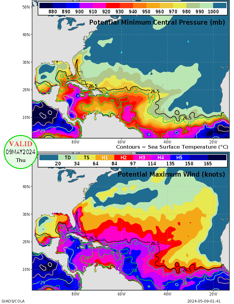
Joined: Sun Mar 19, 2006 8:09 am
Location: Miami

#109 Postby benny » Wed Jul 05, 2006 9:30 am

The warm SSTs at high latitudes are interesting... but I'm not sure they mean anything. It does seem like there is a mild correlation with active seasons... other really warm years up in the Canadian maritimes in June from 40n-60n between 40w-70w include 2005, 1998, 1989, 1979, 1960, and 1951-55... most of those were pretty active with a fair number of landfalls in the US (if it might mean anything).

More interesting to me is the very persistent Atlantic ridge... http://www.cpc.ncep.noaa.gov/products/h ... 00_30d.gif

That ridge is much stronger than average and hasn't allowed the deep tropical Atlantic to warm up much at all. Granted the anomalies are still about 1 standard deviation above average with all the trades.. and if they ever cease I bet things would warm in a hurry (aka 2004).

Despite the strong trades.. the 30 day shear:
http://www.cpc.ncep.noaa.gov/products/h ... _30d.shtml

The zero line is averaging about 20n...pointing to African waves starting to develop as soon as some instability criteria is met (and less of the big dryness on the water vapor) and if the ridge backs off some the low-level environment will likely become more cyclonic and less dry/stable air will be advected in from the ne atlantic.
0 likes   

User avatar
Hurricaneman
Category 5
Category 5
Posts: 7390
Age: 45
Joined: Tue Aug 31, 2004 3:24 pm
Location: central florida

#110 Postby Hurricaneman » Wed Jul 05, 2006 9:39 pm

The north atlantic has some really high anomolies
0 likes   

User avatar
skysummit
S2K Supporter
S2K Supporter
Posts: 5305
Age: 49
Joined: Tue Aug 31, 2004 11:09 pm
Location: Ponchatoula, LA
Contact:

#111 Postby skysummit » Wed Jul 05, 2006 9:48 pm

...and KABOOM goes the Gulf! LOL SSTs are only 1 part of cyclone formation, but it looks like to me the fuel is there, and there's plenty of it. If we don't get a few weaker systems in the gulf to churn that water up a bit before the big party starts next month, the gulf coast could be in LOTS of danger.

Image
0 likes   

User avatar
Tampa Bay Hurricane
Category 5
Category 5
Posts: 5597
Age: 37
Joined: Fri Jul 22, 2005 7:54 pm
Location: St. Petersburg, FL

#112 Postby Tampa Bay Hurricane » Wed Jul 05, 2006 9:49 pm

Very warm ssts in the Caribbean and GOM...shear may tear apart systems
early this season, but that will allow ssts to continue rising....leaving the
conditions conducive for intense storms during August-September. This
idea was mentioned by many members during the past week. If the
ssts continue to rise, very intense storms are likely later this season
once the shear lessens.
0 likes   

User avatar
skysummit
S2K Supporter
S2K Supporter
Posts: 5305
Age: 49
Joined: Tue Aug 31, 2004 11:09 pm
Location: Ponchatoula, LA
Contact:

#113 Postby skysummit » Wed Jul 05, 2006 9:51 pm

Tampa Bay Hurricane wrote:Very warm ssts in the Caribbean and GOM...shear may tear apart systems
early this season, but that will allow ssts to continue rising....leaving the
conditions conducive for intense storms during August-September. This
idea was mentioned by many members during the past week. If the
ssts continue to rise, very intense storms are likely later this season
once the shear lessens.


I highly agree...and the shear will lessen. It's only a matter of time. I'm afraid we'll be seeing a few monsters that are comparible to last year's.
0 likes   

User avatar
Tampa Bay Hurricane
Category 5
Category 5
Posts: 5597
Age: 37
Joined: Fri Jul 22, 2005 7:54 pm
Location: St. Petersburg, FL

#114 Postby Tampa Bay Hurricane » Wed Jul 05, 2006 9:55 pm

That approximately triangle-shaped dark spot just off the west coast of Florida that can support 170 mph to 190 mph winds (the dark blue spot that can support 150 knot- to 165 knot winds)
concerns me...
0 likes   

User avatar
skysummit
S2K Supporter
S2K Supporter
Posts: 5305
Age: 49
Joined: Tue Aug 31, 2004 11:09 pm
Location: Ponchatoula, LA
Contact:

#115 Postby skysummit » Wed Jul 05, 2006 9:57 pm

...and it's only going to get worst as the weeks go by. The waters off the coast of the Florida Panhandle are already in the lower 90's.
0 likes   

HurricaneHunter914
Category 5
Category 5
Posts: 4439
Age: 31
Joined: Fri Mar 10, 2006 7:36 pm
Location: College Station, TX

#116 Postby HurricaneHunter914 » Wed Jul 05, 2006 10:42 pm

Wow, the MJO is favorable, the dry air is diminishing, shear is starting ot relax, and now the water is HOT! Man if only this was August, any TD would have become a major in one second.
0 likes   
Personal Forecast Disclaimer:
The posts in this forum are NOT official forecast and should not be used as such. They are just the opinion of the poster and may or may not be backed by sound meteorological data. They are NOT endorsed by any professional institution or storm2k.org. For official information, please refer to the NHC and NWS products.

User avatar
Aquawind
Category 5
Category 5
Posts: 6714
Age: 62
Joined: Mon Jun 16, 2003 10:41 pm
Location: Salisbury, NC
Contact:

#117 Postby Aquawind » Tue Jul 11, 2006 6:59 am

Definately cooler than last year.. Lotsa cool pockets..Don't worry Freaks there is plenty of heat out there for action..


http://www.nhc.noaa.gov/tafb/atl_anom.gif
0 likes   

User avatar
Cyclenall
Category 5
Category 5
Posts: 6667
Joined: Thu Jun 08, 2006 10:01 pm
Location: Ontario, Canada

#118 Postby Cyclenall » Tue Jul 11, 2006 9:41 am

Aquawind wrote:Definately cooler than last year.. Lotsa cool pockets..Don't worry Freaks there is plenty of heat out there for action..


http://www.nhc.noaa.gov/tafb/atl_anom.gif

There's some cool pockets where hurricanes don't tend to form, go, and explode. There are a few near Africa making the CV season less crazy then 2004 possibly. However, I just think they will bomb once they get closer to land.
0 likes   

User avatar
P.K.
Professional-Met
Professional-Met
Posts: 5149
Joined: Thu Sep 23, 2004 5:57 pm
Location: Watford, England
Contact:

#119 Postby P.K. » Wed Jul 12, 2006 3:51 am

CURRENT STATUS as at 12th July 2006
Next update expected by 26th July 2006 (two weeks after this update).

| Summary | In Brief | Details |

Summary: A persistence of neutral ENSO conditions

The overall ENSO status remains neutral. Generally weak trends have been observed in the main Pacific climate indicators during the past few weeks, and the potential for an El Niño event to develop this year is still relatively low.

The main concern remains the Southern Oscillation Index (SOI), which is hovering around the −10 mark, indicating a general weakness in the Pacific Walker Circulation. There has also been some weakening in the Trade Winds in the last week, so this situation will be monitored closely for any sustained trends. However, ocean temperatures are only marginally above average, both on and below the surface, so there is only a slight risk that the Pacific will warm to levels high enough for an El Niño event to develop.

Most of the ENSO prediction models surveyed at the end of June showed a continuation of neutral conditions, although on the warm side of normal. Some updated model runs since then, indicate an increased likelihood of the Pacific warming to El Niño levels. However, a sustained warming beginning in July or August would be unusual, given that ENSO events typically begin to evolve between March and June.
0 likes   

pup55
Tropical Low
Tropical Low
Posts: 42
Joined: Wed Aug 24, 2005 12:24 pm

#120 Postby pup55 » Wed Jul 12, 2006 5:49 am

Got a question:

Is there any source of data for water temperature at various depths below the surface?

GOM surface temperatures are obviously not too much higher than normal at the moment, but there is a limit as to how high surface temperature will get, due to issues like currents, night time cooling, etc. Example: The Persian Gulf SST's do not get much higher than the GOM despite higher air temperatures.

But, all of that extra energy is hitting the gulf, and should be going somewhere. It would be interesting to know if the sublayer a few feet down is heating up, thus storing up energy at a higher rate than normal.
0 likes   


Return to “Talkin' Tropics”

Who is online

Users browsing this forum: duilaslol, Pelicane, Sps123 and 46 guests