
Tropical Depression Bud (03E) in EPAC
Moderator: S2k Moderators
Forum rules

The posts in this forum are NOT official forecasts and should not be used as such. They are just the opinion of the poster and may or may not be backed by sound meteorological data. They are NOT endorsed by any professional institution or STORM2K. For official information, please refer to products from the National Hurricane Center and National Weather Service.
-
CrazyC83
- Professional-Met

- Posts: 34308
- Joined: Tue Mar 07, 2006 11:57 pm
- Location: Deep South, for the first time!
NOT AN OFFICIAL FORECAST - just my prediction.
I'm quite aggressive on this prediction again. I'm boldly thinking this will be a monster in the ocean.
Current - 14.6/114.1 - 975mb - 90mph
12 hrs - 15.1/115.6 - 962mb - 115mph
24 hrs - 15.9/117.4 - 943mb - 145mph
36 hrs - 16.6/119.5 - 937mb - 140mph
48 hrs - 17.1/121.8 - 945mb - 125mph
60 hrs - 17.3/123.6 - 956mb - 110mph
72 hrs - 17.4/125.8 - 968mb - 105mph
96 hrs - 17.6/129.5 - 969mb - 100mph
120 hrs - 17.5/133.7 - 981mb - 75mph
0 likes

-
HurricaneHunter914
- Category 5

- Posts: 4439
- Age: 32
- Joined: Fri Mar 10, 2006 7:36 pm
- Location: College Station, TX
Here are my chances:
Tropical Storm - 100%
Hurricane - 100%
Major Hurricane - 80%
Cat-5 - 20%
Tropical Storm - 100%
Hurricane - 100%
Major Hurricane - 80%
Cat-5 - 20%
0 likes
Personal Forecast Disclaimer:
The posts in this forum are NOT official forecast and should not be used as such. They are just the opinion of the poster and may or may not be backed by sound meteorological data. They are NOT endorsed by any professional institution or storm2k.org. For official information, please refer to the NHC and NWS products.
The posts in this forum are NOT official forecast and should not be used as such. They are just the opinion of the poster and may or may not be backed by sound meteorological data. They are NOT endorsed by any professional institution or storm2k.org. For official information, please refer to the NHC and NWS products.
-
HouTXmetro

- Category 5
- Posts: 3949
- Joined: Sun Jun 13, 2004 6:00 pm
- Location: District of Columbia, USA
-
HURAKAN

- Professional-Met
- Posts: 46086
- Age: 38
- Joined: Thu May 20, 2004 4:34 pm
- Location: Key West, FL
- Contact:
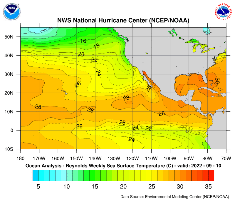
HouTXmetro wrote:Why would it weaken over the open Pacific being that it's not gaining much lattitude?
http://www.nhc.noaa.gov/tafb/pac_anal.gif
This map could answer your question.
Always remember that the EPAC has a current called "California Current" that takes the cold water from the northern Pacific toward warmer latitudes, therefore, the EPAC cannot get very warm passed 20ºN. The same happens in the Atlantic in the eaternside, which is less familiar to us, but we have the "Canary Islands Current" which takes the cold water from the north Atlantic toward warmer latitudes. Therefore, the waters of the northeastern coast of Africa and the coast of Europe are cold.

BLUE ARROWS: COLD WATER CURRENT
RED ARROWS: HOT WATER CURRENT
0 likes
-
HURAKAN
- Professional-Met
- Posts: 46086
- Age: 38
- Joined: Thu May 20, 2004 4:34 pm
- Location: Key West, FL
- Contact:
I know everyone here is excited because Bud has suddenly become a hurricane, but don't let the horses get in front of the carriage. First, the NHC has a lot of experience with storms like Bud. Second, since the storm suddenly erupted, the intensity of its convective patten has diminished a lot, as you can see in the image below. Third, the system is nearing cold waters, therefore, I think 115 mph as a forecast in not conservative since the storm is not even showing signs of going through an EWRC as the eye has remained intact.


0 likes
Why is dry air entering the system when there is no dry air around it? Just look:
http://www.goes.noaa.gov/browsp3.html
Can someone explain this because I can't figure it out. It appears that sharp dry air entered into the system yet there isn't any dry air around it!
http://www.goes.noaa.gov/browsp3.html
Can someone explain this because I can't figure it out. It appears that sharp dry air entered into the system yet there isn't any dry air around it!
0 likes
-
Scorpion
-
Matt-hurricanewatcher
-
curtadams
- S2K Supporter

- Posts: 1122
- Joined: Sun Aug 28, 2005 7:57 pm
- Location: Orange, California
- Contact:
Cyclenall wrote:Why is dry air entering the system when there is no dry air around it? Just look:
http://www.goes.noaa.gov/browsp3.html
Can someone explain this because I can't figure it out. It appears that sharp dry air entered into the system yet there isn't any dry air around it!
The satellite measurements show you (kind of) average water throughout the atmosphere. You can still have dry layers - particularly under high clouds.
0 likes
curtadams wrote:Cyclenall wrote:Why is dry air entering the system when there is no dry air around it? Just look:
http://www.goes.noaa.gov/browsp3.html
Can someone explain this because I can't figure it out. It appears that sharp dry air entered into the system yet there isn't any dry air around it!
The satellite measurements show you (kind of) average water throughout the atmosphere. You can still have dry layers - particularly under high clouds.
That's the first time I have ever heard that. So is dry air effecting this storm then?
0 likes
-
Matt-hurricanewatcher

-
whereverwx
- Category 5
- Posts: 1109
- Joined: Mon May 31, 2004 10:15 pm

This reminds me of what Beta did last year just before crossing the Nicaragua coast -- its overall structure improved, including an eye clearing out, but the orange and red cloud tops (as shown on the AVN images) started to disappear at the same time. It peaked at 115 mph for a mere 3 hours before starting to weaken, probably due to land interaction. Since there's no land in Bud's path, it might continue to strengthen for a little while longer (and I see some of the reds near the center coming back). But I think the odds are at least slight that Bud might not become a cat 2 until sometime Wednesday afternoon.
0 likes

Statement as of 2:00 am PDT on July 12, 2006
the convection surrounding the slightly elliptical eye has deepened
during the past several hours. However...SSMI imagery at 0353z
revealed that the eyewall was slightly open to the northwest... and
a burst of convection in the southeastern eyewall has very recently
obscured the eye in infrared imagery. The upper-level outflow is
well-established in all directions...with perhaps just a subtle
restriction to the east due to the outflow from developing Tropical
Storm Carlotta. Other than that...with the center of Carlotta about
650 N mi east of the eye of Bud...the cyclones appear to be
sufficiently separated such that significant interaction between
them is not likely to occur. Dvorak estimates at 06z were 77-90
kt... and the advisory intensity is raised to 85 kt...but the
recent trends in satellite imagery might be signs that Bud has
peaked in intensity.
Bud continues moving along the previous advisory track at about
290/11. Water vapor imagery reveals a mid- to upper-level
vorticity maximum near 30n 130w associated with a weakness in the
subtropical ridge extending westward from northern Mexico. The
global models forecast little movement of that feature during the
next couple of days...after which time the subtropical ridge should
build westward over the Pacific. Bud should not be affected much by
that weakness before it disappears...so a continued
west-northwestward track is forecast for the next 48-72 hours...
followed by a westward turn south of the building ridge. The models
that have a decent representation of the hurricane... such as the
GFDL...UKMET...and NOGAPS anticipate Bud to maintain its current
heading longer than in earlier runs...and the new official forecast
follows suit. Along this more northerly track...Bud will be
reaching the sharp SST gradient in less than 36 hours...and the
SSTs will be gradually on the decline until then that time...so the
new official forecast peaks lower at 90 kt during the next 24 hours
and also shows a more rapid decline beyond that time.
Forecast positions and Max winds
initial 12/0900z 15.0n 115.3w 85 kt
12hr VT 12/1800z 15.7n 117.0w 90 kt
24hr VT 13/0600z 16.6n 119.4w 90 kt
36hr VT 13/1800z 17.5n 121.7w 75 kt
48hr VT 14/0600z 18.5n 124.1w 60 kt
72hr VT 15/0600z 19.5n 128.5w 45 kt
96hr VT 16/0600z 19.5n 132.5w 35 kt
120hr VT 17/0600z 19.0n 136.0w 30 kt
$$
forecaster Knabb
0 likes
Who is online
Users browsing this forum: Google Adsense [Bot] and 46 guests