Tropical Depression Bud (03E) in EPAC

This is the general tropical discussion area. Anyone can take their shot at predicting a storms path.

Moderator: S2k Moderators

Forum rules

The posts in this forum are NOT official forecasts and should not be used as such. They are just the opinion of the poster and may or may not be backed by sound meteorological data. They are NOT endorsed by any professional institution or STORM2K. For official information, please refer to products from the National Hurricane Center and National Weather Service.

Help Support Storm2K
Message
Author
User avatar
WxGuy1
Professional-Met
Professional-Met
Posts: 538
Joined: Sat Oct 22, 2005 12:55 pm
Location: Oklahoma

#161 Postby WxGuy1 » Wed Jul 12, 2006 12:21 pm

Weatherfreak000 wrote:I think I can with safety say the "Major Cat 4" predictions given earlier just aren't going to happen.


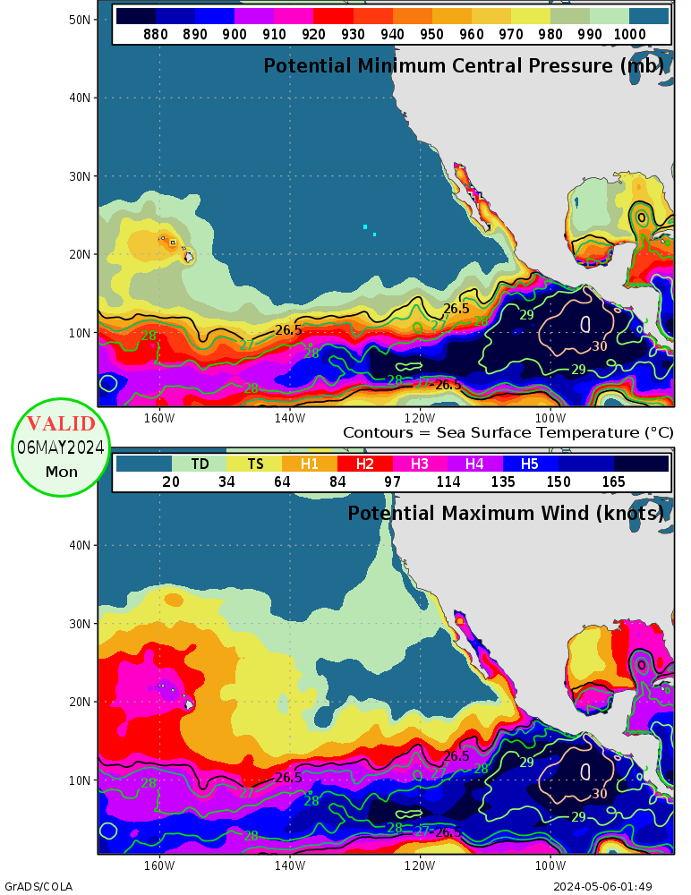
SSTs don't really support a storm that strong:

SST map

Maximum Potential Intensity

Tropical Cyclone Heat Potential

As you can see, the TCHP is much less over that part of the Pacific than it is over the GoM and Caribbean (and western Pacific, for that matter). Any storm really needs to be south of 15N if it's west of 120W to have much of an opportunity to become a major hurricane. That's partly the reason why it's difficult to get a hurricane or even a strong tropical storm into Hawaii, and it's probably easiest if the cyclone comes at Hawaii from the south or southwest.
0 likes   

Air Force Met
Military Met
Military Met
Posts: 4372
Age: 56
Joined: Tue Jul 08, 2003 9:30 am
Location: Roan Mountain, TN

#162 Postby Air Force Met » Wed Jul 12, 2006 12:25 pm

HurricaneHunter914 wrote:Well there really isn't much of an cleared eye though, the eye needs to clear up if Bud wants to strengthen.


Well...a clearing eye is just an indication of a strengthing storm...it has no bearing on the strengthening itself.
0 likes   

Air Force Met
Military Met
Military Met
Posts: 4372
Age: 56
Joined: Tue Jul 08, 2003 9:30 am
Location: Roan Mountain, TN

#163 Postby Air Force Met » Wed Jul 12, 2006 12:27 pm

Weatherfreak000 wrote:I think I can with safety say the "Major Cat 4" predictions given earlier just aren't going to happen.


I agree...the heat potential is just way too low. It bursted yesterday when it went over the higher TCHP...but now its moving over some lower values.
0 likes   

User avatar
cycloneye
Admin
Admin
Posts: 145950
Age: 69
Joined: Thu Oct 10, 2002 10:54 am
Location: San Juan, Puerto Rico

#164 Postby cycloneye » Wed Jul 12, 2006 2:09 pm


12/1800 UTC 16.0N 116.8W T4.5/4.5 BUD -- East Pacific Ocean
0 likes   
Visit the Caribbean-Central America Weather Thread where you can find at first post web cams,radars
and observations from Caribbean basin members Click Here

User avatar
Thunder44
Category 5
Category 5
Posts: 5922
Age: 44
Joined: Mon Jun 09, 2003 7:53 pm
Location: New York City

#165 Postby Thunder44 » Wed Jul 12, 2006 2:42 pm

Latest visible imagery shows the eye clearing out again and deep convection increasing around the center. Could it be another rapid intensification trend beginning?
0 likes   

User avatar
cycloneye
Admin
Admin
Posts: 145950
Age: 69
Joined: Thu Oct 10, 2002 10:54 am
Location: San Juan, Puerto Rico

#166 Postby cycloneye » Wed Jul 12, 2006 2:50 pm

http://tcweb.fnmoc.navy.mil/tc-bin/tc_home.cgi

NRL has Bud at 90kts,970 mbs at 18:00z.
0 likes   

User avatar
Cyclenall
Category 5
Category 5
Posts: 6667
Joined: Thu Jun 08, 2006 10:01 pm
Location: Ontario, Canada

#167 Postby Cyclenall » Wed Jul 12, 2006 3:00 pm

Thunder44 wrote:Latest visible imagery shows the eye clearing out again and deep convection increasing around the center. Could it be another rapid intensification trend beginning?

I sure hope so. I want to see a tiny, intense hurricane Bud. The eye is indeed getting more round and clear which is good news for Bud. I don't think 90 Knots cuts it for Bud currently. Some would argue a 100-Knot storm but I say he is at 95-Knots.
0 likes   

User avatar
cycloneye
Admin
Admin
Posts: 145950
Age: 69
Joined: Thu Oct 10, 2002 10:54 am
Location: San Juan, Puerto Rico

#168 Postby cycloneye » Wed Jul 12, 2006 3:32 pm

903
WTPZ23 KNHC 122031
TCMEP3
HURRICANE BUD FORECAST/ADVISORY NUMBER 9
NWS TPC/NATIONAL HURRICANE CENTER MIAMI FL EP032006
2100 UTC WED JUL 12 2006

HURRICANE CENTER LOCATED NEAR 16.3N 117.5W AT 12/2100Z
POSITION ACCURATE WITHIN 20 NM

PRESENT MOVEMENT TOWARD THE WEST-NORTHWEST OR 295 DEGREES AT 13 KT

ESTIMATED MINIMUM CENTRAL PRESSURE 970 MB
MAX SUSTAINED WINDS 90 KT WITH GUSTS TO 110 KT.
64 KT....... 20NE 20SE 20SW 20NW.
50 KT....... 40NE 40SE 40SW 40NW.
34 KT....... 60NE 60SE 60SW 60NW.
12 FT SEAS..200NE 200SE 125SW 125NW.
WINDS AND SEAS VARY GREATLY IN EACH QUADRANT. RADII IN NAUTICAL
MILES ARE THE LARGEST RADII EXPECTED ANYWHERE IN THAT QUADRANT.

REPEAT...CENTER LOCATED NEAR 16.3N 117.5W AT 12/2100Z
AT 12/1800Z CENTER WAS LOCATED NEAR 16.0N 116.9W

FORECAST VALID 13/0600Z 17.2N 119.3W
MAX WIND 85 KT...GUSTS 105 KT.
64 KT... 20NE 20SE 20SW 20NW.
50 KT... 40NE 40SE 40SW 40NW.
34 KT... 60NE 60SE 60SW 60NW.

FORECAST VALID 13/1800Z 18.4N 122.0W
MAX WIND 75 KT...GUSTS 90 KT.
64 KT... 20NE 20SE 20SW 20NW.
50 KT... 40NE 40SE 40SW 40NW.
34 KT... 60NE 60SE 60SW 60NW.

FORECAST VALID 14/0600Z 19.5N 124.6W
MAX WIND 65 KT...GUSTS 80 KT.
64 KT... 20NE 0SE 0SW 20NW.
50 KT... 40NE 20SE 20SW 40NW.
34 KT... 60NE 60SE 60SW 60NW.

FORECAST VALID 14/1800Z 20.1N 126.7W
MAX WIND 50 KT...GUSTS 60 KT.
50 KT... 20NE 0SE 0SW 20NW.
34 KT... 50NE 50SE 50SW 50NW.

FORECAST VALID 15/1800Z 21.0N 131.0W
MAX WIND 40 KT...GUSTS 50 KT.
34 KT... 50NE 25SE 25SW 50NW.

EXTENDED OUTLOOK. NOTE...ERRORS FOR TRACK HAVE AVERAGED NEAR 200 NM
ON DAY 4 AND 225 NM ON DAY 5...AND FOR INTENSITY NEAR 20 KT EACH DAY

OUTLOOK VALID 16/1800Z 21.0N 135.0W
MAX WIND 30 KT...GUSTS 40 KT.

OUTLOOK VALID 17/1800Z 21.0N 139.0W
MAX WIND 30 KT...GUSTS 40 KT.

REQUEST FOR 3 HOURLY SHIP REPORTS WITHIN 300 MILES OF 16.3N 117.5W

NEXT ADVISORY AT 13/0300Z

$$
FORECASTER MAINELLI/PASCH


353
WTPZ43 KNHC 122037
TCDEP3
HURRICANE BUD DISCUSSION NUMBER 9
NWS TPC/NATIONAL HURRICANE CENTER MIAMI FL EP032006
200 PM PDT WED JUL 12 2006

BUD HAS BEEN ABLE TO MAINTAIN AN EYE FEATURE FOR THE PAST SIX HOURS
AND CLOUD TOPS HAVE REMAINED COLD. DVORAK CURRENT INTENSITIES ARE
90 KT AND 77 KT FROM TAFB AND SAB RESPECTIVELY...AND OBJECTIVE
DVORAK ESTIMATES FOR THE PAST SIX HOURS HAVE AVERAGED AROUND 90 KT.
BASED ON THIS INFORMATION...THE INITIAL INTENSITY HAS INCREASED TO
90 KT. THIS PEAK INTENSITY SHOULD BE RELATIVELY SHORT-LIVED AS THE
HURRICANE IS EXPECTED TO MOVE OVER COOLER WATERS AND INTO A MORE
STABLE AIR MASS IN 12-24 HOURS. THE OFFICIAL FORECAST CALLS FOR
GRADUAL WEAKENING THROUGH FIVE DAYS AND IS A BLEND OF SHIPS AND FSU
SUPER-ENSEMBLE GUIDANCE. A 14Z QUIKSCAT PASS REVEALED SMALLER WIND
RADII AND THE IN ITAL AND FORECAST VALUES REFLECT THIS NEW WIND
FIELD DATA.

THE INITIAL FORWARD SPEED...13 KT...IS SLIGHTLY FASTER THAN IN THE
PREVIOUS ADVISORY AND THE HEADING CONTINUES TOWARD THE WEST-
NORTHWEST. STEERING CONDITIONS REMAIN THE SAME...A WEAKNESS IN THE
RIDGE AND A MID-LEVEL VORTICITY MAXIMUM EXISTS TO THE NORTHWEST OF
THE HURRICANE BETWEEN 125W AND 130W. SUBSEQUENTLY A CONTINUED
WEST-NORTHWESTWARD MOTION IS FORECAST WITH SOME SLOWING OF FORWARD
SPEED DUE TO THE WEAKNESS IN THE RIDGE. THE GFS MODEL HAS BEEN
HAVING A DIFFICULT TIME INITIALIZING THE HURRICANE AND LOSES THE
SYSTEM IN 36 HOURS. THE OFFICIAL TRACK IS ONCE AGAIN SLIGHTLY TO
THE NORTH OF THE PREVIOUS ONE AND FAIRLY CLOSE TO THE REMAINDER OF
THE MODEL GUIDANCE.


FORECAST POSITIONS AND MAX WINDS

INITIAL 12/2100Z 16.3N 117.5W 90 KT
12HR VT 13/0600Z 17.2N 119.3W 85 KT
24HR VT 13/1800Z 18.4N 122.0W 75 KT
36HR VT 14/0600Z 19.5N 124.6W 65 KT
48HR VT 14/1800Z 20.1N 126.7W 50 KT
72HR VT 15/1800Z 21.0N 131.0W 40 KT
96HR VT 16/1800Z 21.0N 135.0W 30 KT
120HR VT 17/1800Z 21.0N 139.0W 30 KT

$$
FORECASTER MAINELLI/PASCH

0 likes   
Visit the Caribbean-Central America Weather Thread where you can find at first post web cams,radars
and observations from Caribbean basin members Click Here

Air Force Met
Military Met
Military Met
Posts: 4372
Age: 56
Joined: Tue Jul 08, 2003 9:30 am
Location: Roan Mountain, TN

#169 Postby Air Force Met » Wed Jul 12, 2006 4:20 pm

Cyclenall wrote:
Thunder44 wrote:Latest visible imagery shows the eye clearing out again and deep convection increasing around the center. Could it be another rapid intensification trend beginning?

I sure hope so. I want to see a tiny, intense hurricane Bud. The eye is indeed getting more round and clear which is good news for Bud. I don't think 90 Knots cuts it for Bud currently. Some would argue a 100-Knot storm but I say he is at 95-Knots.


Well...whatever he is at really...he doesn't have long before the fall. Look at all the stable air/strato-cu to the west of him. Won't be long before he starts wrapping some of that into his circulation. He should be crossing the 80F line sometime tomorrow as well and to add insult to injury...he is leaving the area of TCHP behind. Everything now is down hill.

This is the last grasp before the fall. :D
0 likes   

User avatar
cycloneye
Admin
Admin
Posts: 145950
Age: 69
Joined: Thu Oct 10, 2002 10:54 am
Location: San Juan, Puerto Rico

#170 Postby cycloneye » Wed Jul 12, 2006 4:22 pm

And AFM,the forecast reflects that weakening phase as it reaches cooler waters.
0 likes   
Visit the Caribbean-Central America Weather Thread where you can find at first post web cams,radars
and observations from Caribbean basin members Click Here

User avatar
Cyclenall
Category 5
Category 5
Posts: 6667
Joined: Thu Jun 08, 2006 10:01 pm
Location: Ontario, Canada

#171 Postby Cyclenall » Wed Jul 12, 2006 4:41 pm

Air Force Met wrote:Well...whatever he is at really...he doesn't have long before the fall. Look at all the stable air/strato-cu to the west of him. Won't be long before he starts wrapping some of that into his circulation. He should be crossing the 80F line sometime tomorrow as well and to add insult to injury...he is leaving the area of TCHP behind. Everything now is down hill.

This is the last grasp before the fall. :D

I hope Bud takes a page from Epsilon and strengthens over colder water and stable air. I would like that. When Hurricane Epsilon strengthened instead of weakened, did you say beforehand that he will fall?
0 likes   

User avatar
WindRunner
Category 5
Category 5
Posts: 5806
Age: 34
Joined: Fri Jul 29, 2005 8:07 pm
Location: Warrenton, VA, but Albany, NY for school
Contact:

#172 Postby WindRunner » Wed Jul 12, 2006 5:32 pm

Umm, no, I don't think anyone even expected Epsilon to form to tell you the truth . . . remember, the NHC was just as baffled as everyone else and forecasted it to weaken, as it was the only logical thing to do.

Of course, a comparison to Epsilon here is not appropriate as Epsilon had non-tropical origins, and that effects how much the storm reacts to harsh environments according to some.
0 likes   

User avatar
wxmann_91
Category 5
Category 5
Posts: 8013
Age: 34
Joined: Fri Jul 15, 2005 2:49 pm
Location: Southern California
Contact:

#173 Postby wxmann_91 » Wed Jul 12, 2006 5:37 pm

Bud is a small cyclone, prone to rapid intensification changes. I have noticed that its outflow is very strong so that may be cancelling out any negative effects of the stratocumulus. IMHO, intensification to major hurricane strength is possible within the next 24-36 hr followed by steady weakening thereafter. NHC usually doesn't get the 'last gasp' of EPAC hurricanes which can feature a hurricane seemingly embedded in deadly stratocumulus but yet still intensify due to favorable conditions otherwise.
0 likes   

Matt-hurricanewatcher

#174 Postby Matt-hurricanewatcher » Wed Jul 12, 2006 7:06 pm

Here is what I think of how strong it is right now...A Cdo has formed a classic pin hole eye. With 1/2 red/minus 80 cloud tops...I say 105 knots.
0 likes   

Derek Ortt

#175 Postby Derek Ortt » Wed Jul 12, 2006 7:08 pm

The atmosphere was very unstable in Epsilon, which is why it intensified. There is usually a temp inversion above the strato-cu deck, which is very stable and will quickly suppress any deep convection
0 likes   

clfenwi
Category 5
Category 5
Posts: 3331
Joined: Thu Jun 09, 2005 12:54 pm

#176 Postby clfenwi » Wed Jul 12, 2006 7:13 pm

12/2330 UTC 16.7N 118.1W T5.0/5.0 BUD
0 likes   

User avatar
Cyclenall
Category 5
Category 5
Posts: 6667
Joined: Thu Jun 08, 2006 10:01 pm
Location: Ontario, Canada

#177 Postby Cyclenall » Wed Jul 12, 2006 7:16 pm

WindRunner wrote:Umm, no, I don't think anyone even expected Epsilon to form to tell you the truth . . . remember, the NHC was just as baffled as everyone else and forecasted it to weaken, as it was the only logical thing to do.

Yep.

Of course, a comparison to Epsilon here is not appropriate as Epsilon had non-tropical origins, and that effects how much the storm reacts to harsh environments according to some.

I understand this but I was never comparing Epsilon to Bud, that is not appropriate because Epsilon was a different type of TC.

Bud looks better right now then he has ever been. They eye is great looking now finally and I can tell just by looking at the SAT images that he has deep convection around the eye. I would peg his strength at 100-knots right now. I hope the NHC picks up on what's going on (they do 95% of the time).

I will post more information soon.

The atmosphere was very unstable in Epsilon, which is why it intensified. There is usually a temp inversion above the strato-cu deck, which is very stable and will quickly suppress any deep convection

I never knew that. How do you know if the atmosphere unstable or stable?
Last edited by Cyclenall on Wed Jul 12, 2006 7:35 pm, edited 1 time in total.
0 likes   

clfenwi
Category 5
Category 5
Posts: 3331
Joined: Thu Jun 09, 2005 12:54 pm

#178 Postby clfenwi » Wed Jul 12, 2006 7:30 pm

TPPZ1 KGWC 130025
A. HURRICANE BUD (THREE-E)
B. 12/2331Z (48)
C. 16.7N/4
D. 118.2W/2
E. ONE/GOES11
F. T5.0/5.0/D0.5/24HRS/STT: D1.0/06HRS -12/2331Z-
G. IR/EIR/VIS/MSI

07A/ PBO 10NM RGD EYE/ANMTN. OW EYE IS SURROUNDED BY A 45NM
WIDE LG RING GIVING AN EYE NBR OF 5.0 WITH ZERO EYE ADJ...FOR A
CF/DT OF 5.0. FT IS BASED ON DT...BOTH MET AND PT AGREE.

AODT: T5.0 (CLR EYE)

LAURENTI
0 likes   

User avatar
cycloneye
Admin
Admin
Posts: 145950
Age: 69
Joined: Thu Oct 10, 2002 10:54 am
Location: San Juan, Puerto Rico

#179 Postby cycloneye » Wed Jul 12, 2006 8:31 pm

http://www.nrlmry.navy.mil/tc_pages/tc_home.html

NRL has at 00:00z Bud at 95kts.
0 likes   
Visit the Caribbean-Central America Weather Thread where you can find at first post web cams,radars
and observations from Caribbean basin members Click Here

User avatar
Cyclenall
Category 5
Category 5
Posts: 6667
Joined: Thu Jun 08, 2006 10:01 pm
Location: Ontario, Canada

#180 Postby Cyclenall » Wed Jul 12, 2006 8:46 pm

cycloneye wrote:http://www.nrlmry.navy.mil/tc_pages/tc_home.html

NRL has at 00:00z Bud at 95kts.

He is so close to major hurricane strength. I hope he can pull it off in time...

Right now strong convection is trying to wrap around the eye but it is crushing the eye in the process! :lol:
0 likes   


Return to “Talkin' Tropics”

Who is online

Users browsing this forum: No registered users and 41 guests