Severe weather: NE - Tornado in Metro NYC, injuries reported
Moderator: S2k Moderators
Forum rules

The posts in this forum are NOT official forecast and should not be used as such. They are just the opinion of the poster and may or may not be backed by sound meteorological data. They are NOT endorsed by any professional institution or STORM2K.
-
CrazyC83
- Professional-Met

- Posts: 34315
- Joined: Tue Mar 07, 2006 11:57 pm
- Location: Deep South, for the first time!
Severe weather: NE - Tornado in Metro NYC, injuries reported
Tornado Watch out for parts of New York, New Jersey and Pennsylvania. New watches may be issued soon.
Last edited by CrazyC83 on Wed Jul 12, 2006 4:25 pm, edited 1 time in total.
0 likes
-
CrazyC83
- Professional-Met
- Posts: 34315
- Joined: Tue Mar 07, 2006 11:57 pm
- Location: Deep South, for the first time!
This just in...
Tornado Touches Down In Westchester
(CBS) NEW YORK A tornado touched down in southern Westchester County Wednesday afternoon, causing damage. There were also reports of injuries.
The National Weather Service had issued a Tornado Warning until 4:15 p.m. for southern Westchester County. Other severe weather watches and warnings are in effect for portions of the Tri-State area. Forecasters say these storms could produce deadly lightning, strong straight-line winds, torrential downpours, hail and, perhaps, even isolated tornadoes at least through Wednesday evening.
Stay with wcbstv.com, or tune to WCBS-TV, for complete coverage.
(© MMVI, CBS Broadcasting Inc. All Rights Reserved.)
http://wcbstv.com/topstories/local_story_193162354.html
0 likes
-
WindRunner

- Category 5

- Posts: 5803
- Age: 35
- Joined: Fri Jul 29, 2005 8:07 pm
- Location: Warrenton, VA, but Albany, NY for school
- Contact:
Also have a report of a waterspout on the Hudson river, probably the same funnel the story is about, as this report was at 3:40pm, with the report of a tornado in Tarrytown (in southern Westchester Co.) at 3:50pm, followed by an additional report of possible tornado damage in Hawthorne on the other side of the county at 3:55pm. The Hawthorne LSR includes a comment about a building collapsed with people trapped. Haven't seen anything in the media about that yet, though.
0 likes
-
WindRunner
- Category 5
- Posts: 5803
- Age: 35
- Joined: Fri Jul 29, 2005 8:07 pm
- Location: Warrenton, VA, but Albany, NY for school
- Contact:
An update to the story . . . contains some descriptions/pictures that definately sound like a tornado.
Probable Tornado Rocks Southern Westchester County
Westchester OEM: Avoid Route 9A/Saw Mill Corridor
(CBS/AP) NEW YORK A probable tornado touched down northeast of Tarrytown in Westchester County on Wednesday afternoon, causing significant damage.
CBS 2 meteorologist John Bolaris reports witnesses on the ground seeing water spouts, which are tornadoes over water, as the fast-moving storm headed toward Hawthorne just after 3:40 p.m. The U.S. Coast Guard later reported a water spout over Long Island Sound. Despite those reports, the National Weather Service has yet to officially confirm a tornado.
In the wake of the storm, Westchester County opened its Emergency Operations Center Wednesday afternoon. Staff from Westchester County's Department of Public Safety, Emergency Services, Public Works and other major county departments were called in to deal with the response.
There was a partial building collapse with some people trapped for a time at a warehouse in Hawthorne. The owner of the building told CBS 2's Scott Weinberger that all the workers were accounted for and there was one minor injury.
"The building started to shake and the sky got pitch black," the owner said. "Bricks started flying by my car. I've never see anything like that before."
The storm knocked out power to thousands of Westchester residents, said Con Ed spokesman Chris Olert, who said hundreds of Con Ed workers are assessing damages in Tarrytown, Pleasantville and central Westchester, east of Tarrytown. Olert told CBS 2 that hundreds of tress are down. Many have power lines tangled in them. Con Ed is urging anyone who sees a downed power line not to go near it.
The Saw Mill Parkway is closed at the Eastview exit in Hawthorne. Neil Sweeting of the Westchester County Office of Emergency Management said drivers should avoid the area of Route 9A and Saw Mill for the time being. There are reports of flipped over cars on 9A.
The weather knocked down trees, causing some damage to houses and closing roads. There are also reports of damage in Valhalla and Mt. Pleasant.
MetroNorth spokesman Dan Brucker said the violent storm caused Metro North to suspend service -- after two trees fell, blocking both tracks of the Upper Harlem Line between the Valhalla and Hawthorne stations. Trains resumed moving on one track though the area at 5:20 p.m. Brucker said there are delays of up to 15 minutes on trains that are moving. Metro North's Hudson and New Haven train lines are unaffected.
Metro-North train service North of North White Plains was suspended at 3:50 p.m. Hudson and New Haven lines are unaffected. The Harlem line south of the North White Plains station is running.
Due to the severe weather, there is a 2 1/2-hour delay at Newark Liberty Airport and a 1 1/2-hour delay at LaGuardia.
The National Weather Service had issued a Tornado Warning until 4:15 p.m. for southern Westchester County. Other severe weather watches and warnings are in effect for portions of the tri-state area. Forecasters say these storms could produce deadly lightning, strong straight-line winds, torrential downpours, hail and, perhaps, even isolated tornadoes at least through Wednesday evening.
Please check back with WCBSTV.com and CBS 2 for all the latest on this breaking story.
(© 2006 CBS Broadcasting Inc. All Rights Reserved. This material may not be published, broadcast, rewritten, or redistributed. The Associated Press contributed to this report.)
http://wcbstv.com/topstories/local_story_193162950.html
Pictures are in the story at the link above - the third one definately looks like it took a good twist IMO.
0 likes


-
donsutherland1
- S2K Analyst

- Posts: 2718
- Joined: Mon Sep 15, 2003 8:49 pm
- Location: New York
Re: Severe weather: NE - Tornado in Metro NYC, injuries repo
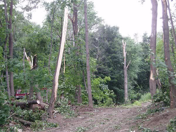
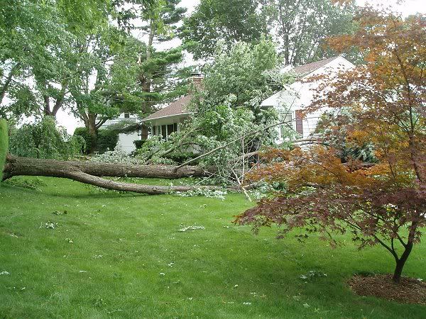
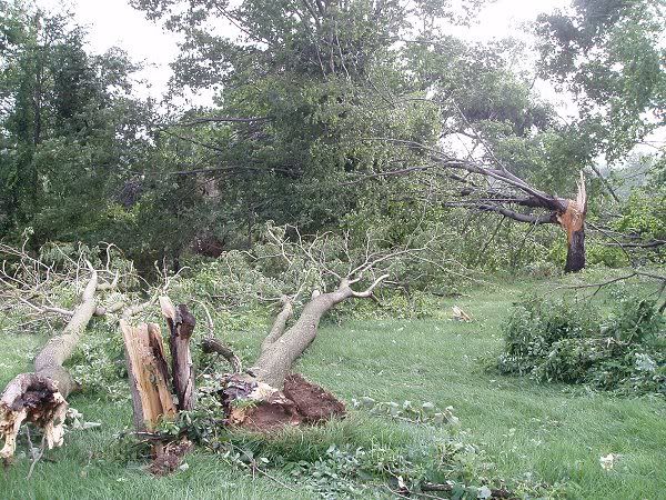
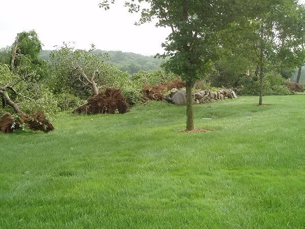
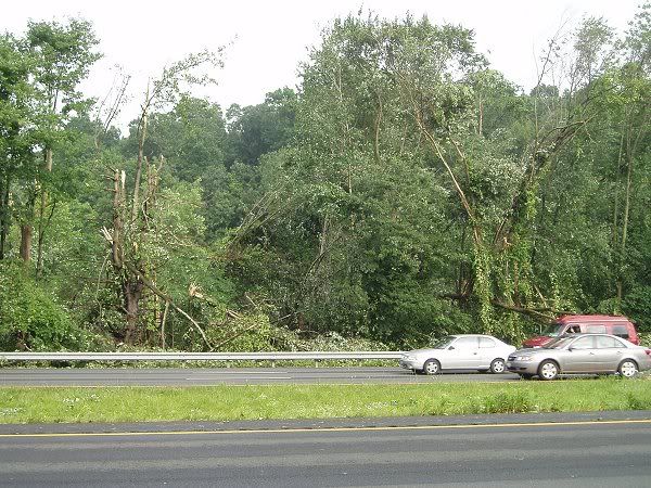
It appears from tree damage--uprooted trees, broken trees, etc.--that stretches in a rather narrow line across the Croton Reservoir (Hawthorne/Valhalla lie on the other side of the Croton Reservoir), across Routes 22, 120, and 684 that a small tornado moved across Westchester County into Fairfield County.
The line of damage is rather narrow--at most a few hundred feet--and is probably not likely to have resulted from straight line winds. Whether it was a funnel cloud or tornado at that point is an entirely different matter.
Around 4 pm:


Around 5 pm:
On either side of Route 120 (Swiss Re and IBM grounds):
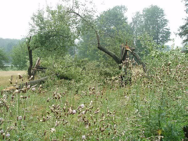
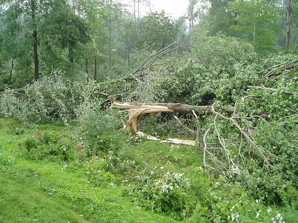
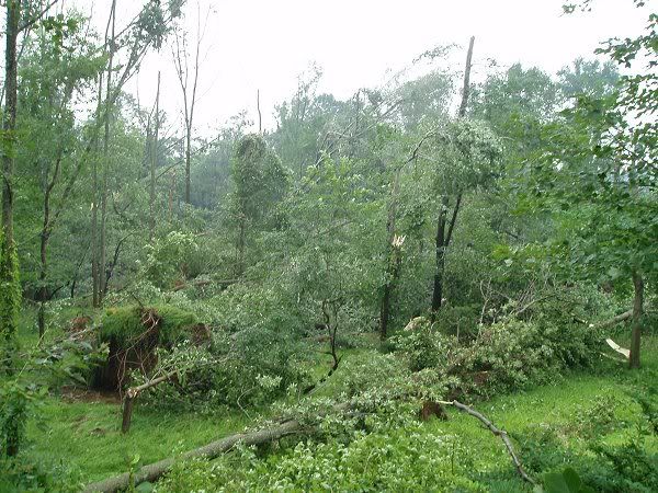

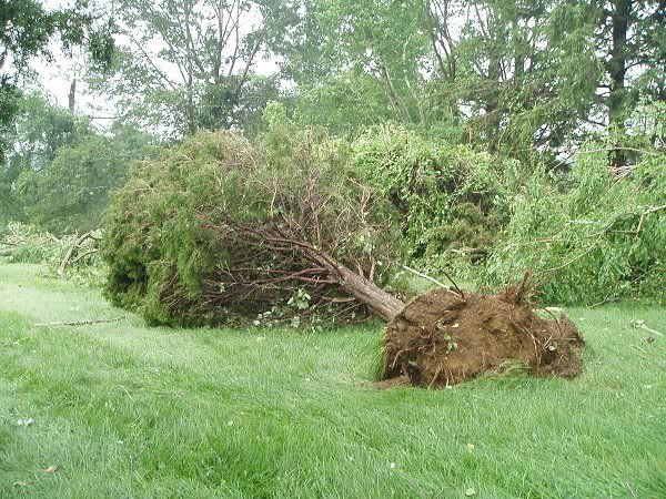
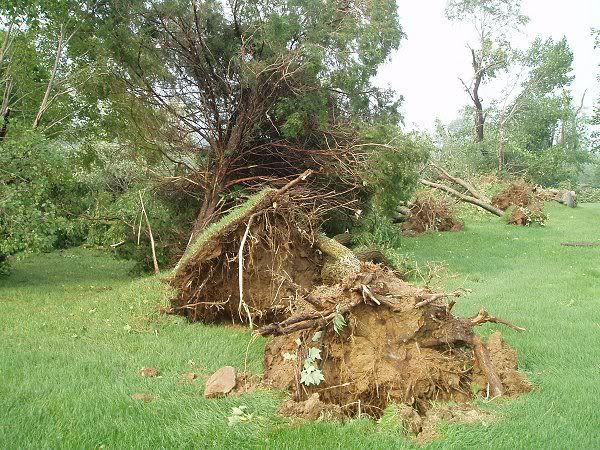
Looking down Route 22 where the system crossed over the Croton Reservoir toward the Swiss Re property:

The line of damage is rather narrow--at most a few hundred feet--and is probably not likely to have resulted from straight line winds. Whether it was a funnel cloud or tornado at that point is an entirely different matter.
Around 4 pm:
Around 5 pm:
On either side of Route 120 (Swiss Re and IBM grounds):
Looking down Route 22 where the system crossed over the Croton Reservoir toward the Swiss Re property:
0 likes
-
Skywatch_NC

- Category 5
- Posts: 10949
- Joined: Wed Feb 05, 2003 9:31 pm
- Location: Raleigh, NC
- Contact:
-
TexasStooge

- Category 5
- Posts: 38127
- Joined: Tue Mar 25, 2003 1:22 pm
- Location: Irving (Dallas County), TX
- Contact:
Here are some viewer submitted pics of the tornado from WCBS sites:


And one from a cell phone on the WNBC site:

You can see a video-clip taken on the cell phone on WNBC site too: http://wnbc.nbcweatherplus.com/weathern ... etail.html
And one from a cell phone on the WNBC site:
You can see a video-clip taken on the cell phone on WNBC site too: http://wnbc.nbcweatherplus.com/weathern ... etail.html
0 likes
-
WindRunner
- Category 5
- Posts: 5803
- Age: 35
- Joined: Fri Jul 29, 2005 8:07 pm
- Location: Warrenton, VA, but Albany, NY for school
- Contact:
000
NOUS41 KOKX 132157
PNSOKX
CTZ005>012-NJZ002>006-011-NYZ067>081-141800-
PUBLIC INFORMATION STATEMENT
NATIONAL WEATHER SERVICE UPTON NY
557 PM EDT THU JUL 13 2006
...F2 TORNADO CONFIRMED IN WESTCHESTER COUNTY...
THE NATIONAL WEATHER SERVICE IN UPTON NEW YORK HAS CONFIRMED THAT A
TORNADO TOUCHED DOWN IN WESTCHESTER COUNTY ON WEDNESDAY JULY 12,
2006. THE TORNADO WAS RATED AS AN F1 IN THE TOWN OF SLEEPY HOLLOW IN
THE SOUTHWEST PORTION OF THE COUNTY...THEN MOVED THROUGH POCANTICO
HILLS WHERE...AT ITS STRONGEST POINT...IT WAS RATED AN F2. IT
CONTINUED MOVING IN AN EASTERLY DIRECTION AS AN F1 THROUGH THE TOWNS
OF HAWTHORNE AND MOUNT PLEASANT. THE TORNADO THEN MOVED INTO THE
KENSICO RESERVOIR...STILL AS AN F1...BEFORE IT MOVED INTO THE
GREENWICH AREA OF FAIRFIELD COUNTY. THE TOTAL PATH LENGTH OF THE
STORM WAS APPROXIMATELY 15 MILES LONG WITH A WIDTH OF 200 TO 300
YARDS.
THE INVESTIGATION IS STILL UNDERWAY IN CONNECTICUT AT THIS TIME.
0 likes
-
donsutherland1
- S2K Analyst
- Posts: 2718
- Joined: Mon Sep 15, 2003 8:49 pm
- Location: New York


-
Weatherfreak14

- Category 5
- Posts: 1381
- Joined: Sat Sep 24, 2005 3:40 pm
- Location: Beaufort, SC
- Contact:
-
michaelwmoss
- Category 2

- Posts: 558
- Joined: Thu Mar 25, 2004 1:56 am
- Location: New Whiteland, IN
- Contact:
Thunder44 wrote:Here are some viewer submitted pics of the tornado from WCBS sites:
And one from a cell phone on the WNBC site:
You can see a video-clip taken on the cell phone on WNBC site too: http://wnbc.nbcweatherplus.com/weathern ... etail.html
Man conditions were HUMID up there. The tornado was ragged and within alot of mist. Classic Summertime Nader
0 likes
-
HurricaneBill
- Category 5
- Posts: 3419
- Joined: Sun Apr 11, 2004 5:51 pm
- Location: East Longmeadow, MA, USA
Last Tuesday (July 11th), there were some powerful thunderstorms in Massachusetts.
The storms produced a microburst and also spawned an F2 tornado in the town of Wendell, MA. There were trees down, power outages, some damage to a few buildings, but fortunately, no injuries or deaths.
The Wendell tornado was the strongest in Massachusetts since the deadly Great Barrington tornado in 1995.
Here in East Longmeadow, I don't know if it was the same storm, but the early evening storm we got was a severe one. Torrential rain and rapid-fire lightning!
0 likes
Return to “USA & Caribbean Weather”
Who is online
Users browsing this forum: Captmorg70, Stratton23 and 113 guests