99L Invest, East Atlantic,Comments,Sat Pics,Models Thread

This is the general tropical discussion area. Anyone can take their shot at predicting a storms path.

Moderator: S2k Moderators

Forum rules

The posts in this forum are NOT official forecasts and should not be used as such. They are just the opinion of the poster and may or may not be backed by sound meteorological data. They are NOT endorsed by any professional institution or STORM2K. For official information, please refer to products from the National Hurricane Center and National Weather Service.

Help Support Storm2K
Message
Author
recmod
Tropical Storm
Tropical Storm
Posts: 214
Joined: Sat Aug 28, 2004 8:57 pm
Location: Orlando, FL
Contact:

#301 Postby recmod » Fri Jul 28, 2006 7:20 am

RQSTR wrote:it's a quiet season despite what we expected... now august approaches, maybe things will change, maybe not.


It is NOT a quiet season so far. Keep in mind, this is only July. Compared to last year, I see where you feel this could be classified as a "quiet season". However, in regards to long-term averages, this year is very close to...or slightly above normal. In June, a tropical cyclone forms on the average of once every two years...we had one this June (Alberto). July normally sees one tropical cyclone in the month....which we have already had (Beryl).
After the insane year we had in 2005, it's so easy to hop on the "This season is a bust" bandwagon. Let's disassociate ourselves from the 2005 anomaly and look at the long term averages when we make broad sweeping comments about the season as a whole. This year is truckin' along just fine. Remember......2004 did not have the first named storm until late on July 31.....we all know where THAT year ended up (Charley, Frances, Ivan & Jeanne)

--Lou
0 likes   

shaggy
Category 2
Category 2
Posts: 655
Joined: Fri Jul 22, 2005 4:14 pm
Location: greenville, n.c.

#302 Postby shaggy » Fri Jul 28, 2006 7:26 am

this system is going to be a tough to figure out for now seems to be getting elongated and there also appears to be a few spins on the first few vis pics.i worked graveyard lastnight so its time to get some sleep and see what it looks like in about 5 hours maybe by then a low will be trying to consolidate itself and show us where this will develop IF it does!
0 likes   

User avatar
wxman57
Moderator-Pro Met
Moderator-Pro Met
Posts: 22978
Age: 67
Joined: Sat Jun 21, 2003 8:06 pm
Location: Houston, TX (southwest)

#303 Postby wxman57 » Fri Jul 28, 2006 7:29 am

SouthFloridawx wrote:
wxman57 wrote:Matt, I must be doing something wrong. I can't find any wind barbs on that web page you posted. I did plot ship reports in GARP but there was nothing anywhere near the disturbance. Heading to the office now, so I'll have more tools to look at it.


Image


Thanks, SouthFlorida. But I can't see that image very well on my laptop. I'm running about 1900x1200 resolution and it's 3 inches across with any ship report about 1/4 inch across.

I did run GARP and can't find any ship reports near the disturbance from 00Z last evening. Satellite imagery indicates it's less organized than it was yesterday. The spin was much more evident before sunset yesterday afternoon. I can see lots of dry air flowing into the northern part of the thunderstorm cluster as well.

There may be a hint of a spin around 9N/36W, but not at the surface.

Chances for development appear to be diminishing.
Last edited by wxman57 on Fri Jul 28, 2006 7:30 am, edited 1 time in total.
0 likes   

User avatar
bvigal
S2K Supporter
S2K Supporter
Posts: 2276
Joined: Sun Jul 24, 2005 8:49 am
Location: British Virgin Islands
Contact:

#304 Postby bvigal » Fri Jul 28, 2006 7:30 am

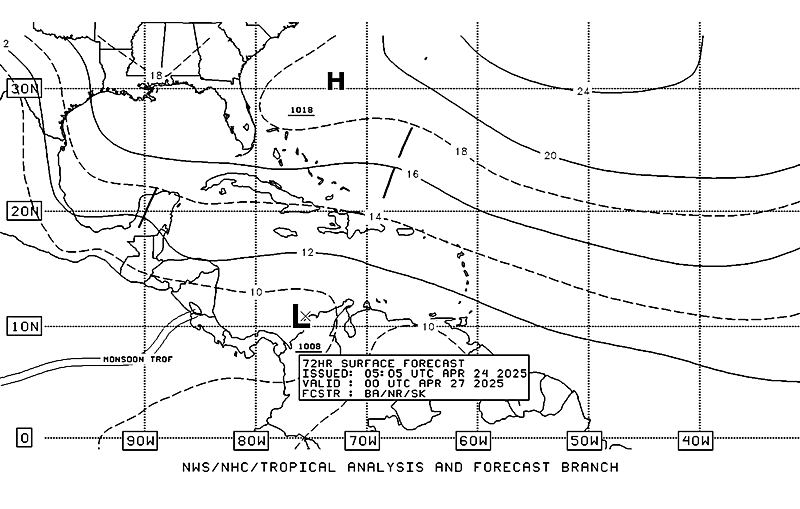
Image
This just released from TAFB. Doesn't look like they really expect any low from this wave in 72hrs.
0 likes   

User avatar
Aquawind
Category 5
Category 5
Posts: 6714
Age: 62
Joined: Mon Jun 16, 2003 10:41 pm
Location: Salisbury, NC
Contact:

#305 Postby Aquawind » Fri Jul 28, 2006 7:47 am

They have been inconsistant wih depicting lows it seems with thier maps from the morning to evening runs. Seems to go back and forth often of late. I will be interested to see the 00Z maps.
0 likes   

User avatar
storms in NC
S2K Supporter
S2K Supporter
Posts: 2338
Joined: Thu Jul 28, 2005 2:58 pm
Location: Wallace,NC 40 miles NE of Wilm
Contact:

#306 Postby storms in NC » Fri Jul 28, 2006 7:51 am

8am

ATLANTIC OCEAN...
THE DOMINANT FEATURE IN THE ATLC IS THE BERMUDA-AZORES RIDGE
WITH THE SFC RIDGE AXIS EXTENDING FROM A 1024 MB HIGH OVER THE
AZORES TO A 1028 MB HIGH NEAR 33N54W ACROSS THE N CENTRAL GULF.
SCATTERED PATCHES OF LOW-MID LEVEL MOISTURE DRIVEN BY MODERATE E
WINDS IS THE THEME ACROSS THE ATLC N OF THE TROPICAL WAVES. THE
ONLY KINK IN THE RIDGE IS A WEAK DRY SFC TROUGH ALONG 35W FROM
24N-29N. IN THE UPPER LEVELS...A MID-UPPER LEVEL NARROW TROUGH
LIES OFF THE E COAST OF THE U.S. PRODUCING A NARROW PLUME OF
HIGH LEVEL MOISTURE W OF 75W. A WEAKENING ELONGATED UPPER LOW IS
N OF THE BAHAMAS NEAR 27N71W INCREASING SHOWER ACTIVITY IN THE
CARIBBEAN AS IT INTERACTS WITH THE TROPICAL WAVE. SEE THE
CARIBBEAN SECTION FOR MORE DETAILS. THE REMAINDER OF ATLC IS
DOMINATED BY A LARGE UPPER RIDGE EXTENDING FROM AFRICA TO 65W.
UPPER DIFFLUENCE BETWEEN THIS RIDGE AND TROUGH N OF THE BAHAMAS
IS PRODUCING AN AREA OF UPPER LEVEL MOISTURE BETWEEN 60W-73W.
MODERATE TO STRONG SUBSIDENCE LIES EAST OF 60W N OF 20N...THIS
DRY STABLE AIR ALOFT IN COMBINATION WITH DENSE SAHARAN DUST IN
THE LOW-MID LEVELS IS SUPPRESSING ANY CONVECTION FROM FORMING IN
THIS REGION.
0 likes   

User avatar
cycloneye
Admin
Admin
Posts: 145308
Age: 68
Joined: Thu Oct 10, 2002 10:54 am
Location: San Juan, Puerto Rico

#307 Postby cycloneye » Fri Jul 28, 2006 8:01 am

DISTURBANCE INVEST (AL992006) ON 20060728 1200 UTC

...00 HRS... ...12 HRS... ...24 HRS... ...36 HRS...
060728 1200 060729 0000 060729 1200 060730 0000

LAT LON LAT LON LAT LON LAT LON
BAMD 8.8N 35.7W 9.3N 39.3W 9.6N 42.4W 9.8N 45.4W
BAMM 8.8N 35.7W 9.4N 39.0W 10.0N 41.9W 10.4N 44.6W
A98E 8.8N 35.7W 8.8N 39.4W 9.1N 42.8W 9.5N 45.9W
LBAR 8.8N 35.7W 9.3N 39.5W 10.1N 43.2W 11.0N 46.7W
SHIP 20KTS 24KTS 30KTS 36KTS
DSHP 20KTS 24KTS 30KTS 36KTS

...48 HRS... ...72 HRS... ...96 HRS... ..120 HRS...
060730 1200 060731 1200 060801 1200 060802 1200

LAT LON LAT LON LAT LON LAT LON
BAMD 10.2N 48.2W 11.5N 53.6W 13.4N 58.7W 15.7N 62.5W
BAMM 11.0N 47.0W 12.7N 51.6W 14.4N 55.5W 15.9N 58.3W
A98E 10.0N 48.4W 11.6N 52.9W 13.6N 57.1W 16.1N 61.0W
LBAR 12.1N 49.8W 15.0N 54.5W 19.2N 56.5W 24.6N 59.1W
SHIP 42KTS 53KTS 55KTS 55KTS
DSHP 42KTS 53KTS 55KTS 55KTS

...INITIAL CONDITIONS...
LATCUR = 8.8N LONCUR = 35.7W DIRCUR = 270DEG SPDCUR = 18KT
LATM12 = 8.8N LONM12 = 31.5W DIRM12 = 272DEG SPDM12 = 17KT
LATM24 = 8.6N LONM24 = 28.7W
WNDCUR = 20KT RMAXWD = 60NM WNDM12 = 20KT
CENPRS = 1009MB OUTPRS = 1011MB OUTRAD = 120NM SDEPTH = D
RD34NE = 0NM RD34SE = 0NM RD34SW = 0NM RD34NW = 0NM


12:00z BAM Models.
0 likes   
Visit the Caribbean-Central America Weather Thread where you can find at first post web cams,radars
and observations from Caribbean basin members Click Here

HurricaneHunter914
Category 5
Category 5
Posts: 4439
Age: 31
Joined: Fri Mar 10, 2006 7:36 pm
Location: College Station, TX

#308 Postby HurricaneHunter914 » Fri Jul 28, 2006 8:14 am

The system is now up to 20 kts. Needs only 5 more kts for the winds to be TD forced.
0 likes   
Personal Forecast Disclaimer:
The posts in this forum are NOT official forecast and should not be used as such. They are just the opinion of the poster and may or may not be backed by sound meteorological data. They are NOT endorsed by any professional institution or storm2k.org. For official information, please refer to the NHC and NWS products.

User avatar
cycloneye
Admin
Admin
Posts: 145308
Age: 68
Joined: Thu Oct 10, 2002 10:54 am
Location: San Juan, Puerto Rico

#309 Postby cycloneye » Fri Jul 28, 2006 8:16 am

Image

12:00z BAM Models Graphic.
0 likes   

User avatar
Extremeweatherguy
Category 5
Category 5
Posts: 11095
Joined: Mon Oct 10, 2005 8:13 pm
Location: Florida

#310 Postby Extremeweatherguy » Fri Jul 28, 2006 8:18 am

In the short term, this system may be affected by too much dry air to really get going, but once it reaches the Caribbean...watch out.
0 likes   

User avatar
Extremeweatherguy
Category 5
Category 5
Posts: 11095
Joined: Mon Oct 10, 2005 8:13 pm
Location: Florida

#311 Postby Extremeweatherguy » Fri Jul 28, 2006 8:19 am

cycloneye wrote:Image

12:00z BAM Models Graphic.
I don't like these models for a weak system like this. I hope the GFS, GFDL and NAM come into play soon.
0 likes   

User avatar
NONAME
Category 1
Category 1
Posts: 373
Age: 35
Joined: Sat Mar 18, 2006 8:15 am
Location: Where the Wind Blows

#312 Postby NONAME » Fri Jul 28, 2006 8:20 am

Um HurricaneHunter914 There is no standard for Wind force for a TD Just if it has a Closed Low level Circulation.
0 likes   

HurricaneHunter914
Category 5
Category 5
Posts: 4439
Age: 31
Joined: Fri Mar 10, 2006 7:36 pm
Location: College Station, TX

#313 Postby HurricaneHunter914 » Fri Jul 28, 2006 8:21 am

http://cimss.ssec.wisc.edu/tropic/real- ... 0split.jpg

SAL shouldn't be much of a problem, if 99L is going to encounter some SAL it will probably be weak.
0 likes   
Personal Forecast Disclaimer:
The posts in this forum are NOT official forecast and should not be used as such. They are just the opinion of the poster and may or may not be backed by sound meteorological data. They are NOT endorsed by any professional institution or storm2k.org. For official information, please refer to the NHC and NWS products.

User avatar
Thunder44
Category 5
Category 5
Posts: 5922
Age: 44
Joined: Mon Jun 09, 2003 7:53 pm
Location: New York City

#314 Postby Thunder44 » Fri Jul 28, 2006 8:21 am

HurricaneHunter914 wrote:The system is now up to 20 kts. Needs only 5 more kts for the winds to be TD forced.


It's been at 20kts since yesterday and it needs a closed surface circulation first which it doesn't appear to have yet. There are really no wind requirements for TDs.
0 likes   

User avatar
cheezyWXguy
Category 5
Category 5
Posts: 6108
Joined: Mon Feb 13, 2006 12:29 am
Location: Dallas, TX

#315 Postby cheezyWXguy » Fri Jul 28, 2006 8:21 am

i dont think this thing will turn that nuch...expect this to move thru most of the carribean...besides, none of the models posted are very good with weaker systems
0 likes   

User avatar
Extremeweatherguy
Category 5
Category 5
Posts: 11095
Joined: Mon Oct 10, 2005 8:13 pm
Location: Florida

#316 Postby Extremeweatherguy » Fri Jul 28, 2006 8:22 am

HurricaneHunter914 wrote:http://cimss.ssec.wisc.edu/tropic/real-time/wavetrak/winds/m8g10split.jpg

SAL shouldn't be much of a problem, if 99L is going to encounter some SAL it will probably be weak.
yeah, that looks like what may be happening this morning. Once it moves out of that area though, I expect this to explode.
0 likes   

User avatar
MortisFL
Category 1
Category 1
Posts: 391
Age: 42
Joined: Mon Jul 21, 2003 9:01 am
Location: Sarasota, FL
Contact:

#317 Postby MortisFL » Fri Jul 28, 2006 8:25 am

Looks like its holding its own pretty well.
0 likes   

User avatar
cheezyWXguy
Category 5
Category 5
Posts: 6108
Joined: Mon Feb 13, 2006 12:29 am
Location: Dallas, TX

#318 Postby cheezyWXguy » Fri Jul 28, 2006 8:25 am

i think this evening well see some better organization
0 likes   

gtsmith
Tropical Storm
Tropical Storm
Posts: 181
Joined: Fri Sep 24, 2004 7:05 am
Location: West Palm Beach, FL

#319 Postby gtsmith » Fri Jul 28, 2006 8:25 am

HurricaneHunter914 wrote:http://cimss.ssec.wisc.edu/tropic/real-time/wavetrak/winds/m8g10split.jpg

SAL shouldn't be much of a problem, if 99L is going to encounter some SAL it will probably be weak.


What i find amazing about the SAL is how quickly it can rebuild. The Puerto Rico/USVI areas were hit yesterday with some really heavy rains, right? Now that whole area is red on the SAL map...but i guess with the moisture moving out it draws the SAL back in behind it?

BTW: 99L is not looking so good on the latest 1.5 hours of sat picks...at least not as impressive as it was yesterday...lokks more like a wave at this point...to my untrained eyes that is.
0 likes   

Air Force Met
Military Met
Military Met
Posts: 4372
Age: 56
Joined: Tue Jul 08, 2003 9:30 am
Location: Roan Mountain, TN

#320 Postby Air Force Met » Fri Jul 28, 2006 8:35 am

HurricaneHunter914 wrote:The system is now up to 20 kts. Needs only 5 more kts for the winds to be TD forced.


Could you explain that to me? I missed that in forecasters school. :lol:
0 likes   


Return to “Talkin' Tropics”

Who is online

Users browsing this forum: Cpv17, Hurricane2022 and 53 guests