MJO
Moderator: S2k Moderators
Forum rules

The posts in this forum are NOT official forecasts and should not be used as such. They are just the opinion of the poster and may or may not be backed by sound meteorological data. They are NOT endorsed by any professional institution or STORM2K. For official information, please refer to products from the National Hurricane Center and National Weather Service.


Any MJO is quite weak. Just because there is green on the 200 mb velocity potential... doesn't mean the MJO is positive. There are a variety of convective modes the atmosphere uses... Kelvin waves for example... and if you look at MJO only, the strength of the MJO is actually much weaker than average even for the summer time. Models are showing a pretty dramatic lowering of pressures Day 8 and beyond in the Atlantic.. so maybe that will herald the start of the tropical wave season.
0 likes
-
gatorcane

- S2K Supporter

- Posts: 23703
- Age: 47
- Joined: Sun Mar 13, 2005 3:54 pm
- Location: Boca Raton, FL
benny wrote:Any MJO is quite weak. Just because there is green on the 200 mb velocity potential... doesn't mean the MJO is positive. There are a variety of convective modes the atmosphere uses... Kelvin waves for example... and if you look at MJO only, the strength of the MJO is actually much weaker than average even for the summer time. Models are showing a pretty dramatic lowering of pressures Day 8 and beyond in the Atlantic.. so maybe that will herald the start of the tropical wave season.
Yes I agree and see these pressure drops. August is right around the corner and we are closing in on it fast - I continue to say this but I expect quite a ramp up in about 2 weeks.....
0 likes
-
'CaneFreak

- Category 5

- Posts: 1487
- Joined: Mon Jun 05, 2006 10:50 am
- Location: New Bern, NC
cycloneye wrote:
The wet phase of MJO has arrived for the most part in the Atlantic Basin.But still the core of this wet phase is in the EPAC.

Not anymore people.....Here we go....Remember the activity in the Pacific last week or so? GET READY....could get real interesting real soon.....I think next week will really start getting crazy...Hope you're ready....
0 likes


-
Extremeweatherguy

- Category 5
- Posts: 11095
- Joined: Mon Oct 10, 2005 8:13 pm
- Location: Florida
I 100% agree. Things are about to get crazy!'CaneFreak wrote:cycloneye wrote:
The wet phase of MJO has arrived for the most part in the Atlantic Basin.But still the core of this wet phase is in the EPAC.
Not anymore people.....Here we go....Remember the activity in the Pacific last week or so? GET READY....could get real interesting real soon.....I think next week will really start getting crazy...Hope you're ready....
0 likes


-
'CaneFreak
- Category 5
- Posts: 1487
- Joined: Mon Jun 05, 2006 10:50 am
- Location: New Bern, NC
-
Hurricaneman

- Category 5
- Posts: 7404
- Age: 45
- Joined: Tue Aug 31, 2004 3:24 pm
- Location: central florida
-
HurricaneHunter914
- Category 5
- Posts: 4439
- Age: 32
- Joined: Fri Mar 10, 2006 7:36 pm
- Location: College Station, TX
Its all in Mother Naturre's hands my friend.
0 likes
Personal Forecast Disclaimer:
The posts in this forum are NOT official forecast and should not be used as such. They are just the opinion of the poster and may or may not be backed by sound meteorological data. They are NOT endorsed by any professional institution or storm2k.org. For official information, please refer to the NHC and NWS products.
The posts in this forum are NOT official forecast and should not be used as such. They are just the opinion of the poster and may or may not be backed by sound meteorological data. They are NOT endorsed by any professional institution or storm2k.org. For official information, please refer to the NHC and NWS products.
-
Hurricaneman
- Category 5
- Posts: 7404
- Age: 45
- Joined: Tue Aug 31, 2004 3:24 pm
- Location: central florida
-
willjnewton
-
cycloneye

- Admin

- Posts: 148755
- Age: 69
- Joined: Thu Oct 10, 2002 10:54 am
- Location: San Juan, Puerto Rico
The dry MJO has entered most of the Atlantic.For the week of the 20th of August another wet phase will enter the Atlantic,it's now in the WPAC where there are three cyclones now.
0 likes
Visit the Caribbean-Central America Weather Thread where you can find at first post web cams,radars
and observations from Caribbean basin members Click Here
and observations from Caribbean basin members Click Here
-
SouthFloridawx

- S2K Supporter
- Posts: 8346
- Age: 47
- Joined: Tue Jul 26, 2005 1:16 am
- Location: Sarasota, FL
- Contact:
Looks like we may have a wet MJO just in time for September and peak season. Of course this is GFS 40 day forecast and is subject to errors but, I'm interested to watch this and see how it changes.
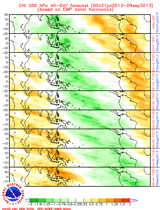
http://www.cpc.ncep.noaa.gov/products/p ... _chi.shtml
http://www.cpc.ncep.noaa.gov/products/p ... _chi.shtml
0 likes
-
Extremeweatherguy
- Category 5
- Posts: 11095
- Joined: Mon Oct 10, 2005 8:13 pm
- Location: Florida
looks like it begins to arrive in as early as 2 weeks.SouthFloridawx wrote:Looks like we may have a wet MJO just in time for September and peak season. Of course this is GFS 40 day forecast and is subject to errors but, I'm interested to watch this and see how it changes.
http://www.cpc.ncep.noaa.gov/products/p ... _chi.shtml
0 likes
-
Derek Ortt
-
SouthFloridawx
- S2K Supporter
- Posts: 8346
- Age: 47
- Joined: Tue Jul 26, 2005 1:16 am
- Location: Sarasota, FL
- Contact:
Derek Ortt wrote:could someone please direct me to peer reviewed literature documenting the influence of the MJO in the Atlantic? Not a random unreviewed website. Thanks
Sorry to offend you
Some of us do not have a formal education and are trying to learn about different subjects. With all due respect, perhaps you may be able to enlighten us on the subject and explain why this is not a graphic I should not be looking in respect of a MJO outlook.
It is the GFS model and it updates daily.
0 likes
-
SouthFloridawx
- S2K Supporter
- Posts: 8346
- Age: 47
- Joined: Tue Jul 26, 2005 1:16 am
- Location: Sarasota, FL
- Contact:
http://www.cpc.ncep.noaa.gov/products/p ... den/Julian Oscillation: Recent Evolution, Current Status and Forecasts
Here is a PPT on from the CPC.
Here is a PPT on from the CPC.
0 likes
-
Derek Ortt
-
SouthFloridawx
- S2K Supporter
- Posts: 8346
- Age: 47
- Joined: Tue Jul 26, 2005 1:16 am
- Location: Sarasota, FL
- Contact:
Who is online
Users browsing this forum: No registered users and 47 guests