forecast highs for my area
Sunday: 94
Monday: 95
Tuesday: 98
Wednesday: 99
Back in the soup
who else is going to get it?
Summer Heat wave thread
Moderator: S2k Moderators
Forum rules

The posts in this forum are NOT official forecast and should not be used as such. They are just the opinion of the poster and may or may not be backed by sound meteorological data. They are NOT endorsed by any professional institution or STORM2K.
-
Jim Cantore
Summer Heat wave thread
Last edited by Jim Cantore on Wed Aug 09, 2006 11:07 pm, edited 3 times in total.
0 likes
-
WindRunner

- Category 5

- Posts: 5803
- Age: 35
- Joined: Fri Jul 29, 2005 8:07 pm
- Location: Warrenton, VA, but Albany, NY for school
- Contact:
Wash/Balt area for sure as well!
We've got:
Sun - 91
Mon - 94
Tues - 98
Wed - 99
Thurs - 94
And believe it or not, Sterling it actually talking about bringing out the excessive heat warning for the cities by Tues. - by LWX standards is a heat index of 106+ for two days or 115F, which I know this is higher than what they use at Mt. Holly. Let's just say it's not something that they use too often.
0 likes
today's high- around 97
sunday- 100
monday- 102
tuesday- 92
wednesday- relief, 83
heat advisory for Minneapolis- St. Paul till monday afternoon/evening with possible getting up to 114 or higher, and night time heat indicies still around 95-100.
and finally current conditions for New Brighton:
temp: 88F (31C)
dewpoint: 79F (26C)
Heat index: 103F (39C)
30% risk for hail/wind tonight with thunderstorms moving ESE out of the Dakotas and western MN.
edit: correction in the forecast
0 likes
-
Stephanie

- S2K Supporter

- Posts: 23843
- Age: 63
- Joined: Thu Feb 06, 2003 9:53 am
- Location: Glassboro, NJ
I'm in the same forecast area as you Hurricane Floyd. 
Yesterday I went out at about noon to edge the lawn before it REALLY got bad and I felt it. I had to get into the shade a few times and it was only in the mid-upper 80's at the time. This is unreal!
Our heat advisory goes through 8 pm Wednesday. Can you imagine the storms we'll get when we finally cool down?
0 likes
-
Tstormwatcher

- S2K Supporter
- Posts: 3086
- Joined: Thu Oct 20, 2005 7:31 pm
- Location: New Bern, NC
-
WindRunner
- Category 5
- Posts: 5803
- Age: 35
- Joined: Fri Jul 29, 2005 8:07 pm
- Location: Warrenton, VA, but Albany, NY for school
- Contact:
Well, they just bumped our forecast up, and for once Sterling is calling for a triple-digit day out here on Tuesday with HI to 110 ( ), and they are saying that the entire valley/ridge/suburbs area should be as hot, if not hotter, than the downtown metro areas, which is just unheard of! Looks like this heat wave should set some records in some places . . . stay safe everyone!
0 likes
-
all_we_know_is_FALLING

- Category 1

- Posts: 417
- Joined: Fri Jun 09, 2006 3:06 pm
- Location: Somewhere over the rainbow...
- Contact:
URGENT - WEATHER MESSAGE
NATIONAL WEATHER SERVICE MEMPHIS TN
806 PM CDT SUN JUL 30 2006
ARZ008-009-017-018-026>028-035-036-048-049-058-MOZ113-115-
MSZ001>017-020>024-TNZ001>004-019>021-048>055-088>092-310915-
/O.CON.KMEG.HT.Y.0005.000000T0000Z-060802T0000Z/
RANDOLPH-CLAY-LAWRENCE-GREENE-CRAIGHEAD-POINSETT-MISSISSIPPI-
CROSS-CRITTENDEN-ST. FRANCIS-LEE(AR)-PHILLIPS-DUNKLIN-PEMISCOT-
DESOTO-MARSHALL-BENTON(MS)-TIPPAH-ALCORN-TISHOMINGO-TUNICA-TATE-
PRENTISS-COAHOMA-QUITMAN-PANOLA-LAFAYETTE-UNION-PONTOTOC-LEE(MS)-
ITAWAMBA-TALLAHATCHIE-YALOBUSHA-CALHOUN-CHICKASAW-MONROE-LAKE-
OBION-WEAKLEY-HENRY-DYER-GIBSON-CARROLL-LAUDERDALE-TIPTON-HAYWOOD-
CROCKETT-MADISON-CHESTER-HENDERSON-DECATUR-SHELBY-FAYETTE-
HARDEMAN-MCNAIRY-HARDIN-
INCLUDING THE CITIES OF...WALNUT RIDGE...PARAGOULD...JONESBORO...
HARRISBURG...BLYTHEVILLE...WYNNE...WEST MEMPHIS...FORREST CITY...
HELENA...KENNETT...CARUTHERSVILLE...SOUTHAVEN...OLIVE BRANCH...
CORINTH...IUKA...TUNICA...BOONEVILLE...CLARKSDALE...BATESVILLE...
OXFORD...NEW ALBANY...TUPELO...AMORY...ABERDEEN...UNION CITY...
MARTIN...DRESDEN...PARIS...DYERSBURG...HUMBOLDT...MILAN...
HUNTINGDON...COVINGTON...JACKSON...LEXINGTON...BARTLETT...
GERMANTOWN...COLLIERVILLE...MEMPHIS...MILLINGTON...SOMERVILLE...
BOLIVAR...SAVANNAH
806 PM CDT SUN JUL 30 2006
...HEAT ADVISORY REMAINS IN EFFECT UNTIL 7 PM CDT TUESDAY...
A HEAT ADVISORY REMAINS IN EFFECT UNTIL 7 PM CDT TUESDAY.
SURFACE TEMPERATURES WILL AGAIN REACH INTO THE MIDDLE TO UPPER
90S ON MONDAY AND TUESDAY. THESE HOT TEMPERATURES ALONG WITH A
VERY MOIST ATMOSPHERE WILL COMBINE TO PRODUCE DANGEROUS HEAT INDEX
READINGS FROM 105 TO 110 DEGREES. OVERNIGHT TEMPERATURES WILL ALSO
REMAIN ABOVE 75 DEGREES.
A HEAT ADVISORY MEANS THAT A PERIOD OF HOT TEMPERATURES IS
EXPECTED. THE COMBINATION OF HOT TEMPERATURES AND HIGH HUMIDITY
WILL COMBINE TO CREATE A SITUATION IN WHICH HEAT ILLNESSES ARE
POSSIBLE. DRINK PLENTY OF FLUIDS...STAY IN AN AIR-CONDITIONED
ROOM...STAY OUT OF THE SUN...AND CHECK UP ON RELATIVES AND
NEIGHBORS.
Heat Advisory here, but not as bad as the Heat Wave from about a weak and a half ago, when it was around 105 for the high each day for a while.
It's much more humid with this one though...
0 likes
-
Jim Cantore
-
NC George

- Category 2

- Posts: 635
- Age: 56
- Joined: Sun Sep 14, 2003 11:44 am
- Location: Washington, NC, USA
We are looking at 98, 101, 101, 98 for Mon through Thursday. What sucks for me is my one car with  A/C blew it's transmission last week
  and I have to stick one in this week. Hopefully I can get it done before I have to go to work Wednesday (I drive for a living) and my other car (no a/c) is black with a black leather interior - can you say hot
  ! My third choice for vehicles is a V8 Jeep that gets like 10 mpg, and is hot even with the top off.
A/C blew it's transmission last week ! My third choice for vehicles is a V8 Jeep that gets like 10 mpg, and is hot even with the top off.
0 likes
-
TexasStooge

- Category 5
- Posts: 38127
- Joined: Tue Mar 25, 2003 1:22 pm
- Location: Irving (Dallas County), TX
- Contact:
In the DFW area:
Yesterday's high was 101°F. That day, most if the people were sunburned for staying at the pool area too long without using sunscreen.
Here's the following NWS forecast and Highs from Today through Sunday:
Monday: 101
101
Tuesday: 100
Wednesday: 99
Thursday: 99
Friday: 98
98
Saturday: 99
Sunday: 100
No Heat Advisories issued for the immediate North Texas area....yet, however all can change in a snap of a finger.
Yesterday's high was 101°F. That day, most if the people were sunburned for staying at the pool area too long without using sunscreen.
Here's the following NWS forecast and Highs from Today through Sunday:
Monday:
101
Tuesday:
100
Wednesday:
99
Thursday:
99
Friday:
98
Saturday:
99
Sunday:
100
No Heat Advisories issued for the immediate North Texas area....yet, however all can change in a snap of a finger.
0 likes
-
AussieMark

- Category 5
- Posts: 5857
- Joined: Tue Sep 02, 2003 6:36 pm
- Location: near Sydney, Australia

AussieMark wrote:dallas has reached 100 or more 16 times this year so far
which is nearly the total of last year (18) and 2003 (19)
and August is still to come
Don't we know it! And we are in the middle of a rather persistent drought. Rain to the north, south. east and west of us just last week but none for DFW. This is a really miserable summer. I am hoping for rain and cooler temps, but I think I may be hoping for a while...
0 likes
-
Stephanie
- S2K Supporter
- Posts: 23843
- Age: 63
- Joined: Thu Feb 06, 2003 9:53 am
- Location: Glassboro, NJ
Hurricane Floyd wrote:91 on sunday
93 today, 100 tuesday, 101 wedensday, 99 thursday
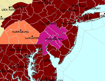
Look at this mess
Red is heat watches, pink is warnings, orange is advisorys
You and I are both "in the pink" - and not in a good way!
I do hope that you guys down in Texas do get precipitation. We've been VERY FORTUNATE that we've been getting precipitation, though some of it has come via severe weather.
0 likes
-
TexasStooge
- Category 5
- Posts: 38127
- Joined: Tue Mar 25, 2003 1:22 pm
- Location: Irving (Dallas County), TX
- Contact:
Here are the current temps at this hour:
DFW Int'l: 87*F
Dallas Love Field: 86*F
Fort Worth Meacham: 86*F
Fort Worth Alliance: 88*F
Denton Municipal Arpt.: 87*F
Gainesville Municipal Airport: 90*F
More Observs here.
DFW Int'l: 87*F
Dallas Love Field: 86*F
Fort Worth Meacham: 86*F
Fort Worth Alliance: 88*F
Denton Municipal Arpt.: 87*F
Gainesville Municipal Airport: 90*F
More Observs here.
0 likes
-
TexasStooge
- Category 5
- Posts: 38127
- Joined: Tue Mar 25, 2003 1:22 pm
- Location: Irving (Dallas County), TX
- Contact:


Return to “USA & Caribbean Weather”
Who is online
Users browsing this forum: AnnularCane and 59 guests