Where will Chris go?
Moderator: S2k Moderators
Forum rules

The posts in this forum are NOT official forecasts and should not be used as such. They are just the opinion of the poster and may or may not be backed by sound meteorological data. They are NOT endorsed by any professional institution or STORM2K. For official information, please refer to products from the National Hurricane Center and National Weather Service.
-
ThunderMate
- Tropical Storm

- Posts: 215
- Joined: Mon Jul 11, 2005 10:18 am
- Location: Virginia Beach, Virginia
- Contact:
-
HouTXmetro

- Category 5

- Posts: 3949
- Joined: Sun Jun 13, 2004 6:00 pm
- Location: District of Columbia, USA
Air Force Met wrote:dwg71 wrote: No, I agree with you, my point was to other poster that said it would be 4 degrees north and be in Houston Area since Gilbert was 4 degrees south of Chris at this point. I agree with synoptic set up and think your on point. I was not being disagreeable. I guess brain did not reach fingertips. Sorry.
N/P
I agree with that...no track is alike. If the ridge on the Euro verifies...this goes towards Corpus. If GFS verifies...its a mid-Texas. If the CMC verifies...its BRO. They could all be wrong and it would be GLS.
Gilbert surfed a ridge wave. Chris will get a ridge handoff. That will alter the bee-line track some. Nobody knows how the ridge pattern will truly set up in 6-7 days. All we do know is the globals agree one will be there...whether it is over LA or GA...and that makes a BIG diff whether this goes into LA or TX...
which right now...IF I was a betting man...I would lay the money down on those two states. Somewhere west of Lake Charles and north of Corpus. I know that is a lot of real estate...but with the pattern seen in the models...well you gotta make a forecast based on something...
and I don't have a time machine.
AFM, which models have been handling High Pressure the best this summer?
0 likes
[Disclaimer: My Amateur Opinion, please defer to your local authorities or the NHC for Guidance.]
-
Air Force Met
- Military Met

- Posts: 4372
- Age: 57
- Joined: Tue Jul 08, 2003 9:30 am
- Location: Roan Mountain, TN
-
KFDM Meteorologist

- Professional-Met

- Posts: 1314
- Joined: Tue May 16, 2006 9:52 pm
- Location: Upper Texas Coast/Orange County


I'm not a pro or barely even an amateur. And I haven't been running water vapor loops (long term) at all this season to watch the upper air patterns. But I have run a few of the global models this season and one major difference is the way the ridges are existing the US Coast W-E. Last year, they were coming off around the Carolinas and hooking up with the existing Bermuda Ridge making it the dominant feature in all of the Atlantic. So far this year, they've come off a little further north and aren't immediately merging with the big high. It's almost like they're bleeding in and the whole thing isn't as strong in the western Atlantic as it is nearer to Europe. Specifically, the GFS had been trying to kill any ridging beyond the 4 day period (and possibly beyond but I haven't been running the 2-3 week models) in the western Atlantic and replacing it with more trofiness than actually has occurred. Then it corrects itself the next day but still tries to kill that ridge. We already know that this is a known weakness with the model in non-El Nino years but for whatever reason, it just can't seem to handle that stuff as well in the medium to long term solutions. One day they'll figure it out and correct it. And guess what? It ain't gonna be me doing those types of calculations  .
.
Steve
Steve
0 likes
-
wxman22

- Category 5
- Posts: 1954
- Joined: Mon Jan 30, 2006 12:39 am
- Location: Wichita Falls, TX
- Contact:
DISCLAIMER:The following post is NOT an official forecast and should not be used as such. It is just the opinion of the poster and may or may not be backed by sound meteorological data. It is NOT endorsed by any professional institution including storm2k.org. For official information, please refer to NHC and NWS products.
Here's my forcast and chances of Chris making a landfall, this will change as we get a better understanding.
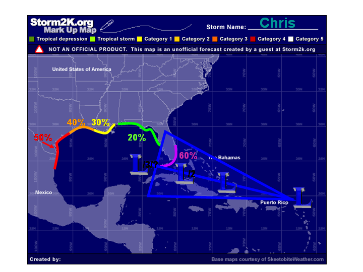
Here's my forcast and chances of Chris making a landfall, this will change as we get a better understanding.
0 likes

-
KFDM Meteorologist
- Professional-Met
- Posts: 1314
- Joined: Tue May 16, 2006 9:52 pm
- Location: Upper Texas Coast/Orange County
-
KFDM Meteorologist
- Professional-Met
- Posts: 1314
- Joined: Tue May 16, 2006 9:52 pm
- Location: Upper Texas Coast/Orange County
-
HouTXmetro
- Category 5
- Posts: 3949
- Joined: Sun Jun 13, 2004 6:00 pm
- Location: District of Columbia, USA
-
KFDM Meteorologist
- Professional-Met
- Posts: 1314
- Joined: Tue May 16, 2006 9:52 pm
- Location: Upper Texas Coast/Orange County
-
HouTXmetro
- Category 5
- Posts: 3949
- Joined: Sun Jun 13, 2004 6:00 pm
- Location: District of Columbia, USA
-
chrisnnavarre
- Category 1

- Posts: 309
- Joined: Fri Oct 03, 2003 5:52 pm
- Contact:
KFDM Meteorologist wrote:If the ridge builds west like i'm seeing even on the GFS yes.
Climatology says no-way it travels that far west. Three factors - #1 climatology, #2 Chris is a strong-storm once in the gulf pushing poleward,
#3 A trough passing on Monday influences Chris to move to the north.
Maybe your right, but I just don't see it. This time of year...Central Mississippi Gulf Coast or NOLA that would be my guess. But what do I know.
0 likes
-
B'hamBlazer
- Tropical Depression

- Posts: 60
- Joined: Mon Jun 12, 2006 9:57 am
- Location: Birmingham, AL
My guess would be north central gulf coast. I do expect it to remain on a WNW path for a while longer, but once in the Gulf I expect it to begin to get more of a northward component. I say between Pensacola and New Orleans as a strong Cat 3.
Last edited by B'hamBlazer on Wed Aug 02, 2006 1:55 pm, edited 1 time in total.
0 likes
-
Grease Monkey

- Category 2

- Posts: 727
- Joined: Fri Jun 09, 2006 9:25 pm
skysummit wrote:hypercane wrote:JB said on his vid today that Chris will move into the central gulf and be a cat4 or cat5 over the loop current and hit somewhere in Texas as a major hurricane!
Can someone else confirm this Cat 4 or 5 statement?
He said this in his noon video. Said it should be weakening as it approaches Texas coast.
0 likes
-
chrisnnavarre
- Category 1
- Posts: 309
- Joined: Fri Oct 03, 2003 5:52 pm
- Contact:
skysummit wrote:hypercane wrote:JB said on his vid today that Chris will move into the central gulf and be a cat4 or cat5 over the loop current and hit somewhere in Texas as a major hurricane!
Can someone else confirm this Cat 4 or 5 statement?
JB has been calling for a Texas or Carolina hit since the season started. So of
course he's saying Texas now. I'll wait for the NHC track on Sunday. That's the safe bet.
0 likes
Who is online
Users browsing this forum: South Texas Storms and 165 guests