Tropical Storm Chris
Moderator: S2k Moderators
-
Stormcenter
- S2K Supporter

- Posts: 6689
- Joined: Wed Sep 03, 2003 11:27 am
- Location: Houston, TX
I don't like it when the NHC is still leaving the door open for regeneration. It makes me just a little concerned.
Last edited by Stormcenter on Fri Aug 04, 2006 10:08 am, edited 1 time in total.
0 likes
- KFDM Meteorologist
- Professional-Met

- Posts: 1314
- Joined: Tue May 16, 2006 9:52 pm
- Location: Upper Texas Coast/Orange County
Not as much if chris were alot stronger.Rieyeuxs wrote:Another question for the pro mets. Since Chris will clear Hispanola in the next few hours and from what I can see, the SE quadrants still has some firing over it, how much do you think the mountains really effected Chris?
Since Cuba doesn't have the same heights, and the center looks to be passing north of it, will Cuba have as much of an effect?
0 likes
- HouTXmetro
- Category 5

- Posts: 3949
- Joined: Sun Jun 13, 2004 6:00 pm
- Location: District of Columbia, USA
Derek Ortt wrote:the more deep convection this has, the more likely it is to hit Cuba as the steering flow in the mid and upper levels is driving it to Cuba, but the low-level flow may allow it to miss
Bingo..... you taught us well Derick
the question in the absence of deep convection will it survive long enough even if it clears Cuba.
0 likes
[Disclaimer: My Amateur Opinion, please defer to your local authorities or the NHC for Guidance.]
- x-y-no
- Category 5

- Posts: 8359
- Age: 65
- Joined: Wed Aug 11, 2004 12:14 pm
- Location: Fort Lauderdale, FL
Stud wrote:From what I understand right now, there's no convection around the circulation, and in order for the storm to restrengthen, there needs to be storms around the circulation.
Yes.
1) Is it likely that the shear Chris is currently facing could tear the circulation up and make it "disappear?"
The shear doesn't directly tear up the circulation, what it does is disrupt the vertical movement of air (convection) in the system. That results in a gradual increase of surface pressure in the center eventually resulting in the opening up of the circulation into a wave.
2) If so, how likely is this?
Pretty likely right now, I'd say. Not a certainty, though. Chris does seem to be a persistent little bugger.
EDIT: On re-reading, I think you were asking how likely is it to "disaappear". My answer was in regards to how likely it is to open up into a wave. I'ts extremely unlikely that it would dissipate completely to the point there isn't even a wave.
3) If not, and the circulation remains open with no convection, and does indeed make it to the gulf and out of the shear in that state, how do the chances look for development, and how likely is this?
Once the wave gets into the gulf, it's likely that the upper air pattern won't be so hostile, so there is a chance it could redevelop.
I've always been fascinated with the weather but don't know a whole hell of a lot about it yet.
Stick around! You're in the right place.
Last edited by x-y-no on Fri Aug 04, 2006 10:13 am, edited 1 time in total.
0 likes
- KFDM Meteorologist
- Professional-Met

- Posts: 1314
- Joined: Tue May 16, 2006 9:52 pm
- Location: Upper Texas Coast/Orange County
CHRIS TOOK A NORTHWESTWARD JOG EARLY THIS MORNING BUT A 12-HOUR
MOTION YIELDS 280/11 KT. CHRIS IS FORECAST TO REMAIN SOUTH OF A
STRONG MID-LEVEL RIDGE FOR THE NEXT 5 DAYS. IN FACT...THE RIDGE IS
FORECAST TO STRENGTHEN OVER THE SOUTHERN UNITED STATES BEYOND DAY 3
WHICH SHOULD KEEP CHRIS ON A GENERAL WEST TO WEST-NORTHWESTWARD
HEADING. THE TRACK GUIDANCE IS IN FAIRLY GOOD AGREEMENT ON THIS
SCENARIO AND THE OFFICIAL FORECAST WAS NUDGED JUST NORTH OF THE
PREVIOUS TRACK. IT LIES JUST NORTH OF THE MODEL CONSENSUS.
0 likes
-
Air Force Met
- Military Met

- Posts: 4372
- Age: 57
- Joined: Tue Jul 08, 2003 9:30 am
- Location: Roan Mountain, TN
x-y-no wrote:mvtrucking wrote:It looks as if the shear has just destroyed it completely.(Amatuer opinion). It is now a open wave and that is the end of it. Next please.
No, there are still very clearly west winds on the south side. This hasn't opened up yet.
You are correct. It hasn't opened up yet. There are west winds. they are getting lighter by the hour...but they are still there.
0 likes
- canetracker
- S2K Supporter

- Posts: 751
- Age: 63
- Joined: Wed Jul 27, 2005 8:49 pm
- Location: Suburbia New Orleans...Harahan, LA
One thing I have learned from watching Chris is that you never know what he is going to do next. It is kind of like watching a soap opera....what will Chris do next? will he go to Cuba, will he fizzle, will he regenerate, where will he go in the GOM???  I prefer to take it day by day, listen to the good forecasting thoughts on the board, and watch the environment.
0 likes
-
jhamps10
AFM,
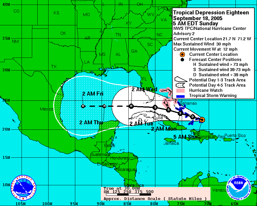
Wow I just looked in the archives of rita, and right now chris is RIGHT where rita was as a depression, and look at the forecasts for rita, and current for chris. Not saying anything more than that, too early to count anyone out, but even more proof for ALL of texas to watch this one closely.
Chris:

Rita:

Wow I just looked in the archives of rita, and right now chris is RIGHT where rita was as a depression, and look at the forecasts for rita, and current for chris. Not saying anything more than that, too early to count anyone out, but even more proof for ALL of texas to watch this one closely.
Chris:

Rita:

0 likes
-
Air Force Met
- Military Met

- Posts: 4372
- Age: 57
- Joined: Tue Jul 08, 2003 9:30 am
- Location: Roan Mountain, TN
Rieyeuxs wrote:Another question for the pro mets. Since Chris will clear Hispanola in the next few hours and from what I can see, the SE quadrants still has some firing over it, how much do you think the mountains really effected Chris?
Since Cuba doesn't have the same heights, and the center looks to be passing north of it, will Cuba have as much of an effect?
The mountains of Hispaniola had a big effect. First, it messed with the southern part of the circulation. Here's a test. Swirl water in a big tub and stick a spoon on the edge of the tub. It still messes with the vortex even though you aren't touching the vortex with your spoon.
Also, Hispaniola cuts off the southerly (moist) inflow into storms. The reason, mountains run SE-NW (gnerally) and when strong winds flow from the south over them...it creates a chinook (to use a US term) on the north side that gets sucked into the circulations of storms). The "chinook" warms the air and dries it out.
0 likes
x-y-no wrote:The shear doesn't directly tear up the circulation, what it does is disrupt the vertical movement of air (convection) in the system. That results in a gradual increase of surface pressure in the center eventually resulting in the opening up of the circulation into a wave.
Pretty likely right now, I'd say. Not a certainty, though. Chris does seem to be a persistent little bugger.
EDIT: On re-reading, I think you were asking how likely is it to "disaappear". My answer was in regards to how likely it is to open up into a wave. I'ts extremely unlikely that it would dissipate completely to the point there isn't even a wave.
Once the wave gets into the gulf, it's likely that the upper air pattern won't be so hostile, so there is a chance it could redevelop.
Stick around! You're in the right place.
Thanks x-y-no. That's what I wanted to know. So even if the shear tears it down to an open wave while it's in the Carribbean, that open wave could move to the Gulf and possibly redevelop?
0 likes
-
jhamps10
- mvtrucking
- S2K Supporter

- Posts: 698
- Age: 67
- Joined: Sat Jul 09, 2005 10:01 am
- Location: Monroe,La
-
Derek Ortt
- KFDM Meteorologist
- Professional-Met

- Posts: 1314
- Joined: Tue May 16, 2006 9:52 pm
- Location: Upper Texas Coast/Orange County
Whole different system, whole different time of the year, Completely different upper air nearChris and over the U.S.jhamps10 wrote:AFM,
Wow I just looked in the archives of rita, and right now chris is RIGHT where rita was as a depression, and look at the forecasts for rita, and current for chris. Not saying anything more than that, too early to count anyone out, but even more proof for ALL of texas to watch this one closely.
Chris:
Rita:
0 likes
-
miamicanes177
- Category 5

- Posts: 1131
- Joined: Tue Aug 01, 2006 10:53 pm
- storms in NC
- S2K Supporter

- Posts: 2338
- Joined: Thu Jul 28, 2005 2:58 pm
- Location: Wallace,NC 40 miles NE of Wilm
- Contact:
- KFDM Meteorologist
- Professional-Met

- Posts: 1314
- Joined: Tue May 16, 2006 9:52 pm
- Location: Upper Texas Coast/Orange County
- DESTRUCTION5
- Category 5

- Posts: 4430
- Age: 44
- Joined: Wed Sep 03, 2003 11:25 am
- Location: Stuart, FL
Who is online
Users browsing this forum: No registered users and 192 guests


