Hurricane Charley Anniversary thread - 8/13/04

This is the general tropical discussion area. Anyone can take their shot at predicting a storms path.

Moderator: S2k Moderators

Forum rules

The posts in this forum are NOT official forecasts and should not be used as such. They are just the opinion of the poster and may or may not be backed by sound meteorological data. They are NOT endorsed by any professional institution or STORM2K. For official information, please refer to products from the National Hurricane Center and National Weather Service.

Help Support Storm2K
Message
Author
User avatar
Extremeweatherguy
Category 5
Category 5
Posts: 11095
Joined: Mon Oct 10, 2005 8:13 pm
Location: Florida

Hurricane Charley Anniversary thread - 8/13/04

#1 Postby Extremeweatherguy » Fri Aug 11, 2006 10:43 pm

Today is the two year Anniversary of one of the strongest storms to ever hit the United States...Hurricane Charley.

Hurricane Charley links:

Wikipedia page on Hurricane Charley: http://en.wikipedia.org/wiki/Hurricane_Charley

USGS Charley impact study: http://coastal.er.usgs.gov/hurricanes/charley/

Videos, pictures and chase account from storm chaser Mike Theiss: http://www.mthurricane.com/Hurricane_Charley.htm

Hurricane Intercept research team Charley page: http://www.vastormphoto.com/charley2004pg2.htm


ALSO, here is a time-line I put together of Charley's passage through Florida (with pictures and video included):

Morning News report about Charley changing course - http://www.youtube.com/watch?v=iehVk_LmUEs


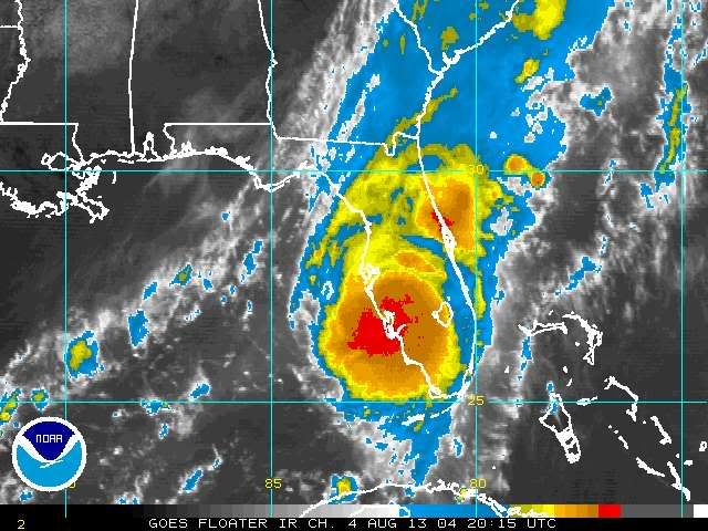
LANDFALL - 3:45pm 8/13/04
At 3:45pm Charley made landfall as a 150mph Category 4 Hurricane in SW Florida. As it came ashore, sustained winds over 125mph and gusts to 175mph were observed. These winds led to major damage in the cities of Port Charlotte and Punta Gorda.

Hurricane Charley beginning to make landfall (video) - http://www.weatherpaparazzi.com/video/videodetail.asp?id=4

Eyewall in Punta Gorda (video) - http://www.weatherpaparazzi.com/video/videodetail.asp?id=5

Wow - http://www.youtube.com/watch?v=LvPdQPnSstY

Backside of the storm in Punta Gorda (video) - http://www.weatherpaparazzi.com/video/videodetail.asp?id=6

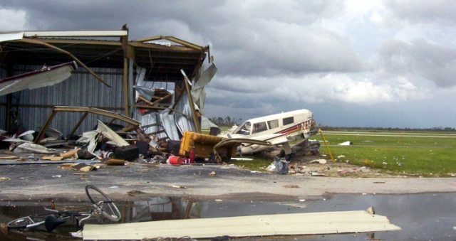
SW Florida damage pictures:
http://www.parrinspections.com/graphics ... _Erwin.jpg
http://www.geocities.com/lschol@sbcglob ... Gorda8.JPG
http://www.polyfoam.cc/images/CharleyMortar-Lg.jpg
http://www.ens-newswire.com/ens/aug2004 ... icane3.jpg
http://www.aopa.org/images/whatsnew/new ... rley_4.jpg

JUST INLAND - 4 to 6pm 8/13/04
After landfall the storm continued to move inland with sustained winds still topping 100mph and gusts well over 125mph. Severe damages were observed in the town Arcadia due to Charley's high winds.

Map of Arcadia - http://www.ourpropertiesonline.com/graphics/Arcadia_map.gif

Damage pictures from Arcadia:
http://soundwaves.usgs.gov/2005/03/watertowerLG.jpg
http://www.floridadisaster.org/eoc/eoc_ ... CN1156.jpg
http://gbgm-umc.org/umcor/04/photos/cha ... atrees.jpg

CHARLEY IN KISSIMMEE - 8:30pm 8/13/04
Hurricane Charley hit Kissimmee with sustained winds over 80-85mph and gusts in excess of 100-110mph. These winds caused widespread damage in the area. However, just NW of Kissimmee, near Disney world, the winds were less intense, probably near 65-75mph sustained with gusts to 85-95mph.

Radar image of Charley over Kissimmee - http://www.srh.noaa.gov/mlb/charley/AWIPS/cr_kissimmee.gif

Damage in the vicinity of Kissimmee:
http://www.srh.noaa.gov/mlb/charley/Osc ... Course.jpg
http://www.cathyandjoe.com/images/hurricane/2trees.jpg
http://www.orlandosentinel.com/media/ph ... 888858.jpg

Damage at Disney world:
http://www.mkt3000.com/pics/hurricanech ... 61_std.jpg
http://www.mkt3000.com/pics/hurricanech ... 64_std.jpg
http://www.mkt3000.com/pics/hurricanech ... 74_std.jpg
http://www.mkt3000.com/pics/hurricanech ... 68_std.jpg
http://www.mkt3000.com/pics/hurricanech ... 85_std.jpg

CHARLEY IN ORLANDO - 9pm 8/13/04
Orlando experienced sustained winds between 75-90mph and gusts to 110mph as Charley blew through. These winds caused widespread damages in the area.

Charley approaching Orlando - http://www.youtube.com/watch?v=pG44PkM34E4

Radar image of Charley over Orlando - http://www.srh.noaa.gov/mlb/charley/AWIPS/cr_orlando.gif

News footage during 105mph gust in Orlando (video) - http://video.yahoo.com/video/play?ei=UTF-8&p=hurricane+charley+orlando&b=1&oid=ad1a4a7dccbfc33c&rurl=www.rogersimmons.com

Brief video I shot during Charley - http://www.youtube.com/watch?v=mWqEhpsnXZ8

Damage pictures from Orange County, FL (including Orlando):
http://www.srh.noaa.gov/mlb/charley/Orange/Orlando2.jpg
http://www.srh.noaa.gov/mlb/charley/Ora ... range2.jpg
http://www.pressure-clean.com/images/hu ... %20076.jpg
http://www.pressure-clean.com/images/0540012.jpg

Personal video of damage following Charley: Image

Another personal damage video: http://www.youtube.com/watch?v=Ao4TRlEtRK0

Quote from the St. Petersberg Times:
The greater Orlando area suffered an estimated $3-billion in damage, and about 1-million people were initially left without power.


HURRICANE CHARLEY IN SANFORD - 10pm 8/13/04
Charley continued to pack a punch even 150+ miles inland. In Sanford, winds over 70-80mph and gusts as high as 100+mph continued to do vast amounts of damage.

Radar image of Charley over Sanford - http://www.srh.noaa.gov/mlb/charley/AWIPS/cr_sanford.gif

Damage in Seminole County, FL (including Sanford):
http://www.srh.noaa.gov/mlb/charley/Sem ... inole2.jpg
http://www.srh.noaa.gov/mlb/charley/Sem ... inole9.jpg
http://www.srh.noaa.gov/mlb/charley/Sem ... inole3.jpg
http://www.srh.noaa.gov/mlb/charley/Sem ... inole6.jpg

HURRICANE CHARLEY IN DAYTONA BEACH - 11pm 8/13/04
Hurricane Charley was finally about to pull off the east coast. However, the storm still had a few tricks up it's sleeve. In Daytona Beach (over 200 miles NE of the initial landfall), sustained winds over 65-75mph and gusts to 90-100mph caused widespread damage.

Radar image of Charley over Daytona Beach - http://www.srh.noaa.gov/mlb/charley/AWIPS/cr_daytona.gif

Video from Daytona - http://www.youtube.com/watch?v=rQLVEXpCbYM

Damage in Volusia county, FL (including Daytona Beach):
http://www.srh.noaa.gov/mlb/charley/Vol ... lusia8.jpg
http://www.srh.noaa.gov/mlb/charley/Vol ... lusia7.jpg
http://www.orlandosentinel.com/media/ph ... 824011.jpg


Please feel free to add additional information, pictures, stories, videos, links, etc. to this thread.


updated: 8/13/07
Last edited by Extremeweatherguy on Mon Aug 13, 2007 12:27 pm, edited 10 times in total.
0 likes   

User avatar
Swimdude
Category 5
Category 5
Posts: 2270
Joined: Mon Jul 26, 2004 11:57 am
Location: Houston, TX

#2 Postby Swimdude » Fri Aug 11, 2006 11:25 pm

Very good research. I enjoyed several of the sites. This is what this board is all about!
0 likes   

User avatar
mike815
Category 5
Category 5
Posts: 1460
Joined: Fri Jul 22, 2005 8:21 am
Location: palm bay fl

#3 Postby mike815 » Fri Aug 11, 2006 11:31 pm

thanks man what a storm some incredible memories was basicly my first storm i tracked thanks again for this post
0 likes   

User avatar
Cyclenall
Category 5
Category 5
Posts: 6667
Joined: Thu Jun 08, 2006 10:01 pm
Location: Ontario, Canada

#4 Postby Cyclenall » Fri Aug 11, 2006 11:32 pm

Very good post with a good time line with pictures to see how much damage went well inland.

Link: http://www.water.net/Charley/

Just click that link to know a large amount of information about Hurricane Charley. There are videos and a amazing time line with a news station.
0 likes   

User avatar
Extremeweatherguy
Category 5
Category 5
Posts: 11095
Joined: Mon Oct 10, 2005 8:13 pm
Location: Florida

#5 Postby Extremeweatherguy » Fri Aug 11, 2006 11:36 pm

Cyclenall wrote:Very good post with a good time line with pictures to see how much damage went well inland.

Link: http://www.water.net/Charley/

Just click that link to know a large amount of information about Hurricane Charley. There are videos and a amazing time line with a news station.
That is a very informative website. Thanks for posting it!
0 likes   

Josephine96

#6 Postby Josephine96 » Fri Aug 11, 2006 11:56 pm

GUSTS were 100-110 :lol:

They sure sounded sustained..

Charley was the 1 storm that scared the bajeezers out of me.. Hearing things flying off the house., crashing into the house, a 25-30 ft tree across the street coming crashing down, widespread damage city wide

and most importantly.. no power for 11 DAYS! i got used to bread and cereal :lol: and actually got used to and looked forward to cold showers
0 likes   

User avatar
Extremeweatherguy
Category 5
Category 5
Posts: 11095
Joined: Mon Oct 10, 2005 8:13 pm
Location: Florida

#7 Postby Extremeweatherguy » Sat Aug 12, 2006 12:07 am

Josephine96 wrote:GUSTS were 100-110 :lol:

They sure sounded sustained..

Charley was the 1 storm that scared the bajeezers out of me.. Hearing things flying off the house., crashing into the house, a 25-30 ft tree across the street coming crashing down, widespread damage city wide

and most importantly.. no power for 11 DAYS! i got used to bread and cereal :lol: and actually got used to and looked forward to cold showers
I am just going off of official information and post storm analysis' for Charley. I know what you mean though. Up in Orlando, the winds seemed worse too (and also scared me), but in reality the whole corridor from Kissimmee to Orlando to Sanford only saw top gusts near 100-110mph (with a few places seeing higher gusts up to 115-120mph in isolated microbursts). As we all saw after the storm though...these type of winds do horrible damage.
0 likes   

f5
Category 5
Category 5
Posts: 1550
Joined: Thu Aug 25, 2005 3:29 pm
Location: Waco,tx

#8 Postby f5 » Sat Aug 12, 2006 1:32 am

can wait to see the posts about Charley being upgraded to a CAT 5
0 likes   

HomesteadHoney
Tropical Low
Tropical Low
Posts: 25
Joined: Mon Sep 19, 2005 5:06 pm
Location: Homestead, FL

#9 Postby HomesteadHoney » Sat Aug 12, 2006 6:49 am

Memories of Charley.....
My mother-in-law lived in Port Charlotte but she was away in North Carolina at the time of the storm. After the storm hit, my husband and I loaded our truck with supplies, everything from roof felt to plywood to a generator plus bottled water and food. Having been through Andrew, we knew what we would probably find over there.
Our goal was to secure my mother-in-laws house, remove anything wet that would get moldy or go bad and help out the elderly neighbors who were still in town. We wanted her house to be as secure as possible with no further damage occuring so she could stay in NC until power and water were restored.
The house looked pretty good from the front with just a few windows out and the door blown open. It was surrounded on both sides by tall dense scrub trees which helped reduce the winds. It also looked pretty good from the back with just the patio roof blown away.
When we went into the house, we were shocked to find the top half of a huge pinetree in the dining room. It had snapped off and fallen straight into the house like an arrow! Waving cash at the tree cutter guys roaming the neighborhood, we were able to have them cut it out so we could "dry in" the gaping hole in the roof. We spent Saturday securing windows, cleaning the fridge out and pulling out wet carpets.
We gave the Generator to the neighbors (at cost of course) as well as our extra supplies and headed home. The town was never the same. Real estate prices sky-rocketed and she sold and moved up to St. Pete the next year.
Here's some advice, when a storm approaches and you are in the cone, take your before photos. After the damage, take your after shots and any else you need to file a claim. Don't wait to secure your house from further damage, the insurance company does not need to see it before it's cleaned up.
0 likes   

User avatar
tailgater
S2K Supporter
S2K Supporter
Posts: 3339
Joined: Sun Jul 11, 2004 9:13 pm
Location: St. Amant La.

#10 Postby tailgater » Sat Aug 12, 2006 7:17 am

Very good post( advice ) HH, isn't it amazing the difference between a storm maintaining or losing intensity and one gaining strength, ie; the damage father inland
0 likes   

User avatar
Normandy
Category 5
Category 5
Posts: 2293
Joined: Sun Oct 10, 2004 12:31 am
Location: Houston, TX

#11 Postby Normandy » Sat Aug 12, 2006 9:36 am

Nice post....I always look at Charley as a smaller re-incarnation of Andrew....incredibly intense storm.
0 likes   

User avatar
Extremeweatherguy
Category 5
Category 5
Posts: 11095
Joined: Mon Oct 10, 2005 8:13 pm
Location: Florida

#12 Postby Extremeweatherguy » Sat Aug 12, 2006 10:43 am

I just updated to add a "Damage at Disney world" section of pictures. These give you a good idea of the difference in windspeed between the themepark and areas just east.
0 likes   

JonathanBelles
Professional-Met
Professional-Met
Posts: 11430
Age: 35
Joined: Sat Dec 24, 2005 9:00 pm
Location: School: Florida State University (Tallahassee, FL) Home: St. Petersburg, Florida
Contact:

#13 Postby JonathanBelles » Sat Aug 12, 2006 11:25 am

yes, charley came very close to make landfall here on friday the 13th of all days. ive been to both port charlote and punta gorda since and damage is still visible as are the ugly white fema trailers. you can tell where beach erosion was as they are slowly rebuilding the beaches. i am planning a trip to visit 4 hurricane bad spots in september: punta gorda, everglades city, coastal miami, and jupiter/fort pierce.
0 likes   

User avatar
vacanechaser
Category 5
Category 5
Posts: 1461
Joined: Wed Dec 03, 2003 9:34 pm
Location: Portsmouth, Va
Contact:

#14 Postby vacanechaser » Sat Aug 12, 2006 11:34 am

Ok.. i am a little upset with you people.... all this talk of charley, and no photos and video link from ME!!!!! what is the problem here!!! :cheesy: :ggreen: lol...

anyway, here is the link to page one which contains the photos to bonnie the day before... http://www.vastormphoto.com/charley2004pg1.htm

here is the link to page two which is the charley stuff....
http://www.vastormphoto.com/charley2004pg2.htm


also here the two links to the two video i have online for charley...

http://www.vastormphoto.com/MyVideos/charley1web.wmv
http://www.vastormphoto.com/MyVideos/charley2web.wmv


Jesse V. Bass III
http://www.vastormphoto.com
Hurricane Intercept Research Team
0 likes   
Jesse V. Bass III
http://www.vastormphoto.com
Hurricane Intercept Research Team

quandary
Category 1
Category 1
Posts: 362
Joined: Thu Sep 16, 2004 4:04 pm

#15 Postby quandary » Sat Aug 12, 2006 11:40 am

f5 wrote:can wait to see the posts about Charley being upgraded to a CAT 5


Well, in fairness, of all the storms, this one was really really close. Winds of 150 and 155 mph very near landfall, so its only a stone's throw away from Cat 5.
0 likes   

User avatar
Extremeweatherguy
Category 5
Category 5
Posts: 11095
Joined: Mon Oct 10, 2005 8:13 pm
Location: Florida

#16 Postby Extremeweatherguy » Sat Aug 12, 2006 11:41 am

vacanechaser wrote:Ok.. i am a little upset with you people.... all this talk of charley, and no photos and video link from ME!!!!! what is the problem here!!! :cheesy: :ggreen: lol...

anyway, here is the link to page one which contains the photos to bonnie the day before... http://www.vastormphoto.com/charley2004pg1.htm

here is the link to page two which is the charley stuff....
http://www.vastormphoto.com/charley2004pg2.htm


also here the two links to the two video i have online for charley...

http://www.vastormphoto.com/MyVideos/charley1web.wmv
http://www.vastormphoto.com/MyVideos/charley2web.wmv


Jesse V. Bass III
http://www.vastormphoto.com
Hurricane Intercept Research Team


Thanks for adding those. They add even more great information to this page! Sorry for not posting them in the first place. :cheesy:
0 likes   

User avatar
vacanechaser
Category 5
Category 5
Posts: 1461
Joined: Wed Dec 03, 2003 9:34 pm
Location: Portsmouth, Va
Contact:

#17 Postby vacanechaser » Sat Aug 12, 2006 11:43 am

Extremeweatherguy wrote:
vacanechaser wrote:Ok.. i am a little upset with you people.... all this talk of charley, and no photos and video link from ME!!!!! what is the problem here!!! :cheesy: :ggreen: lol...

anyway, here is the link to page one which contains the photos to bonnie the day before... http://www.vastormphoto.com/charley2004pg1.htm

here is the link to page two which is the charley stuff....
http://www.vastormphoto.com/charley2004pg2.htm


also here the two links to the two video i have online for charley...

http://www.vastormphoto.com/MyVideos/charley1web.wmv
http://www.vastormphoto.com/MyVideos/charley2web.wmv


Jesse V. Bass III
http://www.vastormphoto.com
Hurricane Intercept Research Team


Thanks for adding those. They add even more great information to this page! Sorry for not posting them in the first place. :cheesy:


lol... i was just kidding... lol... at least you can see in my video that we went through the center of the eye... not just outside.... we were in the dead calm....


Jesse V. Bass III
http://www.vastormphoto.com
Hurricane Intercept Research Team
0 likes   
Jesse V. Bass III
http://www.vastormphoto.com
Hurricane Intercept Research Team

Jim Cantore

#18 Postby Jim Cantore » Sat Aug 12, 2006 12:13 pm

Image

Image

ZCZC MIATCPAT3 ALL
TTAA00 KNHC DDHHMM CCA
BULLETIN
HURRICANE CHARLEY SPECIAL ADVISORY NUMBER 18 CORRECTION
NWS TPC/NATIONAL HURRICANE CENTER MIAMI FL
2 PM EDT FRI AUG 13 2004

CORRECTION...THE TROPICAL STORM WARNING FOR SOUTHEAST FLORIDA FROM
OCEAN REEF TO JUPITER INLET SHOULD BE A TROPICAL STORM WATCH.

...CHARLEY STRENGTHENS TO CATEGORY FOUR HURRICANE AND HEADS FOR
SOUTHWEST FLORIDA COAST...

A HURRICANE WARNING REMAINS IN EFFECT FOR THE FLORIDA KEYS FROM THE
DRY TORTUGAS TO THE SEVEN MILE BRIDGE...AND FOR THE FLORIDA WEST
COAST FROM EAST CAPE SABLE NORTHWARD TO THE STEINHATCHEE RIVER.

AT 2 PM EDT...1800Z...A HURRICANE WARNING IS ISSUED FOR THE
SOUTHEAST U.S. COAST FROM COCOA BEACH FLORIDA NORTHWARD TO THE
SOUTH SANTEE RIVER SOUTH CAROLINA. A TROPICAL STORM WARNING AND A
HURRICANE WATCH ARE ALSO ISSUED FROM NORTH OF THE SOUTH SANTEE
RIVER TO CAPE LOOKOUT NORTH CAROLINA.

A TROPICAL STORM WARNING REMAINS IN EFFECT FOR THE FLORIDA KEYS FROM
THE SEVEN MILE BRIDGE TO OCEAN REEF...INCLUDING LAKE OKEECHOBEE AND
FLORIDA BAY. A TROPICAL STORM WATCH REMAINS IN EFFECT FROM CAPE
LOOKOUT TO OREGON INLET NORTH CAROLINA INCLUDING PAMLICO SOUND AND
ALONG THE SOUTH FLORIDA MAINLAND FROM OCEAN REEF TO SOUTH OF COCOA
BEACH FLORIDA.

AT 2 PM EDT...1800Z...THE CENTER OF HURRICANE CHARLEY WAS LOCATED
NEAR LATITUDE 26.0 NORTH...LONGITUDE 82.4 WEST OR ABOUT 60 MILES
SOUTHWEST OF FT. MYERS FLORIDA.

CHARLEY IS MOVING TOWARD THE NORTH-NORTHEAST NEAR 20 MPH. ON THIS
TRACK...THE CENTER OF CHARLEY SHOULD MAKE LANDFALL IN THE VICINITY
OF CHARLOTTE HARBOR FLORIDA LATER THIS AFTERNOON.

MAXIMUM SUSTAINED WINDS HAVE INCREASED TO NEAR 145 MPH WITH HIGHER
GUSTS. THE STRONGEST WINDS ARE CONCENTRATED IN A VERY SMALL AREA
NEAR THE CENTER OF THE HURRICANE. SOME FLUCTUATIONS IN WIND SPEED
MAY OCCUR BEFORE LANDFALL.

HURRICANE FORCE WINDS EXTEND OUTWARD UP TO 30 MILES... 45 KM...
FROM THE CENTER...AND TROPICAL STORM FORCE WINDS EXTEND OUTWARD UP
TO 105 MILES...165 KM.

ESTIMATED MINIMUM CENTRAL PRESSURE IS 954 MB...28.17 INCHES.

STORM SURGE FLOODING IN THE FLORIDA KEYS WILL BE SUBSIDING LATER
TODAY. STORM SURGE FLOODING OF 10 TO 15 FEET IS EXPECTED NEAR AND
SOUTH OF THE WHERE THE CENTER CROSSES THE FLORIDA WEST COAST.
STORM SURGE FLOODING OF 4 TO 7 FEET ALONG AND NEAR THE NORTHEAST
FLORIDA AND GEORGIA COASTS IS EXPECTED IN THE NEXT 24 HOURS WITH
LESSER FLOODING TO THE NORTH AND SOUTH.

RAINFALL TOTALS OF 4 TO 8 INCHES ARE LIKELY ALONG CHARLEYS PATH
ACROSS PORTIONS OF THE EASTERN UNITED STATES. THESE RAINS COULD
CAUSE LIFE-THREATENING FLASH FLOODS.

ISOLATED TORNADOES ARE POSSIBLE ACROSS PARTS OF SOUTHERN AND CENTRAL
FLORIDA INCLUDING THE FLORIDA KEYS TODAY.

REPEATING THE 2 PM EDT POSITION...26.0 N... 82.4 W. MOVEMENT
TOWARD...NORTH-NORTHEAST NEAR 20 MPH. MAXIMUM SUSTAINED
WINDS...145 MPH. MINIMUM CENTRAL PRESSURE... 954 MB.

FOR STORM INFORMATION SPECIFIC TO YOUR AREA...PLEASE MONITOR
PRODUCTS ISSUED BY YOUR LOCAL WEATHER OFFICE.

THE NEXT ADVISORY WILL BE ISSUED BY THE NATIONAL HURRICANE CENTER AT
5 PM EDT.

FORECASTER LAWRENCE
0 likes   

User avatar
Normandy
Category 5
Category 5
Posts: 2293
Joined: Sun Oct 10, 2004 12:31 am
Location: Houston, TX

#19 Postby Normandy » Sat Aug 12, 2006 4:20 pm

Charley was defitely about to go through an ERC....too bad it was too soon for Port Charlotte/Punta Gorda.
0 likes   

Sanibel
Category 5
Category 5
Posts: 10375
Joined: Mon Aug 30, 2004 11:06 pm
Location: Offshore SW Florida

#20 Postby Sanibel » Sat Aug 12, 2006 5:00 pm

Tore our porch screen cage off mericilessly like a giant hand wiping it all away in one swoop.
0 likes   


Return to “Talkin' Tropics”

Who is online

Users browsing this forum: Extratropical94, Google [Bot] and 23 guests