Hurricane Charley Anniversary thread - 8/13/04

This is the general tropical discussion area. Anyone can take their shot at predicting a storms path.

Moderator: S2k Moderators

Forum rules

The posts in this forum are NOT official forecasts and should not be used as such. They are just the opinion of the poster and may or may not be backed by sound meteorological data. They are NOT endorsed by any professional institution or STORM2K. For official information, please refer to products from the National Hurricane Center and National Weather Service.

Help Support Storm2K
Message
Author
User avatar
The_OD_42
Tropical Depression
Tropical Depression
Posts: 61
Joined: Fri Jun 09, 2006 11:35 pm
Location: Odessa, FL (Tampa)

#41 Postby The_OD_42 » Sun Aug 13, 2006 8:32 am

MGC wrote:I'll trade ya'll Charley for Katrina...any takers. I was driving to the supermarket when I heard the upgrade to Cat-4. I had just left home an hour earlier and as I recall Charley was like a low end Cat-3. I about dropped my coffee when I heard the radio announcer say the winds were 145mph. Talk about a bad situation, a hurricane bombing just before landfall.....MGC


Yeh but imagine them telling you that Katrina was going to hit Texas or Alabama instead of Louisiana..that is, until 2 hours or so before it actually makes landfall, it decides to turn your direction. Sure Charley could've been worse, ANY hurricane could be worse than it was, but I would take a 175 mph hurricane heading sraight for me and have the time to prepare and "hunker down" than to be rudely awakened and surprised like the people of SW Florida were on that Friday. Because, as far as I can remember SW Florida (Punta Gorda/ Port Charlotte/ Ft. Myers/ Naples) only had Hurricane watches...I BELIEVE. I don't think thy had any evacuations put into place. But if I am wrong, please correct me. (I was too busy looking at how Charley was forecasted to move through Tampa Bay right over my house) From all of the people who I know who were in SW Florida that day, they were not prepared. Many had shutters, but they were the electric shutters and electricity had already gone out by the time they knew Charley was turning. Some didnt even know he was turning becuase they didnt have electricity to watch TV. Anyway, one thing is for sure, like I said, I'd rather be battered by a cat 5 monster than to be surprised and unprepared for even a cat 1.
0 likes   

Sanibel
Category 5
Category 5
Posts: 10375
Joined: Mon Aug 30, 2004 11:06 pm
Location: Offshore SW Florida

#42 Postby Sanibel » Sun Aug 13, 2006 8:39 am

I was in Miami watching Charley on TV and internet. I told my relative that storm was for certain going to turn towards Sanibel. He laughed at me saying the weather experts say it's going to Tampa. 3 hours later Charley was turning and heading right for Sanibel. When I heard the special report of intensification to category 4 145mph I went outside and took a walk wringing my hands and telling people in the Miami street that my house was being destroyed by another hurricane Andrew as we spoke. After being unable to get any information over the phone from the area my relative had the bright idea of calling the house number. The phone rang. That was a big relief because we both knew that if the phone was ringing it was connected and the wall was still there. (I had images of a wall hanging in mid-air on stilts with a phone connected to it and the rest of the house blown away)

I drove back immediately only to spend the next 5 days in a crowded ice hockey arena awaiting permission to get back on the island. During that time we saw news footage showing most of the houses intact. I wish I had ridden it out because this was the ultimate riding storm as far as experience and impact. But to do so would have risked being a Katrina-like victim.

Charley was headed right for Bowman's beach 5 miles north of us when it wobbled out around the island and then turned right over North Captiva cutting it in half.
0 likes   

User avatar
The_OD_42
Tropical Depression
Tropical Depression
Posts: 61
Joined: Fri Jun 09, 2006 11:35 pm
Location: Odessa, FL (Tampa)

#43 Postby The_OD_42 » Sun Aug 13, 2006 8:52 am

Sanibel wrote:I was in Miami watching Charley on TV and internet. I told my relative that storm was for certain going to turn towards Sanibel. He laughed at me saying the weather experts say it's going to Tampa. 3 hours later Charley was turning and heading right for Sanibel. When I heard the special report of intensification to category 4 145mph I went outside and took a walk wringing my hands and telling people in the Miami street that my house was being destroyed by another hurricane Andrew as we spoke. After being unable to get any information over the phone from the area my relative had the bright idea of calling the house number. The phone rang. That was a big relief because we both knew that if the phone was ringing it was connected and the wall was still there. (I had images of a wall hanging in mid-air on stilts with a phone connected to it and the rest of the house blown away)

I drove back immediately only to spend the next 5 days in a crowded ice hockey arena awaiting permission to get back on the island. During that time we saw news footage showing most of the houses intact. I wish I had ridden it out because this was the ultimate riding storm as far as experience and impact. But to do so would have risked being a Katrina-like victim.

Charley was headed right for Bowman's beach 5 miles north of us when it wobbled out around the island and then turned right over North Captiva cutting it in half.


I used to vacation in Captiva and I have to say that Sanibel and Captiva re very beautiful islands. When youre on Captiva, its almost like youre in another country, down in the tropics somewhere. I was really sad to see the devastation there, especially North Captiva.
0 likes   

User avatar
TampaFl
S2K Supporter
S2K Supporter
Posts: 1904
Age: 67
Joined: Thu Sep 04, 2003 11:23 am
Location: Tampa, FL

#44 Postby TampaFl » Sun Aug 13, 2006 8:56 am

The_OD_42 wrote:
MGC wrote:I'll trade ya'll Charley for Katrina...any takers. I was driving to the supermarket when I heard the upgrade to Cat-4. I had just left home an hour earlier and as I recall Charley was like a low end Cat-3. I about dropped my coffee when I heard the radio announcer say the winds were 145mph. Talk about a bad situation, a hurricane bombing just before landfall.....MGC


Yeh but imagine them telling you that Katrina was going to hit Texas or Alabama instead of Louisiana..that is, until 2 hours or so before it actually makes landfall, it decides to turn your direction. Sure Charley could've been worse, ANY hurricane could be worse than it was, but I would take a 175 mph hurricane heading sraight for me and have the time to prepare and "hunker down" than to be rudely awakened and surprised like the people of SW Florida were on that Friday. Because, as far as I can remember SW Florida (Punta Gorda/ Port Charlotte/ Ft. Myers/ Naples) only had Hurricane watches...I BELIEVE. I don't think thy had any evacuations put into place. But if I am wrong, please correct me. (I was too busy looking at how Charley was forecasted to move through Tampa Bay right over my house) From all of the people who I know who were in SW Florida that day, they were not prepared. Many had shutters, but they were the electric shutters and electricity had already gone out by the time they knew Charley was turning. Some didnt even know he was turning becuase they didnt have electricity to watch TV. Anyway, one thing is for sure, like I said, I'd rather be battered by a cat 5 monster than to be surprised and unprepared for even a cat 1.


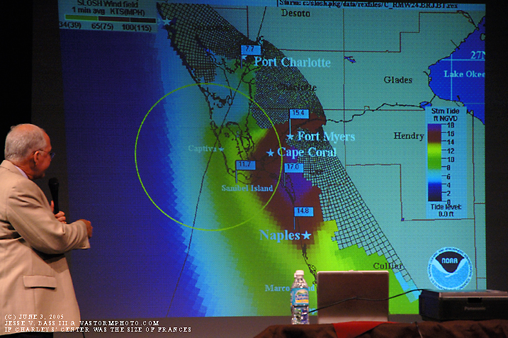
The-OD-42, SW FL was under a hurricane warning which was issued on Thursday Aug 12, @ 05:00am. At 05:00pm they were extended north to include the TAmpa Bay area.the people of SW FL had ample time to prepare, but unfortunatley, I think they focused on the "Skinny Black Line" seeing it heading for Tampa Bay. Below is a time line of watches/warnings issued by the NHC.


Table 7: Table 7. Watch and warning summary for Hurricane Charley, 9-14 August 2004. Date/Time Action Location
10/1500 Tropical Storm Watch Issued Jamaica
10/2100 Tropical Storm Watch Issued Cayman Islands
10/2100 Tropical Storm Watch changed to Tropical Storm Warning Jamaica
10/2100 Tropical Storm Warning issued Southwest Peninsula of Haiti from the Dominican Republic border westward including Port-au-Prince
11/0300 Hurricane Watch Issued Jamaica
11/0300 Tropical Storm Watch changed to Tropical Storm Warning and Hurricane Watch Cayman Islands
11/0900 Hurricane Watch Issued Florida Keys from the Dry Tortugas to Craig Key
11/0900 Tropical Storm Warning and Hurricane Watch changed to Hurricane Warning Cayman Islands
11/1500 Tropical Storm Warning Discontinued Southwest Peninsula of Haiti from the Dominican Republic border westward including Port-au-Prince
11/1500 Hurricane Watch Issued Cuban provinces of Pinar Del Rio, La Habana, Ciudad de la Habana, Matanzas, and the Isle of Youth
11/2100 Tropical Storm Warning and Hurricane Watch changed to Hurricane Warning Jamaica
11/2100 Hurricane Watch Issued East of Craig Key to Ocean Reef including Florida Bay and SW Florida from Flamingo to Bonita Beach
12/0300 Hurricane Watch Issued North of Bonita Beach Florida to Anna Maria Island
12/0900 Hurricane Watch changed to Hurricane Warning Florida Keys from the Dry Tortugas to the Seven Mile Bridge and SW Florida from E Cape Sable to Bonita Beach
12/0900 Tropical Storm Warning Issued Florida Keys from Seven Mile Bridge to Ocean Reef including Florida Bay nd on the mainland west of Ocean Reef to E Cape Sable
12/0900 Hurricane Watch Issued N of Bonita Beach to Tarpon Springs
12/1500 Hurricane Watch Issued N of Tarpon Springs to Suwannee River Florida
12/1500 Hurricane Watch changed to Hurricane Warning Cuban provinces of Pinar Del Rio, La Habana, Ciudad de la Habana, Matanzas, and the Isle of Youth
12/1500 Hurricane Warning Discontinued Jamaica
12/2100 Hurricane Watch changed to Hurricane Warning N of Bonita Beach FL to Bayport
12/2100 Tropical Storm Watch Issued Jupiter Inlet FL north to Altamaha Sound Georgia including Lake Okeechobee
12/2100 Hurricane Warning Discontinued Cayman Islands
13/0300 Hurricane Watch changed to Hurricane Warning N of Bayport to the Suwannee River
13/0300 Tropical Storm Watch changed to Tropical Storm Warning Lake Okeechobee
13/0300 Tropical Storm Watch Issued S of Jupiter Inlet FL to Ocean Reef and N of Altamaha Sound to South Santee River South Carolina
13/0900 Hurricane Warning Issued N of the Suwanne River to the Steinhatchee River FL
13/0900 Tropical Storm Watch changed to Tropical Storm Warning Cocoa Beach FL to Altamaha Sound Georgia
13/0900 Tropical Storm Watch Issued N of South Santee River SC to Cape Fear North Carolina
13/1100 Hurricane Warning Discontinued Cuban provinces of Pinar Del Rio, La Habana, Ciudad de la Habana, Matanzas, and the Isle of Youth
13/1500 Tropical Storm Watch Issued North of Cape Fear NC to Oregon Inlet NC including Pamlico Sound
13/1500 Hurricane Watch Issued Flagler Beach FL northward to the Savannah River near the GA/SC border
13/1500 Tropical Storm Watch changed to Tropical Storm Warning S of Cocoa Beach FL to Jupiter Inlet FL
13/1800 Tropical Storm Warning changed to Hurricane Warning Cocoa Beach FL to Altamaha Sound GA
13/1800 Tropical Storm Watch changed to Hurricane Warning N of Altamaha Sound GA to South Santee River SC
13/1800 Tropical Storm Watch changed to Tropical Storm Warning and Hurricane Watch N of South Santee River SC to Cape Lookout North Carolina
13/2100 Watches/Warnings Discontinued S of Jupiter Inlet along the Florida E coast to Ocean Reef and for all of the FL Keys
13/2100 Tropical Storm Warning and Hurricane Watch changed to Hurricane Warning N of South Santee River SC to Cape Lookout North Carolina
13/2100 Tropical Storm Watch Issued N of Oregon Inlet NC to Chincoteague Virgina including Albemarle Sound and for Lower Chesapeake Bay South of Smith Point
14/0100 Watches/Warnings Discontinued All of the Florida West Coast
14/0300 Tropical Storm Warning Discontinued Lake Okeechobee, FL
14/0300 Tropical Storm Watch changed to Hurricane Warning N of Cape Lookout NC to Oregon Inlet including Pamlico and Albemarle Sounds
14/0300 Tropical Storm Watch changed to Tropical Storm Warning N of Oregon Inlet NC to Chincoteague VA including Lower Chesapeake Bay South of Smith Point
14/0600 Tropical Storm Warning Discontinued S of Cocoa Beach FL to Jupiter Inlet FL
14/0900 Tropical Storm Watch changed to Hurricane Warning N of Oregon Inlet NC to the N Carolina/Virginia state border
14/0900 Tropical Storm Warning Issued N of Chincoteague Virginia to Sandy Hook New Jersey including Upper Chesapeake Bay, the Tidal Potomac and Delaware Bay
14/0900 Tropical Storm Watch Issued N of Sandy Hook NJ to the Merrimack River Massachusetts including New York Harbor and Long Island Sound
14/0900 Hurricane Warning Discontinued Altamaha Sound GA south to Cocoa Beach FL
14/1500 Hurricane Warning Discontinued South of the South Santee River SC to Altamaha Sound GA
14/1500 Tropical Storm Watch changed to Tropical Storm Warning N of Sandy Hook NJ to the Merrimack River MA including New York Harbor and Long Island Sound
14/1800 Hurricane Warning changed to Tropical Storm Warning Little River Inlet South Carolina to the NC/VA border
14/1800 Hurricane Warning Discontinued S of Little River Inlet SC to South Santee River SC
14/2100 Tropical Storm Warning Discontinued S of Cape Lookout NC to Little River Inlet SC
15/0000 Tropical Storm Warning Discontinued S of Oregon Inlet NC to Cape Lookout NC including Pamlico Sound and for Chesapeake Bay N of Smith Point including the Tidal Potomac
15/0300 Tropical Storm Warning Discontinued W of New Haven Connecticut to Oregon Inlet NC and Long Island W of Fire Island
15/1230 Tropical Storm Warning Discontinued W of Watch Hill Rhode Island and for Long Island
15/1500 All Warnings Discontinued
0 likes   

User avatar
The_OD_42
Tropical Depression
Tropical Depression
Posts: 61
Joined: Fri Jun 09, 2006 11:35 pm
Location: Odessa, FL (Tampa)

#45 Postby The_OD_42 » Sun Aug 13, 2006 9:01 am

TampaFL,

Oh okay I'm sorry for the wrong info. Thanks for correcting me 8-)

As far as the not being prepared, I was just taking that from various friends I have down there. And you're right, they focused on the black line, which is why i guess they had not prepared and put up their shutters and what-not. I guess I should look at the NHC before citing what my friends said. :lol:
0 likes   

recmod
Tropical Storm
Tropical Storm
Posts: 214
Joined: Sat Aug 28, 2004 8:57 pm
Location: Orlando, FL
Contact:

#46 Postby recmod » Sun Aug 13, 2006 10:07 am

In my opinion, this thread is being hijacked by one poster's irresponsible and inflammatory remarks. I too was prompted to reply to Shrimper's callous comments....but why bother? That is what he wants. He has gotten all the fame and glory for the past 2 pages of this thread, with the original intent of commemorating the anniversary of Charley gone out the window.

You can never compare one hurricane to another. Each are unique in regards to strength, wind distribution and size of wind field, storm surge effects, population densities in the areas impacted, etc , etc. All these factors affect the ultimate impact that a storm will have on the region struck.

The fact is, Charley was an intense category 4 hurricane that DID impact large population centers. The result: the hurricane was the 4th costliest storm in US history. These are facts. Do not let your temper get the best of you and reply to baited remarks that you know are false, such as "Charley was not a devastating hurricane".

Now, let's get back to the original topic, since today is AUGUST 13, the 2 year anniversary of one of the worst hurricanes ever to strike the United States.

--Lou
0 likes   

bob rulz
Category 5
Category 5
Posts: 1704
Age: 35
Joined: Sat Jan 28, 2006 7:30 pm
Location: Salt Lake City, Utah

#47 Postby bob rulz » Sun Aug 13, 2006 10:09 am

This was the hurricane that really got me interested in tracking hurricanes.
0 likes   

ladygatorslayer
Tropical Low
Tropical Low
Posts: 43
Joined: Fri Sep 10, 2004 4:29 pm
Location: Tampa Bay Area

#48 Postby ladygatorslayer » Sun Aug 13, 2006 10:31 am

At the time of Charlie, I had been living in Pasco County for 24 years and was never fearful of a hurricane. They just didn't happen over on this coast and I never worried about them. ( was a kid during Elena and don't really remember much, the No-Name storm, well, I slept through that)

As the storm approached and evacuations orders were being issued, I was scared out of my mind. I had, for the first time in my life, went to the store to buy supplies. But had to beg my Husband to leave. I didn't want to stay and he was thinking it was no big deal.

Making matters more nerve wracking was that my FIL was suppose to get married on Charlie the 13th. Instead, the whole dang family ended up evacuating to his house and the wedding was postponed.

After all the fuss and worry, it barely sprinkled up here, we were spared as Charlie had other plans. But I don't regret that we left and I will do it again.

Hurricane Charlie taught me to be prepared. It was a learning experience that as a Floridian, I really needed.
0 likes   

User avatar
Extremeweatherguy
Category 5
Category 5
Posts: 11095
Joined: Mon Oct 10, 2005 8:13 pm
Location: Florida

#49 Postby Extremeweatherguy » Sun Aug 13, 2006 10:56 am

I can still remember at about 11am, exactly 2 years ago, I was watching the weather channel predict 30-50mph winds in Orlando. For some reason though, I knew they were wrong. The next thing I know Tom Terry is on the TV with his predictions of 90mph+ winds. Everything had changed so fast, within 10 hours I was now expecting to see Orlando's worst storm in 44 years! I will never forget that moment when he correctly changed the predicted path before the NHC and probably ended up getting a lot of Central Floridian's more prepared than they would have been.

And here it is! The video of Tom Terry making the prediction of a turn:

http://www.youtube.com/watch?v=iehVk_LmUEs
0 likes   

User avatar
vacanechaser
Category 5
Category 5
Posts: 1461
Joined: Wed Dec 03, 2003 9:34 pm
Location: Portsmouth, Va
Contact:

#50 Postby vacanechaser » Sun Aug 13, 2006 1:58 pm

There was no surge here, period, and that is factored into the equation of Charley's devistation.


well, for starters, part of the reason for no real surge is that it was already so close to land when it made the jump to 150mph, that those winds did not have time to pile the water up out front... period.. katrina was a much different story.... now, had charley had an eye and wind field the size of frances, yes, the surge would have been much much worse further down the coast into naples... but that includes the 150mph winds and the forward speed.... here max points that exact situation out in 2005 showing the slosh model using the frances eye diameter but charley's winds and forward speed..

Image


remember the angle to the coast.... the right front quad is going to be the worst... you can see in the picture what i mean...

Yes there was devistation here, but mainly due to tornados or microbursts.


i doubt that is the full case here... charley was well structured and the band features were what a hurricane looks like in a mature stage... there were breaks between the bands... in those bands, the heavy rains bring down the strongest winds to the surface.... not considered a microburst.... the heavier the rain the stronger the winds get transported to the surface... also, it is very hard if not almost impossible to get tornadoes in the core of a major hurricane.. those tornadoes would be most likely in the outer bands well removed from the center and core...

By the way, I was in South Dade County Aug. 24 1992. We are not talking about trailer parks being destroyed there, but EVERYTHING.


well, for starters here, we are talking about an eye that was around 5 miles wide as opposed to charley's nearly 2 miles wide.. that cuts down on the swath of destruction as you said before.. HOWERVER, we are also talking about a hurricane that had winds near 175mph as well... that 25mph difference can have big implications... also, in a radar image as the storm started to feel the effects of the coast, the worst of the inner core rotated around to the left or west side... you may have missed it in your area.... i know we didnt in charlotte harbor...


Jesse V. Bass III
http://www.vastormphoto.com
Hurricane Intercept Research Team
0 likes   
Jesse V. Bass III
http://www.vastormphoto.com
Hurricane Intercept Research Team

User avatar
Normandy
Category 5
Category 5
Posts: 2293
Joined: Sun Oct 10, 2004 12:31 am
Location: Houston, TX

#51 Postby Normandy » Sun Aug 13, 2006 2:31 pm

^ The NHC puts Andrew at 160 mph, but I think thats a bit conservative.

Reading the NHC Report is very interesting with Andrew.....

The 0800 UTC data included a two-minute wind of 123 kt with a gust to 147 kt at a platform height of about 130 ft. The U.S. National Data Buoy Center used a boundary-layer model to convert the sustained wind to a two-minute wind of 108 kt at 33 ft elevation. The peak one-minute wind during that two-minute period at Fowey Rocks might have been slightly higher than 108 kt.

It is unlikely that this point observation was so fortuitously situated that it represents a sampling of the absolute strongest wind. The Fowey Rocks log (not shown) indicates that the wind speed increased through 0800 UTC. Unfortunately, Fowey Rocks then ceased transmitting data, presumably because even stronger winds disabled the instrumentation. (A subsequent visual inspection indicated that the mast supporting the anemometer had become bent 90 degrees from vertical.) Radar reflectivity data suggests that the most intense portion of Andrew's eyewall had not reached Fowey Rocks by 0800 UTC and that the wind speed could have continued to increase there for another 15 to 30 minutes. A similar conclusion can be reached from the pressure analysis in Fig. 4 which indicates that the pressure at Fowey Rocks probably fell by about another 20 mb from the 0800 UTC mark of 968 mb.


One of the most important wind speed reports came from Tamiami Airport, located about 9 n mi west of the shoreline. As mentioned earlier, routine weather observations ended at the airport before the full force of Andrew's (northern) eyewall winds arrived. However, the official weather observer there, Mr. Scott Morrison, remained on-station and continued to watch the wind speed dial. Mr. Morrison notes that around 0845 UTC (0445 EDT) the wind speed indicator "pegged" at a position a little beyond the dial's highest marking of 100 kt, at a point that he estimates corresponds to about 110 kt. (Subsequent tests of the wind speed dials observed at the airport indicate that the needles peg at about 105 kt and 108 kt, respectively). He recounts that the needle was essentially fixed at that spot for three to five minutes, and then fell back to 0 when the anemometer failed. Mr. Morrison's observations have been closely corroborated by two other people. He has also noted that the weather conditions deteriorated even further after that time and were at their worst about 30 minutes later. This information suggests that, in all likelihood, the maximum sustained wind speed at Tamiami Airport significantly exceeded 105 kt.


The only measurement of a sustained wind in the southern eyewall came from an anemometer on the mast of an anchored sailboat (see Fig. 5). For at least 13 minutes the anemometer there showed 99 kt, which was the maximum that the readout could display. A small downward adjustment of the speed should probably be applied because the instrument was sitting 17 m above the surface rather than at the standard height of 10 m. On the other hand, the highest one-minute wind speed during that 13-minute period could have been quite a bit stronger than 99 kt. Again, there may have been stronger winds elsewhere in the southern eyewall. For a westward-moving hurricane the wind speed in the northern eyewall usually exceeds the wind speed in the southern eyewall by about twice the forward speed of the hurricane (Dunn and Miller 1964). In the case of Andrew, that difference is about 32 kt, and suggests a maximum sustained wind stronger than 130 kt.


Andrew produced at least 115 mph+ winds at Tamiami Airport for 30+ minutes (THAT is scary). And 30 mins was when the eyewall was over the airport according to the operator, so its likely that major hurricane conditions occured even longer. It also produced 13 mins of 99 kt winds in its southern eyewall, and one-minute winds where likely higher. Something to think about. Considering that these locations are inland, and winds from a hurricane decrease overland due to surface friction, I really do wonder what Andrew's marine winds were...because I get the impression that Tamiami Airport recieved some high Cat4 conditions. So I wonder if pro mets disagree/agree with the NHC's estimate.

But like Andrew, Charley produced some of the most severe winds (and the worse Ive ever seen filmed) this country has seen.
0 likes   

User avatar
Extremeweatherguy
Category 5
Category 5
Posts: 11095
Joined: Mon Oct 10, 2005 8:13 pm
Location: Florida

#52 Postby Extremeweatherguy » Sun Aug 13, 2006 3:39 pm

2 years ago EXACTLY = Charley is bearing down on Port Charlotte and Punta Gorda with cat. 3/4 force sustained winds and Cat. 5 force gusts.
0 likes   

Sanibel
Category 5
Category 5
Posts: 10375
Joined: Mon Aug 30, 2004 11:06 pm
Location: Offshore SW Florida

#53 Postby Sanibel » Sun Aug 13, 2006 3:52 pm

Exactly 2 years ago Charley is winding down and the winds are from the west as the hurricane brings its south side over us. The island's trees are shattered and telephone poles are all down except the N-S oriented ones. This is why the bushes in our front yard that were protected by the house from Charley's hardest SSE winds were bent over to the east.


In another 1/2 hour the winds were down to 20mph.
0 likes   

Scorpion

#54 Postby Scorpion » Sun Aug 13, 2006 4:05 pm

Hard to believe its been 2 years already....it seems like yesterday. I remember everyone freaking out in my area because Charley had took a more easterly jog and they thought it was coming right at us at 145 mph.
0 likes   

User avatar
tbstorm
Tropical Storm
Tropical Storm
Posts: 135
Joined: Sun Oct 09, 2005 7:33 pm
Location: St. Petersburg, FL

#55 Postby tbstorm » Sun Aug 13, 2006 4:09 pm

Here's my Charley evacuation story,

I was constantly watching the news as it approached (Aug 12). Since they were going to shut down the power to d'town Tampa cuz of the expected storm surge, and I was right on Tampa Bay near downtown, I decided to get out. I waited until 2AM Aug 13, the storm was still cat 2, still progged to go right up Tampa Bay.

So I left for north of Tampa about 3AM to avoid the horrendous traffic that was crippling Tampa the previous day. When I get up the next morning/afternoon at my evac destination, the storm had begun to turn... then the real asscracker, it jumped to cat 4. Tampa's good fortune was Punta Gorda's/O'town's misfortune.

A few months later I drove to Orlando and around the attractions I still remember seeing the big overhead signs on I-4 with pieces missing from them, the palm trees on the sides of I-4 still had all thier tops missing. You could still see the damage it was bizzare, as soon as you got past Winter Haven on I4 you started seeing the damage.

Let's hope it doesnt happen again.

**EVACUATIONS SUCK BIG TIME****
0 likes   

User avatar
Extremeweatherguy
Category 5
Category 5
Posts: 11095
Joined: Mon Oct 10, 2005 8:13 pm
Location: Florida

#56 Postby Extremeweatherguy » Sun Aug 13, 2006 5:36 pm

000
WWUS52 KMLB 132242
SVSMLB
FLZ041-044>046-141-144-147-132300-

SEVERE WEATHER STATEMENT
NATIONAL WEATHER SERVICE MELBOURNE FL
642 PM EDT FRI AUG 13 2004

...LINE OF SQUALLS WITH WIND GUSTS TO 50 MPH LIFTING NORTH AHEAD OF
HURRICANE CHARLIE EYE...

...BECOMING VERY DANGEROUS TO BE OUTDOORS...

AT 640 PM...WEATHER RADAR INDICATED A LINE OF INTENSE RAIN WITH WIND
GUSTS TO 50 MPH FROM NORTHERN LAKE COUNTY TO SEMINOLE TO THE
NORTHERN HALF OF BREVARD COUNTY. THIS RAINBAND WILL RAPIDLY LIFT
NORTH ACROSS LAKE...SEMINOLE...NORTHERN BREVARD...AND VOLUSIA
COUNTIES AND WILL DOWN SOME TREES AND SIGNS. DRIVING WILL BECOME
EXTREMELY HAZARDOUS DUE TO FLYING DEBRIS.

STRONGER WINDS...WITH GUSTS OVER 100 MPH WILL APPROACH ORLANDO AND
KISSIMMEE FROM THE SOUTHWEST BETWEEN 700 AND 800 PM. EMERGENCY
MANAGEMENT OFFICIALS REPORTED SIGNIFICANT WIND DAMAGE IN DE SOTO AND
HARDEE COUNTIES AS THE CENTER PASSED THROUGH THIS REGION.

ALL RESIDENTS SHOULD COMPLETE ANY LAST MINUTE PREPARATIONS NOW AND
REMAIN INDOORS. THIS IS A LIFE THREATENING SITUATION...DO NOT TAKE
CHANCES.


LAT...LON 2938 8098 2832 8051 2837 8201 2906 8195

$$

SPRATT
0 likes   

User avatar
Extremeweatherguy
Category 5
Category 5
Posts: 11095
Joined: Mon Oct 10, 2005 8:13 pm
Location: Florida

#57 Postby Extremeweatherguy » Sun Aug 13, 2006 5:43 pm

Last edited by Extremeweatherguy on Sun Aug 13, 2006 5:53 pm, edited 1 time in total.
0 likes   

User avatar
WindRunner
Category 5
Category 5
Posts: 5806
Age: 34
Joined: Fri Jul 29, 2005 8:07 pm
Location: Warrenton, VA, but Albany, NY for school
Contact:

#58 Postby WindRunner » Sun Aug 13, 2006 5:51 pm

None of those images are displaying for me.
0 likes   

User avatar
Extremeweatherguy
Category 5
Category 5
Posts: 11095
Joined: Mon Oct 10, 2005 8:13 pm
Location: Florida

#59 Postby Extremeweatherguy » Sun Aug 13, 2006 5:52 pm

WindRunner wrote:None of those images are displaying for me.
really? hmm. I will put up the links to them then to see if that works better.
0 likes   

User avatar
WindRunner
Category 5
Category 5
Posts: 5806
Age: 34
Joined: Fri Jul 29, 2005 8:07 pm
Location: Warrenton, VA, but Albany, NY for school
Contact:

#60 Postby WindRunner » Sun Aug 13, 2006 5:54 pm

Extremeweatherguy wrote:
WindRunner wrote:None of those images are displaying for me.
really? hmm. I will put up the links to them then to see if that works better.


They're all giving me a 403-Forbidden error. Maybe that's a site that you are a member of?
0 likes   


Return to “Talkin' Tropics”

Who is online

Users browsing this forum: Bobbyh83, Jonny, kenayers, Kludge, riapal and 38 guests