GOM System (Ex 95L)
Moderator: S2k Moderators
Forum rules

The posts in this forum are NOT official forecasts and should not be used as such. They are just the opinion of the poster and may or may not be backed by sound meteorological data. They are NOT endorsed by any professional institution or STORM2K. For official information, please refer to products from the National Hurricane Center and National Weather Service.
-
Yankeegirl

- Category 5

- Posts: 3417
- Age: 49
- Joined: Sun May 23, 2004 11:59 pm
- Location: Cy-Fair, Northwest Houston
- Contact:


-
x-y-no

- Category 5
- Posts: 8359
- Age: 65
- Joined: Wed Aug 11, 2004 12:14 pm
- Location: Fort Lauderdale, FL
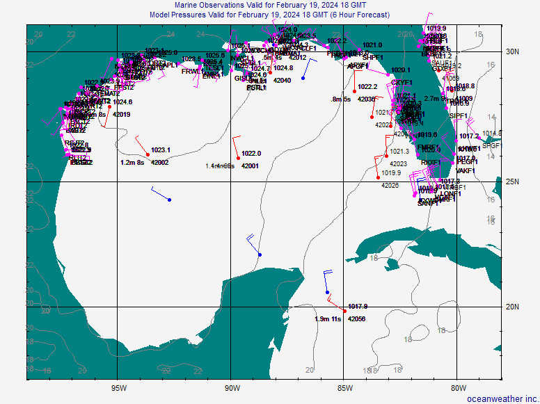
Trugunzn wrote:one of the ships reported 1008 mb pressure
SHIP S 1800 28.20 -88.60 208 77 30 4.6 - 1.0 4.0 - - 1008.0
That just doesn't look right ...
Station 42040 which is at 29.18 N 88.21 W or (roughly) 70 NM away is reporting 1014.2 mb
So we're supposed to have over a 6 mb gradient in that distance? I doubt it.
EDIT: Let's put it this way .... with a gradient like that, I'd expect a heck of a lot more than 10 knot winds at 42040.
Last edited by x-y-no on Tue Aug 15, 2006 2:49 pm, edited 1 time in total.
0 likes

-
Stormcenter
- S2K Supporter

- Posts: 6687
- Joined: Wed Sep 03, 2003 11:27 am
- Location: Houston, TX
Click on the "fronts" box at the top of this loop and you will see something interesting.
http://www.ssd.noaa.gov/goes/east/gmex/loop-avn.html
http://www.ssd.noaa.gov/goes/east/gmex/loop-avn.html
0 likes
-
gatorcane

- S2K Supporter
- Posts: 23703
- Age: 47
- Joined: Sun Mar 13, 2005 3:54 pm
- Location: Boca Raton, FL
Stormcenter wrote:Click on the "fronts" box at the top of this loop and you will see something interesting.
http://www.ssd.noaa.gov/goes/east/gmex/loop-avn.html
Me thinks I see a surface low on this map
This will really get the GOMers going
0 likes

I would take this with a grain of salt but Mike Seidel on TWC tropical update said that they were watching it because it persists for about 6 to 8 hours now, and he says there is area of low pressure stationary and if it persists another 8 to 10 hours they maybe more concerned about it and that a plane will "no doubt" fly into it tomorrow.
0 likes
-
PTrackerLA

- Category 5
- Posts: 5281
- Age: 42
- Joined: Thu Oct 10, 2002 8:40 pm
- Location: Lafayette, LA
gatorcane wrote:Stormcenter wrote:Click on the "fronts" box at the top of this loop and you will see something interesting.
http://www.ssd.noaa.gov/goes/east/gmex/loop-avn.html
Me thinks I see a surface low on this map
This will really get the GOMers going
Notice the surface low is placed east of most of the convection.
0 likes
Stormcenter wrote:Click on the "fronts" box at the top of this loop and you will see something interesting.
http://www.ssd.noaa.gov/goes/east/gmex/loop-avn.html
Well if the T-storms persist they will have a Invest up tommorow morning.
0 likes


Blobbicane Blobby
I note that there has been some heated discussion on the GOM blob in the Jeff Masters Blog on Wunderground. Some wonder if it was just a blob, and one poster called it "Blobbicane Blobby". It's not mentioned in NHC's Atlantic Outlook, but someone on that blog said that this could become Debby. If so, then it's not a blob; it's a deb. Debbicane Debby.
If it becomes an invest, nothing much will happen, but it turns into a tropical depression, the hypermedia will get a hold of it, and oil will go up in price by 2-3 dollars a barrel.
If it becomes an invest, nothing much will happen, but it turns into a tropical depression, the hypermedia will get a hold of it, and oil will go up in price by 2-3 dollars a barrel.
0 likes


700 to 850 layer
http://cimss.ssec.wisc.edu/tropic/real- ... g8dlm1.GIF
500 to 850 layer
http://cimss.ssec.wisc.edu/tropic/real- ... g8dlm2.GIF
http://cimss.ssec.wisc.edu/tropic/real- ... g8dlm1.GIF
500 to 850 layer
http://cimss.ssec.wisc.edu/tropic/real- ... g8dlm2.GIF
0 likes
Who is online
Users browsing this forum: Google [Bot] and 38 guests