DAY 3 CONVECTIVE OUTLOOK
NWS STORM PREDICTION CENTER NORMAN OK
0228 AM CDT TUE AUG 22 2006
VALID 241200Z - 251200Z
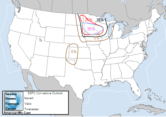
...THERE IS A SLGT RISK OF SVR TSTMS ACROSS PORTIONS OF THE NRN
PLAINS TO THE UPPER GREAT LAKES...
UPCOMING DAY3 APPEARS TO BE SETTING UP TO BE A VERY ACTIVE
CONVECTIVE PERIOD ACROSS PORTIONS OF THE NRN PLAINS INTO THE UPPER
GREAT LAKES REGION. MODELS ARE IN GENERAL AGREEMENT THAT WLY FLOW
WILL GRADUALLY STRENGTHEN ALONG THE U.S./CANADIAN BORDER OVER THE
NEXT FEW DAYS. WITHIN THIS FLOW SEVERAL SIGNIFICANT SHORTWAVE
TROUGHS WILL MOVE EWD INDUCING ORGANIZED DEEP CONVECTION. THE MAIN
SHORTWAVE OF INTEREST THURSDAY WILL MOVE ACROSS THE DAKOTAS INTO MN
DURING THE AFTERNOON HOURS. THIS FEATURE SHOULD INDUCE SFC
CYCLOGENESIS ALONG E-W BOUNDARY THAT WILL BE DRAPED ACROSS SD EARLY
IN THE PERIOD...SUBSEQUENT MOVEMENT WILL BE ENEWD INTO SERN SD/SWRN
MN BY 21-00Z TIME FRAME. VERY MOIST BOUNDARY LAYER AIR WILL
ACCOMPANY THE NWD RETURN OF THE FRONTAL ZONE INTO THE UPPER MS
VALLEY AHEAD OF UPPER TROUGH.
AT THIS TIME IT APPEARS BOUNDARY LAYER BUOYANCY WILL BECOME
MDT-EXTREME IMMEDIATELY AHEAD OF SFC LOW-EWD ALONG WARM FRONT INTO
SRN MN. NEEDLESS TO SAY...THERMODYNAMIC ENVIRONMENT WILL BECOME
VERY FAVORABLE FOR STRONG UPDRAFT DEVELOPMENT. ADDITIONALLY...LARGE
SCALE ASCENT AHEAD OF SHORTWAVE AND STRONG SHEAR PROFILES WILL FAVOR
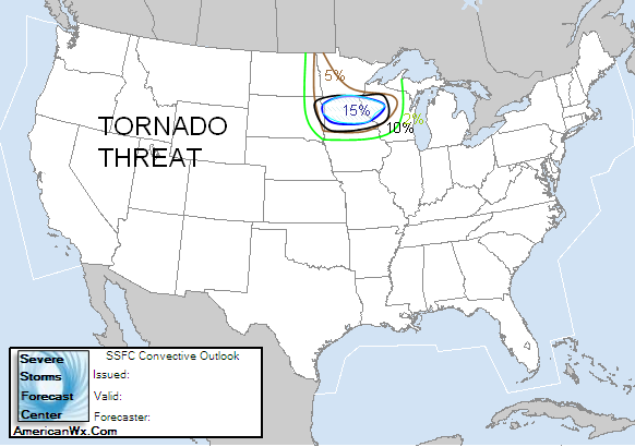
SUPERCELL DEVELOPMENT. FORECAST SOUNDINGS SUGGEST TORNADIC
SUPERCELLS ARE POSSIBLE IF BOUNDARY LAYER CONVECTION DOES DEVELOP
NEAR THE RETREATING WARM FRONT...ESPECIALLY ACROSS PORTIONS OF
CNTRL/SRN MN INTO WCNTRL WI. ADDITIONALLY...SEVERE ELEVATED
CONVECTION MAY ALSO OCCUR WITHIN STRONG WARM ADVECTION ZONE WELL
NORTH OF THE RETREATING BOUNDARY. IF DAY2 CONVECTION DOES NOT
DISRUPT MOISTURE FIELD...AND TIMING OF UPPER TROUGH COINCIDES WITH
PEAK HEATING AS IS CURRENTLY FORECAST...POTENTIALLY SIGNIFICANT
SEVERE EVENT MAY DEVELOP. WILL MONITOR FOR POSSIBLE UPGRADE AS THIS
SCENARIO UNFOLDS.
..DARROW.. 08/22/2006
TORNADO WATCH ND/SD/IA/MN/WI
Moderator: S2k Moderators
Forum rules

The posts in this forum are NOT official forecast and should not be used as such. They are just the opinion of the poster and may or may not be backed by sound meteorological data. They are NOT endorsed by any professional institution or STORM2K.
-
conestogo_flood
- Category 5

- Posts: 1268
- Joined: Wed Sep 28, 2005 5:49 pm
TORNADO WATCH ND/SD/IA/MN/WI
Last edited by conestogo_flood on Thu Aug 24, 2006 3:38 pm, edited 5 times in total.
0 likes


it looks and sounds like (as of right now) that southern MN/northern IA/southern WI will likely be the area for the biggest risk for supercells and tornadoes. this is very unusual to see a 30% risk area in the Day 3 outlook, so the SPC obviously thinks this will be big. In the discussion for the Day 3 outlook, they clearly state that the warm front will move into southern MN during the day, and with peak heating, and what looks like a good moisture flow, they are expecting this to be a very active day. however, they also stated very clearly that any convection that moves through overnight/during the morning may disrupt the moisture flow, therefore the storms wont be as bad, but if the morning convection and residual cloud cover move through fast enough, the moisture flow and peak heating will be in place ahead of the warm front and will likely create perfect conditions for supercells/tornadoes. the one thing i'm not sure of right now is the cap, i dont remember what the SPC said about the cap, and i haven't taken a look at models yet to see how strong the cap is, so that might be the only problem if everything else can get in place.
0 likes
-
WindRunner

- Category 5
- Posts: 5803
- Age: 35
- Joined: Fri Jul 29, 2005 8:07 pm
- Location: Warrenton, VA, but Albany, NY for school
- Contact:
NAM definately supports a central to southern WI tornado threat in the 3km helicity, and sig tornado paramaters reaching up to 6 in central WI after sunset Thursday night! Also good support for SE MN as well with sig tornado params up to 4, though regular old severe storms seem likely in MN/IA area. Either way, we should easily see this getting a day 2 mod tomorrow.
0 likes
-
WaitingForSiren

- Category 1

- Posts: 383
- Joined: Sun Jan 08, 2006 12:58 pm
- Location: Minneapolis,Minnesota
- Contact:
Day 2 convective outlook...
***Mdt Risk of severe weather indicated from Western MN to western WI***
Slgt risk surrounding MDT risk...
* Major severe weather outbreak possible, with potential for a strong tornado *
Synopsis
Deep surface low will retrogade from central SD to western MN by early thursday evening. With deep low level moisture pooling along a highly sheared warm front IE nearly 90 degree wind vectors inof warm front indicated by NAM with the 500 and 850 MB winds a significant outbreak of supercells appears possible.
ND to WI....
Expect rapid thunderstorm development as early as 18-20 Z inof low pressure center and pressure falls in extreme eastern Dakotas. This activity will strengthen as it heads into MN capable of large tornadic supercells given 4000-5000 CAPE probable and increasing shear via cyclone cycglogenesis. Uncertainties regarding morning convection make this forecast a little complicated. If a large convective cluster forms in the Dakotas late wednesday night the severe threat will be mitigated highly, however, this appears more and more unlikely. Strong substidence should prevent any storms from forming in the dakotas till Thursday afternoon. Given this scenario favored by the models, it appears likely a line of storms will develop by evening from central MN to western WI. Any surface based storm will be capable of a strong tornado given LI's around -8 and 90 degree wind vectors. If a storm can remain discrete or isolated, a long track tornado is possible given favorable wind shear, instability and mesoscale sypnotic elements. Will consider upgrading central MN to western WI to a high risk if confidence about morning convection and cap are resolved.
0 likes
hey, nice to see someone else from the Twin Cities. Just wondering, is this your forecast? cus if it is i like it, since you have everything pretty much centered over Minneapolis.  i haven't looked at models yet and i dont plan on really looking at them because i cant chase this.
  i have to work on what looks to be the best set up this year for MN.
0 likes
-
WaitingForSiren
- Category 1
- Posts: 383
- Joined: Sun Jan 08, 2006 12:58 pm
- Location: Minneapolis,Minnesota
- Contact:
Hey! yeah figured might as well come here since Im banned from easternuswx lol. Anyway, 00z models are great. <=1000mb low over western MN by evening. what a nice set up.
tonight looks active as well with a svr wx watch in palce and a big blog of storms in the dakotas headed this way.
looks fine! =)
tonight looks active as well with a svr wx watch in palce and a big blog of storms in the dakotas headed this way.
looks fine! =)
0 likes
-
conestogo_flood
- Category 5
- Posts: 1268
- Joined: Wed Sep 28, 2005 5:49 pm
-
chizniz16

- Tropical Depression

- Posts: 61
- Joined: Sun Feb 12, 2006 12:47 pm
- Location: Southern Minnesota
- Contact:
Keeping an intrest on Thursday evening severe weather chances. This is setting up to be one of the best opportunities this year for severe weather throughout all of Minnesota. Deep convention will be setting up followed by a great ammount of humidity that will leave us with a very moist boundary layer. Once the low comes in contact with this new layer the atmosphere will become very favorable for a number of very strong dynamics that are neccesary to produce a big severe weather event. It is most likely that these storms will be supercellular, and could contain a very powerful updraft not regularly seen in this part of the country. Allowing good oppertunities for large hail and possibily damaging tornadoes. The timing here is very favorable for the worst possible scenario that is allowed in this case. The boundary should arrive between early afternoon and evening, allowing peak heating to take place priming the atmosphere for a potential significant severe weather event. The only possible change in all of this is if Wednsdays convection disrupts our chances on Thursday, but that does not look likely as of now for the southern half of Minnesota. Currently Day 3 outlook features a 30% risk of severe weather and will likely be upgraded each day as we get closer to Thursday evening. Will monitor for possible upgrade at this opportunity unfolds.

0 likes
-
conestogo_flood
- Category 5
- Posts: 1268
- Joined: Wed Sep 28, 2005 5:49 pm
They didn't issue an MDT. This outlook does not sound to convincing anymore...
DAY 2 CONVECTIVE OUTLOOK
NWS STORM PREDICTION CENTER NORMAN OK
1257 AM CDT WED AUG 23 2006
VALID 241200Z - 251200Z
...THERE IS A SLGT RISK OF SVR TSTMS FROM THE NRN/CNTRL PLAINS TO
THE UPPER GREAT LAKES...
DEEP CONVECTION SHOULD READILY DEVELOP ACROSS MUCH OF THE NRN PLAINS
INTO THE UPPER MS VALLEY REGION THURSDAY AHEAD OF SHORTWAVE TROUGH
AND UPPER HEIGHT FALLS. WHILE MODELS REMAIN CONSISTENT IN EJECTING
SHORTWAVE ACROSS THE DAKOTAS BY EARLY EVENING...LOW LEVEL WARM
ADVECTION MAY PROVE AS MUCH RESPONSIBLE FOR EXPECTED THUNDERSTORM
DEVELOPMENT FROM ND INTO CNTRL MN...TO THE NORTH OF THE WELL DEFINED
WARM FRONTAL ZONE.
LATEST THINKING IS THUNDERSTORM CLUSTERS MAY EVOLVE EARLY IN THE
PERIOD ACROSS WRN ND...POSSIBLY AN EXTENSION OF OVERNIGHT ACTIVITY
THAT SPREADS ACROSS MT AHEAD OF UPPER SHORTWAVE. AN MCS MAY EVOLVE
WITHIN STRONG ZONE OF FORCING AND PROPAGATE EWD...WELL TO THE NORTH
OF E-W WIND SHIFT. HAIL IS THE MOST LIKELY SEVERE THREAT WITH THIS
ELEVATED CONVECTION.
WITH TIME BOUNDARY LAYER INSTABILITY SHOULD INCREASE NEAR THE WARM
FRONT ACROSS SERN SD INTO SRN MN/NRN IA...IMMEDIATELY AHEAD OF SFC
LOW. THIS ZONE IS THE MOST LIKELY REGION FOR BOUNDARY LAYER
SUPERCELL DEVELOPMENT DURING THE LATE AFTERNOON HOURS. FORECAST
SOUNDINGS SUGGEST CAP WILL HOLD MUCH OF THE DAY ACROSS THE WARM
SECTOR...WITH SUSTAINED ASCENT NEAR THE FRONT EXPECTED TO WEAKEN THE
INHIBITION SUFFICIENTLY FOR NEAR SFC-BASED UPDRAFTS AFTER 21Z. IF
STORMS CAN INDEED DEVELOP ALONG THE WARM FRONT IT APPEARS EWD STORM
MOTIONS WOULD PROVE FAVORABLE FOR SUSTAINED HIGHER HELICITY
INFLOW...WITH THE POSSIBILITY FOR A FEW TORNADOES. OTHERWISE...AN
EXPANDING ZONE OF WARM ADVECTION...ELEVATED THUNDERSTORMS SHOULD
EVOLVE ACROSS CNTRL MN INTO WI DURING THE OVERNIGHT HOURS.
TRAILING COLD FRONT WILL LIKELY AID IN THE INITIATION OF HIGH BASED
MULTI-CELL...POSSIBLY SUPERCELLULAR...THUNDERSTORMS FROM CNTRL NEB
INTO NWRN KS BY 00Z. THIS ACTIVITY SHOULD PROPAGATE SWD THROUGH THE
CENTRAL PLAINS ENHANCED BY INCREASING LLJ ACROSS KS DURING THE
OVERNIGHT HOURS. WIND AND SOME HAIL SHOULD BE THE PRIMARY THREATS
WITH THIS ACTIVITY.
..DARROW.. 08/23/2006
0 likes
-
WindRunner
- Category 5
- Posts: 5803
- Age: 35
- Joined: Fri Jul 29, 2005 8:07 pm
- Location: Warrenton, VA, but Albany, NY for school
- Contact:
-
conestogo_flood
- Category 5
- Posts: 1268
- Joined: Wed Sep 28, 2005 5:49 pm
-
WindRunner
- Category 5
- Posts: 5803
- Age: 35
- Joined: Fri Jul 29, 2005 8:07 pm
- Location: Warrenton, VA, but Albany, NY for school
- Contact:
conestogo_flood wrote:Today isn't so great anymore. 2% tornado and 15% hail/wind. Hopefully tomorrow is severe.
If nothing too good pops today, then tomorrow will be looking prime. Still thinking that the SPC needs to stretch the 30% for tomorrow further east to include central WI, bu that is more of a tornado threat there as severe params aren't great with the CAPE forecast to peak at around 2000, so I suppose any risk over there will be addressed with the categorical stuff tomorrow. It's making me regret the plans I made for tomorrow afternoon/evening . . .
0 likes
Return to “USA & Caribbean Weather”
Who is online
Users browsing this forum: No registered users and 75 guests