TORNADO WATCH ND/SD/IA/MN/WI
Moderator: S2k Moderators
Forum rules

The posts in this forum are NOT official forecast and should not be used as such. They are just the opinion of the poster and may or may not be backed by sound meteorological data. They are NOT endorsed by any professional institution or STORM2K.
-
conestogo_flood
- Category 5

- Posts: 1268
- Joined: Wed Sep 28, 2005 5:49 pm
-
chizniz16

- Tropical Depression

- Posts: 61
- Joined: Sun Feb 12, 2006 12:47 pm
- Location: Southern Minnesota
- Contact:
Wow that is the longest time I have freaked out about an outlook!
Long story short I have to wear a heart monitor overnight because I had surgery when I was younger and im due for a checkup. So today was the day I wore it and I have to sleep with it on but tomorrow it comes off. I have to write down all the activities I do so they know why it beats so fast at times.. IDK how im gonna explain MY HEART FREAKING OUT BEATTING A MILE A MINUTE AT 1:10 AM. IM GOING TO HAVE TO WRITE THIS DOWN AND TALK TO THE DOCTOR ABOUT IT TOMORROW, LOL ONLY A WEATHER NERD..
Long story short I have to wear a heart monitor overnight because I had surgery when I was younger and im due for a checkup. So today was the day I wore it and I have to sleep with it on but tomorrow it comes off. I have to write down all the activities I do so they know why it beats so fast at times.. IDK how im gonna explain MY HEART FREAKING OUT BEATTING A MILE A MINUTE AT 1:10 AM. IM GOING TO HAVE TO WRITE THIS DOWN AND TALK TO THE DOCTOR ABOUT IT TOMORROW, LOL ONLY A WEATHER NERD..
0 likes

-
WaitingForSiren

- Category 1

- Posts: 383
- Joined: Sun Jan 08, 2006 12:58 pm
- Location: Minneapolis,Minnesota
- Contact:
Why yes, yes I am indeed.


DAY 1 CONVECTIVE OUTLOOK...ISSUED AT 06Z
THERE IS A HIGH RISK OF SEVERE WEATHER FROM EXTREME EASTERN SOUTH DAKOTA ACROSS SOUTHERN MN...
THERE IS A MDT RISK OF SEVERE WEATHER FROM THE EASTERN DAKOTAS TO WESTERN WI...
THERE IS A SLGT RISK OF SEVERE WEATHER FROM NEBRASKA TO WI...
THERE IS A SLGT RISK OF SEVERE WEATHER FROM PA-THE NORTHERN MID ATLANTIC...
* MAJOR SEVERE WEATHER OUTBREAK IS POSSIBLE THIS AFTERNOON AND EVENING INTO TONIGHT... WITH POTENTIAL FOR DAMAGING TORNADOES, WIDESPREAD WIND DAMAGE AND DESTRUCTIVE HAIL *
SYNOPSIS...
UNUSUALLY DYNAMIC SITUATION SETTING UP ACROSS THE PLAINS. UNTAPPED AND EXTREME BOUYANCY CURRENTLY EXISTS ACROSS NEBRASKA AND THE DAKOTAS INTO SOUTHERN MN AND SW WI. THIS UNSTABLE AIRMASS WILL LIFE NORTHWARD BENEATH A STRONG WARM FRONT, AND NORTH OF THIS WARM FRONT BY EVENING. LOW PRESSURES IN THE DAKOTAS WILL CONSOLIDATE INTO TWO MAIN CENTERS..ONE IN CENTRAL ND AND ONE IN EASTERN SD BY EVENING. WARM FRONT WILL SAG FROM EASTERN SD TO MSLP TO SW WISCONSIN. CURRENT THINKING IS MODELS ARE TOO FAR SOUTH WITH THE WARM FRONT AS EVIDENT ON SAT IMAGERY, RADAR IMAGERY AND SURFACE ANALYSIS. THUS WILL BRING MDT RISK FURTHER NORTH.
DISCUSSION...
DAKOTAS TO WI THIS EVENING...
AS PRESSURE FALLS EXPAND INTO THIS AREA THIS AFTERNOON, EXPECT RAPID THUNDERSTORM DEVELOPMENT POSSIBLE IN SEVERAL AREAS. ONE BEING IN EASTERN SD AHEAD OF LOW CENTER, AND ONE IN SOUTHERN MINNESOTA ALONG SLOWLY LIFTING WARM FRONT. ACTIVITY MAY BE ELEVATED AT FIRST, BUT EXPECT SURFACE BASED SUPERCELLS BY MID AFTERNOON AS CELLS ROOT INTO THE EXTREME INSTABILITY. LI'S AROUND -8 TILL SUPPORT INTENSE UPDRAFTS IN STORMS. EXPECT SEVERAL REPORTS OF HAIL GREATER THAN 2 INCHES WITHIN THE MDT AND HIGH RISK AREAS DUE TO THIS. ALSO, THERE IS A POTENTIAL FOR A DERECHO IF A BOW ECHO CONSOLIDATION CAN OCCUR IN WEST CENTRAL MN THIS AFTERNOON. THIS MAY MITIGATE THE TORNADO THREAT, BUT EITHER WAY HIGH RISK AREA LOOKS PRIME FOR TORNADIC EVENTS AS THIS SCENARIO WOULD STILL FAVOR A LEWP TYPE TORNADO OR A SOUTHERN TAIL TORNADO.
GIVEN THE INSTABILITY, STRONG PARAMETERS, STRONG SURFACE HEATING AND GOOD INSOLATION, EXPECT A FEW STRONG TORNADOES TO BE LIKELY GIVEN STORM INITIATION OCCURS IN SOUTHERN MN AND EASTERN SD. ACTIVITY WILL LIFT NORTHEASTWARD THROUGHOUT THE NIGHT AND A CONTINUED RISK OF SIGNFICANT SEVERE WEATHER WILL PERSIST. IF A BOW ECHO FORMS IN MN THIS AFTERNOON, WIDESPREAD WIND DAMAGE COULD OCCUR WELL INTO WI TONIGHT.
NE...
EXPECT A FEW SEVERE ORGANIZED STORMS ALONG WEAK LOW IN PA THIS AFTERNOON, ACTIVITY SHOULD DIMINISH SHORTLY AFTER SUNSET.
NORTHERN OHIO VALLEY...
BOUNDARIES FROM OVERNIGHT STORMS MIGHT SPARK PULSE SEVERE STORMS THIS AFTERNOON...ACTIVITY WILL DIMINISH AFTER SUNSET..
DESERT REGION...
PULSE SEVERE STORMS ARE POSSIBLE. ACTIVITY WILL BE BRIEF AND SHORTLY DIMINISH AFTER SUNSET.
DAVE
0 likes
-
WindRunner

- Category 5
- Posts: 5803
- Age: 35
- Joined: Fri Jul 29, 2005 8:07 pm
- Location: Warrenton, VA, but Albany, NY for school
- Contact:
-
WaitingForSiren
- Category 1
- Posts: 383
- Joined: Sun Jan 08, 2006 12:58 pm
- Location: Minneapolis,Minnesota
- Contact:
-
chizniz16
- Tropical Depression
- Posts: 61
- Joined: Sun Feb 12, 2006 12:47 pm
- Location: Southern Minnesota
- Contact:
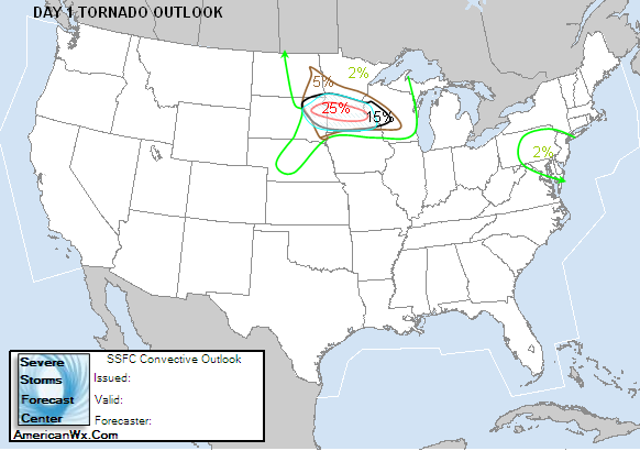
Dave, your prolly in class right now, but big props to you on the high risk, bringing it that far north. the new SPC just about confirms that exact spot for a hatched tornado area of 15%, they brought it further north like you said they would. Im still trying to hook up with Jayson and chase SW MN today.
0 likes
-
conestogo_flood
- Category 5
- Posts: 1268
- Joined: Wed Sep 28, 2005 5:49 pm
Wow, 15% tornado and hatched. Good luck everyone in that area. Remember to warn your friends and family to watch the weather today. It has been a long time since anything major has happened in this region, so severe weather could possibly be just a distant memory to some. Remember to listen for your weather radios, call ANYONE you might need to in the event. Even if it is on the other side of the state, if tornadoes are coming, any warning to anyone is needed. Listen for the tornado sirens if the power goes out, and also have some supplies ready in your basements or other shelters. Don't do anything stupid, and chase responsibly.
0 likes
-
conestogo_flood
- Category 5
- Posts: 1268
- Joined: Wed Sep 28, 2005 5:49 pm
Let the outbreak begin?
TORNADO WARNING
NATIONAL WEATHER SERVICE BISMARCK ND
843 AM MDT THU AUG 24 2006
THE NATIONAL WEATHER SERVICE IN BISMARCK HAS ISSUED A
* TORNADO WARNING FOR...
CENTRAL MERCER COUNTY IN SOUTH CENTRAL NORTH DAKOTA...
* UNTIL 915 AM MDT
* AT 838 AM MDT...NATIONAL WEATHER SERVICE DOPPLER RADAR INDICATED A
SEVERE THUNDERSTORM CAPABLE OF PRODUCING A TORNADO 7 MILES
NORTHWEST OF HAZEN...OR ABOUT 58 MILES NORTHEAST OF DICKINSON...
MOVING EAST AT 25 MPH.
* THE TORNADO WILL BE NEAR...
HAZEN AROUND 850 AM MDT...
0 likes
-
WaitingForSiren
- Category 1
- Posts: 383
- Joined: Sun Jan 08, 2006 12:58 pm
- Location: Minneapolis,Minnesota
- Contact:
-
wxmann_91

- Category 5
- Posts: 8007
- Age: 34
- Joined: Fri Jul 15, 2005 2:49 pm
- Location: Southern California
- Contact:
WaitingForSiren wrote:If i had o pick a chase target Id go for Wilmar, MN. looks like that area should be prime for tornadic supercells by afternoon. definitely interesting morning here with numerous hailstorms. i saw a report of 4.25 inch hail just south of me...WOW!
Have you ever gone chasing Dave?
0 likes
-
conestogo_flood
- Category 5
- Posts: 1268
- Joined: Wed Sep 28, 2005 5:49 pm
Moderate risk got smaller, so did the 15% tornado and hatched area. Minn/St. Paul is only between 10% and 5% tornado now.
Last edited by conestogo_flood on Thu Aug 24, 2006 11:56 am, edited 1 time in total.
0 likes
-
conestogo_flood
- Category 5
- Posts: 1268
- Joined: Wed Sep 28, 2005 5:49 pm
This area is being blanketed by severe thunderstorm watches. How come tornado watches are not being issued?
Last edited by conestogo_flood on Thu Aug 24, 2006 12:05 pm, edited 1 time in total.
0 likes
-
wxmann_91
- Category 5
- Posts: 8007
- Age: 34
- Joined: Fri Jul 15, 2005 2:49 pm
- Location: Southern California
- Contact:
You mean not issued, right, Conestogo.
Reason is, attm, most of these storms are elevated above a stable boundary layer, thus the tornado chance is quite minimal. As the boundary layer destabilizes in the afternoon, then the supercells can become sfc-based, in which a tornado watch would likely be issued.
Reason is, attm, most of these storms are elevated above a stable boundary layer, thus the tornado chance is quite minimal. As the boundary layer destabilizes in the afternoon, then the supercells can become sfc-based, in which a tornado watch would likely be issued.
0 likes
Return to “USA & Caribbean Weather”
Who is online
Users browsing this forum: AnnularCane and 66 guests