TS Ernesto #9 Sat pics, models,analysis thread

This is the general tropical discussion area. Anyone can take their shot at predicting a storms path.

Moderator: S2k Moderators

Forum rules

The posts in this forum are NOT official forecasts and should not be used as such. They are just the opinion of the poster and may or may not be backed by sound meteorological data. They are NOT endorsed by any professional institution or STORM2K. For official information, please refer to products from the National Hurricane Center and National Weather Service.

Help Support Storm2K
Message
Author
User avatar
A1A
Tropical Storm
Tropical Storm
Posts: 156
Joined: Mon Oct 17, 2005 1:03 pm
Location: Central Texas

#381 Postby A1A » Sat Aug 26, 2006 9:59 am

HouTXmetro wrote:Can you give us a link to the NHC archives for models?


For NHC archive info, go to NHC page and click on Seaons Archive


then go to
Hurricane Season Tropical Cyclone Product Archives

then go to year, i.e. 2005

Click on the storm of interest, then note there is a Graphics Archive link at the top,
most likely you want to go to the Grapics Archive

i.e. here the link for graphics archive for Katrina and Rita
Katrina: http://www.nhc.noaa.gov/archive/2005/KATRINA_graphics.shtml
Rita: http://www.nhc.noaa.gov/archive/2005/RITA_graphics.shtml
Last edited by A1A on Sat Aug 26, 2006 10:02 am, edited 1 time in total.
0 likes   

CYCLONE MIKE
Category 5
Category 5
Posts: 2183
Joined: Tue Aug 31, 2004 6:04 pm
Location: Gonzales, LA

#382 Postby CYCLONE MIKE » Sat Aug 26, 2006 9:59 am

PT you are exactly correct. I stated earlier that how many times Katrina track was changed further to the west because the weakness was not that significant enough to turn her like the models were showing. Give it about two more days and once the GFS realizes the front will be weaker and the high not as broken down they will shift more to the left again.
0 likes   

User avatar
timeflow
Tropical Depression
Tropical Depression
Posts: 99
Age: 53
Joined: Tue Jul 05, 2005 5:48 pm
Location: Orlando, FL
Contact:

#383 Postby timeflow » Sat Aug 26, 2006 10:00 am

Image
Image
0 likes   

sevenleft
Category 1
Category 1
Posts: 315
Joined: Sat Aug 05, 2006 2:36 pm

#384 Postby sevenleft » Sat Aug 26, 2006 10:01 am

Ritas track shifted east east east. Katrinas track shifted west west west.

Everyone from Texas to the Florida PENINSULA has to watch Ernesto. Recurvature into the west coast of FL is a scenario.
0 likes   

User avatar
ALhurricane
Professional-Met
Professional-Met
Posts: 452
Joined: Wed Jan 08, 2003 12:46 pm
Location: Daphne, AL

#385 Postby ALhurricane » Sat Aug 26, 2006 10:01 am

gatorcane wrote:
x-y-no wrote:
gatorcane wrote:
x-y-no wrote:
Wherever this goes on the Gulf coast, this is starting to look very very grim.


And I see Derek is now taking it to a Cat 4. :eek:


Some are saying now it could slow and then bend into the west coast of FL..... :eek:


Yeah, obviously the panhandle can't be ruled out. I'd say the peninsula is as close to being ruled out as anything ever is (Ernesto would have to slow down significantly south of Cuba for the peninsula to come into play).

Right now my concern is highest for Louisiana - but yesterday I was still thinking more in terms of Texas (which is certainly still a possibilty too), so the trend has been eastward.


that is my point. We have gone from Mexico now to LA and FL panhandle and now the NHC says it will slow down.

I have a bad feeling it is going to slow and bend into the West Coast of FL.


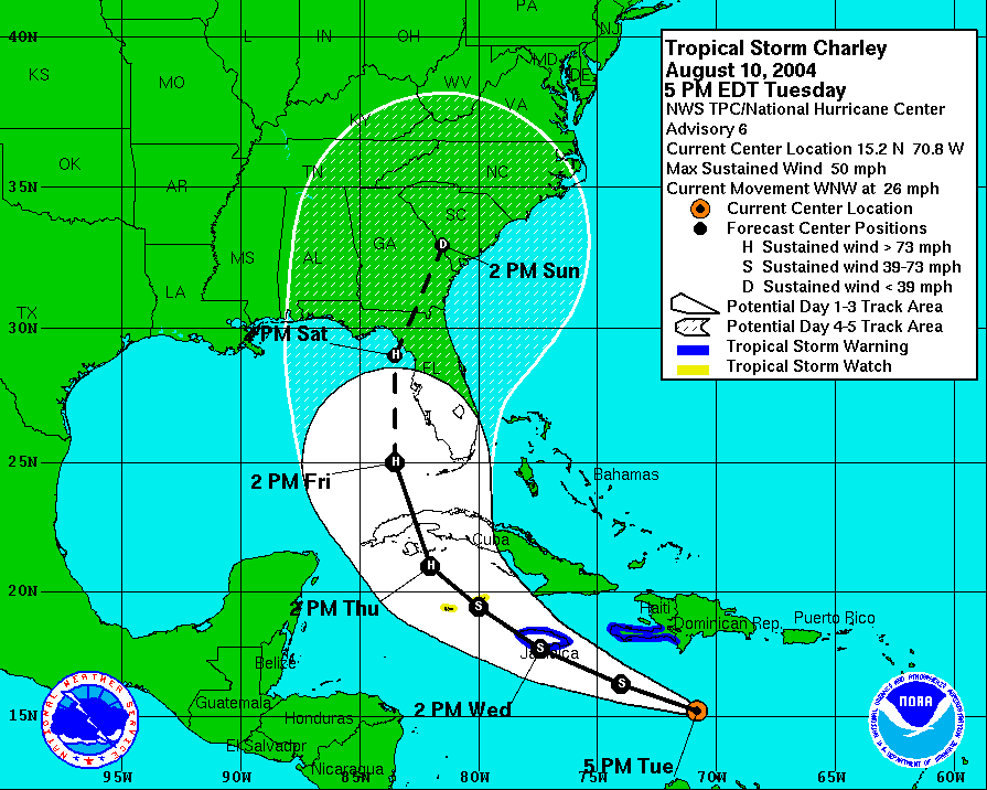
While it is always good to be cautious, there is no data out there to support the west coast of FL is at much risk. There is a big difference in a turn to the north (meaning the difference in TX or the FL Panhandle) and a dramatic turn to the east. For that to happen, you would need a Charley like trough to dig down into the Gulf. That is not going to happen.
0 likes   

User avatar
beachbum_al
Category 5
Category 5
Posts: 2163
Age: 55
Joined: Thu Jul 14, 2005 9:23 pm
Location: South Alabama Coast
Contact:

#386 Postby beachbum_al » Sat Aug 26, 2006 10:02 am

And how many times have we sat here and watch a storm form and the computer models showed it coming toward us and then it turned to the East at the last minute. I can same several from just 2004 and 2005 seasons that did this. Ummm! Ivan, Dennis, Katrina are all examples of why you should be prepare and not follow the little dotted line. For instance Ivan was headed for the MS/AL state line. It went in at Gulf Shores, AL. Believe me I know becaue I was in it! Then Dennis was headed straight for Mobile Bay. Last few hours Dennis went toward FL. I remember well because the Governor of Alabama office was calling everyone down here south of I-10 to leave because a strong Cat 4 or 5 could be going up Mobile Bay. Memories I prefer to forget! Katrina is another example. Katrina was going toward FL, then the big bend of FL and then Mobile, and then MS, and then TX. Katrina eventually made land fall in LA, east of NO and made a second landfall in MS I believe. If I am wrong please correct me. One lesson I learned is that don't follow the dotted line on the cone. Storms can go anywhere.
0 likes   

User avatar
gatorcane
S2K Supporter
S2K Supporter
Posts: 23692
Age: 47
Joined: Sun Mar 13, 2005 3:54 pm
Location: Boca Raton, FL

#387 Postby gatorcane » Sat Aug 26, 2006 10:02 am

sevenleft wrote:Ritas track shifted east east east. Katrinas track shifted west west west.

Everyone from Texas to the Florida PENINSULA has to watch Ernesto. Recurvature into the west coast of FL is a scenario.


thanks I think many peninsula Floridians think they are out of the woods....not yet....they need to watch this thing. If it slows enough then FL may be hit.
0 likes   

sevenleft
Category 1
Category 1
Posts: 315
Joined: Sat Aug 05, 2006 2:36 pm

#388 Postby sevenleft » Sat Aug 26, 2006 10:02 am

timeflow - the same thing crossed my mind when I read the 11AM discussion. I was thinking "Charley" as a possibility.
0 likes   

ThunderMate
Tropical Storm
Tropical Storm
Posts: 215
Joined: Mon Jul 11, 2005 10:18 am
Location: Virginia Beach, Virginia
Contact:

#389 Postby ThunderMate » Sat Aug 26, 2006 10:02 am

Dude, i don't know what to say except this looks like it could potentially be REAL bad for anyone especially N.O.... Also is the wall finished yet or not b/c if its not then this could be even worse....
0 likes   

User avatar
ALhurricane
Professional-Met
Professional-Met
Posts: 452
Joined: Wed Jan 08, 2003 12:46 pm
Location: Daphne, AL

#390 Postby ALhurricane » Sat Aug 26, 2006 10:03 am

sevenleft wrote:Ritas track shifted east east east. Katrinas track shifted west west west.

Everyone from Texas to the Florida PENINSULA has to watch Ernesto. Recurvature into the west coast of FL is a scenario.


I completely disagree. There is absolutely no data to support such a scenario.
0 likes   

User avatar
skysummit
S2K Supporter
S2K Supporter
Posts: 5305
Age: 49
Joined: Tue Aug 31, 2004 11:09 pm
Location: Ponchatoula, LA
Contact:

#391 Postby skysummit » Sat Aug 26, 2006 10:04 am

sevenleft wrote:timeflow - the same thing crossed my mind when I read the 11AM discussion. I was thinking "Charley" as a possibility.


Charley is likely not a possiblity. We don't have a strong cold front coming down. We're not going to be in the 50's next weekend. This is a different scenario....we're talking about a trough compared to a strong cold front.
0 likes   

User avatar
Extremeweatherguy
Category 5
Category 5
Posts: 11095
Joined: Mon Oct 10, 2005 8:13 pm
Location: Florida

#392 Postby Extremeweatherguy » Sat Aug 26, 2006 10:04 am

beachbum_al wrote:And how many times have we sat here and watch a storm form and the computer models showed it coming toward us and then it turned to the East at the last minute. I can same several from just 2004 and 2005 seasons that did this. Ummm! Ivan, Dennis, Katrina are all examples of why you should be prepare and not follow the little dotted line. For instance Ivan was headed for the MS/AL state line. It went in at Gulf Shores, AL. Believe me I know becaue I was in it! Then Dennis was headed straight for Mobile Bay. Last few hours Dennis went toward FL. I remember well because the Governor of Alabama office was calling everyone down here south of I-10 to leave because a strong Cat 4 or 5 could be going up Mobile Bay. Memories I prefer to forget! Katrina is another example. Katrina was going toward FL, then the big bend of FL and then Mobile, and then MS, and then TX. Katrina eventually made land fall in LA, east of NO and made a second landfall in MS I believe. If I am wrong please correct me. One lesson I learned is that don't follow the dotted line on the cone. Storms can go anywhere.
good examples. Katrina, however, was never pointed at TX, but it's track did shift west from FL to LA.
0 likes   

User avatar
Dallasis2hot
Tropical Low
Tropical Low
Posts: 10
Joined: Wed Aug 09, 2006 12:47 pm

#393 Postby Dallasis2hot » Sat Aug 26, 2006 10:04 am

gatorcane wrote:okay folks, another conservative track by NHC. FL west coast needs to watch out for this thing. New model runs are pushing it into FL.........


Where besides your posts are people calling for FL west coast hit? What model? I've seen you mention it 3 times, but not seeing it anywhere else, on any other forum, or any model.
0 likes   

conestogo_flood
Category 5
Category 5
Posts: 1268
Joined: Wed Sep 28, 2005 5:49 pm

#394 Postby conestogo_flood » Sat Aug 26, 2006 10:04 am

NHC live on CNN. 1104 am edt.
0 likes   

User avatar
DESTRUCTION5
Category 5
Category 5
Posts: 4423
Age: 43
Joined: Wed Sep 03, 2003 11:25 am
Location: Stuart, FL

#395 Postby DESTRUCTION5 » Sat Aug 26, 2006 10:04 am

ALhurricane wrote:
gatorcane wrote:
x-y-no wrote:
gatorcane wrote:
x-y-no wrote:
Wherever this goes on the Gulf coast, this is starting to look very very grim.


And I see Derek is now taking it to a Cat 4. :eek:


Some are saying now it could slow and then bend into the west coast of FL..... :eek:


Yeah, obviously the panhandle can't be ruled out. I'd say the peninsula is as close to being ruled out as anything ever is (Ernesto would have to slow down significantly south of Cuba for the peninsula to come into play).

Right now my concern is highest for Louisiana - but yesterday I was still thinking more in terms of Texas (which is certainly still a possibilty too), so the trend has been eastward.


that is my point. We have gone from Mexico now to LA and FL panhandle and now the NHC says it will slow down.

I have a bad feeling it is going to slow and bend into the West Coast of FL.


While it is always good to be cautious, there is no data out there to support the west coast of FL is at much risk. There is a big difference in a turn to the north (meaning the difference in TX or the FL Panhandle) and a dramatic turn to the east. For that to happen, you would need a Charley like trough to dig down into the Gulf. That is not going to happen.


Not true..It can slow and the weakness can be further east...THus sending it Polewad earlier
0 likes   

Mac

#396 Postby Mac » Sat Aug 26, 2006 10:04 am

ThunderMate wrote:Dude, i don't know what to say except this looks like it could potentially be REAL bad for anyone especially N.O.... Also is the wall finished yet or not b/c if its not then this could be even worse....


All they did was repair the broken levees. They have not done anything to correct the preexisting problems with the levees. It will take years and years to do that. So, if a strong storm gets close to N.O. again it is quite likely that we'll see a similar outcome. If Ernie were to hit as a major just to the west of N.O., the outcome would be far worse.
0 likes   

User avatar
tailgater
S2K Supporter
S2K Supporter
Posts: 3339
Joined: Sun Jul 11, 2004 9:13 pm
Location: St. Amant La.

#397 Postby tailgater » Sat Aug 26, 2006 10:05 am

Mac wrote:
tailgater wrote: I guess we need to come up with some type of scale.
5-10 knots = low shear
10-20 knots = moderate shear
20-30 knots = strong shear
30-40 knots = very strong shear
40> knots = No chance shear
Pro mets please correct as needed. 8-)


It's not so simple. First of all, it's not merely a matter of how high the shear is but the direction of the shear in relation to the track of the storm. Shear that is moving at 10 knots in the opposite direction of the storm is more destructive than shear moving at 15 knots in the same direction as the storm. Additionally, shear located at the periphery of the storm may actually help to vent the storm...improving its outflow and therefore serving to increase its intensity. And the size and strength of the storm may also factor into the storm's ability to combat the adverse impace of the shear.

So, as you can see...not so cut and dry as coming up with a numerical scale.

That was meant to be a bit joke as to POUNDING being so objective! I said it was getting pounded and AF met said it wasn't.
Last edited by tailgater on Sat Aug 26, 2006 10:11 am, edited 1 time in total.
0 likes   

hurricanesfans27
Tropical Low
Tropical Low
Posts: 17
Joined: Sat Aug 26, 2006 9:12 am

#398 Postby hurricanesfans27 » Sat Aug 26, 2006 10:06 am

conestogo_flood wrote:NHC live on CNN. 1104 am edt.


and they have my state in full view.. just peachy.
0 likes   

User avatar
gatorcane
S2K Supporter
S2K Supporter
Posts: 23692
Age: 47
Joined: Sun Mar 13, 2005 3:54 pm
Location: Boca Raton, FL

#399 Postby gatorcane » Sat Aug 26, 2006 10:07 am

Yes a stronger Ernesto will want to move more poleward. We have seen yesterday that as it strengthens it nudges more north....and it *should* really start to intensify over the next several days.
0 likes   

User avatar
HouTXmetro
Category 5
Category 5
Posts: 3949
Joined: Sun Jun 13, 2004 6:00 pm
Location: District of Columbia, USA

#400 Postby HouTXmetro » Sat Aug 26, 2006 10:07 am

A1A wrote:
HouTXmetro wrote:Can you give us a link to the NHC archives for models?


For NHC archive info, go to NHC page and click on Seaons Archive


then go to
Hurricane Season Tropical Cyclone Product Archives

then go to year, i.e. 2005

Click on the storm of interest, then note there is a Graphics Archive link at the top,
most likely you want to go to the Grapics Archive

i.e. here the link for graphics archive for Katrina and Rita
Katrina: http://www.nhc.noaa.gov/archive/2005/KATRINA_graphics.shtml
Rita: http://www.nhc.noaa.gov/archive/2005/RITA_graphics.shtml


Thank you so kindly
0 likes   
[Disclaimer: My Amateur Opinion, please defer to your local authorities or the NHC for Guidance.]


Return to “Talkin' Tropics”

Who is online

Users browsing this forum: BobHarlem, cajungal, Kingarabian, LarryWx and 45 guests