

Thatsmrhurricane wrote:Forecast track:
http://www.nhc.noaa.gov/
Models page:
http://euler.atmos.colostate.edu/~vigh/guidance/
Thank you very much.
I'll keep those addys now.
Moderator: S2k Moderators

Thatsmrhurricane wrote:Forecast track:
http://www.nhc.noaa.gov/
Models page:
http://euler.atmos.colostate.edu/~vigh/guidance/

Dean4Storms wrote:wxman57 wrote:Another McIDAS image showing the center a bit better:
http://myweb.cableone.net/nolasue/ernesto44.gif
wxman, that is an old pic, the center now is clearly visible south of that liitle thumb of Haiti's for lack of a better description. It is moving more wnw now.
See link, zoom in........
http://www.ssd.noaa.gov/goes/flt/t2/loop-vis.html


wxman57 wrote:Dean4Storms wrote:Zoom in on this Sat. loop, you can clearly see the center and what looks to be an eye trying to clear out. It does look like Ernesto has turned back or wobbles back to the WNW the last few hours or so.
http://www.ssd.noaa.gov/goes/flt/t2/loop-vis.html
Actually, what you're looking at appears to be convection diminishing and the cirrus clouds no longer covering the LLC.

wxman57 wrote:Another McIDAS image showing the center a bit better:
http://myweb.cableone.net/nolasue/ernesto44.gif
wxman57 wrote:Dean4Storms wrote:wxman57 wrote:Another McIDAS image showing the center a bit better:
http://myweb.cableone.net/nolasue/ernesto44.gif
wxman, that is an old pic, the center now is clearly visible south of that liitle thumb of Haiti's for lack of a better description. It is moving more wnw now.
See link, zoom in........
http://www.ssd.noaa.gov/goes/flt/t2/loop-vis.html
Check the time on the bottom, scan time started 1602Z. It's the most recent image available. The image on your loop is 15 minutes older, and much poorer resolution.


Dean4Storms wrote:wxman57 wrote:Dean4Storms wrote:Zoom in on this Sat. loop, you can clearly see the center and what looks to be an eye trying to clear out. It does look like Ernesto has turned back or wobbles back to the WNW the last few hours or so.
http://www.ssd.noaa.gov/goes/flt/t2/loop-vis.html
Actually, what you're looking at appears to be convection diminishing and the cirrus clouds no longer covering the LLC.
We'll have to disagree on that one. If you'll zoom in and slow it down I think you'll see the movement more wnw with the center just south of that thumb as I pointed out.
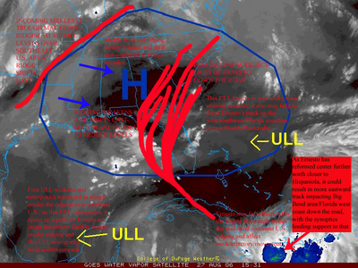
CapeVerdeWave wrote:skysummit wrote:I need help. What exactly is eroding the ridge? I've been studying WV for an hour now and I can't understand. Is it the shortwave trough or the ULL?
Here is a good graphic that indicates what the GFS may have been indicating... it also indicates my thoughts on the synoptics.
wxman57 wrote:Dean4Storms wrote:wxman57 wrote:Dean4Storms wrote:Zoom in on this Sat. loop, you can clearly see the center and what looks to be an eye trying to clear out. It does look like Ernesto has turned back or wobbles back to the WNW the last few hours or so.
http://www.ssd.noaa.gov/goes/flt/t2/loop-vis.html
Actually, what you're looking at appears to be convection diminishing and the cirrus clouds no longer covering the LLC.
We'll have to disagree on that one. If you'll zoom in and slow it down I think you'll see the movement more wnw with the center just south of that thumb as I pointed out.
I'm building a 10-image McICAS loop now. Can't post it here, but It'll be up on my worksttaion shortly. Much higher resolution than you can get online anywhere, and it has 1-deg lat-lon lines on it. Should be done in a minute or two. It COULD be that the center is actually farther NW over the western tip of Haiti.

Users browsing this forum: kevin and 116 guests

