Looks like Ernie is back over water...and the satellite presentation has improved markedly since this morning. Notice the bands that were somewhat disconnected and clumpy have fallen apart and a new band-feature has develop and wraps about 180 degrees to the east and south. The shear is gone...and with the bulk of the circulation back out over water...Earnie is going to start lowering pressures within the next 6 to 12 hours...and the call ofr a hurricane upon entry to Cuba seems reasonable.
Also...it looks to have jogged out to the west just a tad...can't wait to see what the synoptic flights do to the models...
MW
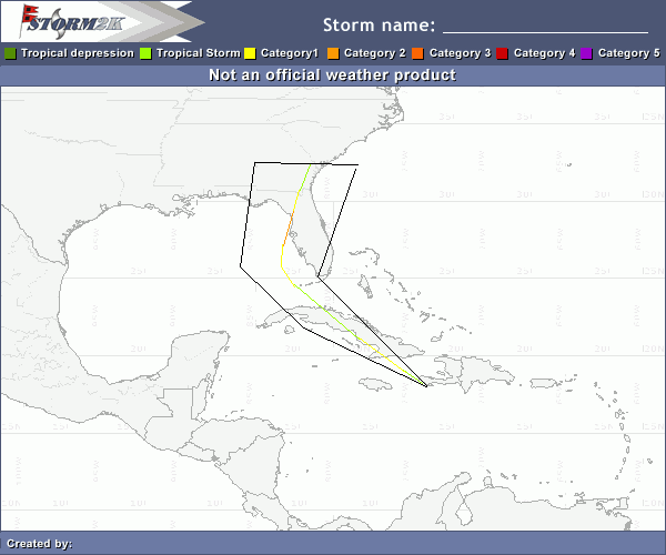
Hurricane Ernesto - Cat. 1
Moderator: S2k Moderators

The key tonight and over the next 12 hrs is the track rather than intensity (which I expect to deepen). If this emerges and tracks more W-NW than I think the GFDL solution may ultimately prevail. If you look at the more eastern NOGAPs and GFS runs, both of these solutions move the storm N-NW just clipping the NE part of Cuba. We'll know by tomorrow morning whether this will be a southern peninsula/east coast storm or a GOM threat.
0 likes
-
Scorpion


MWatkins wrote:Looks like Ernie is back over water...and the satellite presentation has improved markedly since this morning. Notice the bands that were somewhat disconnected and clumpy have fallen apart and a new band-feature has develop and wraps about 180 degrees to the east and south. The shear is gone...and with the bulk of the circulation back out over water...Earnie is going to start lowering pressures within the next 6 to 12 hours...and the call ofr a hurricane upon entry to Cuba seems reasonable.
Also...it looks to have jogged out to the west just a tad...can't wait to see what the synoptic flights do to the models...
MW
What model package should the synoptic flight data be in?
0 likes


-
Derek Ortt
-
caneman
My apologies if posted already. Don't have time to go thru everything 18Z GFS
http://moe.met.fsu.edu/cgi-bin/gfstc2.c ... =Animation
http://moe.met.fsu.edu/cgi-bin/gfstc2.c ... =Animation
0 likes
-
all_we_know_is_FALLING

- Category 1

- Posts: 417
- Joined: Fri Jun 09, 2006 3:06 pm
- Location: Somewhere over the rainbow...
- Contact:

066
SXXX50 KNHC 272309
AF302 0605A ERNESTO HDOB 52 KNHC
2259. 1658N 07301W 01525 0068 194 021 162 156 021 01626 0000000000
2300 1656N 07302W 01523 0068 197 021 168 152 021 01624 0000000000
2300. 1654N 07302W 01525 0068 198 021 168 146 021 01626 0000000000
2301 1652N 07302W 01522 0069 201 020 170 158 021 01624 0000000000
2301. 1652N 07304W 01525 0070 189 019 168 160 020 01628 0000000000
2302 1653N 07305W 01523 0067 181 023 166 160 024 01623 0000000000
2302. 1654N 07307W 01516 0065 179 024 170 154 025 01614 0000000000
2303 1656N 07308W 01523 0064 179 023 170 154 024 01620 0000000000
2303. 1657N 07310W 01525 0065 178 022 172 154 024 01623 0000000000
2304 1659N 07311W 01525 0064 178 022 170 156 022 01622 0000000000
2304. 1700N 07313W 01522 0064 182 020 170 162 021 01619 0000000000
2305 1701N 07314W 01522 0063 186 018 168 160 018 01617 0000000000
2305. 1703N 07315W 01524 0063 187 019 166 162 019 01620 0000000000
2306 1704N 07317W 01524 0062 199 019 166 162 020 01619 0000000000
2306. 1705N 07318W 01524 0061 191 020 164 160 020 01618 0000000000
2307 1707N 07319W 01525 0061 189 020 168 156 020 01619 0000000000
2307. 1708N 07321W 01523 0060 189 021 168 158 021 01616 0000000000
2308 1709N 07322W 01522 0060 188 021 168 156 021 01615 0000000000
2308. 1710N 07323W 01524 0059 190 021 170 156 021 01616 0000000000
2309 1712N 07325W 01525 0059 190 021 176 152 022 01616 0000000000
;

0 likes
-
Jim Cantore
The following post is NOT an official forecast and should not be used as such. It is just the opinion of the poster and may or may not be backed by sound meteorological data. It is NOT endorsed by any professional institution including storm2k.org For Official Information please refer to the NHC and NWS products.
This is assumeing he survives Cuba
Any thoughts?
This is assumeing he survives Cuba
Any thoughts?
0 likes
-
miamicanes177
- Category 5

- Posts: 1131
- Joined: Tue Aug 01, 2006 10:53 pm
We have to watch for trends and not jogs. Jogs do make a difference and just a slight jog could be the difference between a major hurricane entering the gulf and a tropical storm or depression. Cuba is very skinny. It will not take too many jobs and wobbles for it to stay over water.JPmia wrote:Are we expecting a shift more to the west in models b/c of this current jog to the west?
0 likes

-
HurricaneBelle

- S2K Supporter

- Posts: 1209
- Joined: Sun Aug 27, 2006 6:12 pm
- Location: Clearwater, FL
AL Chili Pepper wrote:miamicanes177 wrote:Just a reminder that the chances of this hitting where the NHC says it will this far in advance is VERY small. Pinpointing a location 4 days in advance is impossible in my opinion. We're having a hard time figuring out where it will be 12 hours from now...much less 96 hours. So everyone expecting this to hit in the middle of florida will likely be in for a major shock. I expect we'll have a HUGE track shift to be in line with the GFDL. The panhandle or perhaps alabama could be under the gun.
The next GFDL run will be interesting, along with the next model runs with the NOAA high altitude data. I sure hope they get that in tonight.
The 18z GFS continues to take it up through the spine of Florida.
Last edited by HurricaneBelle on Sun Aug 27, 2006 6:22 pm, edited 1 time in total.
0 likes
-
ConvergenceZone
.gif)
- Category 5
- Posts: 5241
- Joined: Fri Jul 29, 2005 1:40 am
- Location: Northern California
ronjon wrote:The storm has tremendous outflow (feathering) and seems to be reorganizing SW of the tip of Haiti. At least 12 hrs over some high oceanic heat content water. I believe the track will be more W-NW from here on in as the ULL to the north is weakening and the ridge is reestablishing itself. I suspect the GFDL solution will ultimately prevail - the trough forecast is not as strong as with Charlie so no radical turns to the NE - just a more gradual north than N-NE turn.
Doesn't the slower the storm move mean that there's a greater chance for the GFDL path to verify? I would also think that the slower the storm moves, means that the HIGH would have more time to build in and divert the storm towards the Florida panhandle...
0 likes
JPmia wrote:MWatkins wrote:Looks like Ernie is back over water...and the satellite presentation has improved markedly since this morning. Notice the bands that were somewhat disconnected and clumpy have fallen apart and a new band-feature has develop and wraps about 180 degrees to the east and south. The shear is gone...and with the bulk of the circulation back out over water...Earnie is going to start lowering pressures within the next 6 to 12 hours...and the call ofr a hurricane upon entry to Cuba seems reasonable.
Also...it looks to have jogged out to the west just a tad...can't wait to see what the synoptic flights do to the models...
MW
What model package should the synoptic flight data be in?
It will be in all of the 0z runs that start coming out around 12:30AM...
MW
0 likes
Updating on the twitter now: http://www.twitter.com/@watkinstrack
-
all_we_know_is_FALLING
- Category 1
- Posts: 417
- Joined: Fri Jun 09, 2006 3:06 pm
- Location: Somewhere over the rainbow...
- Contact:
-
johngaltfla

- Category 5
- Posts: 2073
- Joined: Sun Jul 10, 2005 9:17 pm
- Location: Sarasota County, FL
- Contact:
HurricaneBelle wrote:AL Chili Pepper wrote:miamicanes177 wrote:Just a reminder that the chances of this hitting where the NHC says it will this far in advance is VERY small. Pinpointing a location 4 days in advance is impossible in my opinion. We're having a hard time figuring out where it will be 12 hours from now...much less 96 hours. So everyone expecting this to hit in the middle of florida will likely be in for a major shock. I expect we'll have a HUGE track shift to be in line with the GFDL. The panhandle or perhaps alabama could be under the gun.
The next GFDL run will be interesting, along with the next model runs with the NOAA high altitude data. I sure hope they get that in tonight.
The 18z GFS continues to take it up through the spine of Florida:
Now I'm far from an expert, but 18z GFS AND NOGAPS still have this as a Southeast FL event; Thus far, the GFS and NOGAPS have been the most accurate, and once we get the air sampling into the models, then we shall see.
0 likes
Who is online
Users browsing this forum: No registered users and 29 guests