
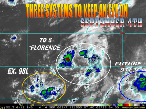
NWS Miami's thoughts on TD 6:
FXUS62 KMFL 040748
AFDMFL
AREA FORECAST DISCUSSION
NATIONAL WEATHER SERVICE MIAMI FL
348 AM EDT MON SEP 4 2006
GFS SHOWS A DEEPENING SURFACE LOW MOVING WEST TOWARD THE CENTRAL
BAHAMAS BY NEXT MONDAY. THIS SYSTEM IS THE ONE INITIALIZED AS THE
NEW T.D. # 6 NEAR 15N 40W. THE LONG RANGE GFS SHOWS THIS RECURVING
IN THE ATLANTIC AWAY FROM FLORIDA BUT IT STILL NEEDS TO BE WATCH
CAREFULLY SINCE THIS IS A LONG WAY OUT.
&&
T.D. Six - Sat Pics, Comments,Models Thread #2
Moderator: S2k Moderators
Forum rules

The posts in this forum are NOT official forecasts and should not be used as such. They are just the opinion of the poster and may or may not be backed by sound meteorological data. They are NOT endorsed by any professional institution or STORM2K. For official information, please refer to products from the National Hurricane Center and National Weather Service.
jlauderdal wrote:miamicanes177 wrote:hopefully the north shift is the beginning of a trend. Kind of like what we saw with ernersto when the models keep shifting more and more east. We want this going north and out to sea.
hebert box, based on the forecast this system misses hebert
If Floridians want an indication of a possible hit they need to keep an eye on any hurricane that passes through these boxes. Nearly every major Hurricane that hit S Florida since 1900 passed through these boxes. When major Hurricanes miss these boxes,they virtually always miss South Florida. If a major Hurricane moves into these boxes South Florida really needs to watch out. These boxes approx 335 miles x 335 miles includes the Virgin Islands but not Puerto Rico. The pattern has proven accurate for 9 out of 10 storms storms that developed & hit Dade,Broward & Palm Bch Counties. The following is a list showing Hurricanes that passed through these Boxes,starting with Box #1.
Jlauderdal, you forgot to add the list
0 likes
-
cycloneye

- Admin

- Posts: 148758
- Age: 69
- Joined: Thu Oct 10, 2002 10:54 am
- Location: San Juan, Puerto Rico
WHXX04 KWBC 041131
CHGQLM
ATTENTION...NATIONAL HURRICANE CENTER
NCEP COUPLED GFDL HURRICANE MODEL FORECAST MADE FOR
TROPICAL DEPRESSION SIX 06L
INITIAL TIME 6Z SEP 4
DISCLAIMER ... THIS INFORMATION IS PROVIDED AS GUIDANCE. IT
REQUIRES INTERPRETATION BY HURRICANE SPECIALISTS AND SHOULD
NOT BE CONSIDERED AS A FINAL PRODUCT. PLEASE SEE THE TPC/NHC
OFFICIAL FORECAST.
FORECAST STORM POSITION
HOUR LATITUDE LONGITUDE HEADING/SPEED(KT)
0 15.4 40.8 310./ 8.9
6 15.5 41.6 274./ 7.4
12 15.9 42.4 299./ 8.9
18 16.4 43.3 299./ 9.9
24 16.8 44.1 295./ 8.4
30 17.2 45.1 292./10.7
36 17.6 46.1 291./ 9.7
42 17.7 47.0 278./ 8.8
48 18.2 47.9 299./10.2
54 18.5 48.6 287./ 7.2
60 19.0 49.3 307./ 7.9
66 19.2 50.0 292./ 7.7
72 19.8 50.9 299./ 9.9
78 20.2 51.6 304./ 7.8
84 21.0 52.5 309./11.5
90 21.4 53.7 290./11.1
96 22.0 54.8 299./11.8
102 22.6 55.9 299./12.2
108 23.2 56.9 300./11.0
114 23.8 58.1 296./12.2
120 24.2 59.1 293./10.0
126 24.8 60.0 304./10.7
6z GFDL.
0 likes
Visit the Caribbean-Central America Weather Thread where you can find at first post web cams,radars
and observations from Caribbean basin members Click Here
and observations from Caribbean basin members Click Here

-
jlauderdal
- S2K Supporter

- Posts: 7240
- Joined: Wed May 19, 2004 5:46 am
- Location: NE Fort Lauderdale
- Contact:
TampaFl wrote:jlauderdal wrote:miamicanes177 wrote:hopefully the north shift is the beginning of a trend. Kind of like what we saw with ernersto when the models keep shifting more and more east. We want this going north and out to sea.
hebert box, based on the forecast this system misses hebert
If Floridians want an indication of a possible hit they need to keep an eye on any hurricane that passes through these boxes. Nearly every major Hurricane that hit S Florida since 1900 passed through these boxes. When major Hurricanes miss these boxes,they virtually always miss South Florida. If a major Hurricane moves into these boxes South Florida really needs to watch out. These boxes approx 335 miles x 335 miles includes the Virgin Islands but not Puerto Rico. The pattern has proven accurate for 9 out of 10 storms storms that developed & hit Dade,Broward & Palm Bch Counties. The following is a list showing Hurricanes that passed through these Boxes,starting with Box #1.
ok, here it is it took me a long time to type all this from my photographic memory.
Jlauderdal, you forgot to add the list
BOX #1 (since 1950)
1950 Baker--Alabama....1950 Dog--out to sea....1951 Charlie--Yucatan/Mexico....1952 Baker-- out to sea....1953 Carol--Nova scotia....1954 ALice--Leeward isl out to sea....1955 Connie--N Carolina....1955 Ione--N Carolina....1956 Betsy--N Antilles, PR,Bahamas....1958 Fifi--out to sea....1958 Ilsa--out to sea....1960 DonnaN Antilles,Bahamas,Fla,east seaboard....1963 Edith--windward isl,PR,Hispaniola....1964 Cleo--N Antilles,Hispaniola,Haiti,Cuba,Fla....1966 Faith--N Antilles....1966 Inez--N Antilles,Hispaniola,Haiti,Cuba,Bahamas,Fla,Yucatan,Mex....1967Beulah--Hispaniola,Yucata,S Texas....1975 Eloise--Hispaniola,Fla panhandle....1979 David--Antilles,Hispaniola,Haiti,Fla,Ga,Sc....1984 Klaus--out to sea....1985 Gloria--NE U.S....1989 dean--Bermuda,Newfoundland....1989 Hugo--N Antilles,PR,SC....1990 Klaus-- out to sea....1995 Luis--N Antilles,New foundland....1995 Marilyn--N antilles,VI.PR....1996 Bertha--N antilles,VI,PR,N carolina....1996 Fran--N Carolina....1996 Hortense--PR,Nova scotia....1997 Erika--out to sea....1998 Georges--N antilles,VI,PR,Hispaniola,Haiti,Cuba,Keys,mississippi....1999 Jose--N antilles,VI....1999 Lenny--N antilles....2000 Debby--n antilles,VI,Hispaniola....2004 FrancesBahamas,Treasure coast,Fla....
BOX #2 (since 1950)
1951 Item Cayman isl,Cuba....1952 FoxCaymans,Cuba,Bahamas....1961 HattieBelize....1981 KatrinaCuba,Bahamas....1988 GilbertYucatan,mexico....1995 RoxanneYucatan....1998 MitchHonduras....2001 irisBelize....2001 MichelleCuba,Bahamas....2004 Charley W cuba,Fla....2005 EmilyYucatan,Mexico....2005 WilmaYucatan,S Fla....
So what does all this mean when a Hurricane passes or develops in the Hebert Box east of Puerto Rico since 1950?
1)N Carolina has as much chance to get hit as Florida.
2)20.58% or most go out to sea without hitting land.
3)Only 8.82% make it into the Gulf of Mexico when they pass through the box as a hurricane.
4)Puerto Rico will get hit 20.58% of the time (the highest outside of n Antilles).
What about Box #2,Hurricanes developing or moving through after Oct 1st since 1950?
Cuba & the Bahamas are at highest risk late in the season.
To wrap things up, two significant Hurricanes that hit South Fla did not pass through this box, Andrew 1992, and Betsy 1965!. Data may be slightly off because these boxes were based on data going back to 1900. We chose names storms since 1950 for recognition purposes.
0 likes

Forcast rack is almost 5 degrees above the corner of the Hebert box and with a slower forward motion. Good news. The curve back towards the WNW near the end of the forcast does seem to indicate the current trough will miss but at 25N only a very strong persistent ridge would steer a storm west to the coast.
If the ULL over the midwest sinks southeast it should generate at least a short wave in time to help.
If the ULL over the midwest sinks southeast it should generate at least a short wave in time to help.
0 likes
-
StormWarning1
- Category 1

- Posts: 254
- Joined: Sun Jul 10, 2005 9:29 pm
- Location: Nashville TN
This look very pathetic on visible loops I just ran on the NASA site.
Looks like a small vortex at 16N 42W moves North and dissapates and the mid level center has been sheared off to the Northeast. I doubt this is even a tropical depression anymore.
NHC will probably let this run another advisory cycle or two but no improvement later today and it is back to a wave.
Blame shear.
0 likes
-
cycloneye
- Admin
- Posts: 148758
- Age: 69
- Joined: Thu Oct 10, 2002 10:54 am
- Location: San Juan, Puerto Rico
TROPICAL DEPRESSION SIX (AL062006) ON 20060904 1200 UTC
...00 HRS... ...12 HRS... ...24 HRS... ...36 HRS...
060904 1200 060905 0000 060905 1200 060906 0000
LAT LON LAT LON LAT LON LAT LON
BAMD 16.0N 42.3W 17.2N 43.9W 18.1N 45.5W 19.0N 47.1W
BAMM 16.0N 42.3W 17.2N 44.2W 18.1N 46.2W 18.7N 48.0W
A98E 16.0N 42.3W 17.1N 44.1W 18.3N 45.8W 19.7N 47.5W
LBAR 16.0N 42.3W 17.5N 43.8W 18.9N 45.3W 20.3N 46.9W
SHIP 30KTS 34KTS 38KTS 44KTS
DSHP 30KTS 34KTS 38KTS 44KTS
...48 HRS... ...72 HRS... ...96 HRS... ..120 HRS...
060906 1200 060907 1200 060908 1200 060909 1200
LAT LON LAT LON LAT LON LAT LON
BAMD 19.8N 48.8W 21.0N 52.7W 21.8N 56.8W 22.9N 60.8W
BAMM 18.9N 50.0W 18.9N 53.8W 19.1N 56.7W 20.1N 58.9W
A98E 20.7N 49.8W 23.6N 55.2W 25.6N 61.6W 26.9N 67.0W
LBAR 21.7N 48.7W 24.6N 53.1W 26.9N 58.3W 28.8N 63.0W
SHIP 48KTS 58KTS 65KTS 72KTS
DSHP 48KTS 58KTS 65KTS 72KTS
...INITIAL CONDITIONS...
LATCUR = 16.0N LONCUR = 42.3W DIRCUR = 305DEG SPDCUR = 10KT
LATM12 = 14.7N LONM12 = 40.6W DIRM12 = 309DEG SPDM12 = 10KT
LATM24 = 13.4N LONM24 = 38.7W
WNDCUR = 30KT RMAXWD = 60NM WNDM12 = 30KT
CENPRS = 1005MB OUTPRS = 1009MB OUTRAD = 175NM SDEPTH = D
RD34NE = 0NM RD34SE = 0NM RD34SW = 0NM RD34NW = 0NM
12:00z BAM Models.
0 likes
Visit the Caribbean-Central America Weather Thread where you can find at first post web cams,radars
and observations from Caribbean basin members Click Here
and observations from Caribbean basin members Click Here
-
Bailey1777
- S2K Supporter
- Posts: 962
- Joined: Mon Jul 31, 2006 6:23 pm
- Location: Houston, Texas
-
HurricaneMaster_PR

- Category 2

- Posts: 795
- Joined: Tue Jul 22, 2003 6:23 pm
- Location: San Juan, Puerto Rico
-
jusforsean

- Category 1
- Posts: 395
- Joined: Wed Nov 09, 2005 8:22 am
- Location: South Florida


tgenius wrote:HurricaneMaster_PR wrote:DATE/TIME LAT LON CLASSIFICATION STORM
04/1145 UTC 16.2N 42.2W T2.5/2.5 06L
That may be the case with the Dvorak reading, but IR (and I imagine Visable too) paint a diff picture, plus isn't that reading a few hours old already?
Those numbers have remained the same since yesterday evening. TPC has been estimating the intensity lower than that.
0 likes
-
wzrgirl1

- S2K Supporter
- Posts: 1360
- Joined: Sat Sep 04, 2004 6:44 am
- Location: Pembroke Pines, Florida
jlauderdal wrote:TampaFl wrote:jlauderdal wrote:miamicanes177 wrote:hopefully the north shift is the beginning of a trend. Kind of like what we saw with ernersto when the models keep shifting more and more east. We want this going north and out to sea.
hebert box, based on the forecast this system misses hebert
If Floridians want an indication of a possible hit they need to keep an eye on any hurricane that passes through these boxes. Nearly every major Hurricane that hit S Florida since 1900 passed through these boxes. When major Hurricanes miss these boxes,they virtually always miss South Florida. If a major Hurricane moves into these boxes South Florida really needs to watch out. These boxes approx 335 miles x 335 miles includes the Virgin Islands but not Puerto Rico. The pattern has proven accurate for 9 out of 10 storms storms that developed & hit Dade,Broward & Palm Bch Counties. The following is a list showing Hurricanes that passed through these Boxes,starting with Box #1.
ok, here it is it took me a long time to type all this from my photographic memory.
Jlauderdal, you forgot to add the list
BOX #1 (since 1950)
1950 Baker--Alabama....1950 Dog--out to sea....1951 Charlie--Yucatan/Mexico....1952 Baker-- out to sea....1953 Carol--Nova scotia....1954 ALice--Leeward isl out to sea....1955 Connie--N Carolina....1955 Ione--N Carolina....1956 Betsy--N Antilles, PR,Bahamas....1958 Fifi--out to sea....1958 Ilsa--out to sea....1960 DonnaN Antilles,Bahamas,Fla,east seaboard....1963 Edith--windward isl,PR,Hispaniola....1964 Cleo--N Antilles,Hispaniola,Haiti,Cuba,Fla....1966 Faith--N Antilles....1966 Inez--N Antilles,Hispaniola,Haiti,Cuba,Bahamas,Fla,Yucatan,Mex....1967Beulah--Hispaniola,Yucata,S Texas....1975 Eloise--Hispaniola,Fla panhandle....1979 David--Antilles,Hispaniola,Haiti,Fla,Ga,Sc....1984 Klaus--out to sea....1985 Gloria--NE U.S....1989 dean--Bermuda,Newfoundland....1989 Hugo--N Antilles,PR,SC....1990 Klaus-- out to sea....1995 Luis--N Antilles,New foundland....1995 Marilyn--N antilles,VI.PR....1996 Bertha--N antilles,VI,PR,N carolina....1996 Fran--N Carolina....1996 Hortense--PR,Nova scotia....1997 Erika--out to sea....1998 Georges--N antilles,VI,PR,Hispaniola,Haiti,Cuba,Keys,mississippi....1999 Jose--N antilles,VI....1999 Lenny--N antilles....2000 Debby--n antilles,VI,Hispaniola....2004 FrancesBahamas,Treasure coast,Fla....
BOX #2 (since 1950)
1951 Item Cayman isl,Cuba....1952 FoxCaymans,Cuba,Bahamas....1961 HattieBelize....1981 KatrinaCuba,Bahamas....1988 GilbertYucatan,mexico....1995 RoxanneYucatan....1998 MitchHonduras....2001 irisBelize....2001 MichelleCuba,Bahamas....2004 Charley W cuba,Fla....2005 EmilyYucatan,Mexico....2005 WilmaYucatan,S Fla....
So what does all this mean when a Hurricane passes or develops in the Hebert Box east of Puerto Rico since 1950?
1)N Carolina has as much chance to get hit as Florida.
2)20.58% or most go out to sea without hitting land.
3)Only 8.82% make it into the Gulf of Mexico when they pass through the box as a hurricane.
4)Puerto Rico will get hit 20.58% of the time (the highest outside of n Antilles).
What about Box #2,Hurricanes developing or moving through after Oct 1st since 1950?
Cuba & the Bahamas are at highest risk late in the season.
To wrap things up, two significant Hurricanes that hit South Fla did not pass through this box, Andrew 1992, and Betsy 1965!. Data may be slightly off because these boxes were based on data going back to 1900. We chose names storms since 1950 for recognition purposes.
please give the author credit on this....it came from hurricanecity.com
0 likes
Thunder44 wrote:tgenius wrote:HurricaneMaster_PR wrote:DATE/TIME LAT LON CLASSIFICATION STORM
04/1145 UTC 16.2N 42.2W T2.5/2.5 06L
That may be the case with the Dvorak reading, but IR (and I imagine Visable too) paint a diff picture, plus isn't that reading a few hours old already?
Those numbers have remained the same since yesterday evening. TPC has been estimating the intensity lower than that.
Ok, my bad then, I just thought they were old T #s as the Sat Imagery didn't look that hot this AM.
0 likes


-
HurricaneHunter914
- Category 5

- Posts: 4439
- Age: 32
- Joined: Fri Mar 10, 2006 7:36 pm
- Location: College Station, TX
When I saw TD#6 today I thought it had split into two waves of convection, but apparently its still a TD. As the trought lifts out conditions should become more favorable for strengthening along with a turn towards the WNW as the high builds in.
0 likes
Personal Forecast Disclaimer:
The posts in this forum are NOT official forecast and should not be used as such. They are just the opinion of the poster and may or may not be backed by sound meteorological data. They are NOT endorsed by any professional institution or storm2k.org. For official information, please refer to the NHC and NWS products.
The posts in this forum are NOT official forecast and should not be used as such. They are just the opinion of the poster and may or may not be backed by sound meteorological data. They are NOT endorsed by any professional institution or storm2k.org. For official information, please refer to the NHC and NWS products.
Who is online
Users browsing this forum: No registered users and 35 guests