Tropical Storm Helene,Analysis,Sat Pics,Models Thread #3

This is the general tropical discussion area. Anyone can take their shot at predicting a storms path.

Moderator: S2k Moderators

Forum rules

The posts in this forum are NOT official forecasts and should not be used as such. They are just the opinion of the poster and may or may not be backed by sound meteorological data. They are NOT endorsed by any professional institution or STORM2K. For official information, please refer to products from the National Hurricane Center and National Weather Service.

Help Support Storm2K
Message
Author
MiamiensisWx

#201 Postby MiamiensisWx » Wed Sep 20, 2006 9:55 am

marcane_1973 wrote:Her inner core looks ragged again this morning. Looks like Helene has hit her peak and is starting the northern turn taking her out to sea. Gordon was such a better looking Hurricane at his peak with a perfect cleared out eye and that buzzsaw look. :lol: Farewell Helene and good riddance. You sure were a bore to look at and plot. :roll: Now lets see if we can get a more interesting storm closer to home in the next couple of weeks.


Keep it in perspective. Look at 1983's and 1997's activity in the Atlantic. In fact, both of those years had just one major hurricane and fewer than ten named storms.

If this year was like 1983 or 1997, this board might be nearly out of business for some periods.

You are really pushing my temper over the edge.
0 likes   

User avatar
terstorm1012
S2K Supporter
S2K Supporter
Posts: 1314
Age: 43
Joined: Fri Sep 10, 2004 5:36 pm
Location: Millersburg, PA

#202 Postby terstorm1012 » Wed Sep 20, 2006 11:26 am

Helene was one of the more interesting storms to track...especially watching the numerical models swing back and forth before they matched up with what the synoptics were trying to say all along.

Great fun IMO.
0 likes   

User avatar
Nimbus
Category 5
Category 5
Posts: 5343
Joined: Mon Jul 19, 2004 10:54 am

#203 Postby Nimbus » Wed Sep 20, 2006 1:15 pm

Actually I would prefer to see her a few degrees further north in a hurry to recurve. Almost looks like ridging out in front of that trough could cause her to dilly dally around and delay the forecast the way Gordon did.
0 likes   

User avatar
SouthFloridawx
S2K Supporter
S2K Supporter
Posts: 8346
Age: 46
Joined: Tue Jul 26, 2005 1:16 am
Location: Sarasota, FL
Contact:

#204 Postby SouthFloridawx » Wed Sep 20, 2006 1:17 pm

marcane_1973 wrote:Her inner core looks ragged again this morning. Looks like Helene has hit her peak and is starting the northern turn taking her out to sea. Gordon was such a better looking Hurricane at his peak with a perfect cleared out eye and that buzzsaw look. :lol: Farewell Helene and good riddance. You sure were a bore to look at and plot. :roll: Now lets see if we can get a more interesting storm closer to home in the next couple of weeks.


Are you freaking serious? :roll:
Why would you want one closer to home?
This season has been turning out just fine with all the fish.
0 likes   

curtadams
S2K Supporter
S2K Supporter
Posts: 1122
Joined: Sun Aug 28, 2005 7:57 pm
Location: Orange, California
Contact:

#205 Postby curtadams » Wed Sep 20, 2006 1:37 pm

Just ignore comments like the last one by Marcane. You're not going to change his mind and the hurricanes don't give a toot what he thinks.
0 likes   

tgenius
S2K Supporter
S2K Supporter
Posts: 1160
Joined: Mon May 15, 2006 5:31 pm
Location: Miami, FL

#206 Postby tgenius » Wed Sep 20, 2006 1:39 pm

Camp "B" people in the house!! :lol:
0 likes   

User avatar
gatorcane
S2K Supporter
S2K Supporter
Posts: 23693
Age: 47
Joined: Sun Mar 13, 2005 3:54 pm
Location: Boca Raton, FL

#207 Postby gatorcane » Wed Sep 20, 2006 8:24 pm

it doesn't appear Helene is moving very much this evening....
0 likes   

User avatar
SouthFloridawx
S2K Supporter
S2K Supporter
Posts: 8346
Age: 46
Joined: Tue Jul 26, 2005 1:16 am
Location: Sarasota, FL
Contact:

#208 Postby SouthFloridawx » Wed Sep 20, 2006 8:35 pm

Image


Looks to be moving right along to me.
http://www.ssd.noaa.gov/goes/flt/t3/loop-rb.html
0 likes   

User avatar
MGC
S2K Supporter
S2K Supporter
Posts: 5905
Joined: Sun Mar 23, 2003 9:05 pm
Location: Pass Christian MS, or what is left.

#209 Postby MGC » Wed Sep 20, 2006 11:28 pm

Helene looks to be becoming a little better organized this morning. Looks like an eye is about to become visible. 5am advisory might bump the winds up a notch. A few more days and Helene will be history.....MGC
0 likes   

User avatar
StrongWind
Tropical Storm
Tropical Storm
Posts: 240
Joined: Tue Aug 31, 2004 5:02 pm
Location: Deerfield Beach, FL

#210 Postby StrongWind » Wed Sep 20, 2006 11:37 pm

A couple of questions if ya'll don't mind:

The trough that is now affecting Helene eased up and slowed before getting this far east. What would happen if a huge trough like this was earlier slammed full speed into a cat 3+ hurricane? Would the 'cane just go poff? Would the leading edge over-shoot the core leaving the 'cane to wallow around?

There also looks like a high barreling eastward across the SE US. Will it weaken the trough when it gets to it in the next day or so?

Thanks.
0 likes   

User avatar
wxmann_91
Category 5
Category 5
Posts: 8013
Age: 34
Joined: Fri Jul 15, 2005 2:49 pm
Location: Southern California
Contact:

#211 Postby wxmann_91 » Wed Sep 20, 2006 11:59 pm

StrongWind wrote:A couple of questions if ya'll don't mind:

The trough that is now affecting Helene eased up and slowed before getting this far east. What would happen if a huge trough like this was earlier slammed full speed into a cat 3+ hurricane? Would the 'cane just go poff? Would the leading edge over-shoot the core leaving the 'cane to wallow around?

There also looks like a high barreling eastward across the SE US. Will it weaken the trough when it gets to it in the next day or so?

Thanks.


1) If a huge trough slammed full-speed into a major hurricane, the major hurricane would die and get deflected northward. On the other hand, a weaker trough that goes north, that's when the recurvature vs. bend back west thing gets tough.

2) The high barreling toward the SE U.S. is part of the trough that is steering Helene. Remember: ridges follow troughs (think of troughs and ridges as sinusoidal waves) and the general mid-latitude flow from east to west allow troughs to weaken ridges to the east while a ridge builds in behind a trough. Ridges don't weaken troughs usually if they are building in behind one.
0 likes   

User avatar
Meso
Category 5
Category 5
Posts: 1609
Age: 38
Joined: Mon Aug 09, 2004 12:14 pm
Location: South Africa
Contact:

#212 Postby Meso » Thu Sep 21, 2006 11:51 am

haha, lol @ the bams http://www.sfwmd.gov/org/omd/ops/weathe ... orm_08.gif

Obviously not, but imagine that were to happen,wonder where it would make landfall.
0 likes   

User avatar
gatorcane
S2K Supporter
S2K Supporter
Posts: 23693
Age: 47
Joined: Sun Mar 13, 2005 3:54 pm
Location: Boca Raton, FL

#213 Postby gatorcane » Thu Sep 21, 2006 11:53 am

Meso wrote:haha, lol @ the bams http://www.sfwmd.gov/org/omd/ops/weathe ... orm_08.gif

Obviously not, but imagine that were to happen,wonder where it would make landfall.


Maybe it will make landfall in the Cape Verde Islands and go full circle :eek:
0 likes   

User avatar
Thunder44
Category 5
Category 5
Posts: 5922
Age: 44
Joined: Mon Jun 09, 2003 7:53 pm
Location: New York City

#214 Postby Thunder44 » Thu Sep 21, 2006 11:55 am

gatorcane wrote:
Meso wrote:haha, lol @ the bams http://www.sfwmd.gov/org/omd/ops/weathe ... orm_08.gif

Obviously not, but imagine that were to happen,wonder where it would make landfall.


Maybe it will make landfall in the Cape Verde Islands and go full circle :eek:


The ECMWF last night actually showed Helene going that direction. I don't believe it though.
Last edited by Thunder44 on Thu Sep 21, 2006 12:54 pm, edited 2 times in total.
0 likes   

User avatar
storms in NC
S2K Supporter
S2K Supporter
Posts: 2338
Joined: Thu Jul 28, 2005 2:58 pm
Location: Wallace,NC 40 miles NE of Wilm
Contact:

#215 Postby storms in NC » Thu Sep 21, 2006 12:32 pm

You all would crap LOL :lol:
0 likes   

User avatar
Thunder44
Category 5
Category 5
Posts: 5922
Age: 44
Joined: Mon Jun 09, 2003 7:53 pm
Location: New York City

#216 Postby Thunder44 » Thu Sep 21, 2006 12:54 pm

Thunder44 wrote:
gatorcane wrote:
Meso wrote:haha, lol @ the bams http://www.sfwmd.gov/org/omd/ops/weathe ... orm_08.gif

Obviously not, but imagine that were to happen,wonder where it would make landfall.


Maybe it will make landfall in the Cape Verde Islands and go full circle :eek:


The ECMWF last night actually showed Helene going that direction. I don't believe it though.


Now look at who joins the fun. The 12z UKMET :lol: :

http://moe.met.fsu.edu/cgi-bin/ukmtc2.c ... =Animation
0 likes   

User avatar
fci
S2K Supporter
S2K Supporter
Posts: 3324
Joined: Tue Sep 14, 2004 10:29 am
Location: Lake Worth, FL

#217 Postby fci » Thu Sep 21, 2006 12:57 pm

Thunder44 wrote:Now look at who joins the fun. The 12z UKMET :lol: :

http://moe.met.fsu.edu/cgi-bin/ukmtc2.c ... =Animation


That would sure not bode well for the Azores either.
0 likes   

Thatsmrhurricane
Tropical Storm
Tropical Storm
Posts: 182
Joined: Fri Jun 09, 2006 5:30 pm
Location: CBNC

#218 Postby Thatsmrhurricane » Thu Sep 21, 2006 1:28 pm

Not to mention, that it would be one of the coolest things I've ever seen.

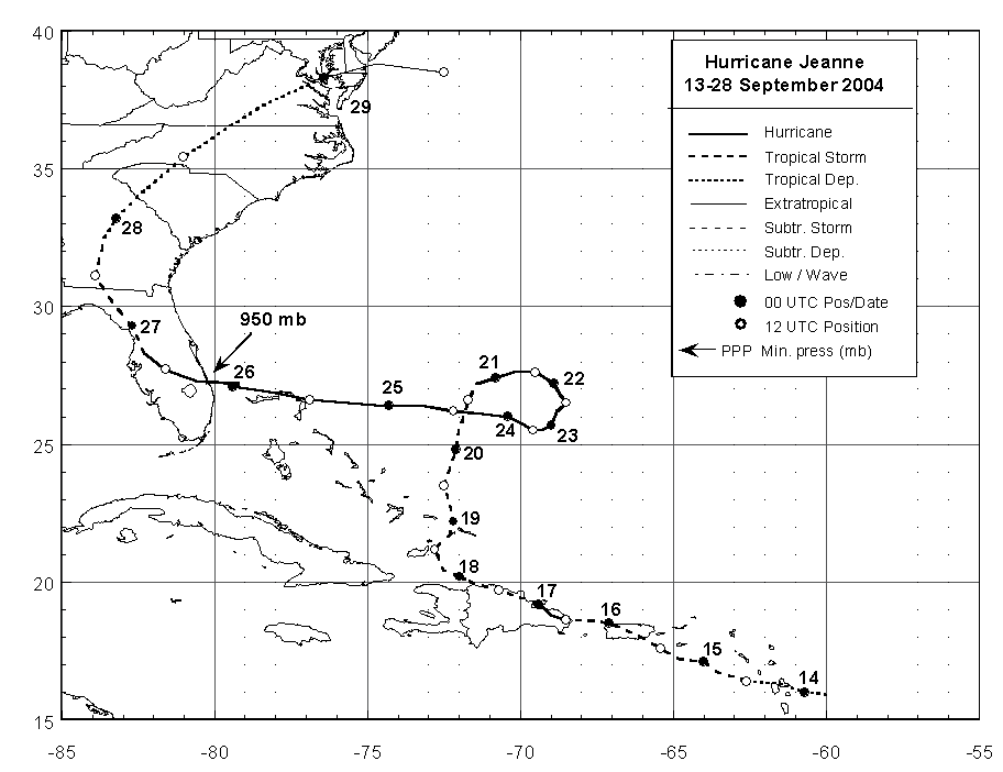
Off topic: Has that ever happened before? Besides Ivan doing it off the EC, has a hurricane ever looped this much and then tracked back over the Atlantic W?

Can you imagine if the I storm were to form and the H storm follows?

I could not find one that did this.
0 likes   

User avatar
artist
Category 5
Category 5
Posts: 9792
Joined: Mon Jun 06, 2005 3:26 pm
Location: West Palm

#219 Postby artist » Thu Sep 21, 2006 1:37 pm

Jeanne didn't travel that far north but she made a couple of loops.

Image
0 likes   

hcane27
Tropical Storm
Tropical Storm
Posts: 231
Joined: Tue Jan 31, 2006 7:33 pm

The closest example I can find

#220 Postby hcane27 » Thu Sep 21, 2006 2:19 pm

Image
0 likes   


Return to “Talkin' Tropics”

Who is online

Users browsing this forum: Blown Away, facemane, Frank P, Google [Bot], Google Adsense [Bot], hurricane2025, islandgirl45, JtSmarts, Kazmit, KeysRedWine, Lizzytiz1, prairie2, riapal, SFLcane, sunny and 93 guests