WPAC - Xangsane - ~200 deaths in the Philippines

This is the general tropical discussion area. Anyone can take their shot at predicting a storms path.

Moderator: S2k Moderators

Forum rules

The posts in this forum are NOT official forecasts and should not be used as such. They are just the opinion of the poster and may or may not be backed by sound meteorological data. They are NOT endorsed by any professional institution or STORM2K. For official information, please refer to products from the National Hurricane Center and National Weather Service.

Help Support Storm2K
Message
Author
User avatar
HURAKAN
Professional-Met
Professional-Met
Posts: 46086
Age: 38
Joined: Thu May 20, 2004 4:34 pm
Location: Key West, FL
Contact:

#41 Postby HURAKAN » Wed Sep 27, 2006 9:01 am

Image

75 knots that far inland??? I will believe it when I see it!!!! :lol: :lol: :lol:
0 likes   

User avatar
HURAKAN
Professional-Met
Professional-Met
Posts: 46086
Age: 38
Joined: Thu May 20, 2004 4:34 pm
Location: Key West, FL
Contact:

#42 Postby HURAKAN » Wed Sep 27, 2006 9:19 am

Image

Nice little eye before landfall.
0 likes   

User avatar
Aslkahuna
Professional-Met
Professional-Met
Posts: 4550
Joined: Thu Feb 06, 2003 5:00 pm
Location: Tucson, AZ
Contact:

#43 Postby Aslkahuna » Wed Sep 27, 2006 4:59 pm

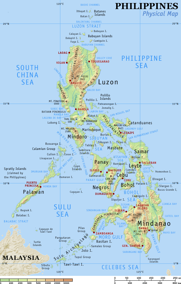
Storms that run up the Bicol like that lose intensity slower than they would if the punched across the mountains along the east coast of Luzon further north since the terrain is not as rugged and goodly portions of the storm stay out over water until we get into the Tagalog region south of Manila (and at that there's a very large lake-Laguna de Bay SE of Manila similar to a lake behind NOLA-and like NOLA portions of Manila are below sea level). In 1995, Angela made landfall at Daet north of Legaspi and still had 80kt sustained winds over Manila.

Steve
0 likes   

User avatar
wxmann_91
Category 5
Category 5
Posts: 8013
Age: 34
Joined: Fri Jul 15, 2005 2:49 pm
Location: Southern California
Contact:

#44 Postby wxmann_91 » Wed Sep 27, 2006 5:13 pm

Steve is right

Image

Interesting how it rapidly strengthened while it was along the coast yesterday and is still maintaining an eye even though it has been intermittently on land for the past 12 hours.

Thanks for the info about Manila, Steve. I had not known about that. That's pretty much setting up for catastrophe. BTW, a bit OT, but happy birthday! :)
0 likes   

User avatar
Aslkahuna
Professional-Met
Professional-Met
Posts: 4550
Joined: Thu Feb 06, 2003 5:00 pm
Location: Tucson, AZ
Contact:

#45 Postby Aslkahuna » Wed Sep 27, 2006 7:04 pm

A lot of the intensifcation took place while the storm was transitting the San Bernardino Strait. Based upon the reports from Legaspi, the core was very tightly wound up and the strongest winds probably reamined overwater. Manila WILL flood because like certain places here in the US they flood if you so much as say the word RAIN.

Steve
0 likes   

User avatar
wxmann_91
Category 5
Category 5
Posts: 8013
Age: 34
Joined: Fri Jul 15, 2005 2:49 pm
Location: Southern California
Contact:

#46 Postby wxmann_91 » Wed Sep 27, 2006 7:13 pm

Are there any radars from the Philippines or Vietnam?
0 likes   

dwsqos2

#47 Postby dwsqos2 » Wed Sep 27, 2006 11:20 pm

RPLL 280400Z 06052G77KT 1000 -RA SCT018 OVC090 24/24 Q9986 RMK A2912

Granted, Manila has experienced worse; however, it is a notable observation.
0 likes   

User avatar
Aslkahuna
Professional-Met
Professional-Met
Posts: 4550
Joined: Thu Feb 06, 2003 5:00 pm
Location: Tucson, AZ
Contact:

#48 Postby Aslkahuna » Thu Sep 28, 2006 12:03 am

Record wind gusts for Manila were recorded with STY Angela in 1995 at 105kt.

Steve
0 likes   

HurricaneBill
Category 5
Category 5
Posts: 3420
Joined: Sun Apr 11, 2004 5:51 pm
Location: East Longmeadow, MA, USA

#49 Postby HurricaneBill » Thu Sep 28, 2006 12:17 am

Hopefully, another typhoon won't follow Xangsane into the Philippines.
0 likes   

User avatar
Aslkahuna
Professional-Met
Professional-Met
Posts: 4550
Joined: Thu Feb 06, 2003 5:00 pm
Location: Tucson, AZ
Contact:

#50 Postby Aslkahuna » Thu Sep 28, 2006 12:59 am

Actually double whammies like that are not uncommon in the Philippines. Manila actually doesn't get hit directly that often and this storm is probably the strongest to hit since Angela in 1995.
0 likes   

User avatar
Aslkahuna
Professional-Met
Professional-Met
Posts: 4550
Joined: Thu Feb 06, 2003 5:00 pm
Location: Tucson, AZ
Contact:

#51 Postby Aslkahuna » Thu Sep 28, 2006 1:29 am

O600Z: Manila reporting 20 mph winds from the SSE and 954 hPa.

Steve
0 likes   

User avatar
Yarrah
Category 2
Category 2
Posts: 658
Joined: Tue Feb 07, 2006 6:15 pm
Location: Utrecht, The Netherlands
Contact:

#52 Postby Yarrah » Thu Sep 28, 2006 2:33 am

6 people have been killed, according to NOS. More casualties are expected as it moves further to the west.
0 likes   

User avatar
P.K.
Professional-Met
Professional-Met
Posts: 5149
Joined: Thu Sep 23, 2004 5:57 pm
Location: Watford, England
Contact:

#53 Postby P.K. » Thu Sep 28, 2006 4:00 am

Aslkahuna wrote:O600Z: Manila reporting 20 mph winds from the SSE and 954 hPa.


I'm not sure about that METAR. They are reporting the pressure in both conventional and old methods. It looks to match up apart from the 0600 GMT METAR which converting the old method would give 995hPa. Also at that time I make the centre 65km to the WNW based on the advisory so I think the 995hPa value is more likely. Also I see the pressure at Subic Bay has not dropped below 989hPa up to 0800 GMT.

RSMC TROPICAL CYCLONE ADVISORY
NAME TY 0615 XANGSANE (0615)
ANALYSIS
PSTN 280600UTC 14.6N 120.4E GOOD
MOVE WNW 14KT
PRES 975HPA
MXWD 065KT
50KT 50NM
30KT 130NM
FORECAST
24HF 290600UTC 15.3N 115.4E 80NM 70%
MOVE W 12KT
PRES 960HPA
MXWD 075KT
48HF 300600UTC 15.9N 111.4E 150NM 70%
MOVE W 09KT
PRES 955HPA
MXWD 080KT
72HF 010600UTC 16.2N 107.5E 220NM 70%
MOVE W 09KT
PRES 985HPA
MXWD 050KT
0 likes   

User avatar
Aslkahuna
Professional-Met
Professional-Met
Posts: 4550
Joined: Thu Feb 06, 2003 5:00 pm
Location: Tucson, AZ
Contact:

#54 Postby Aslkahuna » Thu Sep 28, 2006 4:43 am

The center is clearly reforming NW of Subic which is now reporting SW winds of 56G78mph. Clark had sustained winds in the 40 mph range so it looks like my expected 45-50 kt gusts worked out well for that area. Iba, due west of Clark on the coast and on the other side of the Zambales Mountains, hasn't picked up in wind speed yet and won't until the winds shift SW from off the water. Subic got some funneling through the Pass earlier but they always get blasted with SW winds. The emphasis will now shift to the winds and rain along te west coast of Luzon and the areas of Bataan, Zambales and western Pampanga Provinces. A state of Calamity has been declared in Manila. JT has held the storm as a typhoon throughout the transit of Luzon but PAGASA dropped it to a TS as the storm moved through Manila with 110 km/hr winds

Steve
0 likes   

User avatar
HURAKAN
Professional-Met
Professional-Met
Posts: 46086
Age: 38
Joined: Thu May 20, 2004 4:34 pm
Location: Key West, FL
Contact:

#55 Postby HURAKAN » Thu Sep 28, 2006 6:02 am

XANGSANE, 2000:
Image

XANGSANE, 2006:
Image

Xangsane, 2 for 2 on the Philippines. Also to note, almost the same track through the islands nation.
0 likes   

User avatar
HURAKAN
Professional-Met
Professional-Met
Posts: 46086
Age: 38
Joined: Thu May 20, 2004 4:34 pm
Location: Key West, FL
Contact:

#56 Postby HURAKAN » Thu Sep 28, 2006 8:58 am

Typhoon Xangsane batters Philippines
Thursday, September 28, 2006 (Manila):

Typhoon Xangsane unleashed fierce winds and rains as it slammed into the northern and central Philippines on Thursday.

The typhoon killed at least seven people across the country and shut down the capital amid widespread floods and damage.

The Manila airport general manager suspended all flights around noon (0400 GMT) because of electric power cuts. The typhoon toppled trees and triggered landslides, blocking some provincial roads.

It also shut schools, ferries, the country's financial markets, and forced officials to suspend two commuter trains in metropolitan Manila.

In Manila, the winds ripped giant highway tarpaulin billboards and toppled a tree in front of the US Embassy, blocking traffic.

Passengers stuck

Some residents in flooded areas ferried people across streets under knee-deep water on makeshift rafts, charging about 20 pesos (0.40 US dollars) per person.

Passengers were seen waiting at Manila airport, not knowing when they will be able to depart.

"I've got a flight booked for 5:40 this afternoon but we haven't been told otherwise what's going to happen, all the flights are still cancelled so we're just going to sit here until they make a decision at four o'clock this afternoon," Tim Miller, a stranded Australian tourist said.

The typhoon packed maximum winds of 130 kilometres per hour and gusts of up to 160 kilometres per hour when it made landfall overnight in the central Bicol region, where it knocked out electricity in five provinces.

It weakened into a storm with 110 kilometres winds (69 miles) per hour but picked up speed as it passed over Manila. It was the strongest typhoon to directly hit Manila in 11 years.

In November 1995, the 260-kilometres per hour super typhoon Angela battered the Philippine capital after slicing through central provinces, leaving 936 people dead.(AP)


http://www.ndtv.com/morenews/showmorest ... s&id=93918
0 likes   

User avatar
HURAKAN
Professional-Met
Professional-Met
Posts: 46086
Age: 38
Joined: Thu May 20, 2004 4:34 pm
Location: Key West, FL
Contact:

#57 Postby HURAKAN » Thu Sep 28, 2006 10:34 am

T0615 (XANGSANE)
Issued at 12:00 UTC 28 Sep 2006

RSMC TROPICAL CYCLONE ADVISORY
NAME TY 0615 XANGSANE (0615)
ANALYSIS
PSTN 281200UTC 15.6N 119.1E GOOD
MOVE NW 16KT
PRES 965HPA
MXWD 075KT
50KT 60NM
30KT 130NM
FORECAST
24HF 291200UTC 16.1N 114.6E 80NM 70%
MOVE W 10KT
PRES 955HPA
MXWD 080KT
48HF 301200UTC 17.0N 111.2E 150NM 70%
MOVE W 08KT
PRES 955HPA
MXWD 080KT
72HF 011200UTC 17.0N 106.7E 220NM 70%
MOVE W 10KT
PRES 985HPA
MXWD 050KT

Image
0 likes   

HurricaneBill
Category 5
Category 5
Posts: 3420
Joined: Sun Apr 11, 2004 5:51 pm
Location: East Longmeadow, MA, USA

#58 Postby HurricaneBill » Thu Sep 28, 2006 1:44 pm

Steve, how serious is a state of Calamity?
0 likes   

User avatar
P.K.
Professional-Met
Professional-Met
Posts: 5149
Joined: Thu Sep 23, 2004 5:57 pm
Location: Watford, England
Contact:

#59 Postby P.K. » Thu Sep 28, 2006 5:29 pm

I know of at least one person heading to Vietnam at the weekend to intercept this.

RSMC TROPICAL CYCLONE ADVISORY
NAME TY 0615 XANGSANE (0615)
ANALYSIS
PSTN 282100UTC 15.3N 117.6E FAIR
MOVE W 10KT
PRES 955HPA
MXWD 080KT
50KT 75NM
30KT 150NM
FORECAST
24HF 292100UTC 15.9N 112.9E 80NM 70%
MOVE W 10KT
PRES 950HPA
MXWD 085KT
45HF 301800UTC 16.5N 110.7E 150NM 70%
MOVE W 07KT
PRES 950HPA
MXWD 085KT
69HF 011800UTC 16.1N 106.6E 220NM 70%
MOVE W 10KT
PRES 990HPA
MXWD 045KT
0 likes   

User avatar
Aslkahuna
Professional-Met
Professional-Met
Posts: 4550
Joined: Thu Feb 06, 2003 5:00 pm
Location: Tucson, AZ
Contact:

#60 Postby Aslkahuna » Thu Sep 28, 2006 6:38 pm

A State of Calamity is similar to a Disaster Declaration here in the US. By its declaration it automatically triggers the Government response and activates the National Disaster Coordination Board of which the President is Chair-though she had to chair the meeting via conference call from the Clark Special Economic Zone because she was stuck there when the strong winds hit Clark. Reports on the Inq7 site indicate 29 fatalities now overall with power out to much of Luzon. The storm was indeed the strongest to hit Manila since Angela in 1995.

Steve
0 likes   


Return to “Talkin' Tropics”

Who is online

Users browsing this forum: alan1961, AnnularCane, CFLHurricane, dexterlabio, TomballEd, wzrgirl1 and 53 guests