Hurricane Isaac - Cat. 1
Moderator: S2k Moderators
-
TheEuropean

- Professional-Met

- Posts: 1797
- Age: 60
- Joined: Tue Sep 20, 2005 3:17 pm
- Location: Voerde, Germany
- Contact:
-
Evil Jeremy

- S2K Supporter

- Posts: 5463
- Age: 32
- Joined: Mon Apr 10, 2006 2:10 pm
- Location: Los Angeles, CA
-
TheEuropean
- Professional-Met
- Posts: 1797
- Age: 60
- Joined: Tue Sep 20, 2005 3:17 pm
- Location: Voerde, Germany
- Contact:
-
TheEuropean
- Professional-Met
- Posts: 1797
- Age: 60
- Joined: Tue Sep 20, 2005 3:17 pm
- Location: Voerde, Germany
- Contact:
-
wxman57

- Moderator-Pro Met

- Posts: 23172
- Age: 68
- Joined: Sat Jun 21, 2003 8:06 pm
- Location: Houston, TX (southwest)
I see no reason to modify the intensity on the next advisory. Doesn't look any better than it did earlier today. Even short-term Dvorak estimates are 3.0 or less:
http://cimss.ssec.wisc.edu/tropic/adt/odt1.html
http://cimss.ssec.wisc.edu/tropic/adt/odt1.html
0 likes
-
cycloneye

- Admin

- Posts: 149275
- Age: 69
- Joined: Thu Oct 10, 2002 10:54 am
- Location: San Juan, Puerto Rico
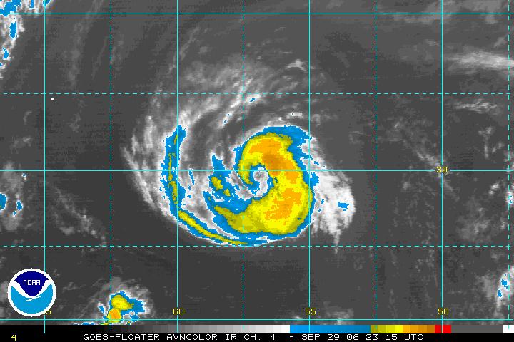
29/2345 UTC 29.9N 57.1W T3.5/3.5 ISAAC -- Atlantic Ocean
http://www.ssd.noaa.gov/PS/TROP/positions.html
Intensity chart below.
http://www.ssd.noaa.gov/PS/TROP/CI-chart.html
Almost a hurricane according to SSD dvorak sat estimates.
http://www.ssd.noaa.gov/PS/TROP/positions.html
Intensity chart below.
http://www.ssd.noaa.gov/PS/TROP/CI-chart.html
Almost a hurricane according to SSD dvorak sat estimates.
0 likes
Visit the Caribbean-Central America Weather Thread where you can find at first post web cams,radars
and observations from Caribbean basin members Click Here
and observations from Caribbean basin members Click Here


-
cycloneye
- Admin
- Posts: 149275
- Age: 69
- Joined: Thu Oct 10, 2002 10:54 am
- Location: San Juan, Puerto Rico
TROPICAL STORM ISAAC (AL092006) ON 20060930 0000 UTC
...00 HRS... ...12 HRS... ...24 HRS... ...36 HRS...
060930 0000 060930 1200 061001 0000 061001 1200
LAT LON LAT LON LAT LON LAT LON
BAMD 29.9N 57.1W 30.7N 58.5W 31.6N 59.8W 32.9N 60.8W
BAMM 29.9N 57.1W 30.6N 58.6W 31.5N 60.2W 32.7N 61.6W
A98E 29.9N 57.1W 30.5N 58.2W 31.5N 59.1W 33.1N 59.7W
LBAR 29.9N 57.1W 30.9N 58.3W 31.8N 58.7W 33.4N 59.2W
SHIP 60KTS 64KTS 65KTS 65KTS
DSHP 60KTS 64KTS 65KTS 65KTS
...48 HRS... ...72 HRS... ...96 HRS... ..120 HRS...
061002 0000 061003 0000 061004 0000 061005 0000
LAT LON LAT LON LAT LON LAT LON
BAMD 35.1N 61.5W 43.8N 59.0W 50.9N 48.5W 54.2N 28.4W
BAMM 34.8N 62.5W 42.6N 59.4W 49.2N 49.2W 51.2N 31.4W
A98E 35.7N 59.1W 45.7N 51.6W 52.2N 30.0W 37.0N 11.9W
LBAR 34.5N 60.1W 39.6N 56.8W 48.9N 39.7W .0N .0W
SHIP 68KTS 73KTS 67KTS 58KTS
DSHP 68KTS 73KTS 63KTS 54KTS
...INITIAL CONDITIONS...
LATCUR = 29.9N LONCUR = 57.1W DIRCUR = 300DEG SPDCUR = 6KT
LATM12 = 29.2N LONM12 = 55.9W DIRM12 = 298DEG SPDM12 = 6KT
LATM24 = 28.9N LONM24 = 54.9W
WNDCUR = 60KT RMAXWD = 35NM WNDM12 = 45KT
CENPRS = 995MB OUTPRS = 1017MB OUTRAD = 175NM SDEPTH = D
RD34NE = 100NM RD34SE = 90NM RD34SW = 60NM RD34NW = 60NM
0 likes
Visit the Caribbean-Central America Weather Thread where you can find at first post web cams,radars
and observations from Caribbean basin members Click Here
and observations from Caribbean basin members Click Here


-
HurricaneHunter914
- Category 5

- Posts: 4439
- Age: 32
- Joined: Fri Mar 10, 2006 7:36 pm
- Location: College Station, TX
Mr. Isaac really wants to be the 5th cane of the season.
0 likes
Personal Forecast Disclaimer:
The posts in this forum are NOT official forecast and should not be used as such. They are just the opinion of the poster and may or may not be backed by sound meteorological data. They are NOT endorsed by any professional institution or storm2k.org. For official information, please refer to the NHC and NWS products.
The posts in this forum are NOT official forecast and should not be used as such. They are just the opinion of the poster and may or may not be backed by sound meteorological data. They are NOT endorsed by any professional institution or storm2k.org. For official information, please refer to the NHC and NWS products.

-
LAwxrgal

- S2K Supporter
- Posts: 1763
- Joined: Tue Jul 06, 2004 1:05 pm
- Location: Reserve, LA (30 mi west of NOLA)
Very compact little thing... what is it about these storms that form up here in the open Atlantic that makes them so compact? Wilma's eye at one point was about as big as this thing is. 
0 likes
Andrew 92/Isidore & Lili 02/Bill 03/Katrina & Rita 05/Gustav & Ike 08/Isaac 12 (flooded my house)/Harvey 17/Barry 19/Cristobal 20/Claudette 21/Ida 21 (In the Eye)/Francine 24
Wake me up when November ends
Wake me up when November ends

Who is online
Users browsing this forum: No registered users and 29 guests