
The following post is NOT an official forecast and should not be used as such. It is just the opinion of the poster and may or may not be backed by sound meteorological data. It is NOT endorsed by any professional institution including storm2k.org For Official Information please refer to the NHC and NWS products.
The following is NOT even an actual storm.
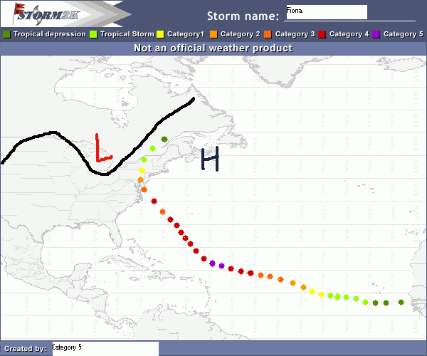
On September 2nd, Tropical Depression 6 formed literally only hours after emerging off the African coast. TD 6 got its act together and became Tropical Storm Fiona on September 3rd. Fiona strengthened slowly and eventually became a Hurricane on September 5th. Fiona continued strengthening, becoming a category two late on the 5th, a category three on the 6th, a category four on the 7th, then a category five early on the 8th. On September 8th, Fiona reached her peak intensity of 170mph and 907mb. Late on September 8th, Fiona weakened back to a category four.
A strong ridge had kept Fiona going west, as soon as it found a slightly weaker spot on September 8th, she turned toward the west-northwest and then the northwest overnight. It appeared that Fiona was heading out to sea. Then an unwelcomed guest crashed the fish party.
A misplaced Bermuda high raced in, setting up shop near Sable Island, this blocked Fiona from turning to the north, and sent it right toward the Mid Atlantic. Due to record warm SST’S, Fiona remained a category four through the 9th and 10th. Early on September 11th, Fiona weakened to a category three but found the Gulf Stream later on that day and regained category four strength. Fiona was downgraded to a category three only hours from landfall near Ocean City Maryland. It was the first major Hurricane on record to hit the state.
Fiona turned toward the North and accelerated due to being funneled by the ECT and the Bermuda High. She passed just west of Philadelphia as a category two Hurricane near midnight on the 13th. Fiona was downgraded to a tropical storm later that day and became extratropical early on the 14th.
-----------------------------
ZCZC MIATCPAT2 ALL
TTAA00 KNHC DDHHMM
BULLETIN
HURRICANE FIONA INTERMEDIATE ADVISORY NUMBER 55A
NWS TPC/NATIONAL HURRICANE CENTER MIAMI FL
2AM EDT SUN SEP 12 2010
...EXTREMELY DANGEROUS HURRICANE FIONA, MAKING LANDFALL NEAR OCEAN CITY MARYLAND...BECOMES THE FIRST MAJOR HURRICANE ON RECORD TO MAKE LANDFALL IN MARYLAND.
A HURRICANE WARNING IS IN EFFECT FROM NAGS HEAD NORTH CAROLINA NORTHWARD TO ROCKAWAY POINT NEW YORK. A HURRICANE WARNING MEANS THAT HURRICANE CONDITIONS ARE EXPECTED IN THE NEXT 24 HOURS.
A HURRICANE WATCH IS IN EFFECT FROM NAGS HEAD NORTH CAROLINA SOUTHWARD TO CAPE HARRERAS NORTH CAROLINA, AND FROM ROCKAWAY POINT NEW YORK EASTWARD TO MONTAUK NEW YORK. A HURRICANE WATCH MEANS THAT HURRICANE CONDITONS ARE POSSIBLE IN THE NEXT 36 HOURS.
A TROPICAL STORM WARNING IS IN EFFECT FROM NAGS HEAD NORTH CAROLINA SOUTHWARD TO CAPE LOOKOUT NORTH CAROLINA, AND FROM ROCKAWAY POINT NEW YORK EASTWARD TO CHATHAM MASSACHUSETTS, INCLUDING MARTHAS VINEYARD AND NANTUCKET. A TROPICAL STORM WARNING MEANS THAT TROPICAL STORM CONDITIONS ARE EXPECTED IN THE NEXT 24 HOURS.
AT 2AM...600Z, THE CENTER OF HURRICANE FIONA WAS LOCATED NEAR LATITUDE 38.4 NORTH, LONGITUDE 75.0 WEST, THIS POSITION IS RIGHT OVER OCEAN CITY MARYLAND.
FIONA IS MOVING TOWARD THE NORTHWEST AT 27 MPH, A TURN TOWARD THE NORTH AND AN INCREASE IN FOREWARD SPEED ARE EXPECTED IN THE NEXT 24 HOURS.
MAXIMUM SUSTAINED WINDS ARE NEAR 130 MPH...WITH HIGHER GUSTS. FIONA IS A STRONG CATEGORY 3 HURRICANE ON THE SAFFIR SIMPSON SCALE. WEAKENING IS FORECAST AS THE CENTER MOVES INLAND TODAY.
FIONA IS A VERY LARGE HURRICANE. HURRICANE FORCE WINDS EXTEND OUTWARD UP TO 175 MILES FROM THE CENTER...AND TROPICAL STORM FORCE WINDS EXTEND OUTWARD UP TO 395 MILES. RECENTLY, CAPE MAY NEW JERSEY REPORTED SUSTAINED WINDS OF 99 MPH WITH A GUST TO 127 MPH.
THE MINIMUM CENTRAL PRESSURE RECENTLY REPORTED BY AN AIR FORCE
RESERVE UNIT RECONNAISSANCE AIRCRAFT WAS 948 MB...27.99 INCHES.
COASTAL STORM SURGE FLOODING OF 18-21 FEET ABOVE NORMAL TIDE LEVELS...LOCALLY AS HIGH AS 25 FEET...ALONG WITH LARGE AND DANGEROUS BATTERING WAVES...CAN BE EXPECTED NEAR AND NORTH OF WHERE THE CENTER MAKES LANDFALL.
RAINFALL TOTALS OF 9 TO 12 INCHES...WITH ISOLATED MAXIMUM AMOUNTS OF 18 INCHES...ARE POSSIBLE ALONG THE PATH OF FIONA.
REPEATING THE 2 AM EDT POSITION...38.4 N...75.0 W. MOVEMENT TOWARD...NORTHWEST AT 27 MPH. MAXIMUM SUSTAINED WINDS...130 MPH. MINIMUM CENTRAL PRESSURE... 948 MB.
THE NEXT ADVISORY WILL BE ISSUED BY THE HURRICANE CENTER AT 5AM EDT.
FORCASTER FAKE
Thanks to wxmann_91 for the photoshop


