http://www.nco.ncep.noaa.gov/pmb/nwprod ... _192.shtml
Bbbrrrrrrrr......

Moderator: S2k Moderators


yes, I just noticed that from the CPC as well.Portastorm wrote:In addition to JB, some of the pro mets I read on other sites have also been suggesting a major pattern shift come the middle of next week. This GFS scenario has been painted for days on consecutive runs, so I'm buying into it. Would this has been only one or two model runs showing this I would have been skeptical, but I have seen the GFS prog this change for several days consistently.
You ask how cold? Well, if this set of forecasts were to verify, the high temp here in Austin next Saturday would be in the mid to upper 50s. Yeah, I wrote the HIGH temperature. Not, the low!
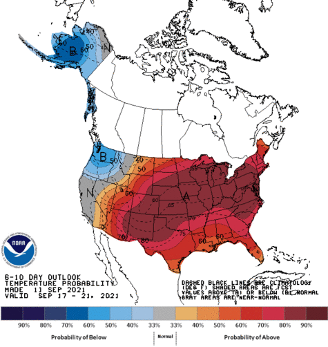
CPC also forecasts below normal highs with above normal precip for most of Texas starting next week.


This is going to be a pretty strong shot of cold air for October (if it plays out). Makes me wonder what we may be in store for if a similar shot of air works its way south in December or January.Portastorm wrote:I should probably add that the Euro is also on board with this pattern change and the dramatic cooldown mid to latter part of next week. That's another reason why I'm thinking this deals coming down ...
What I think would be great is a nice light 1-3" snowfall across all of SE Texas and then have it stick around and not melt for 3-5 days. I do not wish for the bitter cold and the windchills, but I do hope we get a nice calm snowfall with temps. hovering right around 32F for the duration and little to no wind. Now THAT would be nice. Then again, hoping for such a perfect scenario is definatley -removed-. There is no way we could ever hit all those specifications head on. Worth a wish though.KatDaddy wrote:Man I am ready for Winter. Lets see another snowfall for the Upper TX Coast and SE TX..........yes I am wishing casting a rather harmful event while remembering Christmas 2004..............that was amazing.
Return to “USA & Caribbean Weather”
Users browsing this forum: Brent, opticsguy, WeatherNewbie and 74 guests


