Mediterranean system

This is the general tropical discussion area. Anyone can take their shot at predicting a storms path.

Moderator: S2k Moderators

Forum rules

The posts in this forum are NOT official forecasts and should not be used as such. They are just the opinion of the poster and may or may not be backed by sound meteorological data. They are NOT endorsed by any professional institution or STORM2K. For official information, please refer to products from the National Hurricane Center and National Weather Service.

Help Support Storm2K
Message
Author
User avatar
TheEuropean
Professional-Met
Professional-Met
Posts: 1796
Age: 59
Joined: Tue Sep 20, 2005 3:17 pm
Location: Voerde, Germany
Contact:

Mediterranean system

#1 Postby TheEuropean » Mon Oct 16, 2006 2:28 pm

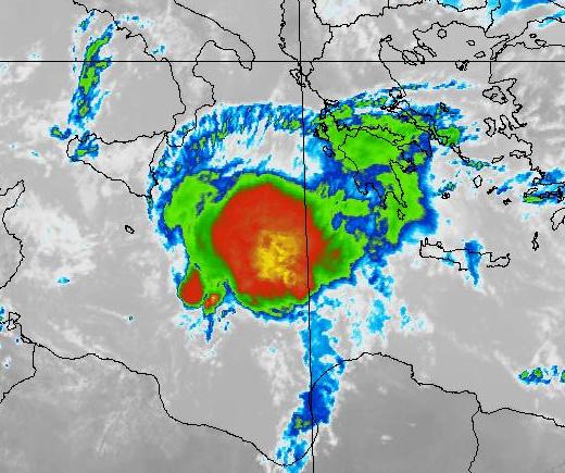
Look here:

Image
(Source: NEMOC)

An impressive system today in the central Mediterranean Sea with nice outflow to the north. This system will make landfall in southern Greece in the next few hours.

Last nite it hit the island of Malta, where as much as 4.5 Inches rain fell and gust up to storm force uprooted trees.
0 likes   

Derek Ortt

#2 Postby Derek Ortt » Mon Oct 16, 2006 2:33 pm

http://manati.orbit.nesdis.noaa.gov/dat ... MBas37.png

QS indicates a POSSIBLE closed surface circulation. This pass is from very early this morning. Of course, the afternoon pass missed

Who has responsibility for this area, or is the Medeterranean considered part of the Atlantic?
0 likes   

User avatar
TheEuropean
Professional-Met
Professional-Met
Posts: 1796
Age: 59
Joined: Tue Sep 20, 2005 3:17 pm
Location: Voerde, Germany
Contact:

#3 Postby TheEuropean » Mon Oct 16, 2006 2:49 pm

Derek Ortt wrote:Who has responsibility for this area, or is the Medeterranean considered part of the Atlantic?


Hi Derek,

I think it's part of the atlantic. The system now is getting weaker, but there will be heavy rainfall in parts of Greece, especially on the island of Crete.
0 likes   

User avatar
DESTRUCTION5
Category 5
Category 5
Posts: 4423
Age: 43
Joined: Wed Sep 03, 2003 11:25 am
Location: Stuart, FL

#4 Postby DESTRUCTION5 » Mon Oct 16, 2006 2:56 pm

No El nino there! LOL
0 likes   

User avatar
P.K.
Professional-Met
Professional-Met
Posts: 5149
Joined: Thu Sep 23, 2004 5:57 pm
Location: Watford, England
Contact:

#5 Postby P.K. » Mon Oct 16, 2006 2:57 pm

Derek Ortt wrote:Who has responsibility for this area, or is the Medeterranean considered part of the Atlantic?


Greece cover this area, although Meteo-France prepare the western half of the Mediterranean (Still within MetArea III). http://weather.gmdss.org/image/metarea3.jpg It can't really be part of the North Atlantic as that would be MetArea I, II, IV, or V. Met Office analysis chart is here, which has it as a 1006hPa low as of 1200 GMT. Nearer to that quickscat image is the 0000 GMT analysis at http://www.wetterzentrale.de/archive/2006/brack/bracka20061016.gif.

WWME22 LGAT 161930
NATIONAL METEOROLOGICAL SERVICE
ATHENS MARINE METEOROLOGICAL CENTRE

TTT GALE WARNING 16-10-06 / 1930 UTC
VALID FROM 162200 UTC UP TO 171000 UTC

HIGH PRESSURES 1025 OVER NORTH BALKANS ARE COMBINED WITH BAROMETRIC
LOW 1012 OVER BLACK SEA WHILE ANOTHER BAROMETRIC LOW 1007 OVER SIDRA
IS DEPENING MOVING SLOWLY EASTWARDS AFFECTING :

BOOT WITH NORTH NORTHEAST NEAR GALE 7 LOCALLY GALE 8

SIDRA WITH CYCLONIC NEAR GALE 7 LOCALLY GALE 8 AND FROM 170000 UTC
NORTH OF 34.00 WITH NORTH NORTHEAST GALE 8 LOCALLY STRONG GALE 9 AND
SOUTH OF 34.00 WITH NORTHWEST GALE 8

SOUTH IONIO SOUTH OF 37.00 WITH EAST NORTHEAST NEAR GALE 7 LOCALLY
GALE 8 AND FROM 170400 UTC NORTHEAST GALE 8 LOCALLY STRONG GALE 9

FROM 170400 UTC SOUTH IONIO NORTH OF 37.00 WITH NORTHEAST NEAR GALE
7 UP TO GALE 8

KITHIRA SEA WITH EAST NORTHEAST NEAR GALE 7 LOCALLY GALE 8 AND FROM
170400 UTC WITH NORTHEAST STRONG GALE 9

SOUTHWEST KRITIKO WITH CYCLONIC WEST OF 23.30 GALE 8 LOCALLY STRONG
GALE 9 AND FROM 170400 UTC WEST OF 23.30 STRONG GALE 9 AND EAST OF
23.30 NEAR GALE 7 LOCALLY GALE 8

FROM 170400 UTC WEST KRITIKO SOUTHWEST AEGEAN AND SOUTHEAST AEGEAN
IKARIO WEST OF 24.30 WITH NORTHEAST NEAR GALE 7 LOCALLY GALE 8

WEST BLACK SEA WEST OF 32.00 WITH NORTH NEAR GALE 7 LOCALLY GALE 8=
0 likes   

User avatar
johngaltfla
Category 5
Category 5
Posts: 2069
Joined: Sun Jul 10, 2005 9:17 pm
Location: Sarasota County, FL
Contact:

#6 Postby johngaltfla » Mon Oct 16, 2006 3:56 pm

Wouldn't that be fascinating if the new wave of El Nino's spawned a series of Hurricanes in the Med and in the South Atlantic. This would turn decades of research on it's ear, would it not gang?
0 likes   

JonathanBelles
Professional-Met
Professional-Met
Posts: 11430
Age: 35
Joined: Sat Dec 24, 2005 9:00 pm
Location: School: Florida State University (Tallahassee, FL) Home: St. Petersburg, Florida
Contact:

#7 Postby JonathanBelles » Mon Oct 16, 2006 4:46 pm

it would defininatly be interestin to see a hurricane in the mediteranean
0 likes   

User avatar
HURAKAN
Professional-Met
Professional-Met
Posts: 46086
Age: 38
Joined: Thu May 20, 2004 4:34 pm
Location: Key West, FL
Contact:

#8 Postby HURAKAN » Mon Oct 16, 2006 5:50 pm

fact789 wrote:it would defininatly be interestin to see a hurricane in the mediteranean


Image

HAPPY!!!

Another perspective:
ftp://eclipse.ncdc.noaa.gov/pub/isccp/b ... T-5-IR.jpg

Look how small the system is and that is completely separated from any frontal system.
0 likes   

User avatar
Yarrah
Category 2
Category 2
Posts: 658
Joined: Tue Feb 07, 2006 6:15 pm
Location: Utrecht, The Netherlands
Contact:

#9 Postby Yarrah » Mon Oct 16, 2006 5:57 pm

Well, as long as they stay out of the North Sea... :wink:

But seriously, this system look pretty good, even though I don't think it's something very special. These kind of low pressure systems tend to form quite often during this time of the year
0 likes   

User avatar
P.K.
Professional-Met
Professional-Met
Posts: 5149
Joined: Thu Sep 23, 2004 5:57 pm
Location: Watford, England
Contact:

#10 Postby P.K. » Mon Oct 16, 2006 6:16 pm

The one last month even had an "eye". http://forum.meteogiornale.it/showthread.php?t=24173&page=2

I know I'm not supposed to link to other forums than affliated sites but this one is in Italian so I hope its ok.
0 likes   

User avatar
HURAKAN
Professional-Met
Professional-Met
Posts: 46086
Age: 38
Joined: Thu May 20, 2004 4:34 pm
Location: Key West, FL
Contact:

#11 Postby HURAKAN » Mon Oct 16, 2006 6:39 pm

Thanks P.K for sharing that. Very interesting.
0 likes   

User avatar
Bob R
S2K Supporter
S2K Supporter
Posts: 30
Age: 73
Joined: Mon May 30, 2005 5:18 am
Location: Palm Beach Gardens, Florida

#12 Postby Bob R » Mon Oct 16, 2006 6:48 pm

Wow!
Just got back 2 days ago from a cruise in the Med (went from Barcelona to Naples and back)... fortunately, we had great weather with calm seas and not a bit of rain.
0 likes   

JonathanBelles
Professional-Met
Professional-Met
Posts: 11430
Age: 35
Joined: Sat Dec 24, 2005 9:00 pm
Location: School: Florida State University (Tallahassee, FL) Home: St. Petersburg, Florida
Contact:

#13 Postby JonathanBelles » Mon Oct 16, 2006 7:03 pm

the European where did you get that image?
0 likes   

User avatar
Ptarmigan
Category 5
Category 5
Posts: 5319
Joined: Wed Aug 16, 2006 9:06 pm

#14 Postby Ptarmigan » Mon Oct 16, 2006 7:27 pm

HURAKAN wrote:
fact789 wrote:it would defininatly be interestin to see a hurricane in the mediteranean


Image

HAPPY!!!

Another perspective:
ftp://eclipse.ncdc.noaa.gov/pub/isccp/b ... T-5-IR.jpg

Look how small the system is and that is completely separated from any frontal system.


Assuming it is a hurricane, that is one tiny hurricane.
0 likes   

JonathanBelles
Professional-Met
Professional-Met
Posts: 11430
Age: 35
Joined: Sat Dec 24, 2005 9:00 pm
Location: School: Florida State University (Tallahassee, FL) Home: St. Petersburg, Florida
Contact:

#15 Postby JonathanBelles » Mon Oct 16, 2006 9:17 pm

can somebody provide a link to a mediteranean satelite?
0 likes   

HurricaneBill
Category 5
Category 5
Posts: 3420
Joined: Sun Apr 11, 2004 5:51 pm
Location: East Longmeadow, MA, USA

#16 Postby HurricaneBill » Mon Oct 16, 2006 9:57 pm

Ptarmigan wrote:
Assuming it is a hurricane, that is one tiny hurricane.


I wonder if that's what the 1935 Labor Day Hurricane looked like. Yes, I know that 1995 storm was nowhere near the intensity of the 1935 hurricane.
0 likes   

User avatar
Ptarmigan
Category 5
Category 5
Posts: 5319
Joined: Wed Aug 16, 2006 9:06 pm

#17 Postby Ptarmigan » Mon Oct 16, 2006 10:00 pm

HurricaneBill wrote:
I wonder if that's what the 1935 Labor Day Hurricane looked like. Yes, I know that 1995 storm was nowhere near the intensity of the 1935 hurricane.


From what I know, the 1935 hurricane was very small. Mainland Florida and Key West did not even feel it. It was like a tornado.
0 likes   

User avatar
TheEuropean
Professional-Met
Professional-Met
Posts: 1796
Age: 59
Joined: Tue Sep 20, 2005 3:17 pm
Location: Voerde, Germany
Contact:

#18 Postby TheEuropean » Tue Oct 17, 2006 2:24 pm

System made landfall in Greece today and dropped about 3.3 Inches of rain on parts of the island of Crete. Further to the north at Naxos Airport highest gust was measured with 68 kts.
0 likes   

Matt-hurricanewatcher

#19 Postby Matt-hurricanewatcher » Wed Oct 18, 2006 3:17 pm

How warm are the waters there? Also what could support this has a cyclone, if it is in fact one. Looks like one.
0 likes   

User avatar
Yarrah
Category 2
Category 2
Posts: 658
Joined: Tue Feb 07, 2006 6:15 pm
Location: Utrecht, The Netherlands
Contact:

#20 Postby Yarrah » Wed Oct 18, 2006 5:28 pm

Water's about 23°C.

Image

The main problem with this area is the fact that it's so close to a desert and the air is way too dry most of the times.

I saw some footage from Crete on the news and it showed some heavy flooding and damage. Also, the south-western part of Turkey has recieved some heave rainfall too.
0 likes   


Return to “Talkin' Tropics”

Who is online

Users browsing this forum: Bobbyh83, facemane, Frank P, islandgirl45, JtSmarts, Kazmit, Lizzytiz1, pepecool20, riapal, SFLcane, sunny and 101 guests