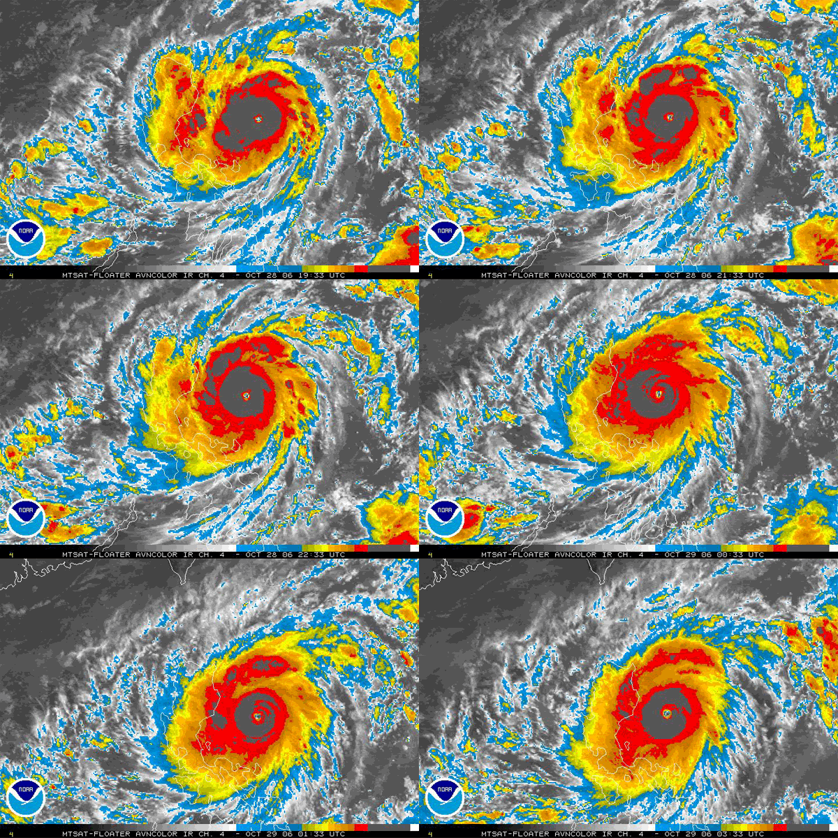
Typhoon Cimaron in WPAC
Moderator: S2k Moderators
Forum rules
The posts in this forum are NOT official forecasts and should not be used as such. They are just the opinion of the poster and may or may not be backed by sound meteorological data. They are NOT endorsed by any professional institution or STORM2K. For official information, please refer to products from the National Hurricane Center and National Weather Service.
-
whereverwx
- Category 5

- Posts: 1107
- Joined: Mon May 31, 2004 10:15 pm
- wxmann_91
- Category 5

- Posts: 8007
- Age: 34
- Joined: Fri Jul 15, 2005 2:49 pm
- Location: Southern California
- Contact:
Category 5 wrote:calamity wrote:Wow, AWESOME image, wxmann_91!
Ditto, I must have it
Thanks...I made it using the Dundee data. Ahh I love the full disks.
Edit: the new modis images are up.
Visible
Infrared
Water Vapor
0 likes
-
whereverwx
- Category 5

- Posts: 1107
- Joined: Mon May 31, 2004 10:15 pm
Do they have any radar stations in the Philippines? I don't think do? It would be interesting to see what a storm like this looks like under a, say, Nexrad, for example.


Last edited by whereverwx on Sat Oct 28, 2006 11:49 pm, edited 1 time in total.
0 likes
- cheezyWXguy
- Category 5

- Posts: 6282
- Joined: Mon Feb 13, 2006 12:29 am
- Location: Dallas, TX
- Aslkahuna
- Professional-Met

- Posts: 4549
- Joined: Thu Feb 06, 2003 5:00 pm
- Location: Tucson, AZ
- Contact:
One other thing, a 920 mb storm in WPAC is not quite as intense as a 920 mb storm in the ATL under most circumstances since the storms form in a lower ambient pressure and thus have to have lower central pressures in order to build up a strong gradient. In order to have 140kt winds like Andrew, a WPAC storm needs to be at around 895mb. September through November is Super season in WPAC so Cimaron is not an unusual happenstance in this particular part of WPAC this time of year.
Steve
Steve
0 likes
-
HurricaneBill
- Category 5

- Posts: 3419
- Joined: Sun Apr 11, 2004 5:51 pm
- Location: East Longmeadow, MA, USA
JTWC fix from earlier:
155
TPPN10 PGTW 290328 COR
A. SUPER TYPHOON 22W (CIMARON)
B. 29/0230Z
C. 16.2N/9
D. 124.1E/8
E. ONE/MTSAT
F. T7.0/7.0/D3.0/24HRS STT: D0.5/03HRS (29/0230Z)
G. IR/EIR/VIS/MSI LLCC
03A/PBO EYE/ANMTN. 25NM WMG EYE SURROUNDED BY CMG ADDED 1.0 EYE
ADJ YIELDS 7.5. PT GIVES 7.0. DBO PT. UNREPRESENTATIVE MET GIVES
5.5. BROKE CONSTRAINTS DUE TO RAPID INTENSIFICATION. AODT: 7.6.
COR'D FOR LINE G - DT/PT COMMENTS.
DELEO
Last edited by Chacor on Sun Oct 29, 2006 12:50 am, edited 2 times in total.
0 likes
- AussieMark
- Category 5

- Posts: 5857
- Joined: Tue Sep 02, 2003 6:36 pm
- Location: near Sydney, Australia
-
HurricaneBill
- Category 5

- Posts: 3419
- Joined: Sun Apr 11, 2004 5:51 pm
- Location: East Longmeadow, MA, USA
AussieMark wrote:Steve just out of curiosity is October the month that Phillipines are most likely to be hit by strong typhoons
just from memory
Angelea, Zeb and Babs were all intense October typhoons
October and November.
Unfortunately, they also tend to come in pairs. Let's hope another one doesn't follow Cimaron.
0 likes
HurricaneBill wrote:AussieMark wrote:Steve just out of curiosity is October the month that Phillipines are most likely to be hit by strong typhoons
just from memory
Angelea, Zeb and Babs were all intense October typhoons
October and November.
Unfortunately, they also tend to come in pairs. Let's hope another one doesn't follow Cimaron.
Perhaps Cimaron is following Xangsane?
0 likes
Aslkahuna wrote:One other thing, a 920 mb storm in WPAC is not quite as intense as a 920 mb storm in the ATL under most circumstances since the storms form in a lower ambient pressure and thus have to have lower central pressures in order to build up a strong gradient. In order to have 140kt winds like Andrew, a WPAC storm needs to be at around 895mb. September through November is Super season in WPAC so Cimaron is not an unusual happenstance in this particular part of WPAC this time of year.
Steve
Super Typhoon Tip formed in October of 1979. It had a pressure of 870 mb and winds of 140 kt to 165 kt.
0 likes
-
Typhoon Hunter
- WesternPacificWeather.com

- Posts: 1222
- Joined: Wed Oct 11, 2006 11:37 am
- Location: Tokyo
- Contact:
!
Here's the latest update from JMA....down to 910HPA. They expect some re-intensification in the South China Sea.
Issued at 06:00 UTC 29 Oct 2006RSMC TROPICAL CYCLONE ADVISORY
NAME TY 0619 CIMARON (0619)
ANALYSIS
PSTN 290600UTC 16.3N 123.6E GOOD
MOVE WNW 10KT
PRES 910HPA
MXWD 105KT
50KT 90NM
30KT 160NM
FORECAST
24HF 300600UTC 17.4N 120.9E 80NM 70%
MOVE WNW 07KT
PRES 940HPA
MXWD 085KT
48HF 310600UTC 17.2N 118.0E 150NM 70%
MOVE W 06KT
PRES 960HPA
MXWD 075KT
72HF 010600UTC 17.3N 115.8E 220NM 70%
MOVE W SLOWLY
PRES 955HPA
MXWD 080KT
0 likes
Who is online
Users browsing this forum: No registered users and 188 guests

