Eastern Pacific satellite loop has switched over!!!
http://www1.cira.colostate.edu/ramm/rms ... PICAL.html
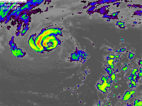
91C.Invest - Very far to the north (42.5 N, 146.5 W)
Moderator: S2k Moderators
Forum rules

The posts in this forum are NOT official forecasts and should not be used as such. They are just the opinion of the poster and may or may not be backed by sound meteorological data. They are NOT endorsed by any professional institution or STORM2K. For official information, please refer to products from the National Hurricane Center and National Weather Service.


-
Matt-hurricanewatcher

This is surprising. That is very north and in the Central Pacific too. Has a system ever formed that far north in either the Eastern or Central Pacific basins? I haven't heard or seen one. Also the date is like November 1. Does it have what it takes to be a tropical cyclone? Man, I would love recon to go into this. It looks like a mini hurricane that isn't fully tropical. Very cool.
0 likes


-
craptacular
- Category 2

- Posts: 581
- Joined: Wed Aug 02, 2006 9:17 pm
- Location: The Mad City, WI
-
JonathanBelles
- Professional-Met

- Posts: 11430
- Age: 35
- Joined: Sat Dec 24, 2005 9:00 pm
- Location: School: Florida State University (Tallahassee, FL) Home: St. Petersburg, Florida
- Contact:
-
Hurricanehink

- S2K Supporter

- Posts: 2047
- Joined: Sun Nov 16, 2003 2:05 pm
- Location: New Jersey
-
Derek Ortt

This certainly looks like a subtropical storm per satellite imagery now. Subtropical with 30-40kt winds? I am not surprised a surface low could intensify with baroclinic forcing at such a high lat in the eastern Pacific, but I am surprised at its persistance and structure. Derek did bring up an important bit about atmospheric temperatures vs. SSTs with relation to thunderstorm development. No, you do not have to have 26º SSTs to intensify a warm core surface low if your surface air temps are far cooler than the SST temp. Evaporation will still occur and instability will assist in uplift/thunderstorm development. We see plenty of examples of this with storms that have formed in the eastern Atlantic at high latitudes. However, the thing that surprises me about this storm is that there is only a 10º difference between 950mb air temperature and SST temperature. I am surprised there can be enough evaporation to support this, but then again, the thundestorms aren't all that impressive. Pretty fascinating stuff to say the least.
Also, with regards to the "eye" comments, we have seen many times in the past where a strong surface vortex can form in an intensifying surface low that is not purely tropical and the thunderstorms will wrap around a center to give the appearance of an eye. We have seen this occur with several strong nor'easters moving just off the east coast of the U.S. These usually weak thunderstorms are not an eyewall feature, they usually just rotate around a dry region of the center sometimes making the storm look like a hurricane when it is not. This storm appears to be doing the same thing. In contrast, the eye of a hurricane is the result of high pressure and warm, stable sinking air (spent fuel at the top of the wall column) that has nowhere to go but down if too close to the center; though the bulk of the air gets evacuated at the tropopause away from the center thanks to your resulting upper-level high. Of course, most of you already know this phenomenon well enough. I'm just reminding folks. We don't have that situation here with this particular storm.
Also, with regards to the "eye" comments, we have seen many times in the past where a strong surface vortex can form in an intensifying surface low that is not purely tropical and the thunderstorms will wrap around a center to give the appearance of an eye. We have seen this occur with several strong nor'easters moving just off the east coast of the U.S. These usually weak thunderstorms are not an eyewall feature, they usually just rotate around a dry region of the center sometimes making the storm look like a hurricane when it is not. This storm appears to be doing the same thing. In contrast, the eye of a hurricane is the result of high pressure and warm, stable sinking air (spent fuel at the top of the wall column) that has nowhere to go but down if too close to the center; though the bulk of the air gets evacuated at the tropopause away from the center thanks to your resulting upper-level high. Of course, most of you already know this phenomenon well enough. I'm just reminding folks. We don't have that situation here with this particular storm.
0 likes
-
Matt-hurricanewatcher
-
Matt-hurricanewatcher
-
Hurricanehink
- S2K Supporter
- Posts: 2047
- Joined: Sun Nov 16, 2003 2:05 pm
- Location: New Jersey
Who is online
Users browsing this forum: Ulf and 72 guests