North Texas Weather - A Brief Break from the Rain?
Moderator: S2k Moderators
Forum rules

The posts in this forum are NOT official forecast and should not be used as such. They are just the opinion of the poster and may or may not be backed by sound meteorological data. They are NOT endorsed by any professional institution or STORM2K.
-
TexasStooge

- Category 5

- Posts: 38127
- Joined: Tue Mar 25, 2003 1:22 pm
- Location: Irving (Dallas County), TX
- Contact:
-
gboudx

- S2K Supporter

- Posts: 4090
- Joined: Thu Sep 04, 2003 1:39 pm
- Location: Rockwall, Tx but from Harvey, La
I have a laser temp reader that I'm certain is accurate. I often check it's calibration against other thermometers for accuracy. This morning it recorded a temp of 34 in my backyard. And that would go along with the frost on my kids play equipment and on rooves of homes in my neighborhood.
Looks like some nice chances of rain still forecasted mid-week.
Looks like some nice chances of rain still forecasted mid-week.
0 likes
-
CaptinCrunch

- S2K Supporter
- Posts: 8776
- Age: 57
- Joined: Mon Nov 03, 2003 4:33 pm
- Location: Kennedale, TX (Tarrant Co.)
-
gboudx
- S2K Supporter
- Posts: 4090
- Joined: Thu Sep 04, 2003 1:39 pm
- Location: Rockwall, Tx but from Harvey, La
I just noticed that someone in my neighborhood has a personal weather station. It recorded a low of 38.4 out here. I took my temp readings with my laser temp reader from near the ground, so maybe that's why it showed a cooler reading.
I may have to look into one of these weather stations. Or I could just borrow the readings from my new friend. It did show 3+ inches of rain from the 10/14-10/15 event.
I may have to look into one of these weather stations. Or I could just borrow the readings from my new friend.
0 likes
-
TexasStooge
- Category 5
- Posts: 38127
- Joined: Tue Mar 25, 2003 1:22 pm
- Location: Irving (Dallas County), TX
- Contact:
Tonight through Thursday, we'll see some occasional showers and possibly a thunderstorm here in the North Texas region, followed by Windy days ahead for Thursday and Friday. Temperatures will remain steady in the lower to mid 70s throughout the rest of the week with lows near 50 to the lower 60s.
Speaking of "Windy". a High Wind Watch is in effect for areas west of a Bowie, Graham, and Cisco line. It's not in effect for the immediate North Texas area yet, however, extra caution still needs to be taken.
Speaking of "Windy". a High Wind Watch is in effect for areas west of a Bowie, Graham, and Cisco line. It's not in effect for the immediate North Texas area yet, however, extra caution still needs to be taken.
0 likes

-
gboudx
- S2K Supporter
- Posts: 4090
- Joined: Thu Sep 04, 2003 1:39 pm
- Location: Rockwall, Tx but from Harvey, La
JenBayles wrote:Same problem here with HGX. Whassup?!
The problem most likely permeates to all regional sites that call the Southern Regional Headquarters home. I tried to ping the http://www.srh.noaa.gov domain, but get "Destination net unreachable". So that tells me any site like FWD, HGX, etc that reside in that domain will be unreachable. Either the server is down, or the network to the server is down.
Thanks for letting me know you're having problems with it too Jen. I didn't think it was just me, but sometimes the voices in my head are right.
0 likes

sounds like your were right gboudx.
...Major Outage of One of the NWS Web Server Farms...
This afternoon the fiber optic cable connection to the Internet from the Southern Region Web server farm was cut. Web sites beginning with http://www.srh.noaa.gov ... as well as mobile phone pages and some radar images are impacted by this communications outage. Technicians are working to restore service as quickly as possible and automatic Web page redirects are being implemented.
0 likes
-
gboudx
- S2K Supporter
- Posts: 4090
- Joined: Thu Sep 04, 2003 1:39 pm
- Location: Rockwall, Tx but from Harvey, La
Thanks double D.
Here's the AFD for this afternoon for DFW.
AREA FORECAST DISCUSSION
NATIONAL WEATHER SERVICE FORT WORTH TX
215 PM CDT WED OCT 25 2006
...SEVERE THUNDERSTORM POSSIBLE THURSDAY AFTERNOON ALONG AND EAST OF
I-35...
.DISCUSSION...
RAIN SHIELD IS SHIFTING EAST AND ENDING OVER THE WESTERN AREAS.
REMAINING RAIN THIS EVENING WILL BE OVER THE SOUTHEAST THIRD ONLY.
LAST NIGHTS ISENTROPIC PROCESS WAS MUCH WEAKER THAN EXPECTED...THUS
RAINFALL AMOUNTS WERE MUCH LESS...WITH MOST OF IT FALLING SOUTH OF A
COMANCHE TO EMORY LINE. AT 18Z TODAY 24 HOUR RAIN AMOUNTS WERE:
KGRK=1.64", KHLR=1.41", KACT=0.97" KDFW=0.08" KMWL=0.23", KTRL=0.20"
AND KTKI=0.72". MANY OTHER REPORTS OF 1/10".
UPPER LOW TO THE NORTHWEST STILL RUNNING ABOUT 12 HOURS SLOWER THAN
WHAT WAS INDICATED YESTERDAY AND THE DAY BEFORE. THIS WILL HAVE BIG
CONSEQUENCES FOR NORTH TEXAS THURSDAY INTO FRIDAY DUE TO TIMING.
SURFACE LOW WILL TRACK ACROSS OKLAHOMA THURSDAY NIGHT WITH STRONG
DRYLINE PUSHING TO NEAR I-35 BY MIDDAY AND ACROSS THE EASTERN CWA
DURING THE AFTERNOON. STRONG DYNAMICS ALOFT...100+KT 250MB SPEED
MAX...STRONG PVA AND SHEAR...SURFACE CONVERGENCE AND HEATING WILL
LEAD TO THE DEVELOPMENT OF A SQUALL LINE AHEAD OF THE DRYLINE IN
S.OKLA THAT BUILDS SOUTHWARD ACROSS THE EASTERN CWA. SEVERE
THUNDERSTORMS ARE POSSIBLE MAINLY EAST OF I-35 THURSDAY
AFTERNOON/EVENING.
AFTERWARDS...DEEP SURFACE LOW OVER OKLA PUSHES EAST WITH VERY TIGHT
PRESSURE GRADIENT ACROSS NORTH TEXAS THURSDAY NIGHT AND FRIDAY.
CURRENTLY...THINK WINDS THURSDAY NIGHT WILL BE 20-25MPH BUT FRIDAYS
COULD BE IN THE ADVISORY CRITERIA.
STRONG COLD AIR ADVECTION WITH THIS FRONT WILL BE OVER THE NORTHEAST
QUARTER...THUS HAVE NOT GONE REAL COLD WITH THIS FRONT.
ALSO...WEEKEND BACKDOOR FRONT WILL NOT ENTER THE REGION THUS WEEKEND
TEMPS WILL MODERATE HIGHS REBOUNDING INTO THE MID/UPPER 70S.
NEXT WEATHER MAKER IS NEXT MONDAY NIGHT AS ANOTHER UPPER LEVEL
TROUGH AND COLD FRONT MOVE THROUGH NORTH TEXAS WITH COOLER AIR
TUESDAY AND WEDNESDAY AND A SLIGHT CHANCE OF RAIN OVER THE EASTERN
CWA ON TUESDAY.
0 likes
-
TexasStooge
- Category 5
- Posts: 38127
- Joined: Tue Mar 25, 2003 1:22 pm
- Location: Irving (Dallas County), TX
- Contact:
double D wrote:sounds like your were right gboudx.
...Major Outage of One of the NWS Web Server Farms...
This afternoon the fiber optic cable connection to the Internet from the Southern Region Web server farm was cut. Web sites beginning with http://www.srh.noaa.gov ... as well as mobile phone pages and some radar images are impacted by this communications outage. Technicians are working to restore service as quickly as possible and automatic Web page redirects are being implemented.
No wonder I was seeing red "X"s in place of the maps and radars on my weather site.
0 likes
-
TexasStooge
- Category 5
- Posts: 38127
- Joined: Tue Mar 25, 2003 1:22 pm
- Location: Irving (Dallas County), TX
- Contact:
Well, we could see another round of showers and thunderstorms this afternoon and evening, and some may reach severe limits as a strong upper level system moves into the southern plains. Areas most likely to get severe weather are along and east of a Sherman, Dallas, Waco, and Temple line where the dry line will be at 4:00PM CDT. After tonight, winds will be gusting as high as 30 MPH through Early Saturday with highs falling into the 60s on Friday as a cold front passes through the area.
Check the NWS - Fort Worth homepage for more info.
Check the NWS - Fort Worth homepage for more info.
0 likes
-
TexasStooge
- Category 5
- Posts: 38127
- Joined: Tue Mar 25, 2003 1:22 pm
- Location: Irving (Dallas County), TX
- Contact:
I wasn't kidding when I said it's gonna be windy all day today. It'll be Partly Cloudy with highs in the upper 60s and lows near 50. The National Weather Service has issued a Wind Advisory for all of the North Texas area until 6:00PM CDT. We'll have wind gusts of 25-35 MPH with higher gusts in some areas up to 45 MPH in wake of a fast moving cold front.
This is an actual forecast map of today:
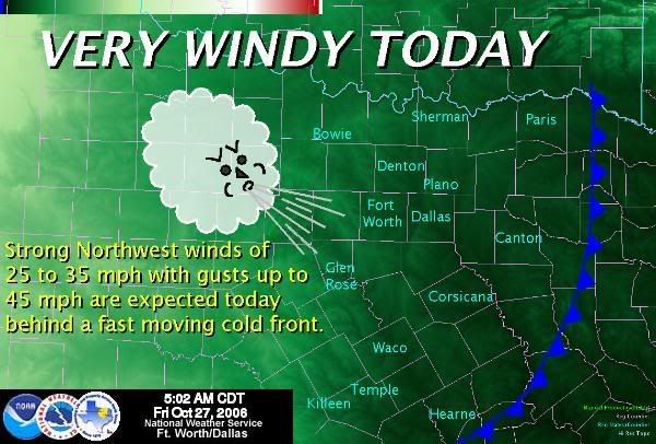
For more info, go to the NWS - Ft. Worth Homepage.
As for the rest of the forecast, we'll see clear skies on the weekend with highs in the mid 70s to lower 80s and lows in the 50s through Monday. On Halloween, we'll have a slight chance of thunderstorms, but it'll diminish by the time the kids go out Trick-Or-Treating. Highs from that day on will be in the upper 60s to lower 70s with lows in the upper 40s to lower 50s.
This is an actual forecast map of today:
For more info, go to the NWS - Ft. Worth Homepage.
As for the rest of the forecast, we'll see clear skies on the weekend with highs in the mid 70s to lower 80s and lows in the 50s through Monday. On Halloween, we'll have a slight chance of thunderstorms, but it'll diminish by the time the kids go out Trick-Or-Treating. Highs from that day on will be in the upper 60s to lower 70s with lows in the upper 40s to lower 50s.
0 likes
-
TexasStooge
- Category 5
- Posts: 38127
- Joined: Tue Mar 25, 2003 1:22 pm
- Location: Irving (Dallas County), TX
- Contact:
-
TexasStooge
- Category 5
- Posts: 38127
- Joined: Tue Mar 25, 2003 1:22 pm
- Location: Irving (Dallas County), TX
- Contact:
-
TexasStooge
- Category 5
- Posts: 38127
- Joined: Tue Mar 25, 2003 1:22 pm
- Location: Irving (Dallas County), TX
- Contact:
Tonight appears to be a nice Halloween night for some of the Trick-or-Treaters as skies appear to be Mostly Clear, however, some kids may need to wear a warm costume as low temperatures dip into the mid 40s as another passing cold front comes through the North Texas area.
Too bad we don't have a full moon outside.
Too bad we don't have a full moon outside.
0 likes
-
TexasStooge
- Category 5
- Posts: 38127
- Joined: Tue Mar 25, 2003 1:22 pm
- Location: Irving (Dallas County), TX
- Contact:
As I said before, it's gonna be a nice, yet nippy Halloween as temperatures dip into the mid to upper 40s. Any kids going trick or treating may need to wear something warm to go with their costume(s). A FREEZE WARNING is in effect for areas Northwest of the North Texas region, mainly west of Wichita Falls. Also, a Frost Advisory is in effect for cities west of the North Texas area, mainly in Abilene and west of Graham--those are not our primary concerns at the moment, but if you live outside the North Texas area and are under those weather alerts, take extra caution. Our next chance of rain will be from Friday Night on as temperatures maintain their autumn-like status. Click for forecast.
Speaking of rain, click on the map below for the latest drought info.

Speaking of rain, click on the map below for the latest drought info.
0 likes
-
TexasStooge
- Category 5
- Posts: 38127
- Joined: Tue Mar 25, 2003 1:22 pm
- Location: Irving (Dallas County), TX
- Contact:
This morning was a surprise for some of us in Dallas, Kaufman, and now Van Zandt and Rains counties. A storm developed in Downtown Dallas and is moving East. No severe weather is expected from this thunderstorm, but look out for frequent cloud to ground lightning, very heavy rainfall, and pea-size hail.
Otherwise, we're looking at Mostly Cloudy skies with highs in the mid to upper 50s and lows near 40. As for the next 7 days, we'll look at Mostly sunny/clear to partly cloudy skies on Thursday and Friday with highs near 60 and lows in the lower to upper 40s. And from Saturday on, we'll see some rain and thunderstorms, with the best chances this weekend, highs will be in the upper 50s to lower 70s and lows in the lower 50s to lower 60s.
Otherwise, we're looking at Mostly Cloudy skies with highs in the mid to upper 50s and lows near 40. As for the next 7 days, we'll look at Mostly sunny/clear to partly cloudy skies on Thursday and Friday with highs near 60 and lows in the lower to upper 40s. And from Saturday on, we'll see some rain and thunderstorms, with the best chances this weekend, highs will be in the upper 50s to lower 70s and lows in the lower 50s to lower 60s.
0 likes
-
TexasStooge
- Category 5
- Posts: 38127
- Joined: Tue Mar 25, 2003 1:22 pm
- Location: Irving (Dallas County), TX
- Contact:
UPDATED FORECAST: For tonight, we'll see decreasing cloudiness with lows near 40. Thursday to Friday afternoon, we'll have Mostly Sunny/Clear to Partly Cloudy skies with highs in the lower to mid 60s and lows in the upper 30s.  And from Friday night on, we'll see a chance of rain and thunderstorms with lows in the mid 40s to upper 50s and highs near 60 to the mid 70s.
Freeze warnings and frost advisories are once again for areas west of the North Texas area, again--nothing to worry about unless the advisories are issued for our area...which will more likely happen on Thursday night.
And from Friday night on, we'll see a chance of rain and thunderstorms with lows in the mid 40s to upper 50s and highs near 60 to the mid 70s.
Freeze warnings and frost advisories are once again for areas west of the North Texas area, again--nothing to worry about unless the advisories are issued for our area...which will more likely happen on Thursday night.
0 likes
-
gboudx
- S2K Supporter
- Posts: 4090
- Joined: Thu Sep 04, 2003 1:39 pm
- Location: Rockwall, Tx but from Harvey, La
Looking very wet the next 5 days. Though this could cause some flooding problems in the area, it would be needed for the drought.
http://www.hpc.ncep.noaa.gov/qpf/p120i12.gif
http://www.hpc.ncep.noaa.gov/qpf/p120i12.gif
0 likes
Return to “USA & Caribbean Weather”
Who is online
Users browsing this forum: No registered users and 65 guests