http://www.ssd.noaa.gov/goes/east/nwatl/loop-wv.html
http://www.ssd.noaa.gov/goes/east/nwatl/loop-ir2.html
bouy 42 miles south of charleston , SC
http://www.ndbc.noaa.gov/station_page.php?station=41004
1150 = 43mph g49 29.96 falling
bouy tgy bn (40 miles to the sw of other bouy)
42 mph g 49 29.91 falling
also two water spouts in strong thunderstorms off n fl coast 25-30 miles offshore
very dynamic SE coastal storm forming
Moderator: S2k Moderators
Forum rules

The posts in this forum are NOT official forecast and should not be used as such. They are just the opinion of the poster and may or may not be backed by sound meteorological data. They are NOT endorsed by any professional institution or STORM2K.


51mph gusts to 60 mph
charleston bouy 42miles south of 29.88
http://www.ssd.noaa.gov/goes/east/nwatl/loop-ir2.html
charleston bouy 42miles south of 29.88
http://www.ssd.noaa.gov/goes/east/nwatl/loop-ir2.html
0 likes

-
HurricaneGirl

- Category 5

- Posts: 5838
- Age: 61
- Joined: Thu Feb 06, 2003 9:45 am
- Location: Clare, Michigan
- Contact:
looks like the trough digging in the southern yes southern GOM is still digging though cuba and about to bottomout this evening, with the cold ULL bringing the drier air into the nw bahamas later this afternoon, it appears the northern part of this "hybrid" storm will like to retrograde westward while the southern (less prounounced) half of the storm will swing just a bit more south and then tilt east
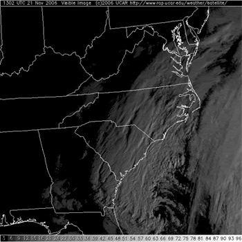
it seems we may have a MONSTER about 100 miles off the coast of somewhere between savanah ga and jacksonville, fl tonite
since it appears a little further south than forecast and not expected to move till late wed.
you can see the storm is in it's developing stages as the deep atlantic and (tropical moisture feed is just starting to rap around into the consolidating circulation) and effect the outer banks also the sysem is also moving out over the gulf stream east of fl/ga border
this will have quite a signature on visible satelite by late this afternoon
http://www.ssd.noaa.gov/goes/east/nwatl/loop-vis.html
0 likes
-
vbhoutex

- Storm2k Executive

- Posts: 29149
- Age: 74
- Joined: Wed Oct 09, 2002 11:31 pm
- Location: Cypress, TX
- Contact:
This system is wrapping up and doing it quickly too. It looks like it will be quite a blow for the areas it affects. Fortunately most of the areas that will apparently will have the biggest effects will be out to sea. If it tracks further West there could be some surprises for the coastal areas, past the bad weather already predicted.
0 likes


JAX AFD:
BAND OF PRECIP HAS HELD OFFSHORE FOR MOST OF THE DAY BUT IS NOW
WORKING INLAND OVER SE GA AND SHOULD SPREAD INTO EXTREME NE
FLORIDA THIS EVENING AS LOW LEVEL JET WRAPS AROUND THE WEST SIDE
OF THE STORM. SHOULD CONTINUE TO BE A PRETTY ABRUPT SOUTHWEST EDGE
TO THE PRECIP SHIELD WITH WESTERN AND SOUTHWESTERN PORTIONS OF THE
CWA SEEING VERY LITTLE MEASURABLE PRECIP. BEST RAIN CHANCES WILL
BE ALONG THE SE GA COAST. PARTIAL THICKNESSES AND MODEL SOUNDINGS FOR THIS EVENING DO SUPPORT A FEW SLEET PELLETS OF SNOW FLAKES MIXED IN WITH THE RAIN . WARM BOUNDARY LAYER SHOULD PREVENT THIS
EXCEPT IN HEAVIER SHOWERS. WILL NOT MENTION THIS IN THE ZONES.
0 likes
-
Weatherfreak14

- Category 5
- Posts: 1381
- Joined: Sat Sep 24, 2005 3:40 pm
- Location: Beaufort, SC
- Contact:
Are area afd in beufort says its to warm up over night to 45 but it is 31 right now dome ice is forming in areas and iy is misting i dont see how it can warm up and i dont see any warm air coming in from anywhere. after dark all i can see happening is wntry precip cuz its never hit anywhere near the high for today of 48. and it never made it out of the 30s.
0 likes
-
storms in NC

- S2K Supporter

- Posts: 2338
- Joined: Thu Jul 28, 2005 2:58 pm
- Location: Wallace,NC 40 miles NE of Wilm
- Contact:

We've had some snow and sleet - just for about 30 mins at a time around noon here today... winds have been around 10 mph with gusts to 20 earlier today.
Special Weather Statement
http://www.srh.noaa.gov/fwd/productview ... &version=0
Special Weather Statement
...BLUSTERY WET WEATHER TO PERSIST ACROSS CENTRAL NORTH CAROLINA...
AN UNUSUALLY INTENSE SLOW-MOVING LOW PRESSURE SYSTEM WILL MOVE
NORTH ALONG THE COAST OF THE CAROLINAS CAUSING PERSISTENT STRONG
WINDS...WIDESPREAD RAIN...AND CHILLY TEMPERATURES THROUGH
THANKSGIVING DAY.
RAINFALL AMOUNTS WITH THIS EVENT ARE EXPECTED TO RANGE FROM AROUND
ONE INCH IN THE WEST TO AROUND 3 INCHES IN THE EAST WITH LOCALLY
HEAVIER AMOUNTS POSSIBLE IN THE COASTAL PLAIN. RIVERS ARE ALREADY
RUNNING HIGH FROM ABOVE NORMAL RAINFALL THE PAST FEW WEEKS. THIS
AND THE EXPECTED WIDESPREAD HEAVY RAINFALL IN THE EAST HAS
PROMPTED A FLOOD WATCH OVER MOST OF THE COASTAL PLAIN AND EASTERN
SANDHILLS REGION FOR TONIGHT THROUGH WEDNESDAY.
PERSISTENT NORTHEAST WINDS OF 15 TO 25 MPH AND POSSIBLE GUSTS UP
TO 40 MPH...MAINLY IN THE COASTAL PLAIN...WILL MAKE IT UNPLEASANT
AND POSSIBLY HAZARDOUS FOR BEING OUTDOORS. THE WINDS AND RAIN ARE
APT TO CAUSE DIFFICULT TRAVEL CONDITIONS...ESPECIALLY FOR HIGH PROFILE
VEHICLES ON THE ROADS ACROSS CENTRAL NORTH CAROLINA. PEOPLE SHOULD
ALLOW EXTRA TIME FOR TRAVEL...EXPECT TRAVEL DELAYS...AND SLOW
DOWN TO AVOID HYDROPLANING.
THE STRONG WINDS AND RAIN MAY ALSO RESULT IN A FEW UPROOTED TREES
AND FALLEN TREE BRANCHES. SHALLOW ROOTED TREES IN SATURATED SOILS
AND TREES WITH LATE SEASON FOLIAGE WOULD BE MOST VULNERABLE TO BEING
DAMAGED.
WET WEATHER AND WIND CHILL READINGS IN THE 30S WILL INCREASE THE
RISK OF HYPOTHERMIA FOR PEOPLE SPENDING PROLONGED PERIODS OF TIME
OUTDOORS. IF YOU MUST BE OUTDOORS...WEAR MULTIPLE LAYERS OF CLOTHING
WITH A WATER PROOF OUTER SHELL.
http://www.srh.noaa.gov/fwd/productview ... &version=0
0 likes
-
milfordmawx
- Tropical Low

- Posts: 23
- Joined: Mon Jun 12, 2006 7:44 pm
- Location: Milford, Ma USA
As the storm persists, take a look at the ocean conditions around Chesapeake Bay
http://www.pdfamily.com/weather/buoy/CHBbuoy.php ...getting rough!
http://www.pdfamily.com/weather/buoy/CHBbuoy.php ...getting rough!
0 likes
-
Tstormwatcher

- S2K Supporter
- Posts: 3086
- Joined: Thu Oct 20, 2005 7:31 pm
- Location: New Bern, NC
-
Stephanie

- S2K Supporter
- Posts: 23843
- Age: 63
- Joined: Thu Feb 06, 2003 9:53 am
- Location: Glassboro, NJ
Special Weather Statement
NEW CASTLE-KENT DE-INLAND SUSSEX- DELAWARE BEACHES-CECIL-KENT MD- QUEEN ANNE'S-TALBOT-CAROLINE-HUNTERDON- SOMERSET-MIDDLESEX- WESTERN MONMOUTH- EASTERN MONMOUTH-MERCER-SALEM- GLOUCESTER-CAMDEN- NORTHWESTERN BURLINGTON-OCEAN-CUMBERLAND-ATLANTIC- CAPE MAY- ATLANTIC COASTAL CAPE MAY- COASTAL ATLANTIC-COASTAL OCEAN- SOUTHEASTERN BURLINGTON-CHESTER- MONTGOMERY-BUCKS-DELAWARE- PHILADELPHIA- INCLUDING THE CITIES OF...WILMINGTON...DOVER... GEORGETOWN... REHOBOTH BEACH... ELKTON...CHESTERTOWN...CENTREVILLE... EASTON... DENTON...FLEMINGTON... SOMERVILLE...NEW BRUNSWICK... FREEHOLD... SANDY HOOK...TRENTON... PENNSVILLE...GLASSBORO...CAMDEN... CHERRY HILL...MOORESTOWN...MOUNT HOLLY...JACKSON...MILLVILLE... HAMMONTON...CAPE MAY COURT HOUSE... OCEAN CITY...ATLANTIC CITY... LONG BEACH ISLAND...WHARTON STATE FOREST... WEST CHESTER... NORRISTOWN... DOYLESTOWN...MEDIA 303 PM EST WED NOV 22 2006
...SOME TIDE HEIGHTS AND WIND REPORTS FOR TODAY...
HERE IS A LIST OF THE WHAT THE TIDE REACHED TODAY IN NEW JERSEY AND DELAWARE, AND THE HIGHEST WINDS SO FAR, NOT IN ANY ORDER.
LOCATION HEIGHT(MEAN LOWER LOW WATER) WIND(MPH) STONE HARBOR6.7 AVALON6.3 CAPE MAY FERRY7.1 CAPE MAY HARBOR6.6 DENNIS6.5 SEA ISLE 6.6 OCEAN CITY 6.3 MARGATE 6.1 ATLANTIC CITY 6.0 ABSECON5.9 TUCKERTON 4.9 SHIP BOTTOM2.5 BARNEGAT 3.8 PT. PLEASANT 5.4 LEWES DE6.7 REEDY POINT DE6.8 CHESAPEAKE CITY DE7.2
THERE WILL BE SOME HEAVY RAIN COINCIDING WITH THIS EVENINGS INCOMING TIDE, BUT LIGHT RAIN IS EXPECTED FOR THURSDAY MORNINGS HIGH TIDE. HEAVY RAIN FALLING AS THE TIME IS COMING IN CAN MAKE STREET FLOODING A LITTLE WORSE. YOU MAY WANT TO CONSIDER MOVING YOUR CAR EVEN FOR THIS EVENINGS HIGH TIDE.
BUOY 44009 (DELAWARE LIGHT)53 OCEAN CITY NJ MUNICIPAL PIER57 CAPE MAY HARBOR 51 BARNEGAT LIGHT49 ATLANTIC CITY MARINA45 HARVEY CEDARS LBI41 BREAKWATER HARBOR DE49 PHILADELPHIA26 SANDY HOOK30 BETHANY BEACH BOARDWALK DE38
THE HIGH TIDE THIS EVENING ASTRONOMICALLY, IS LOWER THAN THIS MORNINGS. THE HIGHEST WINDS ARE EXPECTED THROUGH THIS EVEN THEN DIMINISH. THE HIGH TIDE THANKSGIVING MORNING IS THE ONE THAT YOU WILL PROBABLY HAVE TO MOVE YOUR VEHICLES FOR, AND THERE MAY BE SOME ROADS IMPASSABLE. THE HEIGHTS ON THURSDAY WILL BE THE SAME AS THE ONES LISTED ABOVE OR ABOUT ONE HALF FOOT HIGHER.
A COASTAL FLOOD WARNING REMAINS IN EFFECT FOR THE NEW JERSEY AND DELAWARE COASTS THROUGH THURSDAY.
You could see the water breaking far away from the shore.
0 likes
Return to “USA & Caribbean Weather”
Who is online
Users browsing this forum: HockeyTx82, HurricaneBelle and 75 guests