Well, the jet seems to be above 20N:
http://cimss.ssec.wisc.edu/tropic/real- ... gmswxc.GIF
The shear was a lot worse a couple days ago, but Durian seemed to just carve its way through it. At one point it was surrounded entirely by an area of 30 kt shear.
http://cimss.ssec.wisc.edu/tropic/real- ... mssht.html
Typhoon (Durian) in WPAC - landfall in Philippines
Moderator: S2k Moderators
-
P.K.

- Professional-Met

- Posts: 5149
- Joined: Thu Sep 23, 2004 5:57 pm
- Location: Watford, England
- Contact:
Since 1977 the mean is 1.9 105kt TYs per year, so far there have been five this year. The most in a single year was six in 1983 (From 23 tropical storms so below average in that sense like this year). 2006 now stands on its own second in this list. The mean number of 100kt TYs is 3.3 so it drops off rapidly at this point.
0 likes
-
Derek Ortt
-
senorpepr

- Military Met/Moderator

- Posts: 12542
- Age: 43
- Joined: Fri Aug 22, 2003 9:22 pm
- Location: Mackenbach, Germany
- Contact:
I would have to agree with Derek... it's not a super typhoon since it's 100kt 10-minute average... which is below STY status.
With that said, here's an update on my situation: the flight was canceled. (Not a surprise)
When I got to Minneapolis, they gave me the option of returning home for free and rescheduling later or going on to Tokyo, wait at least 4 or 5 days at my expense, and then trying to snag a flight into Manila. Obviously, I chose the first option. I'd rather wait a month or so to try it again than to be stuck in Tokyo, spending all sorts of money that I could be using for other things.
0 likes
-
HurricaneBill
- Category 5

- Posts: 3419
- Joined: Sun Apr 11, 2004 5:51 pm
- Location: East Longmeadow, MA, USA
-
P.K.
- Professional-Met
- Posts: 5149
- Joined: Thu Sep 23, 2004 5:57 pm
- Location: Watford, England
- Contact:
That is correct. Actually from what I've read within Japan 34kt+ winds is a typhoon (The international definition is 64kts+), but this did reach the highest category of an extreme typhoon of 105kts. http://agora.ex.nii.ac.jp/digital-typhoon/help/unit.html.en If anyone can read Japanese it will be in here somewhere. 
<30日06時の実況>
大きさ -
強さ 非常に強い
存在地域 フィリピンの東
中心位置 北緯 13度25分(13.4度)
東経 125度00分(125.0度)
進行方向、速さ 西 15km/h(8kt)
中心気圧 925hPa
中心付近の最大風速 50m/s(100kt)
25m/s以上の暴風域 全域 160km(85NM)
15m/s以上の強風域 北東側 370km(200NM)
南西側 300km(160NM)
<01日06時の予報>
強さ 強い
存在地域 マニラの南 約160km
予報円の中心 北緯 13度10分(13.2度)
東経 121度00分(121.0度)
中心気圧 960hPa
中心付近の最大風速 40m/s(75kt)
予報円の半径 150km(80NM)
暴風警戒域 全域 240km(130NM)
<02日03時の予報>
強さ 強い
存在地域 南シナ海
予報円の中心 北緯 14度00分(14.0度)
東経 117度55分(117.9度)
中心気圧 960hPa
中心付近の最大風速 40m/s(75kt)
予報円の半径 280km(150NM)
暴風警戒域 全域 370km(200NM)
<03日03時の予報>
強さ 強い
存在地域 南シナ海
予報円の中心 北緯 15度00分(15.0度)
東経 115度30分(115.5度)
中心気圧 950hPa
中心付近の最大風速 40m/s(80kt)
予報円の半径 410km(220NM)
暴風警戒域 全域 520km(280NM)
http://www.jma.go.jp/jp/typh/
Which run through an online translator gives the following.
<30th real condition of 06 o'clock >
Size -
Strength It is strong very
Existence area The Philippine east
Central position North latitude 13 degree 25 minute (13.4 degrees)
East longitude 125 degree 00 minute (125.0 degrees)
Travelling direction, speed West 15km/h (8kt)
Central pressure 925hPa
Maximum wind speed near center 50m/s (100kt)
Storm limits above 25m/s Entire area 160km (85NM)
Gale limits above 15m/s North east side 370km (200NM)
Southwest side 300km (160NM)
<01st forecast of 06 o'clock >
Strength It is strong
Existence area The Manila south approximately 160km
Center of forecast circle North latitude 13 degree 10 minute (13.2 degrees)
East longitude 121 degree 00 minute (121.0 degrees)
Central pressure 960hPa
Maximum wind speed near center 40m/s (75kt)
Radius of forecast circle 150km (80NM)
Storm precaution limits Entire area 240km (130NM)
<02nd forecast of 03 o'clock >
Strength It is strong
Existence area South China Sea
Center of forecast circle North latitude 14 degree 00 minute (14.0 degrees)
East longitude 117 degree 55 minute (117.9 degrees)
Central pressure 960hPa
Maximum wind speed near center 40m/s (75kt)
Radius of forecast circle 280km (150NM)
Storm precaution limits Entire area 370km (200NM)
<03rd forecast of 03 o'clock >
Strength It is strong
Existence area South China Sea
Center of forecast circle North latitude 15 degree 00 minute (15.0 degrees)
East longitude 115 degree 30 minute (115.5 degrees)
Central pressure 950hPa
Maximum wind speed near center 40m/s (80kt)
Radius of forecast circle 410km (220NM)
Storm precaution limits Entire area 520km (280NM)
0 likes


P.K. wrote:That is correct. Actually from what I've read within Japan 34kt+ winds is a typhoon (The international definition is 64kts+)
Don't think they have a term for TS... Once a storm is named their Japanese advisory will use "台風" throughout, regardless of whether it actually is at typhoon strength.
0 likes
-
P.K.
- Professional-Met
- Posts: 5149
- Joined: Thu Sep 23, 2004 5:57 pm
- Location: Watford, England
- Contact:
It's in the page I linked to but yes you are correct there is no TS term as it were.
Category kts km/h
Tropical Depression-------<34-----<63
Typhoon -------34-------63
-------63-------118
Strong Typhoon -------64-------119
-------84-------156
Very Strong -------85-------157
Typhoon -------104------192
Extreme Typhoon -------105+----193+
Edit - Not displaying properly but I'm sure you get what I mean.
0 likes
-
HurricaneBill
- Category 5
- Posts: 3419
- Joined: Sun Apr 11, 2004 5:51 pm
- Location: East Longmeadow, MA, USA
-
dwsqos2
-
whereverwx
- Category 5
- Posts: 1107
- Joined: Mon May 31, 2004 10:15 pm
-
wxmann_91

- Category 5
- Posts: 8007
- Age: 34
- Joined: Fri Jul 15, 2005 2:49 pm
- Location: Southern California
- Contact:
Well I know I may sound cruel here...
Assume that no people live in the Philippines (Hypothetically)
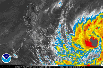
If this moved just 5 degrees N or was still 5 degrees E than where it is now... this would be one of the most impressive TC's ever. HUGE CDO. Beautiful outflow. Deep, strong convection surrounding a picturesque eye. Something you dream about that any TC can reach. So close...yet so far.
(Again completely ignoring TC's impact on land. Yes I know this could be very devastating for the Philippines and I am praying for those people over there.)
Assume that no people live in the Philippines (Hypothetically)
If this moved just 5 degrees N or was still 5 degrees E than where it is now... this would be one of the most impressive TC's ever. HUGE CDO. Beautiful outflow. Deep, strong convection surrounding a picturesque eye. Something you dream about that any TC can reach. So close...yet so far.
(Again completely ignoring TC's impact on land. Yes I know this could be very devastating for the Philippines and I am praying for those people over there.)
0 likes

-
dwsqos2
AAXX 30031 98444 21440 82730 10245 20240 47775 57195 76566 8462/ 333 56999 60587 84815 88458
Legaspi at 11 AM PHT reported winds of 30 m/s and...uh...no pressure. Incidentally, this value is greater than the peak reported during Xangsane's landfall; however, that isn't particularly useful knowledge.
Of mild interest, at 228 PM PHT, the weather station owned by typhoon2000.com reported a gust of 75 mph.
ICAMARIN2 Observations
0 likes
-
Typhoon Hunter
- WesternPacificWeather.com

- Posts: 1222
- Joined: Wed Oct 11, 2006 11:37 am
- Location: Tokyo
- Contact:
-
P.K.
- Professional-Met
- Posts: 5149
- Joined: Thu Sep 23, 2004 5:57 pm
- Location: Watford, England
- Contact:
HurricaneBill wrote:The news media does too.
Depends where you are. I've noticed over the last year or so a change in the UK media (Well the BBC) from using the JTWC to using RSMC Tokyo in their reports.
Down to 80kts, 950hPa.
RSMC TROPICAL CYCLONE ADVISORY
NAME TY 0621 DURIAN (0621)
ANALYSIS
PSTN 301200UTC 13.5N 122.4E GOOD
MOVE W 11KT
PRES 950HPA
MXWD 080KT
50KT 65NM
30KT 180NM NORTH 160NM SOUTH
FORECAST
24HF 011200UTC 13.8N 119.2E 80NM 70%
MOVE W 07KT
PRES 960HPA
MXWD 075KT
48HF 021200UTC 14.4N 117.1E 150NM 70%
MOVE W SLOWLY
PRES 950HPA
MXWD 080KT
72HF 031200UTC 14.8N 115.5E 220NM 70%
MOVE W SLOWLY
PRES 950HPA
MXWD 080KT
0 likes
Who is online
Users browsing this forum: No registered users and 62 guests