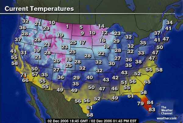
My morning low this AM was 34.
Also - of note - yesterday's high at Bush IAH was 57.
Let this be a a lesson to some members who were bashing and "frustrated" at the NWS, Channel 2, etc. for not forecasting highs in the "mid 40's". The proof will always be in the numbers.
Texas winter weather thread #2 - winter weather on Friday?
Moderator: S2k Moderators
Forum rules
 The posts in this forum are NOT official forecast and should not be used as such. They are just the opinion of the poster and may or may not be backed by sound meteorological data. They are NOT endorsed by any professional institution or STORM2K.

The posts in this forum are NOT official forecast and should not be used as such. They are just the opinion of the poster and may or may not be backed by sound meteorological data. They are NOT endorsed by any professional institution or STORM2K.
-
hurrican19
- Tropical Storm

- Posts: 153
- Joined: Sun Jun 13, 2004 1:36 pm
- Location: Northwest Austin, TX
-
Extremeweatherguy

- Category 5

- Posts: 11095
- Joined: Mon Oct 10, 2005 8:13 pm
- Location: Florida
Well technically, the NWS did make an update last night calling for 32F at IAH...and they only hit 36F. Also, 57F is below the 59F the NWS was showing a few days before hand, and up in NW Houston where they were showing 59F as well a few days ago..it only hit 55F at Hooks. So I don't know if you can call that forecast spot on.jschlitz wrote:My morning low this AM was 34.
Also - of note - yesterday's high at Bush IAH was 57.
Let this be a a lesson to some members who were bashing and "frustrated" at the NWS, Channel 2, etc. for not forecasting highs in the "mid 40's". The proof will always be in the numbers.
Also, Thursday's high would have been in the 30s or 40s had the front moved in earlier (as it once looked like would happen); so we very well could have seen highs in the 30s and 40s on that day. Also, if the front would have moved in later...say Thursday night...then yesterday would have likely been the day with 30s and 40s and clouds/rain. So really, I am not sure of the lesson I should be learning.
Anyway, on the bright side, it looks like those clouds did stick around last night and my prediction that we wouldn't drop more than a few extra degrees played out perfectly. Hooks only hit 36F (it was 38F there when I posted) and IAH only hit 36F as well (it was 38F there when I posted). Looks like the next freeze chance is Sunday night, but until then, we should hopefully be ok during the overnight hours.
0 likes
-
Extremeweatherguy
- Category 5
- Posts: 11095
- Joined: Mon Oct 10, 2005 8:13 pm
- Location: Florida
I just usually happen to have a computer in reach on most occassions I guess. lol.hurrican19 wrote:Say EWG - Do you ever sleep? Do you ever work? Do you do anything other than post on s2k? lol, not intended to be a bash on you, but seems like you're posting on here 24/7, lol. You sure know how to keep a thread going, which is nice! Keep up the good work
0 likes
-
chadtm80
-
Extremeweatherguy
- Category 5
- Posts: 11095
- Joined: Mon Oct 10, 2005 8:13 pm
- Location: Florida
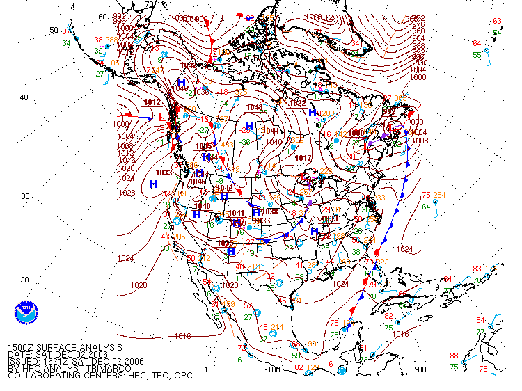
Houston morning AFD uses the term "bear watch" for the first time this season...
AREA FORECAST DISCUSSION
NATIONAL WEATHER SERVICE HOUSTON/GALVESTON TX
352 AM CST SAT DEC 2 2006
.DISCUSSION...
DECEMBER`S COLD START WILL CONTINUE OVER THE WEEKEND WITH LOW AND HIGH
TEMPERATURES AVERAGING SOME 10 TO 15 DEGREES BELOW NORMAL. THE COLD
AIRMASS ALREADY IN PLACE GETS A REINFORCING SHOT TONIGHT AND SUNDAY
AS STRONG SURFACE HIGH PRESSURE NOW OVER THE ROCKIES BUILDS INTO THE
STATE. AS A RESULT...TODAY WILL ACTUALLY BE THE WARMEST DAY OF THE NEXT
THREE. THE STRONG SURFACE HIGH WILL ALSO BRING INCREASING WINDS TO THE
AREA TONIGHT AND ON SUNDAY...ESPECIALLY NEAR AND ALONG THE COAST. THE
SUBTROPICAL JETSTREAM (SOUTHWEST FLOW ALOFT) HAS BECOME INCREASINGLY
ACTIVE ACROSS OUR AREA. THIS MOISTURE TAP EXTENDS WAY OUT INTO THE PACIFIC
OCEAN WELL TO THE SOUTHWEST OF HAWAII...AND THIS FLOW IS EXPECTED TO
BRING US PARTLY CLOUDY SKIES PROBABLY INTO THE MIDDLE OF THE UPCOMING
WEEK (AS DEPICTED WELL BY MODEL TIME SECTIONS). BY MIDWEEK..THE STRONG
SURFACE HIGH WEAKENS AND MOVES OFF TO THE EAST. THIS PATTERN CHANGE
WILL FINALLY BRING US SOME WARMER TEMPERATURES (CLOSER TO CLIMATE NORMS).
THERE ARE SOME MODEL DIFFERENCES FOR THE SECOND HALF OF THE UPCOMING
WEEK REGARDING THE STRENGTH OF THE SUBTROPICAL JETSTREAM AND EMBEDDED
IMPULSES WITHIN THIS FLOW AND POTENTIAL PHASING OF THE SUBTROPICAL AND
POLAR JETS. SOME MODELS HAVE BEEN INDICATING POSSIBLE TEXAS COASTAL
TROUGH DEVELOPMENT EVOLVING INTO A GULF OF MEXICO SURFACE LOW BY THE
END OF THE WEEK. UNTIL SOME MORE CONSISTENCY IS SHOWN BY THE MODELS...WILL
MAKE LITTLE CHANGE TO OUR CURRENT FORECAST WHICH HAS SKIES BECOMING
MOSTLY CLOUDY WITH OUR FIRST CHANCE OF RAIN ON WEDNESDAY (A SLIGHT CHANCE
OF SHOWERS). WILL KEEP IT MOSTLY CLOUDY AND CALL FOR A CHANCE OF SHOWERS
WEDNESDAY NIGHT THROUGH FRIDAY. RAIN CHANCES MIGHT NEED TO BE RAISED
SIGNIFICANTLY...ESPECIALLY NEAR THE COAST AND OFFSHORE...IF THE TROUGH
AND SURFACE LOW FORMATION MATERIALIZES. THIS DEFINITELY BEARS WATCH.
&&
0 likes
-
jasons2k

- Storm2k Executive

- Posts: 8290
- Age: 52
- Joined: Wed Jul 06, 2005 12:32 pm
- Location: The Woodlands, TX
Extremeweatherguy wrote:Well technically, the NWS did make an update last night calling for 32F at IAH...and they only hit 36F. Also, 57F is below the 59F the NWS was showing a few days before hand, and up in NW Houston where they were showing 59F as well a few days ago..it only hit 55F at Hooks. So I don't know if you can call that forecast spot on.jschlitz wrote:My morning low this AM was 34.
Also - of note - yesterday's high at Bush IAH was 57.
Let this be a a lesson to some members who were bashing and "frustrated" at the NWS, Channel 2, etc. for not forecasting highs in the "mid 40's". The proof will always be in the numbers.
Also, Thursday's high would have been in the 30s or 40s had the front moved in earlier (as it once looked like would happen); so we very well could have seen highs in the 30s and 40s on that day. Also, if the front would have moved in later...say Thursday night...then yesterday would have likely been the day with 30s and 40s and clouds/rain. So really, I am not sure of the lesson I should be learning.
Anyway, on the bright side, it looks like those clouds did stick around last night and my prediction that we wouldn't drop more than a few extra degrees played out perfectly. Hooks only hit 36F (it was 38F there when I posted) and IAH only hit 36F as well (it was 38F there when I posted). Looks like the next freeze chance is Sunday night, but until then, we should hopefully be ok during the overnight hours.
On Tuesday, when all the frustration was vented about the various forecasts, here are the numbers I pulled from the first thread:
"56 on Friday - NWS says 55 for IAH"
The 56 was from KPRC.
Also, it doesn't matter what would have been. All that matters is what was. That's what forecasts are for.
EDIT: PS - In order for Thursday's high to be in the 30s or 40s, the front would have had to come through before midnight. It was NEVER forecasted to come in that early. It was originally scheduled to come in during the afternoon...at some point there was some question if it would come in at daybreak, but never before midnight.
Last edited by jasons2k on Sat Dec 02, 2006 11:22 am, edited 1 time in total.
0 likes
-
jasons2k
- Storm2k Executive
- Posts: 8290
- Age: 52
- Joined: Wed Jul 06, 2005 12:32 pm
- Location: The Woodlands, TX
Hey gang,
Here is another request to please post static images using imageshack/photobucket/whatever instead of dynamic images.
When going back through the first winter thread - all the images posted of TWC, etc., are now updated to maps of today. It would be nice to keep an archive of the old images. It would also be nice - during the summer - to look at some of these threads and not see posted "look how COLD it is in Amarillo!!" and below it is a map showing 100F.
Thanks!
0 likes
-
Extremeweatherguy
- Category 5
- Posts: 11095
- Joined: Mon Oct 10, 2005 8:13 pm
- Location: Florida
Here is the NWS discussion from early last Wednesday and they are clearly forecasting 59F for Friday:jschlitz wrote:Extremeweatherguy wrote:Well technically, the NWS did make an update last night calling for 32F at IAH...and they only hit 36F. Also, 57F is below the 59F the NWS was showing a few days before hand, and up in NW Houston where they were showing 59F as well a few days ago..it only hit 55F at Hooks. So I don't know if you can call that forecast spot on.jschlitz wrote:My morning low this AM was 34.
Also - of note - yesterday's high at Bush IAH was 57.
Let this be a a lesson to some members who were bashing and "frustrated" at the NWS, Channel 2, etc. for not forecasting highs in the "mid 40's". The proof will always be in the numbers.
Also, Thursday's high would have been in the 30s or 40s had the front moved in earlier (as it once looked like would happen); so we very well could have seen highs in the 30s and 40s on that day. Also, if the front would have moved in later...say Thursday night...then yesterday would have likely been the day with 30s and 40s and clouds/rain. So really, I am not sure of the lesson I should be learning.
Anyway, on the bright side, it looks like those clouds did stick around last night and my prediction that we wouldn't drop more than a few extra degrees played out perfectly. Hooks only hit 36F (it was 38F there when I posted) and IAH only hit 36F as well (it was 38F there when I posted). Looks like the next freeze chance is Sunday night, but until then, we should hopefully be ok during the overnight hours.
On Tuesday, when all the frustration was vented about the various forecasts, here are the numbers I pulled from the first thread:
"56 on Friday - NWS says 55 for IAH"
The 56 was from KPRC.
Also, it doesn't matter what would have been. All that matters is what was. That's what forecasts are for.
EDIT: PS - In order for Thursday's high to be in the 30s or 40s, the front would have had to come through before midnight. It was NEVER forecasted to come in that early. It was originally scheduled to come in during the afternoon...at some point there was some question if it would come in at daybreak, but never before midnight.
http://www.srh.noaa.gov/productview.php ... =13&max=61
at the bottom of that page reads:
.PRELIMINARY POINT TEMPS/POPS...
COLLEGE STATION (CLL) 80 60 62 31 58 / 30 60 60 10 0
HOUSTON (IAH) 80 66 69 33 59 / 30 40 60 20 0
GALVESTON (GLS) 77 68 73 38 59 / 20 20 60 20 0
I am not sure what they may have been saying on Tuesday, but on Wednesday, closer to the event, they went with a warmer look for sure.
0 likes
-
jasons2k
- Storm2k Executive
- Posts: 8290
- Age: 52
- Joined: Wed Jul 06, 2005 12:32 pm
- Location: The Woodlands, TX
And it WAS warmer, was it not? On Tuesday, they forecasted 55 for Friday and it was 57...and still hitting 57 from a 59 (Wed's #) forecasted two days away isn't bad at all - esp. with a system moving through. Certainly they were a lot closer than the mid 40's you were frustrated at them for not forecasting.
0 likes

-
Stratosphere747
- Category 5
- Posts: 3772
- Joined: Thu Sep 11, 2003 8:34 pm
- Location: Surfside Beach/Freeport Tx
- Contact:
-
Extremeweatherguy
- Category 5
- Posts: 11095
- Joined: Mon Oct 10, 2005 8:13 pm
- Location: Florida
I just went back and checked, and I hadn't called for mid 40s as a possibility since last weekend (when pretty much everyone was still not sure of the exact situation). But by last Tuesday I had gone with a much warmer idea thinking highs in the lower 50s and lows in the 20s. That idea came true because on Friday I hit 54F (Hooks hit 55F) and my low was 27F (29F at Hooks). I don't think I was ever "frustrating" the NWS with highs in the mid 40s during the days immediately leading up to the event. All I was saying during those days was that 59F was probably too warm..which it ended up being.jschlitz wrote:And it WAS warmer, was it not? On Tuesday, they forecasted 55 for Friday and it was 57...and still hitting 57 from a 59 (Wed's #) forecasted two days away isn't bad at all - esp. with a system moving through. Certainly they were a lot closer than the mid 40's you were frustrated at them for not forecasting.
ALSO: There were other PRO METS calling for highs in the 40s to near 50 on Friday as well, so it was not like it was just me. Keep that in mind.
Last edited by Extremeweatherguy on Sat Dec 02, 2006 12:22 pm, edited 2 times in total.
0 likes
-
Extremeweatherguy
- Category 5
- Posts: 11095
- Joined: Mon Oct 10, 2005 8:13 pm
- Location: Florida
dude.."winter weather" can mean cold, cold rain, snow, sleet, anything that has to do with weather during winter. I nowhere in my above post even mentioned anything remotely close to that meaning winter precipitation at all. All I said was that they used the term "bear watch" for the first time and that I thought that was interesting.Stratosphere747 wrote:J -- Your talking to a brick wall...
Also that "Bear watch" has nothing to do with any winter weather. It is for rain...
Being that this is a "winter weather" thread....
0 likes
-
Stratosphere747
- Category 5
- Posts: 3772
- Joined: Thu Sep 11, 2003 8:34 pm
- Location: Surfside Beach/Freeport Tx
- Contact:
Extremeweatherguy wrote:dude.."winter weather" can mean cold, cold rain, snow, sleet, anything that has to do with weather during winter. I nowhere in my above post even mentioned anything remotely close to that meaning winter precip. at all. All I said was that they used the term "bear watch" for the first time and that that was interesting.Stratosphere747 wrote:J -- Your talking to a brick wall...
Also that "Bear watch" has nothing to do with any winter weather. It is for rain...
Being that this is a "winter weather" thread....
"Dude"
What season are you talking about, that they are using "bear watch" for the first time?
0 likes
-
Extremeweatherguy
- Category 5
- Posts: 11095
- Joined: Mon Oct 10, 2005 8:13 pm
- Location: Florida
the winter season. But just because it is during winter doesn't mean it has to do with winter precipitation, does it? It just happens to be the first time I have seen that term used in quite some time.Stratosphere747 wrote:Extremeweatherguy wrote:dude.."winter weather" can mean cold, cold rain, snow, sleet, anything that has to do with weather during winter. I nowhere in my above post even mentioned anything remotely close to that meaning winter precip. at all. All I said was that they used the term "bear watch" for the first time and that that was interesting.Stratosphere747 wrote:J -- Your talking to a brick wall...
Also that "Bear watch" has nothing to do with any winter weather. It is for rain...
Being that this is a "winter weather" thread....
"Dude"
What season are you talking about, that they are using "bear watch" for the first time?
0 likes
-
jasons2k
- Storm2k Executive
- Posts: 8290
- Age: 52
- Joined: Wed Jul 06, 2005 12:32 pm
- Location: The Woodlands, TX
All I can say is look at some of the posts on pages 6,7,8,9, etc. of the first thread. It's plain as day to anyone reading it. You blasted the NWS Houston for not mentioning any frozen precipitation and "going with the warmest possible scenarios......not taking any risks". You praised JB and hoped we'd be making snowballs this weekend, among other things. Some of us tried to put things into perspective in a polite way but you would have none of it. Stratos is right, I do feel like I'm talking to a brick wall. Time to step away, do some shopping, and enjoy this beautiful day.
0 likes
-
Extremeweatherguy
- Category 5
- Posts: 11095
- Joined: Mon Oct 10, 2005 8:13 pm
- Location: Florida
-
JonathanBelles
- Professional-Met

- Posts: 11430
- Age: 35
- Joined: Sat Dec 24, 2005 9:00 pm
- Location: School: Florida State University (Tallahassee, FL) Home: St. Petersburg, Florida
- Contact:
-
HarlequinBoy

- Category 5
- Posts: 1400
- Age: 35
- Joined: Wed Nov 29, 2006 1:57 am
- Location: Memphis
Who is online
Users browsing this forum: SnowyOwl31, TomballEd and 82 guests